
Where Flight Simulation Enthusiasts Gather from Around the World!
AVSIM Library - Search Results

| Category: Flight Simulator 2004 - AI Aircraft | |
| AI Mexicana de Aviacion Airbus A320-214 New and Old Liveries Pack |

|
Images related to this file:
File Description:
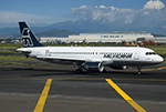
This is the Third Oldest Airline in the world, the Second Oldest Airline in Latin America, and the First Oldest Airline in Mexico, Mexicana Airlines (Mexicana de Aviacion), this is the Airbus A320-214 CFM for the pack have the New Livery (2010), Old Livery (2005), Oneworld Livery, White Colors, Albine Colors, Green Engines, White Engines, the registrations are: N213MX (With New Colors included), N566BB, XA-MXD (With White Colors included), XA-MXF (With New Colors included), XA-MXK (With Oneworld livery included), XA-MXL (With New Colors included), XA-UDT (With Albine Colors), XA-UDU, XA-VIP. For the 100th Anniversary I´ll upload all the fleet, since 1940´s with the DC-2 to the last fleet that had when it flies, the Mark and Airline still exists, BUT It doesn´t fly since 2011. This is my website: https://el-mundo-de-los-aviones-ai-traffic.jimdosite.com The model is FSX AI Bureau (FAIB) Airbus A320 CFM Basepack. I hope you enjoy it!.
| Filename: | AI_Mexicana_de_Aviacion_Airbus_A320214_New_and_Old.zip |
| License: | Freeware |
| Added: | 25th November 2022, 20:16:59 |
| Downloads: | 54 |
| Author: | Jesus Gibran Soriano Solleiro |
| Size: | 96.67 MB |
| Category: Flight Simulator 2004 - Aircraft Repaints, Textures and Modifications | |
| Fuerza Aerea Uruguaya Lockhhed C-130B Hercules FAU-591 and FAU-592 |
|
File Description:
Fuerza Aerea Uruguaya Lockheed C-130B FAU-591 CX-BQW(C/N 3668)and FAU-592
CX-BQX(C/N 3596).This planes are in service with the Escuadrón Aéreo No.3(Transporte)
at BA 1 at Montevideo Carrasco.Several missions in Antartic and Eritrea were
acomplished by this planes.
Original by Mike Stone.
Repainted,panel and flight dynamics by Daniel Nole.FAUsim http://fau510.webs.com/
| Filename: | Fuerza_Aerea_Uruguaya_Lockhhed_C130B_Hercules_FAU5.zip |
| License: | Freeware |
| Added: | 3rd April 2009, 07:37:22 |
| Downloads: | 141 |
| Author: | Daniel Nole |
| Size: | 3.34 MB |
| Category: Flight Simulator X - Aircraft Repaints, Textures and Modifications | |
| Air China Boeing 737-800 NGX 'Waves and Peacock' Livery B-5422 |
|
Images related to this file:
File Description:

Air China ( B-5422 ) 737-800 Waves and Peacock Livery, Winglets. Repaint only for FSX payware PMDG 737 NGX aircraft. You must own the PMDG 737NGX. Livery Manager install.
| Filename: | Air_China_Boeing_737800_NGX_Waves_and_Peacock_Live.zip |
| License: | Freeware, limited distribution |
| Added: | 3rd April 2013, 02:07:00 |
| Downloads: | 3,015 |
| Author: | John O'Duffy |
| Size: | 15.09 MB |
| Category: Flight Simulator X - Aircraft Repaints, Textures and Modifications | |
| China Southern Airlines, Boeing 737-800 and -800WL (B-5300 & B-5120) |
|
Images related to this file:
File Description:
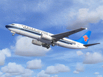
Project Opensky (Free Sky Project) Boeing 737-800 Series China Southern Airlines Complete Package for FSX. Repaints of both B737-800 & B737-800WL are included, registered respectively as B-5300 & B-5120. Texture by He Lingyuan, China. Using Panel, Sound & Virtual Cockpit of the default B737-800. Operation Manual by Warren C.Daniel of Project Opensky Team is also included.
| Filename: | China_Southern_Airlines__Boeing_737800_and_800WL_B.zip |
| License: | Freeware, limited distribution |
| Added: | 9th April 2011, 20:33:27 |
| Downloads: | 666 |
| Author: | He Lingyuan, Project Opensky (Free Sky) |
| Size: | 23.26 MB |
| Category: Flight Simulator 2004 - AI Aircraft | |
| Bulgarian Air Charter MD-82 fleet updates and Summer 2010 charter programme. |
|
Images related to this file:
File Description:

Bulgarian Air Charter MD82 fleet updates '2010' repaints for AI traffic. This is another painkit enhancement. I have again updated the wing/fin textures, which I think looks more like the real thing now.
| Filename: | Bulgarian_Air_Charter_MD82_fleet_updates_and_Summe.zip |
| License: | Freeware |
| Added: | 22nd August 2010, 20:13:36 |
| Downloads: | 2,946 |
| Author: | Billy Rutherford |
| Size: | 5.34 MB |
| Category: Flight Simulator 2004 - Aircraft Repaints, Textures and Modifications | |
| Alaska Airlines "Honoring Those Who Serve" Boeing 737-800 and 737-900ER |
|
Images related to this file:
File Description:
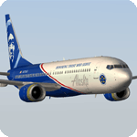
The Honoring Those Who Serve plane is dedicated to the brave men and women of the US military, as well as veterans of the armed forces and their families. Its unique exterior paint scheme, conceived by a small group of Alaska maintenance technicians, was designed to symbolize remembrance, pride, and appreciation. The design includes a red stripe and blue aircraft body to incorporate elements of the American flag; the phrase "Honoring Those Who Serve," displayed on the fuselage; a symbolic crest representing the Alaska Airlines Fallen Soldier Program to the right of the cargo door; and an "Alaska Airlines Salutes" medallion on the right of the boarding door near the nose of the aircraft, with five stars representing the five branches of the U.S. Armed Forces: Air Force, Army, Navy, Marine Corps and Coast Guard. The special livery was created in partnership with Boeing and is featured on two aircraft; N570AS, a 737-800, and sister ship N265AK, a 737-900.
Model developed by Tenkuu Developers Studio, features high resolution textures, dynamic flexing wings, nose gear steering, rudder lock, ground spoilers, low speed aileron locks at high speed, fully animated control surfaces, fully independent suspension, trim animation, opening passenger doors, rolling wheels, animated thrust reversers with reverser block doors, detailed textures, full night lighting, ground service vehicles and more. Model design by Hiroshi Igami. Flight dynamics design by Nick Wilkinson, with assistance from David Biggar. Master textures and paint kit by Kyle Schurb. Textures only for the great TDS model. Enjoy!
| Filename: | Alaska_Airlines_Honoring_Those_Who_Serve_Boeing_73.zip |
| License: | Freeware |
| Added: | 1st June 2019, 21:06:47 |
| Downloads: | 610 |
| Author: | Joe Shimmel | Tenkuu Developers Studio |
| Size: | 18.77 MB |
| Category: Flight Simulator 2004 - Scenery | |
| EGGP Local Landmarks - Daresbury Research Centre and Norton Water Tower Ver 2.0 |
|
Images related to this file:
File Description:

This continues the series of individual landmark sceneries for use while VFR flying in the area of Liverpool John Lennon Airport (EGGP).
This scenery has been designed to compliment the Liverpool John Lennon Airport Scenery also by DerboSoft.
The scenery is aligned to the Visual Flight / Getmapping VFR Scenery published by Just Flight but is also fully compatible with both the FS2002 and FS2004 default sceneries.
Version 1.0 of this scenery was previously included in the main Liverpool John Lennon Airport Scenery download (before ver 4.0) and should be removed before installation.
| Filename: | EGGP_Local_Landmarks__Daresbury_Research_Centre_an.zip |
| License: | Freeware |
| Added: | 26th June 2004, 23:41:41 |
| Downloads: | 5,075 |
| Author: | Paul Derbyshire |
| Size: | 46.78 KB |
| Category: Flight Simulator 2004 - Aircraft Repaints, Textures and Modifications | |
| Boeing 777-200 Nordwind Airlines VP-BJH (with and without Nordwind logo) |
|
Images related to this file:
File Description:
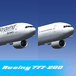
Nordwind Airlines VP-BJH (with and without Nordwind logo) for SkySpirit2012's 777-200 RR model! painted by HT repaints, model not included.
| Filename: | Boeing_777200_Nordwind_Airlines_VPBJH_with_and_wit.zip |
| License: | Freeware |
| Added: | 11th August 2019, 18:09:45 |
| Downloads: | 259 |
| Author: | HT Repaints |
| Size: | 19.5 MB |
| Category: Prepar3D V5 - AI Aircraft | |
| FSPXAI Etihad Airways 777-300ER Albino Fleet (A6-ETA and A6-ETE) |
|
Images related to this file:
File Description:
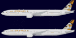
Etihad Airways "Albino" T7 fleet to be used with FSPXAI 777-300ER model.
| Filename: | FSPXAI_Etihad_Airways_777300ER_Albino_Fleet_A6ETA_.zip |
| License: | Freeware |
| Added: | 29th April 2024, 16:00:00 |
| Downloads: | 87 |
| Author: | Najib Sami |
| Size: | 1.89 MB |
| Category: Flight Simulator 2004 - Scenery | |
| Ketchikan PAKT in southern Alaska plus float planes 5KE and the town |
|
Images related to this file:
File Description:
This is Ketchikan PAKT in southern Alaska, 45 miles north of the Canadian border and 220 miles south of Juneau. It is the closest major Alaskan airport to the lower 48 and most flights from or to Seattle pass through Ketchikan en route. The airport is on the southern side of the stretch of water known as The Narrows and the town is on the northern side, with ferries connecting the two. The town side was somewhat modified as part of one of the three Misty Fjords sceneries, so there were already some marinas and docked cruise liners etc before I started this. In addition, Ketchikan Airport had been partly made way back in 2006, and further modified in 2007; I say "partly" as there is in fact no way to accurately make PAKT within the limitations of FS9 as there is a 50 or 60 feet difference in elevation between runway and apron, and the taxiways are actually ramps up from the apron to the ends of the runway. This has a knock-on effect on the float plane and ferry docks on the water below the airport. I can see why the Misty Fjord sceneries avoided it. This scenery retains the original buildings from the Alan Wright scenery. It also includes the modification made by John Hinson, who created the second taxiway to the western end of the runway; FS9 had not included this as the original airport started operations with only one taxiway in place. There are new vehicles on the apron (fuel etc), new apron markings and some parking modifications to enable AI with Boing 737, DC6, Beechcraft 1900, and GA, plus runway and taxiway signage, windsocks, some car parking, freight items, etc. There is a road and covered bridges down to the docks and ferry, and the town side of the water has been modelled to include other float plane docks along with waterfront buildings, including the ship repair facility with it's dry dock (actually a floating dock that lifts ships out of the water) and the Alaskan Ferry Terminal wharf etc. The ferry forms a part of the AI, generously permitted by FSAddon and originally a part of the payware Tongass Fjords package, as are the AI aircraft also included here. There are new waterside buildings that stretch from the ship repair yard, past the shopping plaza and onward to the stationary cruise liners (that were part of the Tongass payware scenery) including float docks for the float plane companies that are based in Ketchikan, plus a new AI liner. The AI is a further adaptation of the already posted CF36 AI and PAKN AI, as listed in the AI folder. Due to the surrounding hills there may be some interference with AI float aircraft, depending on the wind direction, though I have watched succesful Beaver landings with the wind from the east. The combined AI for float planes creates a float plane take off or landing at, on average, 20 minute intervals; this is still well short of the actual busy summertime period.
| Filename: | Ketchikan_PAKT_in_southern_Alaska_plus_float_plane.zip |
| License: | Freeware, limited distribution |
| Added: | 12th February 2017, 23:27:59 |
| Downloads: | 1,238 |
| Author: | Roger Wensley |
| Size: | 47.11 MB |


© 2001-2026 AVSIM Online
All Rights Reserved
Privacy Policy |