
Where Flight Simulation Enthusiasts Gather from Around the World!
AVSIM Library - Search Results

| Category: Flight Simulator 2004 - Scenery | |
| Bella Coola CYBD in British Columbia, Canada |

|
Images related to this file:
File Description:
Bella Coola is in one of the deep east-west fjords amid the Coastal Range on the coast of BC, approximately mid way between Vancouver and the Alaskan border and some 70 miles inland from the open ocean. The town of Bella Coola has a small population of around 150, while the population of the whole Bella Coola Valley is around 2,000. The valley is warmer in both summer and winter than the surrounding area, and tourism flourishes along with forestry, fishing, and local government administration. Although there is road access, the ferry service is the main connection to larger coastal towns or cities such as Vancouver. The airport, 7 miles east of the town, is connected by daily Pacific Coastal flights to Vancouver and Anahim Lake (to the east). The asphalt runway is 4,200 feet long and aligned 04-22 in FS9 (by 2010 this had changed to 05-23 in reality) and is without lighting of any sort, so it is restricted to daylight hours only. At the eastern end is the terminal building and in the middle the West Coast Helicopter hangar, which has a large fenced paddock-like enclosure in front of it. The helicopters hop over the three feet high fence as they "taxi" to the apron in front of the hanger (but not in FS9!). Between the two there are four other company hangars spread out along the roadway beside the fence. I have never seen the airfield in Summer, and I have not attempted to replicate the apron as it now shows in Google Earth. The screenshots show the main and overwhelming feature of Bella Coola, the large valley amid the steep mountains. This terrain has an inevitable effect on the ai, in that you will never see a plane land as it hits solid rock before it makes it to the runway. You will, however, see them take off. Pacific Coastal currently flies Beechcraft 1900's to Bella Coola; I have used the Saab 340 which I have seen there some years ago and which I prefer.
| Filename: | Bella_Coola_CYBD_in_British_Columbia_Canada.zip |
| License: | Freeware, limited distribution |
| Added: | 25th October 2018, 17:57:06 |
| Downloads: | 285 |
| Author: | Roger Wensley |
| Size: | 14.57 MB |
| Category: Flight Simulator X - Scenery | |
| RAF Hooton Park - Cheshire, England |
|
File Description:
RAF Hooton Park, on the Wirral Peninsula, Cheshire, was a Royal Air Force station originally built for the Royal Flying Corps in 1917 as a training aerodrome for pilots in World War I. During the early/mid-1930s, it was one of the two airfields (with Liverpool Speke) handling scheduled services for the Merseyside region. Hooton Park was home to No. 610 (County of Chester) Squadron and, post World War II, to No. 611 (West Lancashire) and No. 663 (AOP) Squadron.
The airfield closed in 1957 after the disbandment of the Royal Auxiliary Air Force, but the three pairs of Belfast Truss hangars erected in 1917 survived the closure. The site was bought by Vauxhall Motors, who built their Vauxhall Ellesmere Port plant there, which today produces the Vauxhall Astra. A small remaining section of the airfield site is now owned and managed by The Hooton Park Trust. The hangars are also home to The Griffin Trust and an aircraft preservation society named The Aeroplane Collection. Another part of the old airfield, including a length of the old paved runway, perimeter track and the apron used to park Meteor jet fighters, remains in the ownership of The Naylor Trust. A Second World War B1 hangar is also on this site.
Third party add-on's will be required see the readme.txt for details.
| Filename: | RAF_Hooton_Park___Cheshire_England.zip |
| License: | Freeware |
| Added: | 13th December 2015, 12:12:02 |
| Downloads: | 195 |
| Author: | Terry Boissel |
| Size: | 1.47 MB |
| Category: Flight Simulator 2004 - Scenery | |
| Nikolski (IKO), Nelson Lagoon (Z73), & Perryville (AK5) - Alaska, USA |
|
Images related to this file:
File Description:
These are villages in Alaska, spread out east and west of Dutch Harbor in the Aleutians and the peninsula, served by Grant Aviation regional flights from Dutch Harbor, Cold Bay, or King Salmon.
Nikolski is 115 miles west of Dutch Harbor at the western end of Umnak Island, which is just west of Unalaska, the large island adjacent to Dutch Harbor. Nikolski is small, with a population of perhaps only 20 now, and the main claim to fame is the wrecked Reeve Aleutian DC3 at the end of the runway. The runway is 3,500 feet of gravel aligned 08-26. Nelson Lagoon is on the north shore of the peninsula, 55 miles north of Sand Point and on a long spit of land that curves around to make the lagoon. There is no access except by boat or plane for the population of around 50. The airfield is a mile east of the village with a gravel runway 08-26, 4,000 feet long. Perryville is on the south shore of the peninsula, 65 miles east of Sand Point. The population is around 115, and the airfield is southwest of the town with the 3,500 feet of gravel runway aligned 02-20 beside the shore. There is a hangar on the apron, but no terminal building.
| Filename: | Nikolski_IKO_Nelson_Lagoon_Z73__Perryville_AK5__Al.zip |
| License: | Freeware, limited distribution |
| Added: | 14th March 2015, 13:27:53 |
| Downloads: | 255 |
| Author: | Roger Wensley |
| Size: | 11.45 MB |
| Category: Flight Simulator 2004 - Scenery | |
| Peace River CYPE in northwest Alberta, Canada UPDATED |
|
Images related to this file:
File Description:
This is an updated version of the original post (from 2014) made in November 2018. It provides missing textures, and deals properly with an ai problem that I thought I had already fixed. It also adds extra objects to the apron area and adds a third gate. It is complete in itself and can be installed as-is if you do not have the original post. The Peace River flows east from the Rockies, joining up with the Slave River to empty into Great Slave Lake. The town is on both banks close to a bend where the Peace turns to the north, 245 miles northwest of Edmonton. The population is 7,000 and the surrounding area is either farmland or forest. The airport is just over 3 miles west of the town. The runway is 5,000 feet of wide asphalt (150 feet) aligned 04/22, lit, and with PAPI. There is a second runway to the south of the main runway, 1,900 feet of grass and aligned 08/26. The apron is to the north of the runway at the eastern end and is large; there is a purpose-built terminal building, plus other hangar buildings along taxiway C that extends westward from the apron. The airport is experiencing an increase in scheduled and GA flights in the last few years.
| Filename: | Peace_River_CYPE_in_northwest_Alberta_Canada_UPDAT.zip |
| License: | Freeware, limited distribution |
| Added: | 10th December 2018, 17:33:25 |
| Downloads: | 127 |
| Author: | Roger Wensley |
| Size: | 24.27 MB |
| Category: Flight Simulator 2004 - Scenery | |
| Valdez Pioneer Field PAVD in Alaska |
|
Images related to this file:
File Description:
Pioneer Field is in Valdez Alaska, between the mountains to the north and the water of Valdez Arm to the south. It used to cater for a lot of the work for the Alaskan pipline and the nearby terminal and in the middle 1970's it was a very busy place. That is not the case now, and the tower is no longer manned though there is still an average of 35 flights a day and there are 30 planes (and helicopters) based at the field. There are three really odd hangars at the western end of the apron, with each of them having 6 "T" hangars which have been joined in a circle; this is the only place I have ever seen this. The recently resurfaced runway is 6,500 feet of 150 feet wide asphalt aligned 6/24 at 121 feet asl. There is also a wide and heavy duty asphalt and gravel surrounding runoff and base, probably because of drainage problems with water from the mountains. Fuel (both JetA and 100LL) is available from ERA Helicopters at the eastern end of the apron. All of the buildings on the field have been modelled specifically for this scenery, plus the nearby accomodation blocks. The AI flights are for the twice-daily ERA/Alaska Air flights using a Bombardier Dash 8-200.
| Filename: | Valdez_Pioneer_Field_PAVD_in_Alaska.zip |
| License: | Freeware, limited distribution |
| Added: | 21st January 2011, 03:29:51 |
| Downloads: | 1,198 |
| Author: | Roger Wensley |
| Size: | 3.97 MB |
| Category: Flight Simulator 2004 - Scenery | |
| Chignik Lake A79 and Port Heiden PAPH - Alaska, USA |
|
Images related to this file:
File Description:
These are two villages in Alaska, in the peninsula that is the start of the Aleutians. Both are east of Perryville, Chignik Lake by 30 miles on the south side of the peninsula and Port Heiden by 75 miles on the north coast. Both are served by Grant Aviation government-subsidised regional flights from King Salmon. Chignik Lake has a population of around 70. There are two buildings on the airfield, but passengers still wait in their car for the plane to arrive as there is no terminal building as such. The runway is 3,300 feet of gravel aligned 08-26, as are so many in this area. Port Heiden is on the north shore of the peninsula, and the population is around 100. FS9 showed the town as being large enough to house 10,000; the new landclass here reduces this to the actual 40 or so houses, one and a half miles south of the airport. The roads are still the FS9 originals, which are approximately in the right place but are brightly lit at night as I was too lazy. The main occupation is fishing. There are buildings on the airfield (mostly old, except for a garage building) but passengers again wait in their cars for the plane to arrive. The two runways are both gravel, and are 05-23 of 6,200 feet, and 13-31 of 4,400 feet.
| Filename: | Chignik_Lake_A79_and_Port_Heiden_PAPH__Alaska_USA.zip |
| License: | Freeware, limited distribution |
| Added: | 30th March 2015, 20:28:47 |
| Downloads: | 292 |
| Author: | Roger Wensley |
| Size: | 5.1 MB |
| Category: Prepar3D V1-4 - Aircraft Repaints, Textures and Modifications | |
| North American T-6 Texan (ZS-WLP) |
|
Images related to this file:
File Description:
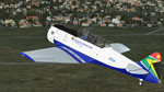
This is an artistic representation of C/N 88-15699, SAAF 7601. The aircraft was built by North American Aviation. Allocated the tail number 41-34067. Diverted from the United States to the RAF with tail number EZ194. Delivered to the SAAF and allocated the tail number 7601. The aircraft was transferred to the Gabon Presidential Guard on the 15th of December 1970 and was identified by the letter 'G'. Returned to the SAAF with its original tail number 7601. The aircraft was rebuilt to airworthy standard and registered ZS-WLP on the 8th of March 1990 and named 'Spook' (Ghost). The aircraft is used for hands on training for a live aircraft and is usually displayed at various air shows and functions. These are textures only and you need a legal copy of the A2A T-6 Texan
| Filename: | North_American_T6_Texan_ZSWLP.zip |
| License: | Freeware |
| Added: | 29th April 2018, 00:24:51 |
| Downloads: | 70 |
| Author: | Eberhard Haberkorn / A2A |
| Size: | 44.91 MB |
| Category: Flight Simulator X - Aircraft Repaints, Textures and Modifications | |
| American Airlines NC Boeing 787-8 GE *** UPDATE *** |
|
Images related to this file:
File Description:

American Airlines NC Boeing 787-8 GE, for use with the Aerosim payware Boeing 787 (www.aerosim.co.jp).
This update of aalnc788ge.zip is a complete re-paint of the base colours of the fuselage and engines, creating patterns and gradients which better represent the mica silver used on the real aircraft. The gradients presented all sorts of interesting challenges matching where the textures get mapped onto the air frame in order to ensure that there are no stark differences at the joins. The work is now complete and the result is that the aircraft now really looks more silver than plain grey.
After completing the base colours, many fine details were also updated - such as cargo doors, decals, APU doors, nose cone, paint around the cockpit windows, detail under the fuselage, warning lines on engine and fuselage, and much more.
| Filename: | American_Airlines_NC_Boeing_7878_GE__UPDATE_.zip |
| License: | Freeware |
| Added: | 15th February 2013, 16:19:09 |
| Downloads: | 4,577 |
| Author: | Brian Robinson |
| Size: | 8.91 MB |
| Category: Flight Simulator 2004 - AI Aircraft | |
| U-Land Airlines, McDonnell Douglas MD-82, B-88899 |
|
Images related to this file:
File Description:
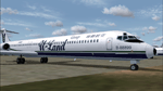
This is the livery repainted by use of the Paintkit which was made by David Rawlins. The "zip" file contained texture files only and to be used with the AI Aardvark MD-8X Base Model available separately: (aia_md8x.zip).
U-Land Airlines was famous for its permotion price on first day operation "one NT dollar ticket". After that they set the ticket price to NT$800 from Taipei(RCSS) to Kaochung(RCKH). That was really under the market prices. They set the LCD screens for every seats and introduced the airshow system to all the passengers. That was really a pioneer in that time but the cost was far above the profit. At the year 2000, This company was forced to shut down the operation and never again. The Callsign was "U Land" and the three digit code was "ULA".
| Filename: | ULand_Airlines_McDonnell_Douglas_MD82__B88899.zip |
| License: | Freeware |
| Added: | 16th May 2011, 10:09:04 |
| Downloads: | 170 |
| Author: | Ren-Jie Wu |
| Size: | 234.5 KB |
| Category: Flight Simulator 2004 - Scenery | |
| Georgian Bay Airfields CYEM & CNR4 in Ontario, Canada |
|
Images related to this file:
File Description:
These are two airfields in Ontario around Georgian Bay, which is off the east side of Lake Huron in the Great Lakes. Manitoulin East Muni CYEM is at the northern end of the Bay in an area of coves and lakes, on what is actually an island that is almost but not quite connected to the mainland in several places. There is no immediately adjacent town and the field serves the county area. The runway is 3,500 feet of asphalt aligned 02-20 with PAPI at both ends. The second airfield is Tobermory CNR4, which is just south of the small town and ferry terminal of the same name on the northern end of the peninsula that forms Georgian Bay. The runway is 3,180 feet long and aligned 12-30; there is no longer a 450 feet displacement to the 30 threshold.
| Filename: | Georgian_Bay_Airfields_CYEM__CNR4_in_Ontario_Canad.zip |
| License: | Freeware, limited distribution |
| Added: | 12th August 2018, 19:31:18 |
| Downloads: | 138 |
| Author: | Roger Wensley |
| Size: | 17.45 MB |


© 2001-2026 AVSIM Online
All Rights Reserved
Privacy Policy |