
Where Flight Simulation Enthusiasts Gather from Around the World!
AVSIM Library - Search Results

| Category: Flight Simulator X - Aircraft Repaints, Textures and Modifications | |
| Douglas C-47 (N65276) Frontier Airlines |

|
Images related to this file:
File Description:
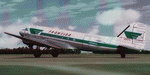
This folder contains a repaint for version 3.14 of the Douglas C-47 by Manfred Jahn and colleagues in the colors of Frontier Airlines N65276, one of the C-47/DC-3's operated by Frontier Airlines. On April 21, 1957, at 1321 hours, N65276, operating as Frontier Airlines flight 7 departed Prescott, Arizona enroute to Phoenix under visual flight rules (VFR) with 21 passengers and one stewardess. As the flight proceeded southbound toward Phoenix the weather deteriorated to a point where the flight could no longer remain clear of clouds and maintain VFR. Captain Welling requested and received an instrument flight rules (IFR) clearance to proceed to Phoenix via Knob intersection thence to the Phoenix omni range, maintain 7000 feet. The crew never acknowledged receiving the clearance. It is suspected that the reason there was no response is that this was the precise moment that flight 7 struck the west ridge of a mountain at the 4500’ level southeast of Prescott shearing off twelve feet of the left wing and six feet of the left aileron. After declaring an emergency, flight 7 landed safely at Phoenix Sky Harbor airport without further incident. There was no injury to the passengers or crew. The wing was replaced and the aircraft continued flying for Frontier. Sadly, N65276 was lost in a tragic accident in 1967 on a snowy Denver day when a rudder-lock had been placed on an elevator and not removed prior to take-off. Both pilots were killed in the crash. More info, as well as pictures, on these incidents, and an earlier mishap with N65276 can be found here: http://fal-1.tripod.com/FL_Crash.html.Repaint by Jan Kees Blom for Manfred Jahn's C-47 version 3.14, based on the paintkit by Gman5250.
| Filename: | Douglas_C47_N65276_Frontier_Airlines.zip |
| License: | Freeware |
| Added: | 14th August 2018, 21:34:27 |
| Downloads: | 380 |
| Author: | Jan Kees Blom |
| Size: | 13.82 MB |
| Category: Flight Simulator 2004 - Scenery | |
| Hazyview Airfield, Hazyview, South Africa |
|
Images related to this file:
File Description:
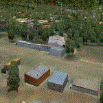
Hazyview is one of the gateway towns to the Kruger National Park and is located just to the West of Phabeni Gate, one of the main gates to use if you are travelling to Skukuza. The airfield in Hazyview is also called Numbi Airfield due to the location of the Numbi Hotel right next to the airfield.
Hazyview airfield is not included in the default scenery of FS2004. With this package, it has been faithfully produced in Gmax with photoreal textures on all the buildings and a photoreal ground as well. Even the Lowveld mall to the North of the airfield and right on the approach to Rwy 19 as well as the Building supplies store to the south and on approach to Rwy 01 is inlcuded with custom models and textures. Likewise, the buildings to the West of the runway (right at the edge of the runway) and the brickyard at the Northern end is modeled with custom models and textures. The two large cellphone antennas are also present in the airport scenery and custom made.
In real life, the runway is quite sloped and this was also recreated in the scenery under the limitations FS2004 presents with regards to non-flat airports.
The grass runway is aligned 01/19 and only 820m long. Take-off is on Rwy 01, with landings on Rwy 19.
| Filename: | Hazyview_Airfield_Hazyview_South_Africa.zip |
| License: | Freeware, limited distribution |
| Added: | 4th February 2022, 14:57:40 |
| Downloads: | 139 |
| Author: | Kobus van Wyk |
| Size: | 17.07 MB |
| Category: Flight Simulator X - Aircraft Repaints, Textures and Modifications | |
| Delta Airlines Boeing 757-200 (N672DL) |
|
Images related to this file:
File Description:

TDS (Tenkuu Developers Studio) Boeing 757-200 PW 2040 model, in the Delta Wavy Gravy livery, registration N672DL. Includes custom Cabin and Ground Support Equipment and personnel textures and both winglet textures for those that want to use winglets. Lots of mild weathering and other new details including photo real refuel station under right wing as well as the refueling access panel and new wing textures. New photoreal Landing and taxi light lenses on the nose gear and wings. A special thanks to Luis Castro for the winglet night lighting and the photoreal wing tops and flaps and Nick Chinn for the refueling station photos from a real Delta 757 that helped me enhance these textures even more....
Model developed by Tenkuu Developers Studio, features high resolution textures, dynamic flexing wings, nose gear steering, rudder lock, ground spoilers, low speed aileron locks at high speed, fully animated control surfaces, fully independent suspension, trim animation, opening passenger doors, rolling wheels, animated thrust reverse with reverser block doors, detailed textures, full night lighting, ground service vehicles and more. Model design by Hiroshi Igami. Flight dynamics design by Nate Rosenstrauch and Joe DeGregorio. Paint kit and master textures by Carlos Eduardo Salas. TDS members: Hiroshi Igami,Nick Wilkinson,Carlos Eduardo Salas,Yosuke Ube,Stian Svensen,David Biggar, Luiz Antonio Perina,Nate Rosenstrauch, Joe DeGregorio. By Joe DeGregorio. Enjoy!!
| Filename: | Delta_Airlines_Boeing_757200_N672DL.zip |
| License: | Freeware |
| Added: | 16th October 2018, 16:26:56 |
| Downloads: | 497 |
| Author: | Joe DeGregorio - TDS |
| Size: | 12.79 MB |
| Category: Prepar3D V1-4 - Utilities | |
| FS Flight Builder |
|
Images related to this file:
File Description:
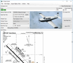
FS Flight Builder is a utility for general aviation flying that will build flight files for FSX (flt), FSX Steam Edition (flt), and Prepar3D (fxml) based on waypoints and other data either entered manually or imported from SkyVector using the Plain Text Link information. Among other things, you can select your starting position, aircraft, and a VFR or IFR flight plan.
One of the most interesting features of the application is that it will include a Briefing file, added to the aircraft's built-in kneedboard, that will include departure and destination airport information (runways, frequencies, weather, and charts) as well as navigation frequencies along the route.
Included is a new destination chooser function that allows you to enter your departure airport and additional criteria, such as min and max distance, tower required, ILS, runway length restrictions.
| Filename: | FS_Flight_Builder.zip |
| License: | Freeware |
| Added: | 30th July 2018, 03:56:07 |
| Downloads: | 148 |
| Author: | Tom Arduini |
| Size: | 28.24 MB |
| Category: Flight Simulator 2002 - Flight Plans | |
| 53RTWest |
|
File Description:
An FS2002 GPS flight Plan by the Ancient Brit. The 53rd in a series of Round the World flight plans for the FS2002 default scenery. Depart Kulusuk (BGKK) runway 11, Greenland and arrive 2 hours 9 minutes later at Kangerlussuaq (BGSF) runway 10 Greenland. The direct distance is 337 nm, but I have gone the ‘pretty way’ taking 621 nm and using 1,340 custom waypoints in the process. The departure takes you for a low level tour (500 ft) along Fjords and between mountains, climbs to cruise then descends for another low level tour (500 ft) along Fjords and between mountains, before finishing with a VFR landing (Hand holding instructions given). The flight briefing (Word and text) is for the default B737-400; it contains climb, cruise, top of descent and fuel loading details, waypoint timings and destination details.
| Filename: | 53RTWest.zip |
| License: | Freeware |
| Added: | 22nd March 2003, 10:47:54 |
| Downloads: | 556 |
| Author: | Denis Egan |
| Size: | 33.07 KB |
| Category: Flight Simulator 2004 - Scenery | |
| Fronconia NH 1B5 |
|
File Description:
This is my first attempt at making any kind of scenery for Flight Simulator. I live in Boston and love getting up into the White Mountains both in Summer and in Winter, so I decided to use my ultimate power of MSFS Eminent Domain and evicted the owners of this small private field right in the heart of the Presidential Range in order to create a fictionalized Pilot's home. It's nothing fancy, but it is a nice base for VFR flights throughout the region. We don't have the drastic vertical topography as many other places around the world here in New England, but I guarantee you that we have some of the prettiest, especially in the fall.
I hope you enjoy, and if you have any problems please e-mail me at [email protected]
Thanks,
John Combs
| Filename: | Fronconia_NH_1B5.zip |
| License: | Freeware |
| Added: | 28th June 2004, 16:05:56 |
| Downloads: | 489 |
| Author: | John Combs |
| Size: | 175.3 KB |
| Category: Flight Simulator X - Scenery | |
| LFMA - Aix les Milles |
|
File Description:
Welcome to Aix Les Milles Airport.
Situated in the south coast of France, only few miles North East of Marignane (Marseille Provence - LFML). This is a great option for all G.A aircrafts to visit as well as Helicopters/Medical with their own base and it's even large enough to welcome the famous Alphajets from the "Patrouille de France".:)
The airport is used by those who wants to spend a great week end in the very well known city called Aix En provence and discover the beauty of Provence.
I have enhanced the entire airport with all buildings, proper taxi marking of aprons, taxisigns, Glider area/parking lot, Heli area including the medical one, replaced the tower at its own place, a military parking for the Alpha jets (Novembre West apron) and added...the LFMA VFR chart!!!
Enjoy!
| Filename: | LFMA__Aix_les_Milles.zip |
| License: | Freeware |
| Added: | 1st May 2009, 00:14:01 |
| Downloads: | 1,974 |
| Author: | Daniel Louvet |
| Size: | 1.29 MB |
| Category: Flight Simulator 2004 - Miscellaneous Files | |
| Emma Field Sightseeing Tour Release II |
|
File Description:
Fly a VFR-tour in the area east of Seattle, Washington. You will need some skills of
bush-flying. Included in this package are a detailed tour-description, maps (one per stage), situation- and WX-files (also per stage).
You will leave from Emma Field and visit the following airfields: Elma (4W8), Flying M Ranch (OR05), Mount St. Helens Aero Ranch (WN10), Sultan Field (39P), Packwood (55S), Ranger Creek (21W), Cashmere-Dryden (8S2), Chelan (6S9),Stehekin State (1S2), Twisp Muni (2S0), Darrington Muni (1S2), Sky Harbor (S86), Harvey Field (S43), Diamond Point(2WA1), Lost Valley (KLVY), Forks (S18) and Washabamaggie Lake, before you return to Emma Field.
This tour is based on the products Emma Field, GeoRender 1, GeoRender 3, GeoRender 4, GeoRender 5 and GeoRender 6 (all Lago) and freely downloadable scenery, but can also be flown without (one of) these.
Enjoy.
| Filename: | Emma_Field_Sightseeing_Tour_Release_II.zip |
| License: | Freeware |
| Added: | 18th December 2003, 23:37:29 |
| Downloads: | 2,238 |
| Author: | J. van Hees |
| Size: | 5.07 MB |
| Category: Flight Simulator X - Flight Plans | |
| Current Low Altitude Military Training Route for the US Territories of Guam and Puetro Rico |
|
Images related to this file:
File Description:
FSX Flight Plans for current low altitude military training route for the US Territories of Guam and Puetro Rico. This package includes 9 individual flight plans for IFR, VFR and Slow Speed Routes. These are great routes for B-52, F-111, B-1B, B-2 A6, A4, Vulcan and any fighter or bomber enthusiasts. Of course you can fly the route with any aircraft of your choice. Also included in this package are two spectacular gauges by Karol Chlebowski for TFR flying and Pave Tack which includes many advanced features for bombing, navigation and reconnaissance. These two gauges will greatly enhance your ability to fly these challenging routes and are a great companion of the flight plans. Another option is to download Version 2.1 of my mini panel which has all this functionality and more.
| Filename: | Current_Low_Altitude_Military_Training_Route_for_t.zip |
| License: | Freeware |
| Added: | 16th September 2011, 14:17:26 |
| Downloads: | 467 |
| Author: | Bill McClellan |
| Size: | 1.56 MB |
| Category: Flight Simulator 2004 - Miscellaneous Files | |
| Emma Field Sightseeing Tour Release III |
|
File Description:
Fly a VFR-tour in the area around Seattle, Washington. You will need some skills of bush-flying. Included in this package are a detailed tour-description, maps (one per stage), situation- and WX-files (also per stage). You will leave from Emma Field (KEWL) and visit the following airfields: Forks (S18), Sekiu (11S), Sequim Valley (W28), Orcas Island (KORS), Lynden (38W), Israels Farm (WA56), Stehekin State (6S9), Lake Wenatchee State (27W), Skykomish State (S88), Sky Harbor (S86), Bandera State (4W0), Easton State (KESW), Trout Lake (66WA), Mt.St.Helens Aero Ranch (WN10), Seaside Muni (56S), Westport (14S) and Cricket Field (4WA2), before you return to Emma Field.
This tour is based on the products Emma Field (Lago), GeoRender 5 (Lago), GeoRender 6 (Lago) and Orcas Island (FSAddon), but can also be flown without (one of) these. Enjoy.
| Filename: | Emma_Field_Sightseeing_Tour_Release_III.zip |
| License: | Freeware |
| Added: | 30th July 2004, 16:21:08 |
| Downloads: | 1,685 |
| Author: | Jaap van Hees |
| Size: | 5.84 MB |


© 2001-2026 AVSIM Online
All Rights Reserved
Privacy Policy |