
Where Flight Simulation Enthusiasts Gather from Around the World!
AVSIM Library - Search Results

| Category: Flight Simulator X - Aircraft Repaints, Textures and Modifications | |
| North American B-25J (PH-XXV) "Sarinah" |

|
Images related to this file:
File Description:
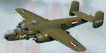
This folder contains a repaint for the North American B-25 by Roy Chaffin Studios (RCS). It shows B-25J PH-XXV "Sarinah" of the Royal Netherlands AF Historical Flight. The B-25J-20-NC SN 44-29507 now flying as "Sarinah" was accepted by the USAAF on September 28, 1944 and delivered on September 30, 1944. She departed the same day to Moody Field, Georgia. The TB-25J trainer-bomber came on duty with 2144 Base Unit, ATC starting October 7, 1944. During her Air Force career, she amassed nearly 6200 flight hours. In July of 1959, she was sold to Fogle Aircraft in Tucson, Arizona. Her civil registration was assigned as N3698G at that time. In November of 1959 she was sold to Aero Enterprises in Elkhart, Indiana. In March of 1962 she was sold to Verco Tropical Fisheries in Columbus, Ohio. She was converted to carry cargo in bomb bay and waist area in December of 1962. She was then sold in February of 1966 to Robert R. Johnson from Ft. Lauderdale, Florida. In November 1968, she was owned by Austin Williams. Sold again in July 1972 to Ernest G. Trapaga from Redondo Beach, California. In September of 1974 she was purchased by I. N. Burchinal of Paris, Texas. Then, in September of 1979 she was sold to Robert Wingate, then back to Burchinal in November who sold her to Reyline Aviation from Kissimmee, Florida. In June 1981 she was sold to Donald Webber of Baton Rouge, Louisiana. She flew as "Cochise". In December of 1989 she was sold to AMHO Corp from Wilmington Delaware and the registration was changed (in 1990) to N320SQ (representing the Dutch B-25 Mitchell 320 squadron). She was then ferried to Eindhoven, the Netherlands May 22-25 1990. The bomber was operated by the Duke of Brabant Air Force (DBAF) at Eindhoven Airport, Netherlands, who owned the bomber since 1996. From 1990 to 1999 she flew in RAF colors as "Lotys II". In April-May 1999 she was repainted in former ML-KNIL (NEIAF) colors and renamed "Sarinah". In 2009, her civil registration was changed to the current PH-XXV. Ownership was transferred in 2010 to the Royal Netherlands AF Historical Flight after a merger with DBAF. Repaint by Jan Kees Blom, based on the original textures by RCS.
| Filename: | North_American_B25J_PHXXV_Sarinah.zip |
| License: | Freeware |
| Added: | 25th August 2019, 17:33:20 |
| Downloads: | 122 |
| Author: | Jan Kees Blom |
| Size: | 2.5 MB |
| Category: Flight Simulator X - Scenery | |
| EGXJ - RAF Cottesmore - Rutland, England |
|
File Description:
RAF Cottesmore (ICAO EGXJ) is a former Royal Air Force station in Rutland, England, situated between Cottesmore and Market Overton.
The Stationed opened on 11 March 1938 and was used mainly for training, and the first squadrons were equipped with Vickers Wellesley aircraft, but soon converted to Fairey Battles. Later RAF Bomber Command took over the airfield, again as a training station, flying Handley Page Hampdens. These units remained in residence until a few days before the outbreak of war in 1939 when they were sent to RAF Cranfield to serve as a pool providing replacements for combat losses. Their place at Cottesmore was taken by Nos. 106 and 185 Squadrons, moving in from RAF Thornaby with Hampdens. However, with the outbreak of war, the aircraft and crews were sent to locations in the north and west, as enemy air attacks were expected over the southern half of England. As these never materialised, the Hampdens returned in the spring of 1940 and No. 185 Squadron became the Hampden operational training unit, No. 14 Operational Training Unit RAF.
RAF Cottesmore's Hampdens' first trespass into hostile airspace was a leaflet dropping operation over northern France. In October 1940, 106 Squadron moved to RAF Finningley while No. 14 OTU remained training crews for Bomber Command, its Hampdens and HP.53 Herefords being replaced by Vickers Wellingtons in 1942. Training continued for three years and three months until August 1943 when No. 14 OTU moved to RAF Market Harborough.
In early December 2009, it was announced the station would close due to funding cut-backs, in part to help pay for additional helicopters for British operations in Afghanistan.
In 2010, No. 4 Squadron RAF disbanded, with No. 20 Squadron RAF re-badging as No 4 (Reserve) Squadron.
The station became a satellite to RAF Wittering on 31 March 2011 with a civic parade and flypast to mark the disbandment of No 1 Sqn RAF, 800 NAS, 801 NAS and JFH.
In July 2011 Defence Secretary Liam Fox announced plans for it to be the airfield for one of five of the Army's Multi-Role Brigades. In April 2012 it was renamed Kendrew Barracks after Major General Sir Douglas Kendrew.
Source: Wikipedia
| Filename: | EGXJ__RAF_Cottesmore__Rutland_England.zip |
| License: | Freeware |
| Added: | 19th March 2016, 12:15:07 |
| Downloads: | 344 |
| Author: | Terry Boissel |
| Size: | 1.66 MB |
| Category: Prepar3D V1-4 - Utilities | |
| Flightplan Visualizer 1.15 |
|
Images related to this file:
File Description:
Flightplan Visualizer (FV) version 1.15.0. Copyright 2018-2020 by Pelle F. S. Liljendal ([email protected]), all rights reserved.
FV comes with 738 pre-imported Commercial AI flightplans (+380 BizJet flightplans are available as a separate download). However you are able to import additional (AI) flightplans yourself. Once imported these (AI) flightplans can be visualized on a map-view, and the user will be able to search accross all these. Hence you can use the program as inspiration as to which routes to fly. E.g. you can search across all imported flightplans to find all flights in an A321 flying into/out from LDDU, or simply to look for all flights in a Boeing 747-8F.
Simply run the included installer to install the software. The program will be installed into "C:\Program Files (x86)\Flightplan Visualizer" and all datafiles will be installed into: "C:\Users\[UserName]\AppData\Roaming\FlightplanVisualizer". The program comes with a full manual explaining everything, and a 3 page quick manual to get you started. The first 3 times you run the program the quick manual will automatically open. The forum is hosted here: https://forum.aerosoft.com/index.php?/forum/919-flightplan-visualizer/
Version 1.15 Contains the following changes:
- As a first, you can now import flightplans even if one or more aircraft-types cannot be automatically detected during import. These will instead be assigned to a dummy-type during import, however you need to manually assign substitute aircraft-type(s) before being able to save the imported flightplan. If/when the program gets support for the aircraft-type(s) that were missing during import, the substitute aircraft-types can either be re-detected manually or by using the "Re-process aircraft/airport-redirects" menu-item.
- Added a combo-box that can be used to filter the flightplans that are shown in the flightplan combo-box on the main-form (e.g. enter "west" to see only flightplans containing "west" in the name). Hovering the mouse over this new filter combo-box will show examples of the more complex filters (e.g. filter by provider, author, season, year, and so on).
- In version 1.14 user-airlines were added, and these could be accessed via a menu-item on the main-form. However in version 1.15 you can now also add user-airlines from the import-flightplan form, so you don't have to abort a pending import, and go to the main form in case you find you are missing a user-airline.
- Added MRU-lists (Most Recent Used) to the browser-forms used to search for: Airport, Aircraft and Airline. The text-edit in the top of these forms have been replaced by a combo-box holding up to 20 items (in chronological order, with the most recent at the top).
- Added a new chart to the Airport Info form showing: "Daily flights per international/domestic/same state".
- Added Utilization-pct to the fleet report (both total for the entire fleet, and per aircraft). The Utilization-pct is also visible for the displayed schedule (for a single aircraft) in the Leg-Info form. This value tells the pct of time the aircraft spends servicing the schedule (the remaining time the aircraft "sits at the gate", including the time spend loading/unloading passenger and cargo, loading fuel, being serviced by ground-crew and what not).
- On the main-form, renamed menu-item "Re-process airport-redirects" into "Re-process flightplans".
- Distance from selected airport to mouse-position on main-map moved from the bottom of the form to the upper/right-corner of the form (where info of selected airport is listed).
- Using the (right-click) context-menu on the main-form airports can now be toggled (on/off) as being favorites.
- A few minor changes were made to the default leg search criteria. If you have saved your own default, you should go to the leg search form, press-and-hold SHIFT while clicking the "Reset" button (to reset to "factory default"), then set the criteria to your perferences, and finally press the "Save Reset" button to re-save your preferences.
- Added MRU-list (Most Recent Used) to fuel-density combo-box on Unit Conversion form. If empty, the list will be preloaded with the values 0.7850 (old default), 0.8040 (often used as a standard for Jet-A), 0.8200 (often used as a standard for Jet-A1). The user is still able to enter another value.
- The values used in the unit-conversion form are saved with the settings file, so each time you open the form will contain the values entered last time you used the form.
- Tweaked the method for calculated flight-time. In previous version the same parameters were used for calculating flight-time for all flights. Now these parameters are dependant on distance, resulting in calculated flight times that are closer to those used in the flight-plans (based on statistic-data from +700.000 AI flights).
- Some of the aircraft have been marked as "Retro", and in settings you can choose to exclude the "Retro" (they are enabled by default).
- Improved (Boeing) aircraft-type detection when importing flightplans using non-standard naming, such as "B744F" in stead of "747-400F" or "B736" in stead of "737-600".
- Updated all libraries in use to the latest versions, and addressed some minor issues with the map.
- Fixed: Newer versions of MyRwy are outputting airport elevation as a floating point value (e.g. "629.92") whereas older versions were outputting it as an integer value (e.g. "630"). In previous versions of FV the floating point value "629.92" was wrongly read as an elevation of 62992 ft. The program can now both handle floating point and integer values, hence can be used with both old- and new versions of MkRwy.
- Fixed: When adding new user-airlines in version 1.14, callsign was being set to the name of the airline, in stead of the entered callsign. If you added any user-airlines in version 1.14, you should edit these with version 1.15, and set the callsigns again.
- Fixed: If a Leg search was active (combo-box in bottom of main-form showing "[Last Search]") and all flightplans were disabled in "Enable/Disable -flightplans" the program would shut-down with an exception.
- Fixed: The list of the airline-codes (gate-tab on Airline-Info form) started with a comma, however comma should only be used to separate the items when multiple airline-codes were associated with the same gate (3rd party scenery only).
- Fixed: In some cases the cruise-speed was not shown correctly in the Aircraft search form.
- Fixed: Some of the menu-items for launching the (YouTube) tutorial-videos were missing the tool-tip text ("Hold SHIFT to copy url to clipboard").
- Fixed: About-box can now be closed with ESC, like most other forms.
- Fixed: potential issue reading xml-data, perhaps with a the benefit of a slightly better performance.
- Data: Added support for flightplans using "retro" aircraft types such as: Aerospatiale SE-210 Caravelle, British Aerosapce ATP/BAC One Eleven, Concorde, DC-3, DC-4, DC-6, DC-8, De Havilland Comet, Fokker F28, Hawker Siddeley HS 121 Trident, Ilyushin Il-18/20/22/24/86, Lockheed Constellation/L-188 Electra, Shorts SC-5, Tupolev TU-134, Vickers VC10/Viscount, and thanks to user Aucery Lockheed 1011.
- Data: Support for additional aircraft-types added as well: BN-2A Trislander, CASA C-212/C-235, CubCrafters XCub, DHC-2 Beaver/Turbo-Beaver, DHC-3 Otter, DHC-5 Buffalo, Diamond DA-42/62, Extra EA-300, Honda HA-420, ICON A5, NAMC YS-11, Mooney, Mudry CAP 10, Pilatus PC-6/PC-24, Piper Cub/Super Cub, Robin DR-300/400, Shorts SC-7, Tecnam P2012/P2006T
- Data: Some of the aircraft-types, for which multiple ICAO/IATA-codes exists, were split into two (one for Pax and one for Freight), e.g. Convair 580, DC-9-10/30/40, and Il-96. As a result you should execute "Re-process flightplans" (found in the "Flightplan" menu), and "Re-detect all" aircraft.
- Data: A few missing aircraft IATA/ICAO codes were added, and some "behind the screen" data for multiple aircraft were updated as well.
- Data: A few Airlines were added/updated (a big THANK YOU to Bruce Nicholson for the assistance keeping these data up-to-date).
- Flightplans: The good people over at AIG (Alpha India Group) have once again been VERY busy since the last release, hence the installer comes with 298 new/updated pre-imported flightplans, bringing the total of flightplans bundled with the installer to 738.
- Flightplans: A few flightplans were bundled with the program in duplicates (2 slightly different names, or 2 different seasons). These duplicates have been marked as obsolete, and have been removed from the installer. Using the "Select all obsolete flightplans" menu-item in "Enable/disable-flightplans" you can mark these flightplans and move them to the "Disabled" folder, from where they can be deleted.
Pelle
| Filename: | Flightplan_Visualizer_115.zip |
| License: | Freeware, limited distribution |
| Added: | 20th March 2020, 17:08:52 |
| Downloads: | 378 |
| Author: | Pelle Liljendal |
| Size: | 28.9 MB |
| Category: Flight Simulator 2004 - Original Aircraft | |
| North American T6_Harvard |
|
Images related to this file:
File Description:
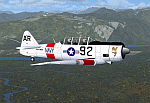
North American T6_Harvard
This aircraft has has been constructed using Gmax v1.2. The aircraft is constructed with as few polygons as possible and with a single texture file to ensure the absolute minimum impact on your framerates. There are two models- each has seven LODs.
The aircraft has had an amazing history with first prototype flying in 1935. To quote from Wikipedia "A total of 15,495 T-6s of all variants were built.During the Korean War and to a lesser extent, the Vietnam war, T-6s were pressed into service as forward air control aircraft. These aircraft were designated T-6 "Mosquito"s.[1] The RAF used the Harvard in Kenya against the Mau Mau in the 1950s where they operated with 20 lb bombs and machine guns against the gangs. Some operations took place at altitudes around 20,000 ft asl. A Harvard was the longest-serving RAF aeroplane, with an example, taken on strength in 1945, still serving in the 1990s (as a chase plane for helicopter test flights - a role the Shorts Tucano's high stall speed was ill-suited for). The T-6G was also used in a light attack or counter insurgency role by France during the Algerian war in special Escadrilles d'Aviation L�������©g�������¨re d'Appui (EALA), armed with machine guns, bombs and rockets. At its peak there were 38 EALA's active. The largest unit was the Groupe d'Aviation L�������©g�������¨re d'Appui 72, which consisted of up to 21 EALAs. Portugal also used ex-French aircraft during the Portuguese Colonial War.
Since the Second World War, the T-6 has been a regular participant at air shows, and was used in many movies. For example, in Tora! Tora! Tora! and The Final Countdown, converted single-seat T-6s painted in Japanese markings represent Mitsubishi Zeroes. The New Zealand Warbirds "Roaring 40s" aerobatic team use ex-Royal New Zealand Air Force Harvards. The Reno National Air Races also has a class specifically for the T-6 during the National Air Races each year."
This GMax model is quite fun to fly as a normal aircraft, but was originally designed specifically to enhance the AI aircraft population.
I would like to especially thank Ray Blake who has kindly made these high quality textures for this package.
A paintkit is being posted as a separate zip file.
| Filename: | North_American_T6_Harvard.zip |
| License: | Freeware, limited distribution |
| Added: | 3rd December 2009, 19:01:27 |
| Downloads: | 1,573 |
| Author: | Mike Cronin - aircraft and paintkit; Ray Blake - textures |
| Size: | 1.78 MB |
| Category: Flight Simulator X - Aircraft Repaints, Textures and Modifications | |
| air algerie livery of wilco a340-300 |
|
File Description:
air algerie leased an a340-300 from hifly
The Airbus A340 is a long-range, wide-body passenger airliner that was developed and produced by Airbus. In the mid-1970s, Airbus conceived several derivatives of the A300, its first airliner, and developed the A340 quadjet in parallel with the A330 twinjet. In June 1987, Airbus launched both designs with their first orders and the A340-300 took its maiden flight on 25 October 1991. It was certified along with the A340-200 on 22 December 1992 and both versions entered service in March 1993 with launch customers Lufthansa and Air France. The larger A340-500/600 were launched on 8 December 1997; the A340-600 flew for the first time on 23 April 2001 and entered service on 1 August 2002.
Keeping the eight-abreast economy cross-section of the A300, the early A340-200/300 has a similar airframe to the A330. Differences include four 151 kN (34,000 lbf) CFM56s instead of two high-thrust turbofans to bypass ETOPS restrictions on trans-oceanic routes, and a three-leg main landing gear instead of two for a heavier 276 t (608,000 lb) MTOW. Both airliners have fly-by-wire controls, which was first introduced on the A320, as well as a similar glass cockpit. The later A340-500/600 have a larger wing and are powered by 275 kN (62,000 lbf) Rolls-Royce Trent 500 for a heavier 380 t (840,000 lb) MTOW.
The shortest A340-200 measured 59.4 m (195 ft), and could cover 12,400 km / 6,700 nmi with 210–250 seats in 3-class. The most common A340-300 reached 63.7 m (209 ft) to accommodate 250–290 passengers and had a 13,500 km / 7,300 nmi range. The A340-500 was 67.9 m (223 ft) long to seat 270–310 over 16,670 km / 9,000 nmi, the longest-range airliner at the time. The longest A340-600 was stretched to 75.4 m (247 ft), then the longest airliner, to accommodate 320–370 passengers over 14,450 km / 7,800 nmi.
As improving engine reliability allowed ETOPS operations for almost all routes, more economical twinjets have replaced quadjets on many routes. On 10 November 2011, Airbus announced that the production reached its end, after 380 orders had been placed and 377 delivered from Toulouse, France. By the end of 2021, the global A340 fleet had completed more than 2.5 million flights over 20 million block hours and carried over 600 million passengers with no fatalities. The A350 is its successor; the McDonnell Douglas MD-11 and the Boeing 777 were its main competitors. Lufthansa is the largest operator and the largest customer with 34 A340 aircraft in its fleet.
| Filename: | air_algerie_livery_of_wilco_a340300.zip |
| License: | Freeware |
| Added: | 29th May 2022, 17:02:17 |
| Downloads: | 166 |
| Author: | moussa cherif baya |
| Size: | 10.55 MB |
| Category: Flight Simulator X - Scenery | |
| GB-0112 - RAF Bassingbourn - Cambridgeshire, England |
|
File Description:
RAF Bassingbourn is a former Royal Air Force station located in Cambridgeshire approximately 3 mi (5 km) north of Royston, Hertfordshire and 11 mi (18 km) south west of Cambridge, Cambridgeshire, England.
RAF Bassingbourn was constructed by John Laing & Son between 1937 and 1939 in the parishes of Wendy and Bassingbourn immediately to the west of the A14 (now the A1198) road. The site selected was low ground between several tributaries of the River Cam. The area had been long cleared of forest and tended to be swampy and unstable, and because the boggy ground produced a persistent mist over the large meadow the site was considered ideal for airfield camouflage.
During the Second World War it served first as an RAF station and then as a bomber airfield of the Eighth Air Force, of the United States Army Air Forces (USAAF). It remains the home of the Tower Museum Bassingbourn. From 19 August 1942 to 25 June 1945, Bassingbourn served as headquarters for the 1st Combat Bombardment Wing of the 1st Bomb Division. It was assigned USAAF designation Station 121.
The RAF resumed occupation of Bassingbourn on 26 June 1945, the airfield was officially returned on 10 July 1945. The station became one of the main airfields for long-range transport aircraft. In 1948 and 1949 Avro York, Avro Lancaster and Douglas Dakota aircraft from the base took part in the Berlin Airlift, a massive operation transporting essential commodities to the beleaguered city.
In February 1952, RAF Bassingbourn received its first allocation of English Electric Canberra bombers and became the first jet bomber operational conversion unit (OCU) in the world. Canberras operated from Bassingbourn for 17 years and one of the aircraft is on static display in the Barracks. From 1963 to 1969 the Joint School of Photographic Interpretation was also located there.
On 29 August 1969, the last RAF Commanding Officer, Sqn Ldr A.M. McGregor MBE, turned over the station to the British Army as Bassingbourn Barracks.
The barracks were established, on the site of the former RAF Bassingbourn airfield, in January 1970, as the new Depot for the Queen's Division. The depot was responsible for training recruits undergoing their 19-week basic training before joining a regular battalion; in 1993 the Barracks were re-designated the home of the "Army Training Regiment, Bassingbourn" and remained as such for nearly 20 years. Bassingbourn Barracks closed as an army training location in August 2012.
The site was reopened for training Libyan soldiers in 2014 but closed down the same year.
Since approximately 1970 the site has retained its RAF links by being the home of 2484 (Bassingbourn) Squadron Air Training Corps.
| Filename: | GB0112__RAF_Bassingbourn__Cambridgeshire_England.zip |
| License: | Freeware |
| Added: | 30th May 2016, 11:01:25 |
| Downloads: | 321 |
| Author: | Terry Boissel |
| Size: | 1.58 MB |
| Category: Flight Simulator 2004 - Scenery | |
| FS9 Fort St John CYXJ in BC Canada |
|
File Description:
Fort St John is close to the border between British Columbia and Alberta, around 40 miles north-northwest of Dawson Creek. The airport was originally a Royal Canadian Air Force base, associated with the wartime construction of the Alaska Highway. The airfield was part of this construction effort and the wartime ferrying of planes to Russia. It is currently named "North Peace Regional Airport", or "North Peace Airport"; apparently there has been no final decision?
The date for this scenery is around 2006. I was given an old video tape cassette which was filmed on an uncertain date, but which had to be before the terminal building was renovated in 2007 and totally changed in appearance. The only way to view the video was to play it in the camera and watch it on a small screen. After I had completed everything except the buildings I started to view the video to establish the building appearances and within an hour or so the camera died. It was so old there was no way to repair it, so I then made some new buildings from memory of the video and what was available online. I also used some that I had already made for other scenery but which were similar. I may replace the terminal building that is in this version with a build of the new one, as I know this one is not a very accurate reproduction. The replacement, if I do it, will be towards the end of this year.
The AI included here is for GA, Air Canada Jazz, and two helicopter companies that were (and still are?) based there. One is at the western end of the apron and the other is at the eastern end but separated from the apron. To gain access to the taxiways and runways (so that all airport users follow the same procedures, for safety reasons) the eastern end helicopters just taxi across the grass. The helicopters are used for maintenance trips to the oil and gas fields in the surrounding area. My screenshots show Westjet at the terminal; this is because I have later Canadian AI installed, while the AI included here is only for the time around 2000 to 2010, when Westjet were not flying to Fort St John.
The airport is square in plan, with the apron running along the northern side and two runways forming diagonals. The two runways are 11-29 (6,882 feet long and 200 feet wide, with ILS at the 29 end and PAPI at the other) and 02-20 (6,684 feet long and 200 feet wide, and with PAPI at each end). The eastern side taxiway that runs north-south is not used. The western side taxiway is in use but only as a race track for cars.
Please email me if you find faults, such as a plane without textures.
| Filename: | FS9_Fort_St_John_CYXJ_in_BC_Canada.zip |
| License: | Freeware, limited distribution |
| Added: | 10th October 2022, 14:03:38 |
| Downloads: | 214 |
| Author: | Roger Wensley |
| Size: | 37.49 MB |
| Category: Flight Simulator X - Scenery | |
| RAF Elvington |
|
File Description:
The station was originally a grass airfield within No. 4 Group. In the early 1940s the airfield was entirely reconstructed with three hardened runways replacing the grass. It re-opened in October 1942 as a station for 77 Squadron RAF and along with RAF Melbourne and RAF Pocklington was known as No "42 Base". The squadron had a strength of approximately 20 aircraft and initially used the twin engined Armstrong Whitworth Whitley medium bomber although this was quickly replaced by the Handley Page Halifax four engined heavy bomber which was being introduced. No 77 Squadron suffered heavy losses during its time at Elvington with over 500 aircrew killed, missing or taken prisoner and almost 80 Halifaxes lost as it played a major part in the Battle of the Ruhr and the bombing of Berlin.
In May 1944 No 77 Squadron posted to the newly opened nearby RAF Full Sutton and was replaced at Elvington by two French squadrons, numbers 346 "Guyenne" and 347 "Tunisie" who both played a leading part in the bombing of Germany. Elvington was the only airfield in the United Kingdom used by the remainder of the Free French Forces, they also flew Handley Page Halifax heavy bombers until they moved to Bordeaux in October 1945 where they became the basis for the new air force of liberated France. In September 1957 a memorial was unveiled in Elvington village dedicated to the two French squadrons. While they were at RAF Elvington nearly half of the squadrons' members were killed.
After the war the 400-acre (1.6 km2) airfield was transferred to No 40 Group under the control of Maintenance Command until 1952 when it was greatly enlarged and extended for use by the United States Air Force.
United States Air Force use
The United States Air Force (USAF) built a new 3,094 m (10,151 ft) runway, which was the longest in the north of England, and a huge 19.8 hectares (49 acres) rectangular hardstanding apron as well as a new control tower to turn Elvington into a "Basic Operation Platform" which would have operated as a Strategic Air Command (SAC) dispersal airfield. After spending £4 million the airfield never became operational as a SAC base and was abandoned by the US Air Force in 1958.
Other uses
In the early 1960s the Blackburn Aircraft Company, now part of British Aerospace used the runway for test flights of the Blackburn Buccaneer. Elvington retained its status as an RAF relief landing ground and was used by the RAF flying training schools at RAF Church Fenton and RAF Linton-on-Ouse until the airfield was finally closed in March 1992.
Present day
The airfield is now owned by Elvington Park Ltd. The adjacent buildings and control tower have been restored, and serve as the Yorkshire Air Museum which has many varied and rare aircraft and exhibits, including a complete Halifax bomber. Elvington is also a popular motorsports venue for motorcycle racing.
Source:Wikipedia
| Filename: | RAF_Elvington.zip |
| License: | Freeware |
| Added: | 10th April 2017, 22:08:13 |
| Downloads: | 167 |
| Author: | Terry Boissel |
| Size: | 220.79 KB |
| Category: Flight Simulator 2004 - Scenery | |
| Ketchikan PAKT in southern Alaska plus float planes 5KE and the town |
|
Images related to this file:
File Description:
This is Ketchikan PAKT in southern Alaska, 45 miles north of the Canadian border and 220 miles south of Juneau. It is the closest major Alaskan airport to the lower 48 and most flights from or to Seattle pass through Ketchikan en route. The airport is on the southern side of the stretch of water known as The Narrows and the town is on the northern side, with ferries connecting the two. The town side was somewhat modified as part of one of the three Misty Fjords sceneries, so there were already some marinas and docked cruise liners etc before I started this. In addition, Ketchikan Airport had been partly made way back in 2006, and further modified in 2007; I say "partly" as there is in fact no way to accurately make PAKT within the limitations of FS9 as there is a 50 or 60 feet difference in elevation between runway and apron, and the taxiways are actually ramps up from the apron to the ends of the runway. This has a knock-on effect on the float plane and ferry docks on the water below the airport. I can see why the Misty Fjord sceneries avoided it. This scenery retains the original buildings from the Alan Wright scenery. It also includes the modification made by John Hinson, who created the second taxiway to the western end of the runway; FS9 had not included this as the original airport started operations with only one taxiway in place. There are new vehicles on the apron (fuel etc), new apron markings and some parking modifications to enable AI with Boing 737, DC6, Beechcraft 1900, and GA, plus runway and taxiway signage, windsocks, some car parking, freight items, etc. There is a road and covered bridges down to the docks and ferry, and the town side of the water has been modelled to include other float plane docks along with waterfront buildings, including the ship repair facility with it's dry dock (actually a floating dock that lifts ships out of the water) and the Alaskan Ferry Terminal wharf etc. The ferry forms a part of the AI, generously permitted by FSAddon and originally a part of the payware Tongass Fjords package, as are the AI aircraft also included here. There are new waterside buildings that stretch from the ship repair yard, past the shopping plaza and onward to the stationary cruise liners (that were part of the Tongass payware scenery) including float docks for the float plane companies that are based in Ketchikan, plus a new AI liner. The AI is a further adaptation of the already posted CF36 AI and PAKN AI, as listed in the AI folder. Due to the surrounding hills there may be some interference with AI float aircraft, depending on the wind direction, though I have watched succesful Beaver landings with the wind from the east. The combined AI for float planes creates a float plane take off or landing at, on average, 20 minute intervals; this is still well short of the actual busy summertime period.
| Filename: | Ketchikan_PAKT_in_southern_Alaska_plus_float_plane.zip |
| License: | Freeware, limited distribution |
| Added: | 12th February 2017, 23:27:59 |
| Downloads: | 1,239 |
| Author: | Roger Wensley |
| Size: | 47.11 MB |
| Category: Flight Simulator 2004 - Scenery | |
| Stephenville CYJT in Newfoundland Canada |
|
Images related to this file:
File Description:
Stephenville is on the east coast of Canada, and the airport was an American base from 1941, when it was built, until 1966. It was named the "Ernest Harmon Airforce Base" and I will leave that for you to research if you wish to know more. Operating in my version (around 2010?) as a civilian airport, it's main features are a long 10,000 feet 09-27 runway (with ILS on 27) and acres of empty space. The runway was one of those designated as an emergency space shuttle landing runway if required. There is a shorter 20-02 runway (3,000 feet) that is not maintained during the winter (and which would be closed in 2018). The revised perimeter fence of the airport now encloses less than half of the original area, with the northern parts replanned as an industrial park. The attached screenshot from Google Earth shows this, and also that the main operating part of the airport is at the western end of the main runway, with only one hangar connecting to the runway from the eastern end. Like Gander, the airport is still shrinking, with taxiways and aprons not maintained (particularly in the winter) or even formally closed, and flight numbers falling. Until the early 1990's Stephenville was serving most of western Newfoundland and Air Canada, for instance, was one of the airlines that flew there. Deer Lake took over this task for western Newfoundland when the Provincial Government so decided. Stephenville remains as a port of entry, and planes with a total of 30 or less passengers can still be serviced there. My version is a mixture that cannot be precisely dated. For instance, I know there was a large hangar there until 2013 but as I do not have any photos to make it I have shown only the concrete square where it formerly stood. So 2008 or 2013, or somewhere in between? I have the airport being served by Provincial Airlines and also by Porter, though in fact Porter only flew there during the Summer months; I say "flew" as right now all flights are of course almost totally non-existent. As with Gander, I have made it clear which of the taxiways and aprons are still in regular use by showing them as asphalt, while those in the process of decaying disuse or removal are in the darker gravel or tarmac textures; this is somewhat realistic as when asphalt aprons are "ploughed" for removal the darker underside becomes visible. I have also shown the areas that now form part of the Industrial Park as cement, as this better matches the Ultimate Terrain road texture. It may seem odd that the new Canadian Coastguard hangar is not properly served by an asphalt taxiway instead of sitting on an apron that is not cleared in the winter, but it caters (mainly?) for helicopters. The original coastguard hangar is the large and decrepit one in the northeastern corner of the airport. Almost all of the buildings within the original perimeter of the airport are fairly accurately replicated here, whether still in use (Road Maintenance Department, Garbage Disposal, Armour Trucking Company, etc) or vacant (including the very strange atom-bomb-proof buried shelter) or still part of the airport (the east side of the main apron with Shell to the north, then the terminal, the Marine Institute, etc). The AI included here (a revised Gander AI) is for daily flights by Provincial Airlines, Porter, and some charter planes and GA. You will see, once the scenery is installed, that like Gander there two scenery folders called "Scenery summer" and "Scenery winter". Obviously in August you will want the summer scenery and you get this by editing the folder name down from "scenery summer" to just "scenery" and FS9 loads the summer ground textures. If FS9 decides that there is snow on the ground then you need the winter textures which do not show the aprons or taxiways that do not receive winter maintenance. One thing you must NOT DO is to edit both folders down at the same time.
| Filename: | Stephenville_CYJT_in_Newfoundland_Canada.zip |
| License: | Freeware, limited distribution |
| Added: | 24th June 2020, 18:01:58 |
| Downloads: | 235 |
| Author: | Roger Wensley |
| Size: | 43.78 MB |


© 2001-2026 AVSIM Online
All Rights Reserved
Privacy Policy |