
Where Flight Simulation Enthusiasts Gather from Around the World!
AVSIM Library - Search Results

| Category: Flight Simulator X - Aircraft Repaints, Textures and Modifications | |
| North American P-51D Mustang "Hell-er Bust" |

|
Images related to this file:
File Description:
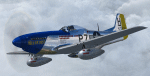
A repaint only for the payware Warbirdsim product 'Mustang Tales'. This repaint depicts the restored P-51D-20-NA 44-72438, "Hell-er Bust", registered N7551T. This specific aircraft is known to have been delivered to the 8th Air Force in England in late January 1945, however no available records indicate any combat time or what, if any, Fighter Group the aircraft was assigned. Following the end of WWII the aircraft served with the Swedish AF as Fv26131, and then with the Dominican AF as FAD 1920. After being imported back into the U.S. in the 1980's, the aircraft was purchased by Selby Burch and given a ground-up restoration. Finished in 118th TRS markings, the aircraft won the Grand Champion WWII Warbird award at Sun 'N Fun 1997. The aircraft was later purchased by Bob Jepson/Lady Alice Corporation and first repainted as 'Lady Alice' and then as 'Hell-er Bust'. In 2006 the aircraft was obtained by the Historic Aircraft Foundation and based at Paine Field, near Seattle, WA. Since 2009, the aircraft has been owned by Mark Peterson/Mustang High Flight LLC, based at Boise, Idaho, and remains finished as 'Hell-er Bust'. The markings depict an original wartime mount of Lt. Col. Edwin L. 'Ed' Heller, a P-51D-10-NA (44-14696) of the 486th FS, 352nd FG. This repaint features new bump maps, wheel well, gun bay, and cockpit textures.
| Filename: | North_American_P51D_Mustang_Heller_Bust.zip |
| License: | Freeware |
| Added: | 14th April 2013, 21:42:25 |
| Downloads: | 215 |
| Author: | John Terrell |
| Size: | 25.84 MB |
| Category: Flight Simulator 2004 - Flight Plans | |
| Military Base Tour - South Asia |
|
File Description:
“Military Base Tour – South Asia” (MFSA) continues the MILITARY FLIGHTS SERIES which includes “Military Flight Plans” (MF), “Military Flight Plans – Europe” (MFE) and “Military Base Tour – West Asia” (MFWA). In this segment there are 20 new flight plans in South Asia, starting in Kuwait, and moving on through India, Sri Lanka, Diego Garcia, Bangladesh, Bhutan, Myanmar, Thailand, Vietnam, Cambodia and ending in Singapore. The landing and takeoff at Paro, Bhutan is particularly memorable. A complete Flight Briefing is provided for each flight. Also included are a MFSA ITINERARY and a “Military Flights Master Itinerary” which lists each flight in all four segments of the Series to date. There are a total of 87 flight plans, starting in the US, going down through Cuba & Central America, back to the US and Canada, and then over to Europe, West Asia and now this South Asia segment. The final segment, “Military Base Tour – Pacific Rim” is under construction and will return the series to Andrews in Washington D.C. and make the SERIES a “Round the World” trip. It is suggested that the pilot set up a new file Folder (or file in an existing Folder) to unzip the file “mfsa_flights.zip” to and store the .PLN and Flight Briefing files. The .PLN file can then be copied to the “Flight Simulator Files” to set up the flight, and the briefings printed and available for quick reference during the flight.
| Filename: | Military_Base_Tour__South_Asia.zip |
| License: | Freeware |
| Added: | 20th November 2004, 00:07:13 |
| Downloads: | 1,747 |
| Author: | John Resch |
| Size: | 232.89 KB |
| Category: Flight Simulator 2004 - Scenery | |
| Sisimiut (BGSS) on the west coast of Greenland |
|
Images related to this file:
File Description:
Sisimiut is on the west coast of Greenland. It is around 125 miles south of Aasiaat, and 80 miles west of Kangerlussuaq airport, which is currently the largest commercial airfield in Greenland. Sisimiut has a population of 5,500 and the main occupations are fishing, tourism, education, and a growing industrial base. It has the northernmost year-round ice-free port in Greenland, though icebergs floating down from the north are commonplace. The airport is across a bridge and along a two mile road on the north side of an inlet, northwest of the town. The runway is 2,600+ feet of asphalt almost 100 feet wide and lit, aligned 20/02 and at 33 feet ASL, with the apron and terminal building at the eastern end. The building is identical to the one at Aasiaat. Air Greenland run regular flights with a Dash-8, Dash-7, or Twin Otters; within FS9 it is impossible to land an Ai Dash-7 on a runway less than 3,000 feet long, so I used a Dash-8. There was no way to replicate both the parking facing away from the terminal AND the "through" taxiing to complete the circle back to the runway; after parking correctly the AI Air Greenland plane will reverse before heading out to take off. The surrounding area is rock with some scruffy grass and low bushes, and there is no grass around the runway; the airfield has compacted gravel instead.
| Filename: | Sisimiut_BGSS_on_the_west_coast_of_Greenland.zip |
| License: | Freeware, limited distribution |
| Added: | 28th April 2012, 22:03:35 |
| Downloads: | 853 |
| Author: | Roger Wensley |
| Size: | 3.71 MB |
| Category: Flight Simulator X - Scenery | |
| GABS Bamako Senou International Airport |
|
File Description:
Bamako Senou International Airport (IATA: BKO, ICAO: GABS) is Malis main airport approximately 15 km south of downtown Bamako, the capital of Mali in West Africa. It is managed by Aeroports du Mali (ADM). Its operations are overseen
by the Malian Ministry of Equipment and Transports. Senou Airport was opened to traffic in 1974. The airport was upgraded between 2007 and 2012 in a 181 million US dollar project funded by the Millennium Challenge Corporation, a United
States foreign aid agency. Passenger traffic steadily increased in the early 2000s. Government figures show 403,380 passengers in 1999, 423,506 in 2003, 486,526 in 2004, and 516,000 in 2005. It is predicted to reach over 900,000 by 2015
under a low (4%) yearly growth rate scenario.
To date this growth rate has been surpassed. Total air traffic at BKO increased by 12.4% in 2007 and 14% in 2008. Most of this increase came in passenger transport, with the number of passengers served increasing by 20% in 2007 and 17%
in 2008. Twenty-seven airline carriers operated weekly or better at BKO in the 2007-2008 period. This continued growth was offset by cargo flights decline of 16.75% in 2007, and 3.93% in 2008.
The highest frequency route is on the Bamako-Dakar sector with 29 weekly non-stop connections. Domestic flights also serve Mali's regional capitals Kayes, Mopti, Timbuktu, Sikasso, Gao, and Kidal.
This work is dedicated to West Wind Airlines.
| Filename: | GABS_Bamako_Senou_International_Airport.zip |
| License: | Freeware |
| Added: | 27th March 2013, 01:12:43 |
| Downloads: | 3,401 |
| Author: | Anwar Gonzalez |
| Size: | 915.65 KB |
| Category: Flight Simulator 2004 - Scenery | |
| Amundsen-Scott Station |
|
File Description:
The Amundsen-Scott South Pole Station is the American scientific research station on the high plateau of Antarctica. This station is located at the southernmost place on the Earth, the Geographic South Pole, at an elevation of 2,835 meters (9301 feet) above sea level.
Since the Amundsen-Scott Station is located at the South Pole, it is at the only place on the land surface of the Earth where the sun is continuously up for six months and then continuously down for six months. (The only other such place is at the North Pole, on the sea ice in the middle of the Arctic Ocean.) Thus, during each year, this station experiences one extremely long "day" and one extremely long "night". During the six-month "day", the angle of elevation of the Sun above the horizon varies continuously. The sun rises on the September equinox, reaches its maximum angle above the horizon on the summer solstice in the Southern Hemisphere, around 20 December, and sets onthe March equinox.
During the six-month "night", it gets extremely cold at the South Pole, with air temperatures sometimes dropping below -73 C (-100 F). This is also the time of the year when blizzards, sometimes with gale-force winds, strike the Amundsen-Scott Station. The continuous period of darkness and dry atmosphere make the station an excellent place from which to make astronomical observations.
This file has the apron and characteristics of the airport the coordenates are placed as far south FS allow it.
| Filename: | AmundsenScott_Station.zip |
| License: | Freeware |
| Added: | 17th October 2011, 22:02:39 |
| Downloads: | 671 |
| Author: | Anwar Gonzalez |
| Size: | 5.92 KB |
| Category: Miscellaneous Files - Miscellaneous Files | |
| 79C - Brennand Airport - Neenah, Wisconsin - USA |
|
Images related to this file:
File Description:
Well this is my 1st attempt at creating/editing an airport so be gentle. I created all the models in sketchup and used ADE to compile the airport. All you should have to do is unzip it and place it with your other add-on scenery and activate it in P3D. This is for P3D V2 only at the moment. When I get a chance I'll get an FSX version done if anyone wants it.
Brennand Airport (79C) located about 4 miles southwest of Neenah WI. This airport is between KATW and KOSH. Brennand has had new ownership since 2013 and they have made many improvements in that time to 79C. So I went out there and took lots of pictures to create what I have for us now. They have built a new building and hangar which I have added along with all the other building on the airport grounds. The runway has been widened from 20 feet to 30 feet and they added PAPI lights on both runways 18 and 36 all of which I have included. I have changed the grass parking areas to reflect the way they are currently set up. (For fun parking area 8 is in the EAA Chapter 41 hangar (Hangar 11) with the door open so you can taxi out of the hangar. Now just need to figure out how to animate the hangar door).
Compatible with P3D v2 ONLY. FSX version may follow later.
| Filename: | 79C__Brennand_Airport__Neenah_Wisconsin__USA.zip |
| License: | Freeware |
| Added: | 4th November 2014, 00:05:41 |
| Downloads: | 99 |
| Author: | Jon Verrett |
| Size: | 32.63 MB |
| Category: Flight Simulator 2004 - Original Aircraft | |
| AerMacchi C.205 VELTRO (Greyhound) |
|
Images related to this file:
File Description:
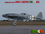
The Macchi C.205 (also known as MC.205,"MC" standing for "Macchi Castoldi") Veltro (Italian:Greyhound) was an Italian World War II fighter aircraft built by the Aeronautica Macchi.
The C.205 was a development of the earlier C.202 Folgore. With a top speed of some 400 mph and equipped with a pair of 20 mm cannon as well as 12.7 mm Breda machine guns, the Macchi C.205 Veltro was highly respected by Allied and Luftwaffe pilots alike. Regarded as the best Italian aircraft of World War II, in action it proved to be extremely effective, destroying a large number of Allied bombers and capable of successfully clashing on equal terms with such renowned fighters as the North American P-51D Mustang, but, although the C.205 was able to match the best Allied opponents in speed and manoeuvrability, it was introduced late in the conflict. Moreover, due to the poor Italian industrial capability of the time, only a small production run was delivered before the end of the war.
Italy's highest scoring ace, Adriano Visconti, achieved 11 of his 26 credited victories in the few weeks he was able to fly the Veltro, with the top scoring 205 Sergente Maggiore pilota Luigi Gorrini shooting down 14 enemy aircraft plus six damaged with the C.205.
VC only. GMax Models and Skins by Manuele Villa & Italianwings, Flight dynamics by Manuele Villa & Kikko Zanaboni. It also works (Tested), subject to some limitations, within FSX. By Manuele Villa/MVG3D, September 2012.
| Filename: | AerMacchi_C205_VELTRO_Greyhound.zip |
| License: | Freeware, limited distribution |
| Added: | 28th September 2012, 10:56:13 |
| Downloads: | 1,260 |
| Author: | Manuele Villa, Italianwings |
| Size: | 37.96 MB |
| Category: X-Plane - Original Aircraft | |
| Boeing B314 Clipper for X-Plane 6.40/6.51 |
|
File Description:
Boeing B314 Clipper v1.0 for X-Plane 6.4/6.51- Built for Pan American Airways to expand their Clipper fleet, they also saw service for the US Navy and BOAC. The "clipper" name was appropriate because the Sikorsky S42, the Martin M130 (also available for X-Plane on AVSIM) and the Boeing B314 opened up long distance air lanes in 1930's and 40's the same way that the clipper ships opened up sea trade in the late 1800's. The model flies very well and is as accurate as the limited plans available to me. Due to limitations in shaping airfoils the outside rudders are actually engine nacelles (jets with 5 lb of thrust) and the lower wing is also an engine nacelle. The rear section of the fuselage is actually a gas tank or float section used to get better detail in the fuselage. As all of my models the exterior paint and panel can use a lot of work. What you see here is approximately 6-8 hours of modelling/decorating? work plus 16-20 hours or more of test flights.
Number built: total 12, 6 A314's built with upgraded engines and increased range
Engines: 4 - 1,600 HP, Wright R-2600, Twin Cyclone ,14 cylinder, air-cooled, radial engines. Wing Span: 152 ft. Length: 106 ft Max GW: 84,000 lb. Max level speed: 193 mph Cruising speed: 183 mph Range: 3,500 (5,200 A314) miles First flight: June 7, 1938, last retirement 1951. Ceiling: cruise 13,400, maximum 19,600 feet
Accommodation: 10 crew, 74 (36 night) passengers.
| Filename: | Boeing_B314_Clipper_for_XPlane_640651.zip |
| License: | Freeware |
| Added: | 12th February 2003, 22:41:20 |
| Downloads: | 639 |
| Author: | Robert App |
| Size: | 1.06 MB |
| Category: Flight Simulator X - Scenery | |
| Amundsen-Scott Station |
|
File Description:
The Amundsen-Scott South Pole Station is the American scientific research station on the high plateau of Antarctica. This station is located at the southernmost place on the Earth, the Geographic South Pole, at an elevation of 2,835 meters (9301 feet) above sea level.
Since the Amundsen-Scott Station is located at the South Pole, it is at the only place on the land surface of the Earth where the sun is continuously up for six months and then continuously down for six months. (The only other such place is at the North Pole, on the sea ice in the middle of the Arctic Ocean.) Thus, during each year, this station experiences one extremely long "day" and one extremely long "night". During the six-month "day", the angle of elevation of the Sun above the horizon varies continuously. The sun rises on the September equinox, reaches its maximum angle above the horizon on the summer solstice in the Southern Hemisphere, around 20 December, and sets on the March equinox.
During the six-month "night", it gets extremely cold at the South Pole, with air temperatures sometimes dropping below -73�°C (-100�°F). This is also the time of the year when blizzards, sometimes with gale-force winds, strike the Amundsen-Scott Station. The continuous period of darkness and dry atmosphere make the station an excellent place from which to make astronomical observations.
This file has the apron and characteristics of the airport the coordenates are placed as far south as FS allow it.
| Filename: | AmundsenScott_Station.zip |
| License: | Freeware |
| Added: | 17th October 2011, 22:01:33 |
| Downloads: | 1,298 |
| Author: | Anwar Gonzalez |
| Size: | 5.92 KB |
| Category: Flight Simulator 2004 - Scenery | |
| Nulato NUL in Alaska |
|
Images related to this file:
File Description:
Nulato is a small village on the west bank of the Yukon River, around 8 miles south of where the river turns from north-south to east-west, east being upstream towards the distant Fairbanks. The population is just under 300 and living from fishing and the land. During the late 1800's the village lived by the spin off from gold mining, such as supplying cut wood as fuel for the boats plying the Yukon River. In 1900 a measles epidemic cut the population down by a third, and in the early 1900's the gold mining moved to Nome and Fairbanks, with obvious results for local prosperity. The airfield is close by and has a gravel runway aligned 2-20 and just under 4,500 feet long. Apart from the airfield itself, and it's buildings, this scenery modifies the local land class, adds village buildings while reducing the village size to reality, and creates a new airfield background. Don't ask me about the odd arrangement of the airfield buildings, I have no idea why they are like that. Nulato is served by Wright Air from Fairbanks in the east and this is included in the AI. A note here about my scenery making. This is post number 508 and there will not be many more to follow this as I am almost at the end of the photos I either took or found for scenery purposes. There is a limit to what can be located online and I have already been making use of the little there is; eg Unalakleet. So, if you are near an airport (preferably Canadian or Alaskan) and have a camera..... Let me know.
| Filename: | Nulato_NUL_in_Alaska.zip |
| License: | Freeware, limited distribution |
| Added: | 25th August 2019, 17:34:25 |
| Downloads: | 104 |
| Author: | Roger Wensley |
| Size: | 3.05 MB |


© 2001-2026 AVSIM Online
All Rights Reserved
Privacy Policy |