
Where Flight Simulation Enthusiasts Gather from Around the World!
AVSIM Library - Search Results

| Category: Flight Simulator X - Scenery | |
| UGAM Ambrolauri Airport, Georgia [FSX] |

|
Images related to this file:
File Description:
DISCLAIMER: The FSX Version is a straight port from the P3D version and might have issues or missing features compared to the P3Dv5 version. The screenshots are taken in P3D.
Ambrolauri
Ambrolauri (Georgian: áƒáƒ›áƒ‘რáƒáƒšáƒáƒ£áƒ ი) is a city in Georgia, located in the western part of the country, on both banks of the Rioni river, at the elevation of 550 m above sea level. It is a self-governing city. At the same time, the city serves as the seat of the Racha-Lechkhumi and Kvemo Svaneti regional administration and the Ambrolauri Municipality. According to the 2014 census, the city had a population of 2,047. Its area is 1.6 km². Ambrolauri is first recorded in the 17th century as a place, where one of the palaces of the kings of Imereti was located. It acquired the city status in 1966 and became a self-governing city with its own municipal government in 2014.
The Airport
The airport is nestled into the Caucasus mountains right at the bank of the river Rioni. It has a single runway of 1100 m length and caters small propeller aeroplanes. The apron has space for two planes at a time and caters up to 50 passengers at one time.
In the Simulator
The virtual airport is very close to its real-world counterpart. All the buildings at and near the airport are modelled and the terminal even has an interior that can be seen from outside. The look and feel from a trip to the Racha region is definitely there. In real life, only small planes fly to the airport but that shouldn't stop you to bring planes from the size of the Dash 8.
| Filename: | UGAM_Ambrolauri_Airport_Georgia_FSX.zip |
| License: | Freeware, limited distribution |
| Added: | 5th July 2020, 22:50:18 |
| Downloads: | 446 |
| Author: | David Hilker |
| Size: | 309.42 MB |
| Category: Flight Simulator 2004 - Scenery | |
| Bryce Canyon National Park (KBCE), Utah, Photo-Scenery |
|
Images related to this file:
File Description:
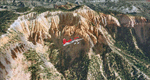
Bryce Canyon National Park (KBCE), Utah, Photo-Scenery (FS9 & FSX)
Despite its name, Bryce Canyon is not actually a canyon that was formed by a river, but rather a giant natural cliff shaped through erosion by wind, water, and ice. Bryce is distinctive due to its geological formations, delicate and colorful pinnacles called hoodoos that are up to 200ft high. The bizarre forms and red, orange and white colors of the rocks provide spectacular views. Unfortunately the hoodoos are too small for the elevation mesh in flight simulator. But you can enjoy the colors and shape of the cliffs. The cliffs in main region of the park, just south of the airport are partly covered
by snow. But on the southern and western part of the plateau you can enjoy them free of snow. Bryce Canyon is named after the Mormon pioneer Ebenezer Bryce who settled in this area in the 1850s. It was designated as a national park in 1928.
Bryce Canyon Airport (KBCE) just handles small aircraft on a daily basis. But is was actually built to handle larger aircraft in case of emergency. And so on Oct.6th 2000 an American Airlines MD-82 from Denver to Los Angeles made a successful emergency landing after reporting smoke in the cockpit and a loss of cabin pressure.
High resolution versions of this scenery for FS9 and FSX (much sharper, but larger and multiple downloads)are available at www.blueskyscenery.com/CNY_South2West4.html . The screenies are taken from the high-res versions, so expect this version to be slightly more blurry. Thanks to Joop Mak for providing a custom AFCADs that correct airport layouts so that they align with the photo-textures! They are available here: www.blueskyscenery.com/AFCADs.html . YourDonation@Work: Dedicated to Michael, Pat and Keith.
| Filename: | Bryce_Canyon_National_Park_KBCE_Utah_PhotoScenery.zip |
| License: | Freeware, limited distribution |
| Added: | 7th March 2010, 11:17:56 |
| Downloads: | 2,206 |
| Author: | Gottfried Razek, blueskyscenery.com |
| Size: | 96.35 MB |
| Category: Flight Simulator 2004 - Scenery | |
| Fort St James CYJM in British Columbia Canada |
|
Images related to this file:
File Description:
Fort St James is a small town of around 1,600 folks at the southeastern end of Stuart Lake, at the head of the Stuart River, and around 360 miles north of Vancouver and 220 miles inland from the coast. It was a long-established trading post for furs, with a permanent presence there from 1806 onwards. The airfield is 3 miles south of the town and is called "Fort St James (Perison)" in the Nav Canada listings. I presume that this is part of their trend towards calling airfields by their location rather than by their name. Makes sense as it is difficult to find information by searching for an airfield that is listed under a name you don't know. The field has an asphalt runway of 4,000 feet aligned 10-28 and at 2,364 feet ASL. There is no lighting. The main user of the airfield is Interior Helicopters Ltd. who are based there as operators, and at Williams Lake as helicopter dealers. For the AI helicopters, there is a screenshot (01) of the AS350 helicopter installation folder when it has been transformed into an AI helicopter. The process is to download and install the Ecuriel AS 350, along with the additional textures, as normal; this is straightforward. Then you download the software shown in screenshot 02 and add it as instructed and as shown in 01 so that the helicopter now operates as AI, with a different air file and a modified config file. I should have included this with the Pemberton post. I have posted this as Fort St James CYJM, but I suggest that you just add it to your previously created "BC airfields" and avoid the inevitable doubling up of common textures etc. Up to you. If you find a defect, email me.
| Filename: | Fort_St_James_CYJM_in_British_Columbia_Canada.zip |
| License: | Freeware, limited distribution |
| Added: | 23rd November 2020, 20:14:04 |
| Downloads: | 151 |
| Author: | Roger Wensley |
| Size: | 2.62 MB |
| Category: Flight Simulator 2004 - Scenery | |
| Brevoort CWOB and BAF-3 radar plus Cartwright LAB-6 radar Canada |
|
Images related to this file:
File Description:
Brevoort airstrip and the BAF-3 radar it serves is on Brevoort Island, off one of the southeastern tips of Baffin Island and 140 miles east of Iqaluit. This scenery includes the BAF-3 buildings on the hilltop and those on the airstrip below, plus the roads connecting them and down to the beach landing area on the rocky coast. This scenery is made for the FSGenesis 76m terrain mesh for northern Canada, and there will be a repost of all my northern Canada airfields to suit this; I cannot think now why I never installed this mesh before. The AI reflects the use of civil airlines for resupply and transportation of personnel. Given the terrain the wind should be from the north so that ai lands using the 02 runway. Landing from the north will involve a terrain clash while take off towards the north will not as the climb out clears the hilltop. The video shows the 600 foot cliff at the runway threshold and an Air Tindi plane on the apron. Cartwright CYCA is on the Labrador coast and has been posted by Flight Ontario as part of their Goose Bay and Labrador Regional Airports sceneries. The nearby LAB-6 radar site is included here, connected to CYCA by an extended road. The site uses the same buildings as Brevoort and Saglek (posted recently) and although I have included them here as separate sceneries the contents can be placed in the same folders as Saglek with a saving in duplicated textures. The textures here are more accurate than Saglek so say yes to over-write; a downloader with personal experience of Brevoort noted that in reality they are lighter.
| Filename: | Brevoort_CWOB_and_BAF3_radar_plus_Cartwright_LAB6_.zip |
| License: | Freeware, limited distribution |
| Added: | 20th August 2017, 15:46:36 |
| Downloads: | 176 |
| Author: | Roger Wensley |
| Size: | 4.37 MB |
| Category: Flight Simulator 2004 - Scenery | |
| Alaska South Slope 12; Teller K54 |
|
Images related to this file:
File Description:
There are four main northwestern Alaska towns which are serviced by Alaska Airlines, and from which local flights spread out. The northernmost is Barrow. Southwest of Barrow is Kotzebue, then Nome, and the furthest south is Bethel (not yet made). This is the fifth in a series for local flights from Nome, and it is on the coast around 55 miles east of Wales and 55 miles northwest of Nome. There are two other airfields around a large lagoon that is almost totally enclosed from the sea, and Teller is on the easten shore, just 15 miles east of Port Clarence and 5 miles southeast of Brevig Mission, both already posted. Teller has a populaton of around 230, down from the 5,000 or so in the early 1900's after the Bluestone Placer Mine struck gold. Tollef Brevik was a Lutheran missionary who was both a pastor and teacher for the Inuit in the area from 1894 onward, travelling from community to community but based in Teller, where the Teller Mission Church was later renamed the Brevig Mission. The name was later appropriated and used for the curent village of that name; he was surely very well regarded by the local population. Unusually, it is possible to drive from Nome to Teller in summer, on a dirt road. Conversely, the road that shows in FS9 to the north towards Brevig Mission (courtesy of Ultimate Terrain) does not in fact exist except in winter, when it is estabished on the snow by the tyre tracks of users. The airstrip is southeast and 2 miles by road from the main part of the village on the spit, with a gravel runway 02-25 which is 3,500 feet of gravel. The AI is the usual for this area, Bering and ERA with some GA and cargo by Everts.
| Filename: | Alaska_South_Slope_12_Teller_K54.zip |
| License: | Freeware, limited distribution |
| Added: | 25th October 2016, 21:21:14 |
| Downloads: | 235 |
| Author: | Roger Wensley |
| Size: | 2.96 MB |
| Category: Flight Simulator X - Sounds | |
| Boeing 737NG CFM56-7B Ultra Effects Edition |
|
File Description:
SkyHigh Audio Simulations is proud to present what is quite possibly the most realistic sounding Boeing 737NG sound pack available! This sound pack is designed specifically for the PMDG 737NGX, and will not work properly in any other 737NG aircraft add-ons in MS FSX, or Prepar3D. Seperate 737NG versions for the freeware TDS, Vistaliners/Kittyhawk, default 737-800, and other 737NG add-ons will follow shortly.
We have gone through great lengths to make this sound as realistic as possible through all stages of flight and through all dimensions of the exterior view, as well as the interior points of view. These sounds will raise the bar for all future jet sounds for Flight Simulator X!
One new and amazing feature in this sound is the interior 3D Sound Cone environment specifically for the PMDG 737NGX version. The sound environment will change inside as you 'scroll' back towards the engines and wings in the 3D interior view (virtual cockpit view).
Perhaps the best part of these sounds is the exterior fly-by! Using 3D Sound Cone technology, there are two exterior buzzsaw sounds, one distant and one up close. Two jet whine sounds, one for front and rear, and one for side-on to the plane. There are three powerful sounding rumble/exhaust sounds, one 'whooshing' sound effect for side one, one powerful blast sound for behind the engine, and one low rumble for when the plane is flying overhead at a distance. All in all, this will create one of the most realistic sounding in-game jet fly-by sound experiences for Flight Simulator X, especially for the CFM56-7B 737NG in FSX.
We hope you enjoy these new ultra-realistic 737NGX sounds for FSX. Actually we know you will enjoy them!
| Filename: | Boeing_737NG_CFM567B_Ultra_Effects_Edition.zip |
| License: | Freeware |
| Added: | 8th December 2014, 12:03:20 |
| Downloads: | 15,493 |
| Author: | Adam Murphy and Jesse Casserly - Skyhigh Audio Simulations |
| Size: | 79.16 MB |
| Category: Flight Simulator X - Scenery | |
| US Navy Collection, with Flyable UAV |
|
Images related to this file:
File Description:

Unfortunately the Navy has cancelled or scaled down most fleet week celebrations around the nation. With this collection, you can stage your own!
Among the latest and hottest additions to the US Navy arsenal is the LCS. Two versions have been developed, the trimaran corvette by General Dynamics and Lockheed Martin's version, which promise to give a double black eye to Al Qaida, Somali pirates, or anyone else that opposes Freedom and Independence. Also are included in this package are the Arleigh-Burke class destroyer USS Fitzgerald, the Ticonderoga class cruiser Lake Champlain and two Oliver-Perry class frigates, FFG-58 Samuel B Roberts and FFG-60 Rodney M Davis. The centerpiece of the fleet is LHD-2 USS Essex and thanks to Arno's fantastic ModelConverterX, Essex is able to feature a highly detailed deck packed with 7 F-35b JSF, 6 MV-22 Osprey, 5 CH-53 and 2 Seahawks. Finally, SSN775 Texas, as part of the collection is available for patrol. All ships have landable decks, night lights and animation effects. Texas as a submarine is more of a boat, I believe, but it has navigation lights and wake effects.
I have also included another hot Navy addition, the RQ-8 fire Scout. There are two versions, a static RQ-8b lashed to the deck of Independence and an RQ-8c with the Flir Brite Star electro/optical turret which I have made flyable, largely for absence of deck space to place it as static.
Make no mistake that the Essex model is very resource intensive, with all it's polygons and what have you. The night lighting is stunning (imo) but seems to have an even heavier effect, you've been warned..
| Filename: | US_Navy_Collection_with_Flyable_UAV.zip |
| License: | Freeware, limited distribution |
| Added: | 19th October 2013, 20:27:36 |
| Downloads: | 1,291 |
| Author: | Rick Keller |
| Size: | 96.89 MB |
| Category: Flight Simulator X - Scenery | |
| LGTS X 2014 - Thessaloniki Makedonia Airport |
|
Images related to this file:
File Description:

Eight years after the first scene the group of Greek airports Project invites you to travel in Thessaloniki which marked the route of the group in the area of Flight Simulator. The scene following the design of our philosophy which allows the simmer to enjoy a full scene without getting tired to find solutions which have to do with settings, yields etc, without unnecessary construction that nobody ever sees and which only need to create a commercial impression in some photos. Objects reconstructed with Gmax and 3dmax that make you enjoy your virtual trip to the airport, and not only because this time we have also included many points from the beautiful city of Thessaloniki as for example the known White Tower, the Aristotelous Square, the facilities of the Thessaloniki International Fair, the football stadiums of the best known groups, the opera house, the City Hall, and many others in a separate scenery (THESSALONIKI_VFR ) included in this version which you are not obliged to install but in our opinion will give you a different sensation in your approach to Macedonia airport. The THESSALONIKI_VFR also combined with the very good photoreal from Antonis Gikas state of GAP "Hellenic Actual Scenery" and with any other photoreal is circulated to the region. This photoreal version is currently for FS9 but very soon will follow and the version for FSX, P3DV1/P3DV2. Retained many of the features of the previous version as the transparent windows which give different feel on the inside part of the terminal, and replaced with different modern way. Of course for the FSX version corrected all non-compliant issues from FS9 - FSX. Enjoy free your flight for the magnificent Thessaloniki, in Greece, in Macedonia.
| Filename: | LGTS_X_2014__Thessaloniki_Makedonia_Airport.zip |
| License: | Freeware |
| Added: | 20th March 2014, 20:12:03 |
| Downloads: | 14,004 |
| Author: | GREEK AIRPORTS PROJECT - Team Chief: Michalis Triantafillou |
| Size: | 91.25 MB |
| Category: Flight Simulator 2004 - Scenery | |
| LGTS 2014 - Thessaloniki Makedonia Airport |
|
Images related to this file:
File Description:

Eight years after the first scene the group of Greek airports Project invites you to travel in Thessaloniki which marked the route of the group in the area of Flight Simulator.
The scene following the design of our philosophy which allows the simmer to enjoy a full scene without getting tired to find solutions which have to do with settings, yields etc, without unnecessary construction that nobody ever sees and which only need to create a commercial impression in some photos.
Objects reconstructed with Gmax and 3dmax that make you enjoy your virtual trip to the airport, and not only because this time we have also included many points from the beautiful city of Thessaloniki as for example the known White Tower, the Aristotelous Square, the facilities of the Thessaloniki International Fair, the football stadiums of the best known groups, the opera house, the City Hall, and many others in a separate scenery (THESSALONIKI_VFR ) included in this version which you are not obliged to install but in our opinion will give you a different sensation in your approach to Macedonia airport.
The THESSALONIKI_VFR also combined with the very good photoreal from Antonis Gikas state of GAP "Hellenic Actual Scenery" and with any other photoreal is circulated to the region.
This photoreal version is currently for FS9 but very soon will follow and the version for FSX, P3DV1/P3DV2.
Retained many of the features of the previous version as the transparent windows which give different feel on the inside part of the terminal, and replaced with different modern way.
Of course for the FSX version corrected all non-compliant issues from FS9 - FSX.
Enjoy free your flight for the magnificent Thessaloniki, in Greece, in Macedonia.
| Filename: | LGTS_2014__Thessaloniki_Makedonia_Airport.zip |
| License: | Freeware |
| Added: | 20th March 2014, 20:10:20 |
| Downloads: | 3,561 |
| Author: | GREEK AIRPORTS PROJECT - Team Chief: Michalis Triantafillou |
| Size: | 91.66 MB |
| Category: Flight Simulator X - Gauges | |
| TCAS and Traffic Display Gauge V2.0 |
|
Images related to this file:
File Description:
This TCAS and Traffic Display Gauge Version 2.0 includes significant improvements from V1.0. It has been developed for the FSX Flight Simulator SP1/2 also. It should also work with Acceleration.The functionality for the TCAS part is based on general specs for commercial aircrafts. It does not provide in detail the function for a specific aircraft model. It is a generic gauge, and can be simple added to any aircraft as a standalone popup window.
In addition the gauge provides a AI traffic display in the ranges of 10,20, and 40 miles.Within this display mode, no TCAS rules are valid, which means all AI aircraft are displayed independent of any altitude or distance.
Improvements in V2.0 are: 1: Full TCAS and traffic display capability is provided even though your aircraft is on the ground. Only the trigger of the alarm/warn sound and the blinking lamp display willbe blocked. 2: An AI HDG pointer will be displayed. It shows in which direction the AI is moving. 3: A bearing pointer has been introduced. It allows the pilot to point to a specific AI.4: The AI additional text info display follows the structure of an ATC text.5:The AI additional text can be selected individually per AI with a mouse click.
6: Each AI display contains a ID index number (0 � 20).7: The design of the TCAS and Traffic Display Box has been updated.8: Increased the number of AIs displayed on the screen in display mode.
For installation and functional description look at the doc inside the ZIp.
CREDIT goes to :
Stefan Schneider for his support on special XML issues and TCAS functionality.
Bob Familton for his review of the documentation and testing for SP1 FSX.
Doug Dawson for his dsd-XML-sound interface in order to generate the sounds.
| Filename: | TCAS_and_Traffic_Display_Gauge_V20.zip |
| License: | Freeware |
| Added: | 25th October 2010, 13:37:36 |
| Downloads: | 3,753 |
| Author: | Dietmar Loleit |
| Size: | 981.32 KB |


© 2001-2026 AVSIM Online
All Rights Reserved
Privacy Policy |