
Where Flight Simulation Enthusiasts Gather from Around the World!
AVSIM Library - Search Results

| Category: Flight Simulator 2004 - Aircraft Repaints, Textures and Modifications | |
| VARIG Boeing 737-341 (PP-VOD) |

|
File Description:
VARIG B.737-341 PP-VOD C/N 24275-1637.
The model B.737-341 is the original series 300 builded by Boeing for VARIG(17 exemplaires builded).VARIG fleet had differents variant of the Boeing 737'(B.737-2C3Adv,B.737-241,B.737-2K9,B.737-2Q8,B.737-219,B.737-33A,B.737-36N,B.737-3K9,B.737-341,B.737-3Q8,B.737-4YO,etc)and the planes are the workhorse of the route systeme of the airline.The main technical center is located a Rio de Janeiro Antonio
Carlos Jobim(Galeao)with the most big hangar maintenance in South America.
I have included a serie of 90 Flights to the main national and international destinations,all served with 737 and the timetable and numbers flights are the rights one of this year 2004.
Destinations are revised and actualised like in the reality(Curitiba,Porto Alegre, Ponte aereo=Rio Santos Dumont-Sao Paulo Congonhas,Recife,Salvador,La Paz,Cordoba,etc.
Many flights are corrected to be acomplished with the 737 and not the Douglas DC-10(out of service by VARIG long time ago and remplaced with the MD-11,this last also to be tasked in the future to fly only cargo).
Today only two DC-10 fly cargo services with VARIG Logistica.
Also included a new complete revised AirFile for the 737-300 type(17-04-04).
| Filename: | VARIG_Boeing_737341_PPVOD.zip |
| License: | Freeware |
| Added: | 17th April 2004, 23:36:08 |
| Downloads: | 383 |
| Author: | Daniel Nole |
| Size: | 456.4 KB |
| Category: Flight Simulator 2004 - Scenery | |
| VAOZ Nashik/Ozar, India |
|
File Description:
Googly scenery for Ozar, a small domestic airport located in Nashik (or
Nasik), 111 miles from Mumbai (Bombay). Nashik is a fast-expanding city in
the Maharashtra state in the Western Ghats located on the western edge of the Deccan
peninsula and is known as the Wine Capital of India or Grape City.
Owing to its close proximity to Mumbai, the airport has not proved popular as
the journey by taxi, bus or rail is not much greater after taking into account
check-in times etc. Air Deccan recently withdrew all flights from Ozar and as
far as I can establish the only airline now serving Ozar is Jagson Airlines,
using Dornier 228 turboprops. There is also a military presence at the east
end of the airport.
Flight Simulator 2004 has only provided a runway at this airport and this scenery
seeks to redress the situation so that you and your "AI" traffic can use the
airport.
The scenery does not purport to be ultra-accurate. Based on high quality
satellite imagery from Google Earth, the layout is proportionally correct but the
added airport features, such as buildings, are built from default Microsoft objects
and add-on libraries so will not look exactly like the real thing.
You are not obliged to download and install any additional scenery libraries,
but to enjoy this scenery in its entirety, you may wish to. It will work fine,
with or without.
| Filename: | VAOZ_NashikOzar_India.zip |
| License: | Freeware |
| Added: | 22nd April 2008, 07:55:32 |
| Downloads: | 737 |
| Author: | John Hinson |
| Size: | 118.11 KB |
| Category: Prepar3D V1-4 - Aircraft Repaints, Textures and Modifications | |
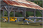
| USAAF 3X-W "That's all, Brother!" Douglas C-47 (292847) |
|
Images related to this file:
File Description:

This folder contains a repaint for version 3.14 of the Douglas C-47 by Manfred Jahn and colleagues in the colors of C-47A 42-92847 3X-W "That's All, Brother!"of the 438th TCG, based in Greenham Common, England. It was the aircraft that was the lead plane with the parachute droppings on the night of D-Day, dropping men of 502nd PIR of the 101st Airborne Division arond 00:48. It then returned to Greenham Common and later that day pulled a glider to Normandy to reinforce the 82nd Airborne Division. Later it evacuated wounded from France, took part in Operation Market Garden, flew supplies to Bastogne, took part in Operation Varsity, before returning to the US in 1945. It passed through the hands of several private owners, is rumoured to have flwon for the CIA, and was restored as an AC-47 gunship by the Aero heritage Museum in 2004.. In 2008 it went to Basler for conversion to a turboprop BT-67, when somebody recognised the significance of this aircraft. A kickstarter campaign secured the purchase by the Commemorative Air Force, who are planning to restore her to her D-Day configuration. More details on this, including D-Day footage, can be seen here: http://ww2live.com/en/content/world-war-2-forgotten-d-day-bird-s-all-brother-will-be-restored-and-itll-fly-thanks. Repaint by Jan Kees Blom for Manfred Jahn's C-47 version 3, based on the paintkit by Gman5250.
| Filename: | USAAF_3XW_Thats_all_Brother_Douglas_C47_292847.zip |
| License: | Freeware |
| Added: | 9th September 2018, 03:44:19 |
| Downloads: | 618 |
| Author: | Jan Kees Blom |
| Size: | 9.85 MB |
| Category: Flight Simulator 2004 - Aircraft Repaints, Textures and Modifications | |
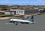
| Tarom ATR-42-500 'YR-ATG' |
|
File Description:
For Traffic 2004. TAROM ATR42-500 YR-ATG(C/N 605)ex F-WWLG. TAROM((Transporturile Aeriene Romane) is the official airline of Romania. His fleet after the restructuration in the early 90´s is today composed with
6 ATR-42-300 and 9 B.737-300 and 700 series(models B.737-38J,B.737-78J and one B.737-36Q).All 707´s and soviet types are now stored and out of service.The two A310 are in reserve and also out of service or saled the fleet of ROMBAC 1-11(BAC 1-11 build under licence by Romaero.The ATR´s are the subtitute for the olds BAC 1-11 and medium soviet types.TAROM ATR42 served national destinations(Cluj,Constanta,Tirgu Mures,Timisoara,Satu Mare,Oradea,Iasi,etc)and some others Internationals like Athens,Thessaloniki and Chisinau.TAROM main hub is located at Bucarest Otopeni Intl airport.The plane is very practical for landings in short and few prepared runways and his consum of only 204 gal/hour play a important factor in the economical explotation of the type by TAROM. I have included a serie of 64 TAROM flights, all served with the B.737-300´s and ATR42-500´s.
Also included a new complete revised AirFile for the ATR42-500 type(23-04-04)with the right engine power, consum,weight parameters,fuel,aerodynamics,etc for a right ATR42-500 model.
| Filename: | Tarom__ATR42500_YRATG.zip |
| License: | Freeware |
| Added: | 25th April 2004, 02:07:35 |
| Downloads: | 425 |
| Author: | Daniel Nole |
| Size: | 287.15 KB |
| Category: Civil Flight Simulators - Micro Flight | |
| Micro Flight 5 |
|
File Description:
Micro Flight is a state of the art flight simulator specializing in simulating ultralight flying vehicles and micro meteorological conditions.
Unlike other flight simulators, Micro Flight simulates the intricate flow of air over the ground and the effects of thermals created by the sun, making it ideal for simulating gliders of all types.
Micro Flight also simulates types of vehicles not simulated by other general aviation programs, such as: Hanggliders, Paragliders, Gyroplanes, Helicopters, Trikes, Balloons and more.
Flight instrumentation and navigational aids were made to resemble real ones, this includes the hand held GPS, standard flight instruments, head up display and more.
The whole enviroment which the user interacts with is three dimentional, even operating the instruments in the cockpit is made by manipulating them with the mouse and not just by pressing keys.
The terrain model used is detailed and optimized, giving the terrain a photorealistic look while still maintaing a high frame rate during run.
The program supports a wide variety of scenery formats, and can import aerial photography and USGS digital elevation data directly.
The program includes flight recording and anaylis, giving the user the ability to study the flight in detail and export it's path in digital form for any purpose.
The program has netplay mode which enables users to fly and communicate with each other.
All this and more make the program a unique and valueable tool for flight simulation.
Copyright Ilan Papini 1999 - 2004 ©
| Filename: | Micro_Flight_5.zip |
| License: | Commercial demo |
| Added: | 16th December 2004, 04:03:44 |
| Downloads: | 543 |
| Author: | Ilan Papini |
| Size: | 6.46 MB |
| Category: Flight Simulator 2004 - Scenery | |
| Avon STOLPort (KWHR) |
|
File Description:
A recreation of the Avon STOLPort (ident KWHR) for MS Flight Simulator 2004, A Century of Flight. Avon was operated as an exclusive destination for Rocky Mountain Airways between (approximately) 1978 and sometime in the late 80's or early 90's. The 4,000' runway was short for the nearly 7,500' elevation, and surrounded by mountains, some towering over 6,000' above the airport elevation. To allow all weather operation, the airport eventually featured what was reported as the steepest ILS ever constructed, with a seven degree glideslope. RMA had exclusive use of the tiny STOLPort and operated it with 50-passenger De Haviland Dash 7 equipement.
Lacking the original chart, I surveyed in FS and plotted what is hopefully an accurate representation of the ILS approach, using my best understanding of TERPS - the US standard for instrument approaches. I also created an NOS-style IAP chart of this approach for the package. A text Takeoff Minimums & Procedure is also included.
AI ATC & traffic recognition of the approach will hopefully follow, but does not exist yet. In other words, you can fly this approach and see the localizer in the GPS, but AI ATC will not give you vectors to it. You'll need to follow the full procedure included on the chart.
Please see the full Readme.txt in "Flight Simulator 9\Addon Scenery\KWHR\Docs" in this zipfile for information on installation of the scenery, flying the approach, and more on the history of the Avon STOLPort.
| Filename: | Avon_STOLPort_KWHR.zip |
| License: | Freeware, limited distribution |
| Added: | 12th May 2008, 23:14:38 |
| Downloads: | 418 |
| Author: | Stephen Comer |
| Size: | 2.1 MB |
| Category: Flight Simulator 2004 - Scenery | |
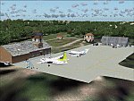
| Tongass Remote Airfield v2 - for Tongass Fjords |
|
Images related to this file:
File Description:
Tongass Remote Airfield v2 - for Tongass Fjords (FS9)
"Tongass Remote Airfield" v2 (RATR) Alaskan bush flying scenery (Fictitious).
This airstrip is for Flight Simulator 2004 and for the "Tongass Fjords" (FS9) addon by Holger Sandmann & Bill Womack; you must have "Tongass Fjords" (FS9) for this to work. Version 2 is a detailed, stand alone, remake of the first version, see PDF file.
Field history and description:
In the early days this area was well known to prospectors and hunters. A small mine was established and later abandoned. Around the late 40s a crew was contracted to clear a small landing area to gain easier access for hunters and campers. Due to the extreme remoteness of this area that clearing took several years. The last phase was the approach, clearing by hand a descending glide slope through just the tops of the tall trees. There is now just enough room for a very experienced pilot to get in and out of this field. The airfield is 26 miles north of Petersburg Alaska (PAPG). This is a tricky narrow approach with a left hand dogleg and then an immediate right hand dogleg turn just before the final approach. Not much time to set up your approach; also, it's a very short runway. For experienced pilots only, and make sure that your life insurance is up to date. Good luck.
| Filename: | Tongass_Remote_Airfield_v2__for_Tongass_Fjords.zip |
| License: | Freeware, limited distribution |
| Added: | 22nd March 2010, 13:16:16 |
| Downloads: | 625 |
| Author: | Jay Langham |
| Size: | 6.18 MB |
| Category: Flight Simulator 2004 - Scenery | |
| EVVA Ventspils International, Latvia |
|
Images related to this file:
File Description:
Googly scenery for Ventspils International - Latvia's third largest commercial airport
(try not to laugh!) although no facilities other than a runway are provided in Flight
Simulator 2004. These scenery files add taxiways, aprons, buildings and other airport
features, so that you and your "AI" traffic can land, taxi, park and take off in a
realistic manner.
The airport serves the city of Ventspils in northwest Latvia and opened as recently
as 1975. Owing to changes in the political situation, operations ceased in 1983 but
it re-opened in 2000. At present, it is unclear which operators serve the airport
- Air Baltic is the claimed contender but there is no evidence in their advertised
schedules. It is believed that occasional flights are operated to St Petersburg and
Moscow by Russian operators but information is hard to come by. Nevertheless, the
airport's own web site (http://www.airport.ventspils.lv/) has figures showing the
increasing numbers of passengers passing through the airport, so something must
call here! The airport also sees a respectable amount of General Aviation activity
and AVGAS has recently been made available.
The scenery does not purport to be ultra-accurate. Based on high-detail satellite
imagery from Google Earth, the layout is proportionally correct but the added
airport features, such as buildings, are built from default Microsoft objects
and add-on libraries so will not look like the real thing. [File re-uploaded at request of AVSIM]
| Filename: | EVVA_Ventspils_International_Latvia.zip |
| License: | Freeware |
| Added: | 15th June 2010, 00:59:50 |
| Downloads: | 1,596 |
| Author: | John Hinson |
| Size: | 89.79 KB |
| Category: Flight Simulator 2004 - Scenery | |
| HCMM - Mogadishu International Airport, Mogadishu/Petrella, Somalia |
|
Images related to this file:
File Description:
Googly scenery for HCMM Mogadishu/Petrella, the capital airport of Somalia.
Astonishingly, in Flight Simulator 2004 this international airport is depicted as little
more than a runway! Whilst in the real world the airport can hardly be
described as busy, it is served by the country's sole airline - Jubba
Airways, with their wonderful Ilyushin IL-18, and many African and Eastern
European operators call by with cargo flights. In fact, the vast proportion of
the aircraft seen here are Russian-built.
These scenery files add aprons, taxiways, buildings and other airport features to Flight Simulator's limited representation and allow "AI" traffic to land, taxi, park and take off in a realistic manner. But do watch out for cars on the runway and taxiways as they
appear to be regularly used as a by-pass to the perils of driving through the city!
The scenery does not purport to be ultra-accurate. Based on high-detail satellite
imagery from Google Earth, the layout is proportionally correct but the added
airport features, such as buildings, are built from default Microsoft objects
and add-on libraries so will not look exactly like the real thing.
You are not obliged to download and install any additional scenery libraries,
but to enjoy this scenery in its entirety, you may wish to. It will work fine,
with or without. [File re-uploaded at request of AVSIM]
| Filename: | HCMM__Mogadishu_International_Airport_MogadishuPet.zip |
| License: | Freeware |
| Added: | 28th May 2010, 20:46:31 |
| Downloads: | 2,790 |
| Author: | John Hinson |
| Size: | 61.51 KB |
| Category: Flight Simulator X - Scenery | |
| ZGGG Guangzhou Baiyun Int'l Airport 2017 |
|
File Description:
Guangzhou Baiyun International Airport (ZGGG) is the major airport of Guangzhou, China. Located in Guangzhou's Baiyun District, it opened on August 5, 2004, but has gone through major changes since FSX was created. The default version only has one terminal and two runways and is slightly out of place from the actual location. I placed the airport in its real location based upon the charted latitude and longitude of the airport reference point. Guangzhou Baiyun Int'l Airport now has three runways. The third runway opened in February 2015. The centerpiece is the new Terminal 2, faithfully rendered here as much as possible. The terminal footprint and gates are accurate. The 3D terminal itself is a simple Sketchup project with generic textures (including night textures). The scenery converted and placed using MCX's amazing Convert and Place Wizard. I added the FBO ramp and the FEDEX Cargo Ramp Aprons and added some hangars to both locations, all default FSX buildings, so no additional library downloads are required. The new runway (now called 02R/20L) was added with Airport Design Editor. The old runway 02R/20L was renamed to the current runway 02L/20R and the old runway 02L/20R was renamed to the current runway 01/19. All taxiways are accurately drawn and designated with taxisigns using the latest AIRAC 1712 Jeppesen chart for ZGGG. All six ILS approaches are rendered as well as ADE would let me.
| Filename: | ZGGG_Guangzhou_Baiyun_Intl_Airport_2017.zip |
| License: | Freeware |
| Added: | 26th November 2017, 22:43:37 |
| Downloads: | 1,083 |
| Author: | Randy Tyndall |
| Size: | 490.4 KB |
© 2001-2026 AVSIM Online
All Rights Reserved
Privacy Policy |