
Where Flight Simulation Enthusiasts Gather from Around the World!
AVSIM Library - Search Results

| Category: Civil Flight Simulators - Looking Glass Flight Unlimited 3 | |
| Moving Ground Objects Viewer / Editor |

|
File Description:
Moving Ground Objects in FU3 are independent of the Megatile name and just defined using the
UTM coordinates. So far it must be possible to go even outside the region rectangle.
The models are moving on the surface but can go in the air or underground also.
All moving objects are defined in movgrobj.dat files placed in the model subfolder of each
scenery package or for the hard coded objects in the /models folder of the region. Using this utility you can
- Load and view the FLED movgrobj.dat as tree view.
- Sort the Objects by Object name, Model name or Index
- Clone the selected Object, then edit to modify the Object Name
- Edit the Parameter on the selected Object as inside FLED
- Move the Object Path to another location
- Generate a simple long distance path or spiral path
- Selecting by check mark the Objects you want save in the movgrobj.dat file
- Save the result back to movgrobj.dat or another file as binary backup
- Export a tab separated list of the entries usable in MS-EXCEL or MS-Access
- Export a single Object in a .mgo file for an Import into another movgrobj.dat file
- Now you can create a collection of single moving ground objects stored in .mgo files
| Filename: | Moving_Ground_Objects_Viewer__Editor.zip |
| License: | Freeware, limited distribution |
| Added: | 27th July 2004, 03:54:18 |
| Downloads: | 148 |
| Author: | Andre Meystre |
| Size: | 233.69 KB |
| Category: Flight Simulator 2004 - Miscellaneous Files | |
| Airline Inventory |
|
File Description:
Not long ago I embarked on a project to streamline my flight simulator's AI setup. I knew I had too many aircraft texture sets that I was not using, too many unnecessary night texture files, installation of defunct airlines, and the like. So, I put together a spreadsheet showing my AI system with all the airlines and additional pieces such as vehicles and ships. This has been a very large and time-consuming project as my AI system has more than 7,000 texture sets, more than 2,200 airline folders, and other assorted AI components. Inside you'll find an Excel spreadsheet with all my airlines (more than 2,200) listed, Birds, Blimp, Corporate Aircraft, Defunct Airlines, Douglas DC-3, Float Planes, Government Aircraft, Helicopters, Medical Aircraft, Military Aircraft, Personal Registration Aircraft, Ships, and Vehicles - all associated with the FS AI system. In addition, I've included the spreadsheet's source text files for those that do not have Microsoft Excel. NOTE: You can download an MS Excel spreadsheet viewer (freeware) from the Microsoft site. Because of copyright restrictions and the size of my AI system, I have not provided links to specific files. However, I think you'll find the data very useful. See the readme file for a list of possible sources and contact information. Frank Bass
| Filename: | Airline_Inventory.zip |
| License: | Freeware |
| Added: | 6th December 2005, 17:45:39 |
| Downloads: | 1,275 |
| Author: | Frank Bass |
| Size: | 229.85 KB |
| Category: X-Plane - Original Aircraft | |
| B29 Superfortress |
|
File Description:
The Boeing B-29 was designed in 1940 as an eventual replacement for the B-17 and B-24. The first one built made its maiden flight on September 21, 1942. In December 1943 it was decided not to use the B-29 in the European Theater, thereby permitting the airplane to be sent to the Pacific area where its great range made it particularly suited for the long over-water flight required to attack the Japanese homeland from bases in China. During the last two months of 1944, B-29s began operating against Japan from the islands of Saipan, Guam and Tinian. With the advent of the conflict in Korea in June 1950, the B-29 was once again thrust into battle. For the next several years it was effectively used for attacking targets in North Korea. The B-29, named Enola Gay is the airplane from which the first atomic bomb was dropped on Hiroshima in August, 1945.
SPECIFICATIONS
Span: 141 ft. 3 in.
Length: 99 ft. 0 in.
Height: 27 ft. 9 in.
Weight: 133,500 lbs. max
. Armament: Eight .50-cal. machine guns in remote controlled turrets plus two .50-cal. machine guns and one 20mm cannon in tail; 20,000 lbs. of bombs
Engines: Four Wright R-3350s of 2,200 hp. ea.
| Filename: | B29_Superfortress.zip |
| License: | Freeware, limited distribution |
| Added: | 13th March 2003, 04:56:30 |
| Downloads: | 2,371 |
| Author: | Robert App |
| Size: | 781.81 KB |
| Category: Flight Simulator 2004 - Scenery | |
| E T Joshua TVSV on Saint Vincent in the eastern Caribbean |
|
Images related to this file:
File Description:
Saint Vincent island is the northernmost of the group of islands known as St Vincent and the Grenadines, just south of St Lucia. St Vincent is around 17 miles long and 10 miles wide and by far the largest in the group, and the islands have a total population of around 120,000. E T Joshua is at the southern end of the island, adjacent to the capital Kingstown. There is a new airport under construction a few miles to the east which will have a longer runway and a larger apron, and when it is ready E T Joshua will probably be closed and redeveloped.
The terminal and the other smaller buildings are all made with photographic textures; the terminal is now quite old and has seen better days. The airport is a hub for small local airlines and also has regular LIAT flights connecting to other islands. The runway is just a shade under 4,700 feet of asphalt, so there are no direct flights from Europe. The new airport to the east is depicted as under construction; obviously I have not flown there and I have not tried to depict the terminal building which is also under construction but a mystery to me.
| Filename: | E_T_Joshua_TVSV_on_Saint_Vincent_in_the_eastern_Caribbean.zip |
| License: | Freeware, limited distribution |
| Added: | 11th June 2013, 16:29:42 |
| Downloads: | 538 |
| Author: | Roger Wensley |
| Size: | 3.13 MB |
| Category: Flight Simulator 2004 - Scenery | |
| PAAT (ATU) - Attu - Alaska, USA |
|
Images related to this file:
File Description:
Attu is AT the western end of the Aleutian chain of islands in Alaska, around 40 miles west of Shemya. There was small village on Attu before the Japanese invasion in mid 1942, but the island is now uninhabited. The Coast Guard Loran navigation station remains in place, though it is no longer in operation and visitors to the island are now either tourists or wildlife experts conducting surveys of numbers of nesting birds, etc. The runway still usable is aligned 02-20 and 5,800 feet long; right hand circuits on 02 to stay away from rising ground to the west. The "terminal" building has lost its sign regarding the Horny Bird, removed in 2010 by one of the last of the station operators, but the building is still there, as are some sheds and shacks that lately were used for the uncomfortable accommodation of bird counters. FS9 has used an incorrect icao identification for Attu but correcting it now would make life complicated so ATU it is and shall remain. I have removed the default FS9 roads that came complete with streetlights and telephone poles and replaced and amended the layout with gravel roads to better resemble real life, though the island shape is at best approximate, as is usual in FS9.
| Filename: | PAAT_ATU__Attu__Alaska_USA.zip |
| License: | Freeware, limited distribution |
| Added: | 2nd March 2015, 20:58:09 |
| Downloads: | 283 |
| Author: | Roger Wensley |
| Size: | 3.27 MB |
| Category: Flight Simulator 2004 - Scenery | |
| Kangiqsualujjuaq CYLU in northern Quebec, Canada |
|
Images related to this file:
File Description:
Kangiqsualujjuaq is in northern Quebec on the east side of Ungava Bay, which is to the east of Hudson Bay and around 150 miles wide and 120 miles deep. Kuujjuaq, the administrative capital of northern Quebec, is 100 miles to the southwest. The town is on the bank of the George River, and has also been known as Fort George River, George River, etc. There was a Hudson Bay trading post at the town's location as early as 1838, though it was closed and reopened more than once and the town did not grow because of the trading post; the Inuit lived on the coast during the summer but moved 30 miles inland in winter for trapping. A cooperative was formed in 1959 to market fish, and this was the creative force that brought about establishment of the town; a school was built in 1963.
The airport is to the north of the town in a valley between the surrounding hills at 215 feet ASL. The gravel runway is just over 3,500 feet long and aligned 16/34; there is no PAPI, but there is fuel available, both 100LL and JetA. There are flights by Air Inuit and a warning of caribou on the runway during October and November.
| Filename: | Kangiqsualujjuaq_CYLU_in_northern_Quebec_Canada.zip |
| License: | Freeware, limited distribution |
| Added: | 1st February 2013, 21:24:55 |
| Downloads: | 279 |
| Author: | Roger Wensley |
| Size: | 2.76 MB |
| Category: Flight Simulator 2004 - Scenery | |
| Green Lake CBG2 in British Columbia Canada |
|
Images related to this file:
File Description:
Green Lake is on the eastern side of the Coast Mountains of British Columbia, around 40 miles north of Cache Creek and 15 miles south of 100 Miles House (a previous posting). The airfield is beside the lake shore and serves the Flying U holiday ranch with a grass runway 2,575 feet long and aligned 18-36. There is no lighting. There is also mooring on the lake for boats and float planes. I have posted it as Green Lake CBG2, but I suggest that you just add it to your previously created "BC airfields", if you followed my previous suggestion. You then avoid the inevitable doubling up of common textures etc. Plus that way you will have just one FS9 library post to do and new airfields will not need yet another posting. Up to you. It just occurred to me that probably only a few of you have a copy of the Nav Canada Airfields handbook, so won't know the airfield altitudes, which is useful to have amid mountains. So, Pemberton is 670 feet Above Sea Level, Cache Creek 2,034 feet ASL, and Green Lake 3,550 feet ASL. The others to follow as posted. If you find a defect, email me.
| Filename: | Green_Lake_CBG2_in_British_Columbia_Canada.zip |
| License: | Freeware, limited distribution |
| Added: | 18th November 2020, 19:44:00 |
| Downloads: | 89 |
| Author: | Roger Wensley |
| Size: | 10.05 MB |
| Category: Prepar3D V1-4 - Aircraft Repaints, Textures and Modifications | |
| Feelthere E175/E195 V3 SP1+ V3 Resized VC Textures |
|
Images related to this file:
File Description:

These are resized shared and shared lighting virtual cockpit textures for Version 3 (with SP1) of the Feelthere E175/E195 for Prepar3D Verion 4.5 and above. After Service Pack 1, released to date only for the Feelthere E175/E195, performance issues were experienced by some owners of the E175/E195 V3. Specifically, when switching views from the virtual cockpit (VC) to an exterior view and then back to the VC, some users experienced long load times and sustained low frame rates, in some cases as low as 5 fps or lower while in the VC view. The problem was experienced more often in the dusk to twilight times or at dawn. The textures related to these symptoms seem to be the shared textures and the shared lighting textures used by the virtual cockpit. This package is a set of those textures, resized to 2048x2048 (2K) from 4096x4096 (4K). Any textures smaller than 2K were not resized. These textures are only resized; no changes were made to any other attributes of characteristics of the DDS format files. NOTE: Feelthere has kindly given me permission to publish these textures and I thank them for that. To use these textures you must own a copy of the Feelthere Embraer E-JETS E175 AND E195 V3.
| Filename: | Feelthere_E175E195_V3_SP1_V3_Resized_VC_Textures.zip |
| License: | Freeware, limited distribution |
| Added: | 3rd June 2020, 21:28:54 |
| Downloads: | 2,024 |
| Author: | Feelthere, Jeffrey S. Bryner |
| Size: | 452.42 MB |
| Category: Flight Simulator 2004 - Original Aircraft | |
| Lockheed L-749 Constellation Base Pack |
|
Images related to this file:
File Description:
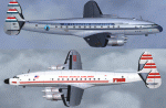
Dimensionally identical to the first-generation Constellation (L-049), the
post-war 749 had more powerful engines, additional fuel tanks, strengthened
landing gear, and much improved performance. Equally good for shuttle hops
and long-range flights, L-749 Connies entered service with major 1950s
carriers such as Eastern, TWA, B.O.A.C., Air France, KLM, Quantas, and many
others. Another customer was the Air Force, which placed an order for ten
aircraft (designated C-121A) in 1948.
Included in this sim package are seven
models and five textures, covering variants with and without "Speedpak"
cargo pannier, weather radar, and "jetstack" exhausts. KLM texture by Jaap
de Baare (representing "Flevoland", the last 749 in flying condition today).
TWA texture N6003C "Star of America" by Hans Herrmann. EAL, Air France, and
MATS textures by Manfred Jahn (including "8609", a frequent visitor to
airshows all over the world until 2005). Panel textures and additional
gauges by Diego S. Barreto, model and VC by Manfred Jahn, panels, gauges,
and animations by Hansjoerg Naegele, flight dynamics by Luis Pallas,
wingview angles, lights, and exhaust effects by Bill Tyne and Roland Berger,
checklist and documentation by Volker Boehme, flight test and handling
research by Stefan Werner. The 749 project has been hosted by Tom Gibson's
Calclassic forum at http://calclassic.proboards55.com.
| Filename: | Lockheed_L749_Constellation_Base_Pack.zip |
| License: | Freeware |
| Added: | 5th December 2009, 04:07:37 |
| Downloads: | 23,677 |
| Author: | Manfred Jahn and 749 Team |
| Size: | 36.17 MB |
| Category: Flight Simulator X - Scenery | |
| KDEN - Denver, Colorado International Airport |
|
Images related to this file:
File Description:
Denver Colorado International Airport For FSX. Several improvements have been made to the default airport, those being:
1. A United Airlines commuter terminal has been added to Concourse B along with custom made jetways complete with the United Airlines logo (these jetways are NOT animated).
2. All jetways and scenery objects will display as long as scenery complexity in FSX is set at normal or higher.
3. The vehicle paths have been redesigned so as not to allow airport vehicles to enter taxiways
4. Optionally, all runways may be opened for AI traffic.
5. The land class has been changed in places so as to prevent autogen objects from displaying on the airport grounds.
6. The tower view has been changed to display from the roof of the control tower.
7. Extra fuel trucks have been added throughout the airport.
8. All gates are accurately portrayed.
9. All taxiways are included and are accurately named, and taxiway signs are accurately placed.
Also, there is an option to place several static United Airlines and Southwest Airlines aircraft in designated spots.
This is an improved version of the airport which I first did in 2007.
Please refer to the README FIRST.txt file for important information
| Filename: | KDEN__Denver_Colorado_International_Airport.zip |
| License: | Freeware, limited distribution |
| Added: | 5th January 2014, 23:51:59 |
| Downloads: | 3,490 |
| Author: | Patrick Finch |
| Size: | 2.57 MB |


© 2001-2026 AVSIM Online
All Rights Reserved
Privacy Policy |