
Where Flight Simulation Enthusiasts Gather from Around the World!
AVSIM Library - Search Results

| Category: Flight Simulator X - AFCAD Files | |
| MHRO - Juan Manuel Galvez International Airport / Roatan, Honduras (version 1.1) |

|
Images related to this file:
File Description:

MHRO - Juan Manuel Galvez International Airport / Roatan, Honduras (version 1.1)
This airport update was made with the latest version of ADE (Airport Design Editor) and made for FSX as a replacement for the stock (default) airport. I found that most stock airports in FSX lack a decent amount of character and realism and this area in particular was dreadful! The stock airport file for Roatan was completely devoid of any life. There were absolutely no parking spots for commercial aircraft and no terminal buildings; the nearby areas of Colonia/Loma Linda were completely barren. I've done major reworking to this airport and added the small terminal building as well as renumbered the runway to the correct designation and length. The nearby town has been rendered complete with a variety of vessels small and large in the ocean. I hope you enjoy. Below is a list of changes/additions. All these enchancements are as close to the real airport as I can get with stock library objects. I've used satellite images, terminal photos and maps throughout the whole process so building locations are as accurate as possible. Happy landings in Honduras!
Features:
*Expanded parking apron
*Terminal building with parking for commercial traffic (Delta and United fly to Roatan from the US with regular service)
*Renumbered runways to correct designations and modified runway length and lighting accurately
*Nearby neighborhoods modeled complete with marinas and cruise ship port (cruise ship parked at the pier visible on approach)
*Diving, fishing, cargo and recreational vessels visible in the ocean surrounding the airport v1.1
*Several hotels dotting the area near the airport as well as West End/Gibson Bight
*Roads with static vehicles near the airport
*Corrected taxiway signs v1.1
| Filename: | MHRO__Juan_Manuel_Galvez_International_Airport__Ro.zip |
| License: | Freeware |
| Added: | 15th July 2012, 06:47:04 |
| Downloads: | 686 |
| Author: | Jaison Diaz |
| Size: | 6.85 KB |
| Category: Flight Simulator X - Utilities | |
| 737 800 NGX fuel planner 1.2 |
|
Images related to this file:
File Description:

CREATION
This fuel planner was made from datas collected by kACARS_free during flights test, and from the PMDG's tutorial, the result is approximate but corresponds relatively well to the consumption of the NGX.
OPERATION
You only have to fill the departure's ICAO - the distance until the arrival - the arrival's ICAO - the distance to the alternate airport - the ICAO of alternate.
You can change :
- APU time,
- taxi departure time,
- taxi arrival time,
- CDB fuel,
- holding fuel
You can also fill the adjustement's datas to the wind :
- average route,
- wind direction,
- wind speed.
If you have headwind, the fuel planner takes it into consideration, but not the tailwind, because the wind can be lower than expected!
If you have any question, ask me:
[email protected]
Changelog :
V1.1
- add fuel planner in kgs
v1.2
- add wind adjustment
- adjust enroute consumption
| Filename: | 737_800_NGX_fuel_planner_12.zip |
| License: | Freeware |
| Added: | 17th March 2013, 10:10:42 |
| Downloads: | 8,886 |
| Author: | Frederic FURST |
| Size: | 107.27 KB |
| Category: Flight Simulator 2004 - Utilities | |
| ILS and GPS Approach Creator v1.1 for FS9 and FSX (for non-US/UK users) |
|
File Description:
The original version of this program did not work on computers in countries which use a comma as the decimal separator (apologies for that). Version 1.1 fixes this problem and should work in all countries (including the US and UK) regardless of the format of their decimal numbers. This is the full package, so you do not need to download version 1.0 as well. If the original version is working on your computer, then there is no need for you to download this version instead, as the two versions are functionally identical. This easy-to-use program allows the user to add an ILS and/or a GPS approach to any airport in FS9 or FSX. The user will be able to select the approach in the GPS unit, and request the approach from ATC. The ATC will then vector you to make an ILS or GPS approach. The AI will also be able to use the ILS approach, and you will hear them say so over the radio. The program was designed with the non-expert user in mind, and no familiarity with XML coding is assumed. The program supports up to four FS installations. The program needs to be run in conjunction with AFCAD (or a similar utility for FSX). You will also need the .NET Framework 2.0 and MSXML 4.0 installed on your computer. Tested with XP Home and Pro. Full instructions included.
| Filename: | ILS_and_GPS_Approach_Creator_v11_for_FS9_and_FSX_f.zip |
| License: | Freeware, limited distribution |
| Added: | 23rd December 2007, 15:18:15 |
| Downloads: | 4,045 |
| Author: | Martin Gleeson |
| Size: | 361.81 KB |
| Category: Flight Simulator 2004 - Original Aircraft | |
| Seagul G-2 (Galeb) |
|
File Description:
FS2002/FS2004 Soko Galeb-2 v1.1 package. The Soko G2-A Galeb (seagull) is a Yugoslav made two-seat advanced trainer powered by the Rolls Royce Viper Mk22-6 engine.

Includes installer for both FS2002 and FS2004. Features full animated moving parts - all control surfaces, canopy, gears, "live" pilots, ejection seats, crash effects, custom sounds, cockpit sound effects, high detail dynamic 3D virtual cockpit with clickable gauges and separate flight dynamics files for FS2002 and FS2004.

Package includes different visual models with nine real life paint schemes for Croatian, Serbian, Libyan and Yugoslav Air Forces, and civilian 'Acro' and 'USAF' markings. Texture templates included. Flight dynamics, panel and XML gauges by Goran Savic, FSDS2 model by Luka Midic.
| Filename: | Seagul_G2_Galeb.zip |
| License: | Freeware |
| Added: | 6th August 2004, 02:47:25 |
| Downloads: | 20,520 |
| Author: | Luka Midic, Goran Savic, Zoran Sivcev, Milan Jeftic |
| Size: | 12.38 MB |
| Category: Prepar3D V1-4 - Utilities | |
| AIGround SimConnect Utility for P3D v4 |
|
Images related to this file:
File Description:
AIGround is a simconnect utility designed to improve AI taxi characteristics at the airport the user’s aircraft is located at. AIGround holds the AI stationary on the tarmac after pushback for a more realistic amount of time before the AI begins its taxi out and optionally performs an extended pushback including more realistically turning the AI toward the apron. The AI will also perform control surface checks as the AI begin their taxi out. Finally, AIGround enforces better spacing between AI and the user’s aircraft when the user is performing a taxi-out or taxi-in. AIGround does this by commanding the AI to temporarily stop in situations that the normal P3D AI control program would miss. In situations where the user might want the AI to pass (e.g., giving way at an intersection), the user can flash the landing lights on the user’s aircraft (on, then quickly off) as a signal to the AI to continue the taxi. AIGround also allows the user to adjust AI landing and takeoff lengths. AIGround is designed to compliment the default P3D AI program and thus is fully compatible with any AI-related program that is compatible with the default AI program (e.g., AIG, Ultimate Traffic Live, Radar Contact, etc.). AIGround is also compatible with the AIFlow simconnect utility. AIGround is targeted to SimConnect Version 4.5.0.0 or later. AIGround operates externally via simconnect and thus makes no changes to the P3D sim. NEW for v1.1: (1) adjust AI landing and takeoff length, (2) option for AI to perform extended pushback including turns, (3) option to disable control checks (for compatibility with certain AI sets), (4) AI plane spotting mode only, (5) adjustable in-sim message level, (6) Periodic read of .ini file to tweak parameters more easily, (7) AIGround starts minimized. FIXES for v1.1: (1) output consolse sometimes froze, (2) AI cyclic stop-start, (3) .ini file would sometimes get confused reading parameter values having whites spaces.
| Filename: | AIGround_SimConnect_Utility_for_P3D_v4.zip |
| License: | Freeware |
| Added: | 3rd July 2020, 23:58:42 |
| Downloads: | 1,841 |
| Author: | Roland Foster |
| Size: | 796.88 KB |
| Category: Flight Simulator 2004 - Scenery | |
| CYEG Edmonton International |
|
File Description:
Re-upload. Based on aerial and ground photos. The main terminal and cargo area buildings were all replaced. The aprons were modified to be more accurate and the smaller cargo area taxiway was added. All the usual goodies are included. V2 is a complete replacement for V1. Due to a nasty bug in EZ-Scenery (since eradicated), the entire V1 scenery was misaligned. That has been fixed. Incorrectly sized objects on the cargo ramps have been fixed. The commuter airline parking at the north side of the main terminal has been corrected to make it more like the real thing. V1.1, which contained just the ramp lighting, has been incorporated into V2.
One significant change is that there are now two versions of the scenery, V2 and V2a. V2, like V1, has static aircraft parked at the cargo ramps. In V2a the static aircraft have been removed so ai cargo planes can park at the cargo ramps. V2a of the AFCAD file has cargo parking spaces added.
| Filename: | CYEG_Edmonton_International.zip |
| License: | Freeware |
| Added: | 21st June 2010, 11:09:00 |
| Downloads: | 12,721 |
| Author: | Sidney Schwartz |
| Size: | 2.49 MB |
| Category: Flight Simulator X - Scenery | |
| NZOP- Opotiki Aerodrome (VectorLandClass, New Zealand) |
|
Images related to this file:
File Description:
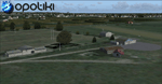
Opotiki aerodrome (ICAO: NZOP) is a small airstrip outside the township of of Opotiki, the gateway to the beautiful East coast of the North Island of New Zealand. Opotiki itself sits at the confluence of the Waioeka and Otara rivers and is surrounded by dairy farmland and Kiwifruit orchards with large areas of native bush to the south and east.
This scenery accompanies Tim Barnes'�� series of other small Bay of Plenty aerodromes (Whakatane,
Galatea, Waihi Beach) for use with VectorLandClass- It features custom modelled and textured buildings, large coverage of beautiful 0.5m aerial photography (fully auto-genned and including seasonal and night variations) and extensive use of high quality objects from the free VLC library. Installation of the library V1.1+ is required for this scenery to work properly and can be downloaded from the VectorLandClass website (www.vectorlandclass.co.nz)
This release, although not requiring it, works best with VectorLandClass topographic mesh and landclass addon covering all 268676 square kilometers of New Zealand. If you'��re not a VLC customer, you'��ll notice when the photoreal coverage runs out!
| Filename: | NZOP_Opotiki_Aerodrome_VectorLandClass_New_Zealand.zip |
| License: | Freeware, limited distribution |
| Added: | 21st February 2013, 13:52:47 |
| Downloads: | 969 |
| Author: | Tim Barnes |
| Size: | 146.68 MB |
| Category: Flight Simulator X - AFCAD Files | |
| CYKA - Kamloops Airport / Kamloops, British Columbia, Canada (v1.2) |
|
Images related to this file:
File Description:
This airport update was made with the latest version of ADE (Airport Design Editor) and made for FSX as a replacement for the stock (default) airport. I've made several changes to the airport which are listed below. All these enchancements are as close to the real airport as I can get with stock library objects. I've used satellite images, terminal photos and maps throughout the whole process so building locations are as accurate as possible. Happy landings in beautiful Canada!
Features:
*Expanded parking apron
*Main terminal building with parking for commercial traffic (renumbered correctly v1.2)
*Seperate parking aprons for GA traffic
*Helipad
*Hangar and other airport buildings added
*Airport vehicles and objects throughout the airport
*Parking lots with static vehicles
*Airport fire station with fire truck
*Static de-icing vehicles & runway plow
*Static aircraft/helicopters
*Corrected communication frequencies (v1.1)
*Recent runway expansion to 8,000ft (v1.2)
*New taxiway Foxtrot,Golf (v1.2)
*New ILS for runway 08 (v1.2)
*Corrected tower elevation bug (v1.2)
(For more information on Endeavourai please visit our site at endeavourai.com or our forums at http://endeavourai.boards.net/)
| Filename: | CYKA__Kamloops_Airport__Kamloops_British_Columbia_.zip |
| License: | Freeware |
| Added: | 9th August 2012, 17:15:56 |
| Downloads: | 736 |
| Author: | Jaison Diaz / Endeavour ai |
| Size: | 127.44 KB |
| Category: Flight Simulator X - Scenery | |
| TTCPx Patch Ver. 1.2 ( Rev. 8 ) |
|
Images related to this file:
File Description:
Unofficial LatinVFR Tobago TTCP for FSX Expansion Pack. This freeware patch contents: New photoreal scenery with seasons to airport area ( day and night for winter/fall and summer/spring seasons ); New ADE with correction of the NDB TAB 323 and park positions, activation of the RWY's 11 and 29, and other minor fixes; Addition of fuel-repair trigger points to the airport ( JetA to Gates 1-4 area, JetA1 to Gates 5-6 area, and AV100 to Gate 7 area ); New land and water classiffication in the entire island of Tobago; Correction of the entire island terrain including a better flatten around the airport area; More buildings, objects, vegetation and life around on the island of Tobago ( FSX default fictitious objects ); More road traffic over the photoreal area; Full set of the TTCP airport charts ( Use for Virtual Flight Only ); Other fixes. It's not a cumulative patch, so remove any previous version to install. System Requirements: LatinVFR Tobago TTCP v1.1 for FSX and Microsoft Flight Simulator X SP2 or Acceleration.
| Filename: | TTCPx_Patch_Ver_12__Rev_8_.zip |
| License: | Freeware |
| Added: | 22nd August 2010, 08:59:46 |
| Downloads: | 2,429 |
| Author: | Gladson Moreira |
| Size: | 32.76 MB |
© 2001-2026 AVSIM Online
All Rights Reserved
Privacy Policy |