
Where Flight Simulation Enthusiasts Gather from Around the World!
AVSIM Library - Search Results

| Category: Flight Simulator X - Aircraft Repaints, Textures and Modifications | |
| Upgraded VC Textures for Default Boeing 747-400 |

|
Images related to this file:
File Description:
I wanted to change the default VC a bit that it looks more like a cockpit of the 747-8i.
This VC also works with the "747-8i SkySpirit 2011 - Project Opensky"
| Filename: | Upgraded_VC_Textures_for_Default_Boeing_747400.zip |
| License: | Freeware |
| Added: | 20th January 2012, 00:51:57 |
| Downloads: | 898 |
| Author: | Jim Fly |
| Size: | 1.76 MB |
| Category: Flight Simulator 2004 - Scenery | |
| Port Armstrong, for Holger Sandmann's Tongass Fjords scenery |
|
Images related to this file:
File Description:
This is a fish farm, at the southern end of Baranof Island and Chatham Strait in southern Alaska. It is named on the chart of the area, and there is a section of the chart included here. This scenery is designed specifically for use in the Tongass Fjord scenery. The fish farm (or hatchery, the description varies) has an identifying code so it will show up on a gps as PAG. There is no interaction with atc as there are no designated water runways, so PAG on the gps just acts as a waypoint. I may have incorrectly identified Tongass Fjords as being required for Hawk Logging when Glacier Bay is needed. Ah well, it is one or the other of them. I still find these scenery areas by Holger and his crew the most satisfying in FS9.
| Filename: | Port_Armstrong_for_Holger_Sandmanns_Tongass_Fjords.zip |
| License: | Freeware, limited distribution |
| Added: | 18th November 2014, 15:14:57 |
| Downloads: | 223 |
| Author: | Roger Wensley |
| Size: | 3.89 MB |
| Category: Flight Simulator 2004 - Gauges | |
| Project Fokker Replacement for UPPER Night Panel Gauge |
|
File Description:
This is the second (and I hope last!) replacement gauge you need for the cockpit of the Project Fokker V2 to work properly (on some machines at least). If you have problems with the cockpit at night (gauges not on their place), you need that file and pf_night.zip for the main cockpit view.
Unfortunately the upper panel is not enlighted, but that would mean a little more work ...
| Filename: | Project_Fokker_Replacement_for_UPPER_Night_Panel_Gauge.zip |
| License: | Freeware |
| Added: | 2nd March 2005, 03:46:26 |
| Downloads: | 9,519 |
| Author: | Georg Aubele |
| Size: | 275.3 KB |
| Category: Flight Simulator X - Gauges | |
| V-One Gauge for Boeing 707-300 Complete |
|
Images related to this file:
File Description:
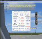
This gauge is specifically written for Captain Sim B707-300 and variants.
List of features: [New Items/Features]
Twenty-Two call-outs sounds integrated into gauge [15 new call-outs].
Take-off V-Speeds calculated for Flaps 14 with temperature and altitude adjustments.
[Take-off speed bugs automatically set for: V1, VR, V2].
[Flaps-up maneuvering speed (clean speed) bug set after flaps-up].
Optimum altitude and optimum EPR (EPR calc for M.80) are continually calculated.
Gross Weight overage will display in 'red' text. Tooltip indicates overweight value (LB/KG).
Take-off trim calculated for current gross weight.
Display units can be toggled between LB and KG (default LB).
Outside Air Temperature can be toggle between Fahrenheit and Celsius.
Resettable fuel use.
Resettable flight timer.
[Selectable Vref landing configurations, Vref40 (default) or Vref50].
[Approach / landing speed bugs automatically set for: Vref, Vref + 5, Vref + 10].
ZFW, Fuel, CG, Gross Weight and Barometric Pressure MSL (QNH) displayed.
['Barometer Set' call-out occurs when pressing keyboard letter 'B' (V-One gauge must be open)].
[Decision Height adjustment now on Data Card in hidden click-spot located on upper right corner].
[Now installation to a single location will work for all variants].
| Filename: | VOne_Gauge_for_Boeing_707300_Complete.zip |
| License: | Freeware, limited distribution |
| Added: | 3rd February 2013, 00:11:24 |
| Downloads: | 2,451 |
| Author: | Paul Tally |
| Size: | 3.14 MB |
| Category: Flight Simulator 2004 - Aircraft Repaints, Textures and Modifications | |
| More realistic landing lights for Boeing 737 NG |
|
Images related to this file:
File Description:

More realistic landing lights texture for all iFly B737 NG.
This package will replace your original landing lights for a more realistic texture. All versions of NG's landing light texture will be overwrite including BBJs.
| Filename: | More_realistic_landing_lights_for_Boeing_737_NG.zip |
| License: | Freeware |
| Added: | 18th December 2011, 17:51:47 |
| Downloads: | 1,547 |
| Author: | Tibor Kokai |
| Size: | 1 MB |
| Category: Flight Simulator 2004 - Sounds | |
| GE90 soundset for the Boeing 777-200LR/300ER |
|
File Description:
This is a modification of Devyn Silverstein’s excellent GE90 soundset, for use with the PSS 777-200LR/300ER (not tested with the Meljet or POSKY 777, but they should work as well). I’ve incorporated into it many flight deck sounds featuring, amongst others, air-conditioning packs, engine startup, landing gear deployment, etc, which were kindly provided by a Captain on the Boeing 777-300ER.
| Filename: | GE90_soundset_for_the_Boeing_777200LR300ER.zip |
| License: | Freeware |
| Added: | 24th November 2008, 16:34:29 |
| Downloads: | 11,382 |
| Author: | Devyn Silverstein, Jimmy Foong |
| Size: | 29.19 MB |
| Category: Prepar3D V1-4 - Miscellaneous Files | |
| Douglas DC-6 Checklist for use with AFE |
|
File Description:
Developed from Klaus Schmitzer's original "Simple DC-6 Checklist" and modified to be used with or without the AFE in the PMDG Douglas DC-6. Was developed from the P3D version but I suspect it would be the same for the FSX version and possible the XP version.
| Filename: | Douglas_DC6_Checklist_for_use_with_AFE.zip |
| License: | Freeware |
| Added: | 14th September 2017, 05:09:18 |
| Downloads: | 476 |
| Author: | Garry Lundberg |
| Size: | 163.04 KB |
| Category: Flight Simulator 2004 - AI Aircraft | |
| Base Pack For McDonnell Douglas/Boeing MD-11 |
|
Images related to this file:
File Description:

FS2004 McDonnell Douglas/Boeing MD-11 base pack for FS2004 AI traffic. (Note:This model pack unlikely works perfectly in FSX and P3D). Model, FDE and repaint by Mitsushi Yutaka (FSpainter).
| Filename: | Base_Pack_For_McDonnell_DouglasBoeing_MD11.zip |
| License: | Freeware, limited distribution |
| Added: | 7th February 2016, 16:06:39 |
| Downloads: | 3,325 |
| Author: | Mitsushi Yutaka (FSpainter) |
| Size: | 9.63 MB |
| Category: Flight Simulator 2004 - Scenery | |
| Retro Scenery for NAS Chase Field, Texas, U.S.A. |
|
Images related to this file:
File Description:

Originally opened as Beeville Municipal Airport, the land was leased from the Navy in 1943 for the construction of Chase Field, a training base for Naval Air Cadets and was one of three satellite airfields for Corpus Christi NAS. At the end of WWII the station was closed and re-purposed for various educational and local civic uses only to be reopened with the commencement of the Korean War in 1953. This resulted in a significant expansion of the original facilities and by the early 1980s Chase Field had a complement of 2,500, along with over 160 aircraft. Finally BRAC-ed in 1991 the field was finally closed in 1993. Scenery contains custom objects as well as photo-realistic ground cover with provisions for appropriate aircraft.
| Filename: | Retro_Scenery_for_NAS_Chase_Field_Texas_USA.zip |
| License: | Freeware, limited distribution |
| Added: | 27th April 2014, 21:31:40 |
| Downloads: | 673 |
| Author: | John Stinstrom |
| Size: | 2.58 MB |
| Category: Flight Simulator X - Scenery | |
| Detailed Terrain Features for Southern Africa, Update 2 |
|
Images related to this file:
File Description:

Scenery consist of Updated Terrain Vector data concerning coastlines, rivers, dams, streams, roads, traffic, railroads, power lines and extrusion bridges for Southern Africa countries South of the Equator. The Scenery was updated by utilizing Satellite image backgrounds. This scenery is important and will be needed with release of future scenery by Aeroworx. Please install fsxWorx01.zip and update (fsxworx01upd1.zip) before this file.
| Filename: | Detailed_Terrain_Features_for_Southern_Africa_Upda.zip |
| License: | Freeware |
| Added: | 11th November 2012, 17:55:20 |
| Downloads: | 4,252 |
| Author: | Hannes Steyn, Aeroworx |
| Size: | 10.72 MB |


© 2001-2026 AVSIM Online
All Rights Reserved
Privacy Policy |