
Where Flight Simulation Enthusiasts Gather from Around the World!
AVSIM Library - Search Results

| Category: Flight Simulator X - Miscellaneous Files | |
| AITT2 for FSX rel 1.5.5 full setup |

|
Images related to this file:
File Description:
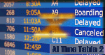
AI TimeTable is a software simulation of an airport time table for MS-FSX, where the airport location is just where your aircraft is positioned. With the rel.1.5.5, it is completed with a TTS for speaking flights announcements, optionally.
It is able to display also user flight (and its "monitor" state) and give a good rate in displaying the correct flights numbers wheras FSX is not able to do.Requires MS-FSX SP1 and Simconnect.dll
| Filename: | AITT2_for_FSX_rel_155_full_setup.zip |
| License: | Shareware, limited functionality |
| Added: | 22nd July 2010, 18:24:02 |
| Downloads: | 698 |
| Author: | V.Mercolino - geniX Software |
| Size: | 11.9 MB |
| Category: Flight Simulator 2004 - Aircraft Repaints, Textures and Modifications | |
| P-51D B6-S 'the Gizzard' |
|
File Description:
This is a repaint only for the WOP P-51D and WWII Fighters P-51D. This aircraft, marked B6-S the Gizzard, of the 363FS, 379FG, was flown by Lt. Guy D. Bender. After the war, it was put on display on Schiphol Airport in the Netherlands, minus the bar over the S, and with added killmarks. It was later scrapped at Schiphol. Repaint by Jan Kees Blom, based on blanks by Shockwave.
| Filename: | P51D_B6S_the_Gizzard.zip |
| License: | Freeware |
| Added: | 16th July 2007, 20:49:23 |
| Downloads: | 195 |
| Author: | Jan Kees Blom |
| Size: | 5.54 MB |
| Category: Flight Simulator X - Aircraft Repaints, Textures and Modifications | |
| Douglas C-47 (NC91008) Alaska Airlines |
|
Images related to this file:
File Description:
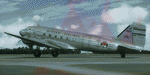
This folder contains a repaint for version 3.14 of the Douglas C-47 by Manfred Jahn and colleagues in the colors of NC91008, a DC-3 that flew with Alaska Airlines between 1948 and its crash in Alaska in 1954. The Museum of Flight in Seattle has DC-3 N138D on display, but painted as NC91008. Repaint by Jan Kees Blom for Manfred Jahn's C-47 version 3.14, based on the paintkit by Gman5250.
| Filename: | Douglas_C47_NC91008_Alaska_Airlines.zip |
| License: | Freeware |
| Added: | 15th August 2018, 11:27:52 |
| Downloads: | 476 |
| Author: | Jan Kees Blom |
| Size: | 11.06 MB |
| Category: Flight Simulator X - Scenery | |
| FS X modified terrain.cfg |
|
File Description:
Everyone should install this file. Flight Simulator X terrain is defined in the terrain.cfg file. During testing, we have determined a certain number of modifications to this file that will correct some problems with the FS world and also provide more options for scenery designers. For example, in some places, water bodies display rocky areas - this file fixes that. Please read the detailed explanation that is included, and then install this modified file.
| Filename: | FS_X_modified_terraincfg.zip |
| License: | Freeware |
| Added: | 7th November 2006, 00:46:33 |
| Downloads: | 70,510 |
| Author: | Microsoft, Richard Ludowise, Luis Féliz-Tirado |
| Size: | 317.55 KB |
| Category: Flight Simulator X - Gauges | |
| AP - Alt - VS MultiFuel Flaps v1 |
|
Images related to this file:
File Description:
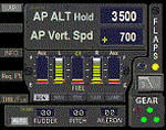
This gauge is for use in the Saitek FIP and is an extension to my recent Baron 58 (FSX default) gauge . That gauge was designed for a specific aircraft whilst this package of three gauges has the same functionality of the BB58 gauge but will work on all aircraft. Each of the three gauges displays fuel level for different tanks but are identical in all other respects. As part of your pre-flight checklist you will need to make sure the right gauge for the aircraft is being displayed.
The set of 3 gauges have been designed to complement the saitek AP / Multi panel. The gauges primarily show the selected AP Altitude and Vert Spd whilst the AP / multi panel is displaying HDG. Five indicators for "lights on" are included as well as lights for landing gear (in transition and down) . The flaps indicator shows a blue light for intermediate positions and a yellow light when at full down position. A separate flaps position indicator (numerical and needle) is included. The 5 fuel indicators in each gauge are vertical analogue 'meters'. Rudder and aileron trim is displayed and controlled by the two FIP rotary knobs. Pitch trim readout and other functions is included.
NOTE. This package includes a pitch trim image file that was inadvertently left out of my original BB58_AP_Alt_VS_and_Fuel_v1.zip folder.
| Filename: | AP__Alt__VS_MultiFuel_Flaps_v1.zip |
| License: | Freeware |
| Added: | 12th July 2014, 07:40:09 |
| Downloads: | 398 |
| Author: | Robert Budd |
| Size: | 183.72 KB |
| Category: Flight Simulator 2004 - Scenery Design | |
| FSDEM 1.1 |
|
File Description:
FSDEM is a graphical tool designed to help on the editing and correction of NASA SRTM (Shuttle Radar Topography Mission) terrain elevation meshes, and to create terrain mesh scenery to be used in Microsoft Flight Simulator 2002/2004.
Program main features:
This version fixes some bugs and adds minor improvements. See the included file history.htm for details.
| Filename: | FSDEM_11.zip |
| License: | Freeware, limited distribution |
| Added: | 4th August 2004, 20:51:02 |
| Downloads: | 5,125 |
| Author: | Emerson de Oliveira |
| Size: | 377.03 KB |
| Category: Flight Simulator 2004 - Scenery | |
| Airports Northern Coast Alaska (PALU, PPIZ, PAWI, AK03) |
|
Images related to this file:
File Description:
The town of Barrow is in the far north of Alaska, and these are coastal villages or radar installations to the west of Barrow, and there will be additions. Cape Lisburne is a gravel runway right next to the coast with radar gear and accomodation buildings close by, and what was called "Top Camp" at the end of a long and steep road to the top of a nearby hill, or mountain. The runway is lit, as are most of them in this area of long dark winter nights. Barrow is 270 miles to the northeast. Point Lay PPIZ used to have a radar installation as well as a village, but the old buildings have now been removed and the gravel runway 05-23 has been lengthened to 5,000 feet to serve the village throughout the year. The population is around 270, living mostly traditionally and with an annual beluga whale hunt. Barrow is 180 miles to the northeast.
Wainwright PAWI, some 80 miles southwest of Barrow and on the coast, has a population of around 570. The PAWI runway is just under 5,000 feet long and like PPIZ is aligned 05-23, lit, and with PAPI on each end. The original runway of some 2,000 feet is still visible next to the apron. Three miles to the southeast there is a third runway, at AK03, serving the Wainwright DEW station. It was decided in 2007 to close the station and to remove the buildings both there and at Point Lay because of subsidence, but everything at Wainwright was still in place in 2009 and beyond. The villages have been "sketched" as opposed to replicated exactly. The texture folder includes the missing car textures for Barrow PABR, and the AI is modified PABR to include passenger flights by Ravn and cargo flights by Northern Air Cargo, plus limited GA. There are no flattened grassed areas at these airfields; they are runways and taxiways and aprons on a bed of gravel on permafrost.
| Filename: | Airports_Northern_Coast_Alaska_PALU_PPIZ_PAWI_AK03.zip |
| License: | Freeware, limited distribution |
| Added: | 16th June 2016, 15:59:24 |
| Downloads: | 357 |
| Author: | Roger Wensley |
| Size: | 10.84 MB |
| Category: Flight Simulator 2004 - Aircraft Repaints, Textures and Modifications | |
| LinksAir McDonnell-Douglas MD-82 |
|
Images related to this file:
File Description:

Released as an open championship gift to flight-simmers who golf (whether on a real course, or in Links 2003), this file contains textures for the Jet City Aircraft payware, which you must have, to make them function. There are FS2002 and FS2004 versions of this payware, and the FS2004 version is known to work in FSX, with a proper FSX panel. The fictive tail number has been placed unobtrusively, and shows a sense of humor. LinksAir is another concept of mine fusing FS with a popular PC golf sim that is still going strong, 9 years after it first appeared. Plans call for operating a virtual European mini-tour, this September (details in the READ ME).
| Filename: | LinksAir_McDonnellDouglas_MD82.zip |
| License: | Freeware |
| Added: | 12th July 2011, 21:18:13 |
| Downloads: | 60 |
| Author: | Henry Douglas/Jet city Aircraft |
| Size: | 2.9 MB |
| Category: Civil Flight Simulators - Looking Glass Flight Unlimited 3 | |
| Airport Editor / Viewer for FU3 |
|
File Description:
Actually there is not a lot to edit, more to view but the edit function can move the full airport
with all nodes and lines and lights at once to a new location referenced by the blue square UTM coordinates and height. Move of just a little bit is possible also.
The Duxford package has been moved from UKS region to SanFran region in 1 minutes :-)
Analyze a single airport or the full game region with all airports in the regions/airports the /packages and the /outterr folder generating a global list of values like runway, parking spots, frequencies, sound names and more. You can lock at an selected airport with the tree view.
| Filename: | Airport_Editor__Viewer_for_FU3.zip |
| License: | Freeware, limited distribution |
| Added: | 25th November 2004, 14:29:20 |
| Downloads: | 381 |
| Author: | André Meystre |
| Size: | 432 KB |
| Category: Flight Simulator 2004 - Miscellaneous Files | |
| Active ILS - KATL v1.0 (Hartsfield Jackson Atlanta International Airport) |
|
File Description:
As most know initiating the ILS at certain airports for AI Traffic is not a function at this time when using AFCAD2. If you add a new ILS runway to an airport such as KATL (10/28) only the user aircraft can use this runway when visibility falls below 3 miles. ATC will no longer use this runway for AI Traffic because FS9 sees it as a visual runway. This will cause ATC to vector your AI Traffic back to 9R/27L which is also a South Cargo/Ramp Departure Runway. There are many additional Scenery Buildings, 274 Jetways and new Terminals (as per current Contractor plans) added to version 1.0. See the readme.txt file for additional details.
| Filename: | Active_ILS__KATL_v10_Hartsfield_Jackson_Atlanta_In.zip |
| License: | Freeware, limited distribution |
| Added: | 11th September 2005, 00:04:37 |
| Downloads: | 2,485 |
| Author: | Jim Vile |
| Size: | 553.64 KB |
© 2001-2026 AVSIM Online
All Rights Reserved
Privacy Policy |