
Where Flight Simulation Enthusiasts Gather from Around the World!
AVSIM Library - Search Results

| Category: Flight Simulator X - Aircraft Repaints, Textures and Modifications | |
| WACO YMF-5 (N876ST) |

|
Images related to this file:
File Description:
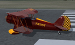
This is a repaint of the payware Alabeo WACO YMF-5 with a fictional US American registration and a revised interior in blue with brushed aluminum panel
| Filename: | WACO_YMF5_N876ST.zip |
| License: | Freeware |
| Added: | 21st October 2016, 03:59:36 |
| Downloads: | 130 |
| Author: | Bernd Koehling |
| Size: | 18.5 MB |
| Category: Flight Simulator 2004 - Original Aircraft | |
| Airspeed AS.5 Courier |
|
File Description:
FSDS V3.0 Airspeed Courier.
Has reflective Textures, usual animations, 2D Panel using all default Gauges plus a VC.
The Airspeed AS.5 Courier was a British six-seat single-engined light aircraft that saw some use as an airliner. Production aircraft were built by Airspeed (1934) Limited at Portsmouth. It first flew on 10 April 1933 and was the first British type with a retractable undercarriage to go into production, with a total of 16 built.
The prototype Courier was designed by Hessell Tiltman (co-founder of Airspeed Limited) and was built in 1932 by Airspeed at York for an attempt by Sir Alan Cobham to carry out a non-stop flight to India, using airborne refuelling. Airspeed moved from York to Portsmouth before the Courier G-ABXN first flew on 10 April 1933. The Courier was a wooden low-winged cabin monoplane; it had a novel feature for the day of a retractable undercarriage. The prototype was powered by an Armstrong Siddeley Lynx engine. The prototype had two minor accidents, in April 1933 at Portsmouth and in June 1933 at RAF Martlesham Heath. The aircraft was repaired on both occasions.
After a year spent perfecting airborne refuelling, Alan Cobham took off from Portsmouth in the prototype Courier on an attempted flight to India on 24 September 1934, being refuelled from a Handley Page W.10 before making a forced landing at Malta due to a broken throttle.
| Filename: | Airspeed_AS5_Courier.zip |
| License: | Freeware |
| Added: | 16th April 2017, 08:48:20 |
| Downloads: | 420 |
| Author: | Julian Higgs |
| Size: | 10.09 MB |
| Category: Combat Flight Simulator 1 and 2 - Aircraft | |
| Stinson L-5 Sentinel |
|
Images related to this file:
File Description:
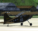
The Stinson L-5 Sentinel was a World War II era liaison aircraft used by all branches of the U.S. military and by the British Royal Air Force. Along with the Stinson L-1 Vigilant, the L-5 was the only other American liaison aircraft of World War II that was purpose-built for military use and had no civilian counterpart. All other military liaison airplanes adopted during World War II were lightly modified "off-the-shelf" civilian models.
| Filename: | Stinson_L5_Sentinel.zip |
| License: | Freeware |
| Added: | 13th June 2017, 15:25:06 |
| Downloads: | 144 |
| Author: | Peter Mercy/Gary Herbert |
| Size: | 9.48 MB |
| Category: Flight Simulator X - Aircraft Repaints, Textures and Modifications | |
| 5 Sansa Regional repaints |
|
Images related to this file:
File Description:

This is 5 repaints for the default Cessna Caravan in FSX
Tested with the normal FDE in Windows 7 and Bernt Stolle's improved version of the FDE with installation instructions for both
| Filename: | 5_Sansa_Regional_repaints.zip |
| License: | Freeware, limited distribution |
| Added: | 11th June 2018, 17:24:27 |
| Downloads: | 130 |
| Author: | Adam Loader |
| Size: | 13.57 MB |
| Category: Flight Simulator 2004 - Scenery | |
| Montréal, Québec Scenery 5 |
|
File Description:
This version of my Montréal sceneries adds the GoodYear blimp flying over Montréal (ai traffic) and also tall buildings on Nun's Island. Tom Constantine made the blimp fly around and Bill Lyons made the blimp. Thanks guys.
| Filename: | Montral_Qubec_Scenery_5.zip |
| License: | Freeware |
| Added: | 2nd April 2004, 21:43:16 |
| Downloads: | 4,608 |
| Author: | Leon Louis, Tom Constantine |
| Size: | 236.4 KB |
| Category: Flight Simulator 2004 - Original Aircraft | |
| Velocity XL-5 RG |
|
File Description:
The Velocity XL-5RG is a homebuilt that can carry four people while cruising at 200 knots. It has a canard stabilizer and a pusher prop. You are invited to repaint it as desired. It should look like the fun plane it is. The texture files are named for the parts. This is an original design by Tom Goodrick.
| Filename: | Velocity_XL5_RG.zip |
| License: | Freeware, limited distribution |
| Added: | 26th July 2004, 19:59:38 |
| Downloads: | 1,723 |
| Author: | Tom Goodrick |
| Size: | 623.14 KB |
| Category: Flight Simulator 2004 - Aircraft Repaints, Textures and Modifications | |
| JAL Group Pack #5 |
|
File Description:
The JALGroup consists of Japan Airlines, JALWays, Japan Asia Airways, Japan Transocean Air, JAL Express, J-Air, Japan Air Commuter, Harlequin Air, and the newly merged Japan Air System. These 9 packages represent the first release of the JALGroup fleet. This is Pack #5 of 9. The first release contains Japan Airlines and J-Air. Contents of the packs include only textures. Aircraft models are by PAI, AIA, and FSP and can be obtained at the associated sites. Repaints are by Frank Bass.
| Filename: | JAL_Group_Pack_5.zip |
| License: | Freeware |
| Added: | 18th August 2004, 15:01:43 |
| Downloads: | 1,274 |
| Author: | Frank Bass |
| Size: | 2.16 MB |
| Category: Flight Simulator 2004 - Original Aircraft | |
| Lockheed C-5 Galaxy |
|
File Description:
FS2004 The Lockheed C-5 Galaxy is a heavy logistics military transport aircraft designed to provide world-wide massive strategic airlift. The CONUS-based fleet can provide delivery of palletized, oversized and outsized cargo, as well as passengers or combat-ready troops, anywhere in the world on short notice.Self installing executable file. Developed by Mike Stone and painted by Garry Smith model includes 4 seperate liveies. Many more planes can be found at http://www.transloadairlines.com which has the largest VA fleet on the net.
| Filename: | Lockheed_C5_Galaxy.zip |
| License: | Freeware |
| Added: | 1st April 2005, 07:21:28 |
| Downloads: | 21,797 |
| Author: | Ken Paulick |
| Size: | 11.49 MB |
| Category: Flight Simulator 2002 - Panels | |
| Lockheed C-5 Galaxy |
|
File Description:
FS2002 panel - Lockeed C-5M Galaxy. The USAF is modernizing it's C-5B aircraft with a new glass cockpit and new GE powerplants. The panel is designed directly from Lockheed's modernization literature. Designed for 1024x768 resolution. Features an enhanced palette bitmap, full interior cockpit views plus a VFR view, night lit gauges, high resolution HSI with Rose and ARC modes, panel switches, and working MFDs. Also includes working throttles and the MS FS2002 GPS.
| Filename: | Lockheed_C5_Galaxy.zip |
| License: | Freeware, limited distribution |
| Added: | 18th August 2002, 18:38:19 |
| Downloads: | 4,254 |
| Author: | Paul Schwerdtfeger |
| Size: | 1.56 MB |
| Category: X-Plane - Scenery | |
| Hannover Scenery V6.21 #5 |
|
File Description:
Hannover Scenery Full Version
These files are 499 bitmaps reproducing the city of Hannover, Germany. They are computer-generated images that are as close to aerial photos as I could get it. These downloads are only the .bmp files, you will need the Hannover Scenery Mini Version, downloadable above, to get the airport, all custom objects and the .env file. Will look best with the City Replacement Textures installed. You can download them at my homepage at http://mitglied.lycos.de/n52e09/ .
File 5 of 10.
| Filename: | Hannover_Scenery_V621_5.zip |
| License: | Freeware, limited distribution |
| Added: | 6th December 2002, 18:55:38 |
| Downloads: | 1,196 |
| Author: | Christian Bothe |
| Size: | 8.71 MB |


© 2001-2026 AVSIM Online
All Rights Reserved
Privacy Policy |