
Where Flight Simulation Enthusiasts Gather from Around the World!
AVSIM Library - Search Results

| Category: Flight Simulator X - Scenery | |
| Slovenia - LOD11 (19 meters resolution) Mesh |

|
Images related to this file:
File Description:

Slovenia, no matter how small, is a country with wide variety of landscapes.
From flat lands in the North-Eastern part one can see lovely rolling hills in
southern regions and razor sharp edges of 8500 ft peaks of the Alps in the
North-Western region.
SRTM elevation data that was used and is provided as default FS X terrain simply
can't cope with the task of representing our terrain in at least a little close
to reality manner, shapes and altitudes of some of our nicest peaks are deformed
beyond recognition, our highest mt. Triglav is with 38 meters SRTM mesh falling
short by almost 3000 ft!
So Slovenia Scenery Team developed this 19 meters resolution using FSX compatible
tools for it's payware scenery, but after development of even finer mesh with 10
meters resolution, we decided to offer the original 19 meters mesh to general
fligt simulation public. Mesh is FS X only and is not compatible with FS9.
Even if released as freeware, this files were uploaded to only some selected
flight simulation sites and redistribution of this scenery is not allowed without
written permission from the authors.
File is packed into a convenient installer that should perform all of the actions
automatically, but, please, do read the License agreement and "Read me" file
included in the installation.
| Filename: | Slovenia__LOD11_19_meters_resolution_Mesh.zip |
| License: | Freeware, limited distribution |
| Added: | 15th May 2012, 19:03:19 |
| Downloads: | 2,214 |
| Author: | SST - Slovenia Scenery Team |
| Size: | 45.15 MB |
| Category: Flight Simulator 2004 - Scenery | |
| Nikolski (IKO), Nelson Lagoon (Z73), & Perryville (AK5) - Alaska, USA |
|
Images related to this file:
File Description:
These are villages in Alaska, spread out east and west of Dutch Harbor in the Aleutians and the peninsula, served by Grant Aviation regional flights from Dutch Harbor, Cold Bay, or King Salmon.
Nikolski is 115 miles west of Dutch Harbor at the western end of Umnak Island, which is just west of Unalaska, the large island adjacent to Dutch Harbor. Nikolski is small, with a population of perhaps only 20 now, and the main claim to fame is the wrecked Reeve Aleutian DC3 at the end of the runway. The runway is 3,500 feet of gravel aligned 08-26. Nelson Lagoon is on the north shore of the peninsula, 55 miles north of Sand Point and on a long spit of land that curves around to make the lagoon. There is no access except by boat or plane for the population of around 50. The airfield is a mile east of the village with a gravel runway 08-26, 4,000 feet long. Perryville is on the south shore of the peninsula, 65 miles east of Sand Point. The population is around 115, and the airfield is southwest of the town with the 3,500 feet of gravel runway aligned 02-20 beside the shore. There is a hangar on the apron, but no terminal building.
| Filename: | Nikolski_IKO_Nelson_Lagoon_Z73__Perryville_AK5__Al.zip |
| License: | Freeware, limited distribution |
| Added: | 14th March 2015, 13:27:53 |
| Downloads: | 257 |
| Author: | Roger Wensley |
| Size: | 11.45 MB |
| Category: Flight Simulator 2004 - Scenery | |
| Haines Junction CYHT in Yukon Territory Canada |
|
Images related to this file:
File Description:
Haines Junction is a village in the Yukon Territory, Canada, amid the Rocky Mountains and around 80 miles west of Whitehorse. It is sited at the junction of the Haines Highway and the Alaska Highway, hence the name. The village was established in 1942 when the Alaska Highway was under construction, and the Haines Highway was built over the Chilkat Pass to connect to the town of Haines on the Alaska coast.
The date of this scenery is, as usual, around 2010. At that time there was a regular service (not always a daily one, depending on the time of year) by Yukon Air North, and in this case it is by an ATR 42-300. There is a helicopter company based at the airfield, Trans North Helicopters, and there is also Kluane Glacier Air Tours, which, as the name suggests, takes you to a glacier so you can stroll around on ice. And then brings you back. The gravel runway is 5,000 feet long and aligned 04-22, and is lit, with PAPI at both ends. Right hand circuits are required for runway 04 as the terrain is not flat.
This post will be followed by two other airfields to the northwest, Silver City and Burwash, both of which are on or close to the Alaska Highway.
| Filename: | Haines_Junction_CYHT_in_Yukon_Territory_Canada.zip |
| License: | Freeware, limited distribution |
| Added: | 22nd January 2022, 21:53:16 |
| Downloads: | 117 |
| Author: | Roger Wensley |
| Size: | 20.46 MB |
| Category: Flight Simulator 2004 - Scenery | |
| Chignik Lake A79 and Port Heiden PAPH - Alaska, USA |
|
Images related to this file:
File Description:
These are two villages in Alaska, in the peninsula that is the start of the Aleutians. Both are east of Perryville, Chignik Lake by 30 miles on the south side of the peninsula and Port Heiden by 75 miles on the north coast. Both are served by Grant Aviation government-subsidised regional flights from King Salmon. Chignik Lake has a population of around 70. There are two buildings on the airfield, but passengers still wait in their car for the plane to arrive as there is no terminal building as such. The runway is 3,300 feet of gravel aligned 08-26, as are so many in this area. Port Heiden is on the north shore of the peninsula, and the population is around 100. FS9 showed the town as being large enough to house 10,000; the new landclass here reduces this to the actual 40 or so houses, one and a half miles south of the airport. The roads are still the FS9 originals, which are approximately in the right place but are brightly lit at night as I was too lazy. The main occupation is fishing. There are buildings on the airfield (mostly old, except for a garage building) but passengers again wait in their cars for the plane to arrive. The two runways are both gravel, and are 05-23 of 6,200 feet, and 13-31 of 4,400 feet.
| Filename: | Chignik_Lake_A79_and_Port_Heiden_PAPH__Alaska_USA.zip |
| License: | Freeware, limited distribution |
| Added: | 30th March 2015, 20:28:47 |
| Downloads: | 294 |
| Author: | Roger Wensley |
| Size: | 5.1 MB |
| Category: Flight Simulator 2004 - Scenery | |
| CYOC - Old Crow - Yukon Territory, Canada |
|
Images related to this file:
File Description:
Old Crow is in the far north of the Yukon Territory, Canada, 115 miles south of the nearest coastline and 30 miles east of the border with Alaska. The town has a population of less than 300 and the population are reliant on the caribou migration for an annual food supply replenishment. The fact that it is the only Yukon town that cannot be reached by car makes the airport important, and there are regular flights by Air North, the Yukon airline. They are included in the AI along with GA aircraft. I had several tries at matching up the Hawker Siddeley 748 with the right set of textures and I have included both here so that you do not have to go through the same torture. Thanks go to Hernan for sorting all that out, and for his textures. The airport is beside the town that is built along a bank of the Porcupine River. I have replicated the current shore line of the river that has cut a new channel at one end of the town, and I flattened the river as it was somewhat mountainous. The runway is gravel and just over 5,000 feet long, aligned 03-21. The terminal building is specific to Old Crow as I had photos, but the hangars are approximations and the village houses are only representational.
| Filename: | CYOC__Old_Crow__Yukon_Territory_Canada.zip |
| License: | Freeware, limited distribution |
| Added: | 5th December 2014, 13:31:46 |
| Downloads: | 373 |
| Author: | Roger Wensley |
| Size: | 7.58 MB |
| Category: Flight Simulator 2004 - Aircraft Repaints, Textures and Modifications | |
| North American F-86E "Sabre" (Canadair CL-13) Aeronautica Militare Italiana (Italian Air Force) Acrobatic Team "Lanceri Neri". |
|
File Description:
Textures Only for an aircraft of the Acrobatic Team "Lanceri Neri" (2nd Aerobrigata, Treviso, Italy 1958).
These textures require the FREEWARE original aircraft by Kazunori Ito. Installation instructions are included.
Repaint by Manuele Villa.
File name: F86E_LAN.ZIP
| Filename: | North_American_F86E_Sabre_Canadair_CL13_Aeronautic.zip |
| License: | Freeware |
| Added: | 23rd January 2006, 17:28:09 |
| Downloads: | 260 |
| Author: | Manuele Villa |
| Size: | 853.55 KB |
| Category: Flight Simulator X - Aircraft Repaints, Textures and Modifications | |
| SKHV North American T-6 Texan/Harvard Current Fleet (PH-LSK, PH-IIB, PH-MLM and PH-TBR) |
|
Images related to this file:
File Description:
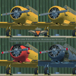
This packet includes 4 repaints of the current harvard fleet of the SKHV/KluHV
(Koninklijke Luchtmacht Historische Vlucht aka Royal Netherlands Air Force
Historical Flight). Stationed at Gilze Rijen Airbase in the Netherlands.
Featuring the PH-IIB (B-118), PH-LSK (B-64) PH-MLM (B-71) and PH-TBR (B-182)
For more info on the RNLAF Historical Flight please pay a visit to there homepage:
https://kluhv.nl/home-eng/
First three are from the RNLAF Flight School (VVO, Voortgezette Vlieg Opleiding)
at Gilze Rijen Airbase. The last one is from the so called "BAFO Vlucht"
(Photo Flight) stationed at Deelen Airbase until 1967.
The repaints are both on the outside and inside (Virtual cockpit & pilots).
As much detail is added as possible, accurate decals/stencils, also the
bump-map was modified, some latches removed some other added, also modified
the baggage compartment to look more like a Harvard then the Texan one.
Both PH-IIB and PH-LSK are updated since their initial release.
To be used with the payware A2A Simulations T-6 TEXAN/HARVARD.
Buy it here: https://a2asimulations.com/
The A2A repaintkit was used for making this repaint.
| Filename: | SKHV_North_American_T6_TexanHarvard_Current_Fleet_.zip |
| License: | Freeware |
| Added: | 21st May 2016, 20:38:29 |
| Downloads: | 396 |
| Author: | Marcel Ritzema |
| Size: | 132.94 MB |
| Category: Flight Simulator 2004 - Scenery | |
| Cordova Smith PACV & Municipal CKU in Alaska US |
|
Images related to this file:
File Description:
Cordova is on the south coast of Alaska, around 150 miles east of Anchorage and 45 miles south of Valdez. The town is mainly built on a small but relatively flat area between the east side of Prince William Sound and Eyak Lake, and has a population of around 2,350 in 2010, the approximate date of this scenery.
The Municipal Airfield CKU is on the north side of Eyak Lake to the east of Cordova, with the runway that is 1,800 feet of unlit gravel squeezed between the lake and the road that runs around the lake. The hangars and parking aprons are reached by taxiing across, and to some extent along, the road. Float planes are also taken from the lake to an apron to the west of the runway.
Cordova Airport PACV (named in the real world "Merle K. (Mudhole) Smith", and I will leave you to research this) is known as Cordova Smith in FS9 and is 10 miles to the east of the town on relatively flat ground between mountains to the north and the sea to the south. The runway is 8,080 feet of lit asphalt aligned 09-27 with ILS on runway 27 and VASI on both ends. The aprons are to the north side of the runway and are reached by back-taxiing; there are no taxiways parallel to the runway. The main apron serves Alaska Air via the western of two taxiways. The GA parking and hangars are mainly reached by using the eastern taxiway, though there is in fact a connecting taxiway between the two (for GA, but definitely not for airliner use). The taxiway further to the west serves the separated Alaska Coastguard apron and hangar, which is mainly for helicopter use. There is a nominally grass runway 1,900 feet long and aligned 16-34 to the south of the main runway; in fact it appears to be more gravel than grass. I have left this inactive as otherwise AI Alaska Air planes would be attempting to use this when the wind made it seem like a good idea.
The AI includes Alaska Air (twice a day) and also Coastguard helicopters, along with GA.
| Filename: | Cordova_Smith_PACV__Municipal_CKU_in_Alaska_US.zip |
| License: | Freeware, limited distribution |
| Added: | 22nd January 2022, 21:53:03 |
| Downloads: | 148 |
| Author: | Roger Wensley |
| Size: | 16.93 MB |
| Category: Flight Simulator X - Aircraft Repaints, Textures and Modifications | |
| Cessna C172P (SX-AEW) |
|
Images related to this file:
File Description:

This is a representation of SX-AEW, of the Dekeleia Aeroclub based in Tatoi LGTT, north of Athens. It is used both for training and for flights by all club members holding a PPL. It is also available for pleasure flights and initiation flights for non members. The real one also has extended fuel tank capacity for 6 hours endurance.
The actual plane is an older "P" model with carburetor equipped engine so there are several model differences from the "R" represented by A2A including antennae, and very different cockpit with no headrests and different door interior and instrument panel. The tinted cabin glass has been reproduced in the repaint.
| Filename: | Cessna_C172P_SXAEW.zip |
| License: | Freeware |
| Added: | 18th September 2013, 00:16:55 |
| Downloads: | 342 |
| Author: | Vassilios Dimoulas |
| Size: | 21.71 MB |
| Category: Flight Simulator X - Scenery | |
| X3SY - RAF Saltby - Leicestershire, England |
|
File Description:
RAF Saltby (ICAO X3SY)was a World War II airfield in Leicestershire, England. The airfield is located approximately 8 miles (13 km) northeast of Melton Mowbray; about 90 miles (140 km) north-northwestof London.
It was opened in 1942, and was used by both the Royal Air Force and United States Army Air Forces. During the war it was used primarily as a transport airfield. Like many airfields of the time it closed after the war in 1945 but kept in reserve until 1955.
Today the remains of the airfield are located on private property and, now known as Saltby Airfield, is used primarily for gliding.
Source: Wikipedia
| Filename: | X3SY__RAF_Saltby__Leicestershire_England.zip |
| License: | Freeware |
| Added: | 27th April 2016, 15:39:01 |
| Downloads: | 130 |
| Author: | Terry Boissel |
| Size: | 1.36 MB |


© 2001-2026 AVSIM Online
All Rights Reserved
Privacy Policy |