
Where Flight Simulation Enthusiasts Gather from Around the World!
AVSIM Library - Search Results

| Category: Flight Simulator X - Flight Plans | |
| Evacuate NOW!!!!! |

|
File Description:
For months Mount St Helens has shown sign of an emminent eruption. This adventure takes place just a
few days before the cataclismic explosion . You and your amphibian will fly to lakes and mountain hideouts.
The land is trembling and no one knows when the Volcano will blow its top!!!....Fly low and slow but don´t waste any time...Darth Vaskar the famous fisherman is waiting at lake Kooly, Ane Marie Burzz has parked her glider at Ranger Creek Field and is eager to see you, Aunt Milly Nowhety does not want to leave her cows at her farm by lake Moose and Natalio Bartuzzi has closed all gas pumps at the Mounty Gas Tanks Ltd and is waiting for you. Go get them pilot officer, no time for fooling around !!! ..Warning:If you are not experienced at bush flying and reading maps you should decline from this flight..It is too dangerous).
| Filename: | Evacuate_NOW.zip |
| License: | Freeware, limited distribution |
| Added: | 20th September 2007, 09:39:53 |
| Downloads: | 1,579 |
| Author: | Gera Godoy C |
| Size: | 95.66 KB |
| Category: Flight Simulator 2004 - Scenery | |
| Just For Fun 1 |
|
File Description:
Here's a little "just for fun" addition to make your GA flying in California a bit more interesting. Moffett Field, Mountain View, CA is a major landmark in the San Francisco Bay area. It is my understanding that NASA now controls this property and may convert all or a part of it to an Aviation Musuem. Microsoft elected to include the two ENORMOUS hangers that apparently were once used by the Navy to store Blimps and train crews. This scenery has the Goodyear Blimp (by Bill Lyons) doing touch and goes - taking off from inside of and landing in one of the immense hangers! Perhaps not very realistic but great fun to watch! Everything is included plus a recommendation to add John Townsend's great Hangar One scenery to the same airport. Works in FS2004 only. Just unzip to a Temp folder and read the simple installation instructions.
Created by David "Opa" Marshall - Plano, Texas
| Filename: | Just_For_Fun_1.zip |
| License: | Freeware |
| Added: | 29th June 2004, 03:00:05 |
| Downloads: | 2,077 |
| Author: | David Marshall |
| Size: | 192.53 KB |
| Category: Flight Simulator X - Scenery | |
| CYDA - Dawson Airport - Yukon, Canada |
|
Images related to this file:
File Description:
FSX Scenery - Dawson City Airport (IATA: YDA, ICAO: CYDA) is located 8 nautical miles (15 km; 9.2 mi) east of Dawson City, Yukon, Canada, in the Klondike River valley, and is operated by the Yukon government. It has a terminal building and like most airports in its class, the runway is not paved. The gravel runway is 5,006 ft (1,526 m) long and at an elevation of 1,215 ft (370 m). A number of studies have recommended moving the airport or realigning the runway as it is in a narrow mountain valley. The airport is classified as an airport of entry by Nav Canada and is staffed by the Canada Border Services Agency (CBSA). CBSA officers at this airport can normally handle aircraft with up to 15 passengers, but are equipped to handle daily Boeing 737 charters between Dawson City and Fairbanks (Fairbanks International Airport) during the peak summer tourism season. For your flying pleasure by John B. Loney, Jr.
| Filename: | CYDA__Dawson_Airport__Yukon_Canada.zip |
| License: | Freeware, limited distribution |
| Added: | 7th April 2016, 17:20:42 |
| Downloads: | 901 |
| Author: | John B. Loney, Jr. |
| Size: | 13.92 MB |
| Category: Flight Simulator 2004 - Scenery | |
| Williams Lake CYWL |
|
Images related to this file:
File Description:
Founded in 1860, Williams Lake is located in the beautiful central British Columbia region known as the Cariboo. With a population of about 11,000, Williams Lake is the largest urban center between Kamloops and Prince George. The airport has one 7,000' (2,100m) runway and is served by Central Mountain Air and Pacific Coastal Airways.
This complete rebuild of CYWL features all new taxiways, aprons and buildings, an accurate custom terminal building, and the usual fences, trees, ramp objects, etc. Many thanks to Shawn Lund, Air Attack Officer, BC Wildfire Management Branch, Kamloops Fire Centre, for the photos of the terminal building and his permission to use them. Included are the Nav Canada aerodrome diagram and the two instrument approach plates. (These approach plates are out of date and obviously NOT for real world use.)
This scenery was designed for use with Ultimate Terrain and was not tested in the default scenery. It may or may not work in FSX.
| Filename: | Williams_Lake_CYWL.zip |
| License: | Freeware |
| Added: | 21st December 2010, 07:17:50 |
| Downloads: | 1,071 |
| Author: | Sidney Schwartz & Peter Ham |
| Size: | 2.07 MB |
| Category: Flight Simulator 2004 - Scenery | |
| Chilanko Lodge CBX3 in British Columbia Canada version 2 |
|
Images related to this file:
File Description:
This is a revised post of Chilanko Lodge, which is an airstrip that serves the Lodge of the same name on the beach of One Eye Lake. The lake is close to the eastern side of the Coastal Range, 30 miles south of Nimpo Lake and 30 miles west of Puntzi Mountain, both previous posts. There is also a dock for float planes. The runway is 2,900 feet of gravel aligned 10-28, unlit, and at 2,972 feet above sea level. I remade this scenery as I was not very satisfied with the surrounding terrain, and then there was a reported terrain level problem. It is now better than the first time around, in my opinion anyway. I have posted it as version 2 of Chilanko Lodge CBX3, but I suggest that you add this to your "BC airfields" folder as previously suggested. Up to you. If you find a defect, email me.
| Filename: | Chilanko_Lodge_CBX3_in_British_Columbia_Canada_ver.zip |
| License: | Freeware, limited distribution |
| Added: | 20th November 2020, 23:29:53 |
| Downloads: | 78 |
| Author: | Roger Wensley |
| Size: | 8.61 MB |
| Category: Flight Simulator 2004 - Scenery | |
| Southeast Farallon Islands Version 3 |
|
File Description:
Complete download: Surf height fix. Also new island texture map. These islands were mysteriously absent from the FS2004 default scenery, probably owing to their small size. When I went to look for them I found a small mountain of water instead of the islands. Most people don't seem to be aware of the Farallon Islands. Located off the coast of California, near San Francisco, they are home to thousands of birds, seals, and some of the largest Great White sharks known to man. All of this is within a very short distance of the city. Today, it is a wildlife refuge and is off limits to visitation by the general public. Those of you interested in more info might check out "The Devil's Teeth" by Susan Casey. This island is actually a scenery object. As such it doesn't have a landable surface. Future versions will have a helicopter pad, a lighthouse, and the 100 year old houses used by researchers.
| Filename: | Southeast_Farallon_Islands_Version_3.zip |
| License: | Freeware, limited distribution |
| Added: | 22nd November 2005, 19:05:56 |
| Downloads: | 1,097 |
| Author: | Glen Gordon (Prof K.) |
| Size: | 1.38 MB |
| Category: Flight Simulator 2004 - Scenery | |
| Boulder (KBDU) / Longmont / Loveland, Colorado, Photo-Scenery (FS9 & FSX) |
|
Images related to this file:
File Description:

Boulder is situated where the Rocky Mountains meet the Great Plains. Just west of the city are imposing slabs of sedimentary stone tilted up on the foothills, known as Flatirons. Located at the base of the foothills is Boulder's main campus of the University of Colarado which is clearly visible from the sky. Longmont is home of the Denver ARTCC (Air Route Traffic Control Center) which controls all flights in the upper airspace of most of Colorado and parts of adjoining states. To explore the scenery depart from Boulder (KBDU) and head northeast. Extends my Rocky Mountain Park scenery to the east and my Denver scenery to the north. Provides another 3.500 sq km in 4.7m/pix quality. High resolution versions for FS9 and FSX (much sharper, but larger and multiple downloads) are available at www.blueskyscenery.com/GNB_East.html . The screenies are taken from the high-res versions, so expect this version to be slightly more blurry. YourDonation@Work: Dedicated to Senges and Eric.
| Filename: | Boulder_KBDU__Longmont__Loveland_Colorado_PhotoSce.zip |
| License: | Freeware, limited distribution |
| Added: | 28th December 2009, 20:14:09 |
| Downloads: | 2,385 |
| Author: | Gottfried Razek - blueskyscenery.com |
| Size: | 94.26 MB |
| Category: Prepar3D V1-4 - Aircraft Repaints, Textures and Modifications | |
| USAAF 3X-W "That's all, Brother!" Douglas C-47 (292847) |
|
Images related to this file:
File Description:

This folder contains a repaint for version 3.14 of the Douglas C-47 by Manfred Jahn and colleagues in the colors of C-47A 42-92847 3X-W "That's All, Brother!"of the 438th TCG, based in Greenham Common, England. It was the aircraft that was the lead plane with the parachute droppings on the night of D-Day, dropping men of 502nd PIR of the 101st Airborne Division arond 00:48. It then returned to Greenham Common and later that day pulled a glider to Normandy to reinforce the 82nd Airborne Division. Later it evacuated wounded from France, took part in Operation Market Garden, flew supplies to Bastogne, took part in Operation Varsity, before returning to the US in 1945. It passed through the hands of several private owners, is rumoured to have flwon for the CIA, and was restored as an AC-47 gunship by the Aero heritage Museum in 2004.. In 2008 it went to Basler for conversion to a turboprop BT-67, when somebody recognised the significance of this aircraft. A kickstarter campaign secured the purchase by the Commemorative Air Force, who are planning to restore her to her D-Day configuration. More details on this, including D-Day footage, can be seen here: http://ww2live.com/en/content/world-war-2-forgotten-d-day-bird-s-all-brother-will-be-restored-and-itll-fly-thanks. Repaint by Jan Kees Blom for Manfred Jahn's C-47 version 3, based on the paintkit by Gman5250.
| Filename: | USAAF_3XW_Thats_all_Brother_Douglas_C47_292847.zip |
| License: | Freeware |
| Added: | 9th September 2018, 03:44:19 |
| Downloads: | 618 |
| Author: | Jan Kees Blom |
| Size: | 9.85 MB |
| Category: Microsoft Flight Simulator (2020) - Scenery Design | |
| MSFS 2020 object library with 200+ models ranging from towers hangars to cones (v10 12 extra models) |
|
Images related to this file:
File Description:
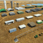
Object libraries for scenery developers (version 10 - improvements on curved surfaces + 10 lights(improved) + 3 windsocks + 3 animals + 5 animated people + 10 fuel_area +stable +fire_tower + 28 new fences + church + sheds). All objects in these libraries will be used in my own sceneries and the result of 100s hrs of effort. All objects from the real world. All objects use LOD (Level Of Detail) to keep frame rates high. Final long distance models have a large triangle added below ground to stop them disappearing in the distance. PBR materials used extensively. Included are 2 PDF files with photos of every object to make selection easy. Republish these files in any freeware scenery if required. READ "read me library instructions" before using.
---------------library1v10-cbj
Cones x4 Gables x3
Church x1
Fences (10 types farm chainlink x4 mesh x2 horse hand-rail paling cattle_grid) x94
Flag pole x1
Fuel_Signs_ x6
Fuel_area_pipes x2
Gas (petrol) station x3
Gliders x4
Glider trailers x4
Grain storage hoppers silos x 4
Power poles x2
Rail platforms station x5
Rail locomotive passenger_carriage grain_hoppers x5
Tower_forest_observation
Towers_radio x6
Weather station small x4
Windsock x3 Windsock-light x1
-------------library2v10-cbj
Animals - Cows x2 Sheep
Grain bunkers - large piles of grain covered with canvas x5
Hangars small airfield x15
Medical transfer station (building) x2
Obstacle-light x10
People x5 Men Women
Pivot irrigator x3
Sheds x10
Shelters x2
Terminals - small airfield x12
Water tanks x3
Towers water x4
Tractors farm x3
Water tanks x3
| Filename: | MSFS_2020_object_library_with_200_models_ranging_f.zip |
| License: | Freeware |
| Added: | 6th March 2022, 19:34:52 |
| Downloads: | 391 |
| Author: | COLIN JEFFERY |
| Size: | 198.25 MB |
| Category: Prepar3D V1-4 - Scenery | |
| Sauze and Val Susa (TO) Italy N45.05.52 E7.20.35 to N45.02.01 E6.50.00 |
|
File Description:
Sauze and Val Susa (TO) Italy Abbey of San Michele della Chiusa, is an architectural complex perched on the summit of the Pirchiriano mountain, at the mouth of the valley of Susa N45.05.52 E7.20.35.
The Fort of Exilles, N45.05.59 E6.56.10 is one of the most important defensive systems in Piedmont. Its position in the middle of a stretch of the high Susa Valley made it a strategic one. Around the Fort were born through the centuries many legends, but perhaps the most famous of all, is that related to a mysterious character the Iron Mask, better described by Alexandre Dumas in the novel of the same name. The village of Sauze d'Oulx N45.02.01 E6.50.00 includes the old alpine village where a large circular hotel built in the 1960's as a holiday center for the FIAT workers in the nearby Turin and higher, the new part formed by villas and hotels. Important VFR points for approching airport airport Torino or Val di Susa.
Within the downloaded package you will find readme files for scenery installation. Good fly VFR. Pasquale Marrulli.
| Filename: | Sauze_and_Val_Susa_TO_Italy_N450552_E72035_to_N450201_E65000.zip |
| License: | Freeware |
| Added: | 4th November 2017, 16:47:39 |
| Downloads: | 175 |
| Author: | Pasquale Marrulli |
| Size: | 15.99 KB |
© 2001-2026 AVSIM Online
All Rights Reserved
Privacy Policy |