
Where Flight Simulation Enthusiasts Gather from Around the World!
AVSIM Library - Search Results

| Category: Flight Simulator 2004 - Scenery | |
| Bora Bora Airport, French Polynesia, NTTB |

|
File Description:
The Bora Bora airport is located on one of the Motus, which surround the Island of Bora Bora. The Motus are raised coral reefs which act as break waters, and create the beautiful turquoise lagoons which surround the French Polynesian Islands. This scenery is a complete remake of the original, and is now much more accurate as to what the airport looks like. It contains the main terminal, a fire station attached to the tower with fuel tanks, open air hangar structures, two helipads, and wood stairs taking you down to the boat docks where you are transported to the main island. This is one of the most unique French Polynesian Islands with it's beautiful and interesting mountain structure. Using the terrain mesh by Rolf Keibel and John Applegate will tremendously enhance this part of the world in FS. It is available at Flightsim under the name fpsimesh.zip. Afcad by Ray Smith is also included.
| Filename: | Bora_Bora_Airport_French_Polynesia_NTTB.zip |
| License: | Freeware |
| Added: | 25th April 2004, 01:39:17 |
| Downloads: | 19,350 |
| Author: | Bill Melichar |
| Size: | 3.11 MB |
| Category: Flight Simulator 2002 - Miscellaneous Files | |
| Albuquerque Sectional Chart |
|
File Description:
Fly eastbound from Phoenix and visit Area 51 and Roswell (where SETI was "born"), Alamogordo, White Sands National Monument, Trinity Site (where the Manhattan Project tested the first nuclear device), Albuquerque (the state´s capital city), Lincoln County (where Billy the Kid was shot), the Mescalero Reservation (great skiing at Sierra Blanca south of the White Mountain Wilderness Area) and Capitan, Birthplace of Smokey the Bear. Flying VFR in this kind of countryside isn´t easy, as there aren´t all that many landmarks to rely on. Maybe this chart is of some assistance to you. You may use it "as is" without any other software, but it will develop its full potential if used as moving map with SimSystem´s FSFlightMax or FSGarmin. It wouldn´t have been possible to offer this chart without Richard Harvey and his love to flightsimming, so please consider this file to be "donationware" and make a however small contribution to the Richard Harvey Endowed Scholarship.
| Filename: | Albuquerque_Sectional_Chart.zip |
| License: | Check within download |
| Added: | 29th March 2003, 04:15:12 |
| Downloads: | 2,137 |
| Author: | Uwe Rademacher |
| Size: | 15.09 MB |
| Category: Flight Simulator 2004 - Aircraft Repaints, Textures and Modifications | |
| Air Glaciers - HTAI Beech and Mike Cronin Pilatus |
|
File Description:
This package lets you have a Beech holiday in the mountains. Air Glaciers operates Beechcraft King Airs from Sion to various destinations closer to the sea. They are frequent visitors to Corsica across to Krk (Rijeka) from their mountain lair. This package contains three Beech King Air repaints based on the Henry Tomkiewicz AI King Air 200 (4-blade, strakes) and, one they've got you to Sion there are three Pilatus Turbo Porters (based on the Mike Cronin low-poly PC6) to carry you onward into the mountains.
The King Airs have accurate weekly flightplans (plus a few charters) and the Turbo Porters have very simple plans that service nearby airports. The effect at Sion is quite nice. If you want the Turbo Porters to service altiports you'll need to devise your own plans and find a way of landing AI on steep slopes! If you manage that, you can start on the choppers ...
Now I'm going on the piste ... (aka having a beer ...). Enjoy!
| Filename: | Air_Glaciers__HTAI_Beech_and_Mike_Cronin_Pilatus.zip |
| License: | Freeware, limited distribution |
| Added: | 18th February 2005, 20:17:51 |
| Downloads: | 1,755 |
| Author: | Matthew Ministry |
| Size: | 593.1 KB |
| Category: Flight Simulator X - Flight Plans | |
| Daredevil Rescue |
|
File Description:
Dirko Marik, well known mountanier from Poland, joined the
"Golden Lake" expedition to climb some of the highest mountains
in New Zealand. Now he lies near his tent in pain and with a very
high chance of dying if he is not taken as fast as possible to a
hospital...
This morning while climbing near the lake camp Dirko moved a rock and
to his surprise a large bluish snake jumped an bit him in his left
leg, his friends brought him down to the camp and inmediatly called for
help over the radio link. The call was transfered to the Mountain Police
outpost in Glentaner (NZGT) where a flight has been set up.....the main
problem is that the target lake is very small and is located in a very
deep gorge, so a small amphibian or floatplane that can land very slowly will
have to be used...........are you ready for the task???
| Filename: | Daredevil_Rescue.zip |
| License: | Freeware |
| Added: | 15th July 2007, 22:39:05 |
| Downloads: | 1,331 |
| Author: | Gera Godoy C |
| Size: | 172.07 KB |
| Category: Flight Simulator X - Flight Plans | |
| Mine Supervisor´s Nightmare |
|
File Description:
Chile´s production of Copper is fantastic. The ore is all over the country
and many Chilean Mining Companies have their mines in places that even
goats stay away from.
Igor del Monte, senior "Bucaton Minas Ltd" chief deep mines supervisor leaves
early tomorrow to visit four of the companies mines. To him and to pilots that
fly him to these forsaken places is really why they get paid what they do. This
round is yours if you dare.... Chief company pilot, Adri Penelope, lets his pilots
volunteer for this flight--he is married to one pilot´s widow who overran the landing
area in Mine 1 . She was 28 when Frankie Balon tasted the copper dust.
This flight is considered of the outmost danger----there are no airfields where the mines are
so landings and take offs are done in roads by the mines....Are you volunteering for
tomorrow´s flight?????...Read instructions really well and may the Copper Mountain god
bless you during the flight.
| Filename: | Mine_Supervisors_Nightmare.zip |
| License: | Freeware, limited distribution |
| Added: | 21st February 2008, 09:53:58 |
| Downloads: | 759 |
| Author: | Gera Godoy C |
| Size: | 1.11 MB |
| Category: Flight Simulator X - Scenery | |
| Lost River ASU Observatories |
|
Images related to this file:
File Description:
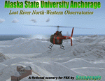
This is a fictitous scenery of the Alaska State University operated North-Western observatories.
It is located near LSR_Lost River and AK45_Lost River_2 on the Western coast of Alaska.
LSR, AK45 and KPC_Port Clarence have been upgraded with hangers and various objects.
LSR, AK45 and the (2) mountain top observatories have been upgraded with helipads along with various ground vehicles including snocats, aircraft, misc buildings and hangers. The main observatory complex has a main rooftop pad and a heli-tower. These helipads were designed for heli practice. some are on the ground and others are a bit more challenging.
There is a map included which shows the locations of the observatory complexes in relation to the airports. There is also a small research facility located to the east which is indicated on the map. This fictional scenery was design with default FSX 3D objects and (1) addon library, fa_ez-arctic_set by Finney Air, Robert Finnegan.
| Filename: | Lost_River_ASU_Observatories.zip |
| License: | Freeware |
| Added: | 11th November 2009, 19:11:39 |
| Downloads: | 557 |
| Author: | Tim Durham |
| Size: | 3.41 MB |
| Category: Flight Simulator 2004 - Original Aircraft | |
| Luftwaffe, D.F.S.-230 , Assault Glider V0.2 |
|
Images related to this file:
File Description:

This German assault/freight glider, developed by the DFS (Deutsche Forschungsanstalt fur Segelflug / German Research Institute for Sailplane Flight), was used for the first time during the operation against the Belgian Fort Eben Emael near Maastrich (May 10, 1940). They were also used during Krete invasion (Maleme, 1941), in the Western Desert and on the Russian Front for transport purposes. Were used also to deliver the Otto Skorzeny's commandos against the Gran Sasso mountain-top hotel that was used to hold Mussolini (Sept.12, 1943).
The Royal Italian Air Force (Regia Aeronautica) received from the Luftwaffe almost 20 '230 and 4 Gotha Go-242, but they were used only for training.
UPGRADED VERSION, now with functionally jettisonable undercarriage, drag chute and revised flight dynamics. Complete aircraft. Original GMAX hi-res model, features the usual moving parts, such as all flight controls, canopy and doors (5 different versions); Five different liveries (4 'LW' +1 "R.A.'); multiview 2D panel (NO VC). Created by Manuele Villa.
| Filename: | Luftwaffe_DFS230__Assault_Glider_V02.zip |
| License: | Freeware |
| Added: | 6th May 2010, 08:39:29 |
| Downloads: | 2,274 |
| Author: | Manuele Villa |
| Size: | 19.69 MB |
| Category: Flight Simulator X - Scenery | |
| Bella Coola Valley Landscape Enhancements |
|
File Description:
One of the most spectacular watersheds of British Columbia's Midcoast, the Bella Coola Valley looks pretty boring in its default FSX rendition and the oddly shaped default Bella Coola River cuts deep into the terrain. These files provide a terrain mesh made from CDED1 0.75-arcsec data (multi-LOD, with maximum resolution of 38-m grid spacing), updated land class, water class, and seasons files, and accurate placements of lakes, rivers, streams, roads, and bridges. Also added are the glaciers of the Monarch Mountain Icefield as well as several forestry roads and clearcuts in the side valleys. Main roads have vehicle traffic moving in both directions. Coverage area is N51*45'-52*40' and W125*35'-127*25'. These files are fully compatible with other landscape enhancements for FSX, such as FS Genesis North America terrain mesh, Cloud 9's X-class, Adam Mill's ground texture replacements, or Flight1's Ultimate Terrain Canada/Alaska.
| Filename: | Bella_Coola_Valley_Landscape_Enhancements.zip |
| License: | Freeware, limited distribution |
| Added: | 24th February 2007, 08:27:54 |
| Downloads: | 12,654 |
| Author: | Holger Sandmann |
| Size: | 15.68 MB |
| Category: Flight Simulator 2004 - Scenery | |
| Turangi Airfield, New Zealand. NZTN. Version-2 UPDATE and FIX. |
|
File Description:
Welcome to Turangi Airfield, 1nm North of the township of Turangi, at the southern end of the
beautiful Lake Taupo, in the central North Island of New Zealand.
The airfield is home to the Turangi Aero Club, and is served by Mountain Air, undertaking tourist flights
around the National Park and central North Island volcanoes, and flights to the Chateau and skifields
at Mount Ruapehu.
This scenery is built to fit into the freeware "Turangi" photoreal area scenery by Robin Corn, freely available
from avsim.com, filename...... godzoneturangi.zip .
This version corrects an error i made in the first scenery, when i accidentally mixed some pictures of another airfield
in with the Turangi pictures i was using for building. It corrects the type of buildings, and their locations on the airfield.
Update also adds a few other detail changes and additions.
This is a TOTAL replacement for my previous scenery. Requires some EZ Scenery Object Sets (see INSTALL instructions for details).
| Filename: | Turangi_Airfield_New_Zealand__NZTN__Version2_UPDAT.zip |
| License: | Freeware, limited distribution |
| Added: | 13th November 2008, 12:52:09 |
| Downloads: | 733 |
| Author: | Lawrie Roache |
| Size: | 549.77 KB |
| Category: Prepar3D V1-4 - Scenery | |
| Cascia Peruglia Umbria Italy N42.43.08 E12.00.45 |
|
File Description:
Cascia Peruglia Umbria Italy N42.43.08 E12.00.45 The municipality is located on the border with Lazio (province of Rieti), in the lower province of Perugia, in the low mountain territory, little more than hilly in Valnerina. To the south, the territory extends to higher altitudes towards the Leonessa plateau. The territory of Cascia presents, together with that of Norcia, the highest level of seismicity in Umbria. Throughout history, the town has been the victim of some particularly destructive earthquakes. In addition to the aforementioned catastrophic event of the first century BC we remember those of the autumn-winter of 1300, November 1599 and January 1703. The latter, particularly bloody, caused the death of over 700 people. The city is famous for the beautiful church of Santa Rita da Cascia where they rest the mortal remains of the Saint.
Within the downloaded package you will find readme files for scenery installation. Good fly VFR. Pasquale Marrulli.
| Filename: | Cascia_Peruglia_Umbria_Italy_N424308_E120045.zip |
| License: | Freeware |
| Added: | 4th May 2018, 04:42:41 |
| Downloads: | 155 |
| Author: | Pasquale Marrulli |
| Size: | 115.05 KB |
© 2001-2026 AVSIM Online
All Rights Reserved
Privacy Policy |