
Where Flight Simulation Enthusiasts Gather from Around the World!
AVSIM Library - Search Results

| Category: Prepar3D V1-4 - Aircraft Repaints, Textures and Modifications | |
| A2A P-51D Mustang Civilian 7Q-BTY Malawi |

|
Images related to this file:
File Description:
This is an imaginary repaint for A2A P-51D Mustang Civilian to fly in Africa (great in Orbx Open LC Africa) over Malawi and around.
The pilot's name on the fuselage is fictive : Jok Lubanga is the name of the "mountain evil spirit" (and the name of 2 beautiful songs by Geaffrey Oryema)
Made by Jean Marc with Gimp and FSRepaint v2.25, from the initial repaint 'USAAF Old Crow Early W' by Tom Weiss
(PS : on the screenshots, a few area have wrong reflections with sun light due to alpha channels inaccurate colors on the texture dds : these have been corrected on the enclosed dds files and should not appear at present)
| Filename: | A2A_P51D_Mustang_Civilian_7QBTY_Malawi.zip |
| License: | Freeware |
| Added: | 5th August 2020, 19:16:43 |
| Downloads: | 28 |
| Author: | jean marc |
| Size: | 27.17 MB |
| Category: Flight Simulator X - Aircraft Repaints, Textures and Modifications | |
| Aerosoft F-16C MO 91-0386 389FS Repaint Textures |
|
Images related to this file:
File Description:
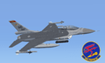
Aerosoft F-16C MO 92-0386 "389FS" Repaint Textures. This repaint for the Aerosoft F-16 depicts Mountain Home F-16C 92-0386 in the special "389FS" paint scheme. This repaint has a few extra "custom items" in it. For instance I noticed that the Falcon emblem behind the cockpit was different on the 389FS jets, that it had a lightning bolt in its' claws, so I custom painted that on there. I also noticed those jets had the old "3-tone grey" camo scheme, so that's on there too. Plus a bunch of other little things here and there that help with the overall look. Have fun zooming through the Sawtooth Mtns!
| Filename: | Aerosoft_F16C_MO_910386_389FS_Repaint_Textures.zip |
| License: | Freeware |
| Added: | 14th May 2023, 16:31:53 |
| Downloads: | 58 |
| Author: | Daniel Gregory |
| Size: | 9.62 MB |
| Category: Flight Simulator 2004 - Scenery | |
| VFR of Lario, Area D1 - Como lake, Italy |
|
Images related to this file:
File Description:

This is the sixth scenery of the "VFR of Lario" project, made with photorealistic terrain and some 3D GMax realistic objects. This scenery covers approximately an area of 7.5x6 kmt, from Val Cavargna mountains (NW) to Acquaseria/Sant'Abbondio (NE), and from Galbiga mountain (SW) to Cadenabbia/Griante (SE) and includes the NLC piers of Cadenabbia and Menaggio; it includes several dedicated buildings as S. Rocco church (Griante), NLC ticket-office, statue of Bowler and hotel Britannia (Cadenabbia), villa La Gaeta (S. Siro), Finalcial Police old building, NLC boarding square and Grand Hotel Menaggio (Menaggio). Motor ship Orione at Menaggio pier together with other minor boats and docks alongside the coast. Two little libraries that use default textures are added.
| Filename: | VFR_of_Lario_Area_D1__Como_lake_Italy.zip |
| License: | Freeware |
| Added: | 27th May 2012, 23:32:01 |
| Downloads: | 1,319 |
| Author: | Aldo Della Vedova, Daniele Lanfranchi, Gian Mario Verga, Diego Caligiuri |
| Size: | 13.34 MB |
| Category: Flight Simulator 2002 - Scenery | |
| Canadian Rockies LOD 8 Mesh |
|
File Description:
As many of you know, NASA and the JPL have recently released 3 arc second (90 meter) elevation data for most of North America. The enclosed bgl file is intended to display the data more or less as it is, covering the Canadian Rocky Mountain National Parks.
Many people are probably curious about the new data, and this project has been an attempt to satisfy that curiosity in a spectacular area so far unpublished on the internet.
The data yields scenery in FS 2002 that far surpasses the default scenery. The area is also well visited by many people from around the world so I expect that this terrain will be recognizable to more than a few.
| Filename: | Canadian_Rockies_LOD_8_Mesh.zip |
| License: | Freeware |
| Added: | 9th April 2003, 02:36:31 |
| Downloads: | 1,966 |
| Author: | Gary Snow |
| Size: | 4.26 MB |
| Category: Flight Simulator 2002 - Flight Plans | |
| 38RTWest |
|
File Description:
An FS2002 GPS flight Plan. The 38th in a series of Round the World flight plans for the FS2002 default scenery. Depart Thoise (Z13Q) runway 29, India and arrive 1 hour 24 minutes later at Kabul (OAKB) runway 29, Afghanistan. A very scenic flight. A climb up a valley followed by a tour between the mountain peaks and descent into a valley for the approach is featured. Keep a sharp lookout for you know who, there is a substantial reward still on offer. A VFR finals is featured (hand holding instructions given). The flight briefing (Word and text) is for a B737-400, it contains climb, cruise, top of descent and fuel loading details, waypoint timings and destination details.
| Filename: | 38RTWest.zip |
| License: | Freeware |
| Added: | 10th August 2002, 15:47:22 |
| Downloads: | 783 |
| Author: | The Ancient Brit |
| Size: | 26.97 KB |
| Category: Flight Simulator 2004 - Flight Plans | |
| Nepal Flights |
|
File Description:
Welcome to these five Flights over The Himalaya mountains in Nepal among witch one will bring you over Mount Everest 'The Roof of the World', the highest mountain in the world.
You must fly FS2004 with FSNavigator installed. The two mast shown on the top of Mount Everest on one of the snapshots is non existence!!-.
You and your friends can enjoy these adventures, it's absolutely free, but don't try to make money out of it. Remember there has been spend lot's of hours making the Flights and the author have all the rights.
If you have any questions, suggestions or else, feel free to write to me Mikael Seedorff.
[email protected].
| Filename: | Nepal_Flights.zip |
| License: | Freeware |
| Added: | 10th October 2007, 12:39:54 |
| Downloads: | 517 |
| Author: | Mikael Seedorff |
| Size: | 458.88 KB |
| Category: Flight Simulator X - Scenery | |
| OAMS – German Camp Marmal ISAF |
|
File Description:
As of early January 2002 approximately 200 soldiers from the 10th Mountain Division, known as Task Force Commando, were operating from the Mazar-e-Sharif Airfield. The Mazar-e-Sharif Airfield's runway has a length of 3,100 meters/10,500 feet.
Germany took command of the International Security Assistance Force’s Regional Area North at the end of March 2006. The airfield functions as main hub for the exchange of personnel as well as air cargo for the international stabilization and peace support forces in Northern Afghanistan. The German government has German Camp Marmal contributed 53 million euros to reconstruction work at Mazari-Sharif airport. Here is the tribute for the german soldiers in afghanistan.
| Filename: | OAMS__German_Camp_Marmal_ISAF.zip |
| License: | Freeware |
| Added: | 1st October 2007, 21:33:18 |
| Downloads: | 1,577 |
| Author: | Volker Gießübl |
| Size: | 9.6 MB |
| Category: Flight Simulator 2004 - Flight Plans | |
| SIDSTARS Palm Springs Intl (KPSP) |
|
File Description:
Procedures based on current cycle (0803 13Mar-10Apr) FAA Digital Aeronautical Information and Terminal Procedure Publications (Charts Included). Remember Sonny Bono (of Sonny and Cher)? He was mayor here before his hard landing with a tree on a ski slope and now there is the SBONO STAR and UBABE fix (You Got Me Babe). The airport at 477 ft is right next to a 10,834 ft mountain; hence, no ILS but two RNP approaches get Alaska Airlines 737-900's into here (but no 744's). I've included 13 NOATC departure routes for the commonly filed departures, and complete description of each procedure in the readme and the header of the kpsp.txt file. For PMDG Only
| Filename: | SIDSTARS_Palm_Springs_Intl_KPSP.zip |
| License: | Freeware, limited distribution |
| Added: | 15th March 2008, 23:40:05 |
| Downloads: | 261 |
| Author: | Dan Downs |
| Size: | 2.33 MB |
| Category: Flight Simulator 2004 - AFCAD Files | |
| VNKT Tribhuvan International Airport, Kathmandu, Nepal |
|
File Description:
This AF2 file is based on the googlemaps image.
As I spent time on this "getting it right" a while back, I thought I may as well share it. Parking is provided for all aviation (both civil, military and ga). I recommend World of AI, and also Project AI (older) packages to get some of the local airlines active. There is also a Nepali army package on Avsim that I use to good effect, and for which I have provided parking spaces.
I have closed operations in the rwy 20 direction to prevent approaches through a mountain. Rwy 02 operations work much better, given the limitations that such a restrictive airfield presents to the FS9 AI "engine".
| Filename: | VNKT_Tribhuvan_International_Airport_Kathmandu_Nep.zip |
| License: | Freeware |
| Added: | 9th April 2009, 16:19:54 |
| Downloads: | 1,007 |
| Author: | Dan Foster |
| Size: | 5.78 KB |
| Category: Flight Simulator X - Scenery | |
| Helena Regional Airport (KHLN) |
|
Images related to this file:
File Description:
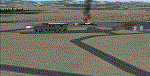
Welcome to Helena Regional Airport for FSX! All the structures are custom. Airport vehicles use
the proper vehicle paths and do not use taxiways. The Rocky Mountain Emergency Services fire training
facility is depicted and there is a training session in progress. Be sure to visit Mustard Mickey's
before your travels take you through the scenic Montana wilderness. Stop by Vetter Aviation and thank
Brent for his over two decades of service to the aviation industry.
As with all my work the structures are original work. Some are accurate, some are workups based on what
I think they might look like.
Three scenery complexity levels are used (normal,dense, and very dense). More eye candy appears with each
increase.
| Filename: | Helena_Regional_Airport_KHLN.zip |
| License: | Freeware, limited distribution |
| Added: | 6th December 2019, 17:13:13 |
| Downloads: | 402 |
| Author: | Brett Delana |
| Size: | 6.29 MB |
© 2001-2026 AVSIM Online
All Rights Reserved
Privacy Policy |