
Where Flight Simulation Enthusiasts Gather from Around the World!
AVSIM Library - Search Results

| Category: Fly! II - Scenery | |
| Austrian Airfields V1 |

|
File Description:
Adds the runways and frequencies of 6 Austrian Airfields (Hohenems, Krems, Spitzerberg,Voeslau,Zell/See, St. Johann/Tirol) and flattens the area around them. No taxiways or 3D-objects included. For use with OE-OST-Mesh.
| Filename: | Austrian_Airfields_V1.zip |
| License: | Freeware |
| Added: | 2nd January 2003, 01:50:03 |
| Downloads: | 304 |
| Author: | Harald Kraft |
| Size: | 265.27 KB |
| Category: Flight Simulator X - Scenery | |
| EGNL - Walney Island |
|
File Description:
EGNL Walney Island for FSX.
File has been blended to Horizon GenX Scenery and Mesh to remove cliff effect.
Included scenery is mixture of default and Runway12 Libraries.
Includes custom AI traffic file by Gerry Winskill
| Filename: | EGNL__Walney_Island.zip |
| License: | Freeware, limited distribution |
| Added: | 9th October 2007, 19:48:00 |
| Downloads: | 1,436 |
| Author: | Tony Meredith |
| Size: | 1.26 MB |
| Category: Flight Simulator 2004 - Scenery | |
| EBLG - Liege Airport |
|
File Description:
EBLG - Liege Airport Scenery created with ADE9 v.1.79, SBuilder and static objects libraries with using the latest satellite images available from Google Earth. Optimized for the use with UT Europe and FS Global Mesh 2010.
| Filename: | EBLG__Liege_Airport.zip |
| License: | Freeware, limited distribution |
| Added: | 15th June 2025, 13:59:13 |
| Downloads: | 115 |
| Author: | Taner Akol |
| Size: | 2.89 MB |
| Category: Flight Simulator X - Original Aircraft | |
| LTU Lockheed L1011-100 |
|
Images related to this file:
File Description:
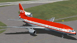
FSX native model, needs FSX ServicePack1 or 2 to run. Uses default panel and sound, no VC. FSX conversion of Erick Cantus beautiful FS9 WIP mesh. PSP repaint resource included.
By Thomas Ruth and Erick Cantu
| Filename: | LTU_Lockheed_L1011100.zip |
| License: | Freeware |
| Added: | 8th July 2011, 21:41:26 |
| Downloads: | 3,549 |
| Author: | Thomas Ruth, Erick Cantu |
| Size: | 9.63 MB |
| Category: Flight Simulator X - AFCAD Files | |
| Wide Sky Airpark Airport (JY31), NJ |
|
File Description:
Located 03 miles NW of Bridgeton, New Jersey on 23 acres of land, Wide Sky Airpark Airport is a private turf field 2550' in length. There is no fuel available, but there is tiedown space by the main hangar in the middle of the field to the west. You can start in the parking spot there if you have a plane with 40' or less wingspan (collision with static aircraft is disabled so you can put a bigger plane there if you wish with no trouble). The windsock is not lit at night and is located atop the south end of then main hangar's roof. The field is hedged in to the east with bushes but they do not cause aircraft collisions. The runway is lit for night VFR operations. There is no hard surfaced runway so set your terrain mesh settings as high as possible to enjoy rolling around on bare bumpy terrain.
Scenery constructed with use of satellite images/streetview/aerial photos - the author has not been there in person.
This scenery is meant to be used in conjunction with MegaScenery Earth New Jersey/Delaware 004. It is not required, but apron use is minimized to allow satellite scenery to show through as much as possible, and objects are placed based on the MSE textures - lack of it may make scenery look out of place.
| Filename: | Wide_Sky_Airpark_Airport_JY31_NJ.zip |
| License: | Freeware |
| Added: | 10th May 2011, 13:40:36 |
| Downloads: | 157 |
| Author: | Drew Sikora |
| Size: | 1.27 MB |
| Category: Flight Simulator 2004 - Scenery | |
| Alta circling approach |
|
File Description:
The old circling approach for runway 30 at Alta, Norway (ENAT) is a challenging approach. I don't think it is used anymore, but it was still in use during the 1980:s and perhaps even into the 1990:s when SAS flew DC-9 i northern Norway. During the approach you fly a circle, following lights in the terrain and keeping track of the altitude. Included in this zip-archive are the bgl-files for the lights and the old approach plates for Alta. Recommended additional installations are Norway airports and Norway Mesh.
Happy flying!
| Filename: | Alta_circling_approach.zip |
| License: | Freeware |
| Added: | 20th May 2010, 02:48:06 |
| Downloads: | 439 |
| Author: | Krister Renard |
| Size: | 328.64 KB |
| Category: Flight Simulator X - AFCAD Files | |
| KLEB - Lebanon Municipal Airport - Lebanon, NH |
|
File Description:
Here is an improved version of the stock Lebanon Municipal Airport. I adjusted taxiways and aprons per
Google Earth. I removed and replaced several buildings and added others. Removed the tower and added
a new one in a more proper location. Added static airplanes and helicopters, parking lots with cars and
light poles. Added the terminal and parking for Colgan Air and also GA parking on the NW ramp
| Filename: | KLEB__Lebanon_Municipal_Airport__Lebanon_NH.zip |
| License: | Freeware |
| Added: | 6th September 2008, 07:35:11 |
| Downloads: | 747 |
| Author: | Jim Cook |
| Size: | 8.75 KB |
| Category: Flight Simulator 2004 - Scenery | |
| Brevoort CWOB and BAF-3 radar plus Cartwright LAB-6 radar Canada |
|
Images related to this file:
File Description:
Brevoort airstrip and the BAF-3 radar it serves is on Brevoort Island, off one of the southeastern tips of Baffin Island and 140 miles east of Iqaluit. This scenery includes the BAF-3 buildings on the hilltop and those on the airstrip below, plus the roads connecting them and down to the beach landing area on the rocky coast. This scenery is made for the FSGenesis 76m terrain mesh for northern Canada, and there will be a repost of all my northern Canada airfields to suit this; I cannot think now why I never installed this mesh before. The AI reflects the use of civil airlines for resupply and transportation of personnel. Given the terrain the wind should be from the north so that ai lands using the 02 runway. Landing from the north will involve a terrain clash while take off towards the north will not as the climb out clears the hilltop. The video shows the 600 foot cliff at the runway threshold and an Air Tindi plane on the apron. Cartwright CYCA is on the Labrador coast and has been posted by Flight Ontario as part of their Goose Bay and Labrador Regional Airports sceneries. The nearby LAB-6 radar site is included here, connected to CYCA by an extended road. The site uses the same buildings as Brevoort and Saglek (posted recently) and although I have included them here as separate sceneries the contents can be placed in the same folders as Saglek with a saving in duplicated textures. The textures here are more accurate than Saglek so say yes to over-write; a downloader with personal experience of Brevoort noted that in reality they are lighter.
| Filename: | Brevoort_CWOB_and_BAF3_radar_plus_Cartwright_LAB6_.zip |
| License: | Freeware, limited distribution |
| Added: | 20th August 2017, 15:46:36 |
| Downloads: | 177 |
| Author: | Roger Wensley |
| Size: | 4.37 MB |
| Category: Flight Simulator X - Scenery | |
| Tonopah - KTPH |
|
File Description:
This file contains several BGL's which enhance the default FSX Tonopah, Nevada airport (KTPH).
Additional parking, scenery objects, and roads are added to the bland stock airport.
The "mesa" created by the stock airport backgound flatten is blended into the
surrounding terrain using "sloped flattens".
This scenery is not intended to re-create a perfect match to the real world but
to enhance the visual experience of flying into and out of the airport.
The files were tested with FSX-Acceleration\SP2 on WinXP Pro, DX9.
I used 10M mesh from the "FSX Usa 10 M terrains Project" when blending
the altitude data but the files should provide good results with the default FSX terrain.
| Filename: | Tonopah__KTPH.zip |
| License: | Freeware |
| Added: | 21st December 2007, 04:29:50 |
| Downloads: | 1,174 |
| Author: | Paul Strogen |
| Size: | 812.46 KB |
| Category: Flight Simulator 2004 - AI Aircraft | |
| Middle East Airlines Boeing 707-320B, circa 1974 |
|
File Description:
Middle East Airlines Boeing 707-320B, circa 1974 for AI traffic. A repaint of Dee Waldron's B707-320. Flightplans for MEA, 1974 available at RetroAI (see readme for link)
| Filename: | Middle_East_Airlines_Boeing_707320B_circa_1974.zip |
| License: | Freeware, limited distribution |
| Added: | 3rd July 2007, 01:34:38 |
| Downloads: | 411 |
| Author: | Christian Page |
| Size: | 243.61 KB |


© 2001-2026 AVSIM Online
All Rights Reserved
Privacy Policy |