
Where Flight Simulation Enthusiasts Gather from Around the World!
AVSIM Library - Search Results

| Category: Flight Simulator 2004 - Scenery | |
| Kotzebue PAOT on the northwestern coast of Alaska |

|
Images related to this file:
File Description:
There are four main northwestern Alaska towns which have good airports and are serviced by Alaska Airlines. From these airports local flights connect to nearby villages, "nearby" in Alaska meaning up to 150 miles away. The northernmost is Barrow. Southwest of Barrow is Kotzebue, then Nome, and the furthest south is Bethel. The town of Kotzbue is north of the Bering Strait on the northwestern coast, 320 miles southwest of Barrow. The population is just over 3,000 people. The location was for a long time a base for trading in furs, with three rivers emptying into the sea and providing routes into the interior land and villages; a meeting place between hunters and traders from Russia and elsewhere. The Kotzebue airport is called the Ralph Wien Memorial and has two runways. The modern one is aligned 08-26 and is 5,880 feet of 150 feet wide asphalt built across a shallow lagoon, with an ILS on 08 and PAPI on both ends. The second and older runway is originally military and gravel, aligned 17-35 and 3,786 feet long and used (wind allowing) by the GA planes that park alongside the runway. The prevalent wind is from the west; when the wind is from the east it is generally relatively feeble and with a much lower cloud base, possibly to the ground, hence the need for an ILS. All AI aircraft in FS9 much prefer to use a runway that has an ILS and so will continue to use 08-26 even if the wind is from the south until it reaches 30+ knots, even if they are a Cessna 150 flying VFR. So for AI realism in FS9 a northern or southern wind needs to be a strong one so that the runway is actually used. However, as Alaska Airlines, Northern Air Cargo, and Everts Air also fly to Kotzebue and can only use the east-west runway (as less than 4,000 feet of asphalt would be seriously inconvenient for a Boing 737 or DC6) it is necessary to have the northern or southern wind UNDER 30 knots at the times when they are landing or taking off. Your choice. I suppose a permanent strong wind from the west would be the most realistic on a daily basis, deterring all planes from ever using 17-35. The AI will develop along with further scenery additions in the neighbourhood.
| Filename: | Kotzebue_PAOT_on_the_northwestern_coast_of_Alaska.zip |
| License: | Freeware, limited distribution |
| Added: | 2nd August 2016, 16:47:52 |
| Downloads: | 463 |
| Author: | Roger Wensley |
| Size: | 19.32 MB |
| Category: Flight Simulator 2002 - Scenery | |
| Victorian Airfields - Australia |
|
File Description:
This add-on scenery pack for FS 2002 adds 115 airfields to Victoria plus a few to NSW and South Australia,
totalling to over 120 in all. The 36 airfields listed below include full detail including accurately placed and sized
trees and buildings, static aircraft, fences, cars, roads with cars and streetlights and a variety of other
'eye candy'. The remaining airfields are mostly small minor/private strips and all include runway markers and
a windsock but you'll find a few buildings and other scenery at some of them. Rotorheads will also enjoy flying to the 10 included helipads scattered across the area around Melbourne. This scenery is a 'must have' for anyone who enjoys flying 'Downunder'!
The Following airfields are included in this package in full detail:
LILYDALE, COLDSTREAM, TOORADIN, PAKENHAM, TYABB, SUNBURY , WALLAN, MELTON, BACCHUS MARSH, GEELONG, TORQUAY, CORIO, BARWON HEADS, PORT FAIRY, LAKES ENTRANCE, APOLLO BAY, KYNETON, PHILIP ISLAND, LOCKSLEY, LETHBRIDGE, CERES, BENDIGO GLIDING CLUB, GRAMPIANS AIRFIELD, MILAWA, WENTWORTH, YARRAM, ORBOST, MALLACOOTA, MT BEAUTY, MOONGARA, WERRIBEE AIRSTRIP, BOORT, COBDEN, MEREDITH, WOODVALE, RIDDELLS CREEK
Using this scenery pack will make your flights around these airfields so much more exciting and enjoyable. No more boring old
unpopulated terrain around Victoria, you've got 115 new airfields available to fly from!
| Filename: | Victorian_Airfields__Australia.zip |
| License: | Freeware |
| Added: | 15th August 2003, 19:47:02 |
| Downloads: | 807 |
| Author: | Sebastian Szalai |
| Size: | 10.53 MB |
| Category: Flight Simulator 2004 - Aircraft Repaints, Textures and Modifications | |
| XL Airways Germany (Excel Airways Germany) Airbus A320 IAE |
|
File Description:
This is a DXT3 photoreal repaint of the Wilco A320 IAE Airbus that comes with the payware Wilco Airbus collection, Vol 1, Deluxe Edition.This repaint is based on the real life A320 IAE XL Airways Germany, registration number D-AXLA. Just XL Airways Germany and France still operating. Wilco Feelthere Vol 1, Deluxe Edition 320 IAE is necessary to use this Repaint. Livery works with FS9. FSX are not tested. Hope you enjoy my first repaint contribution! Comments are welcome.
****NOTE:
XL-Airways-Germany and exactly the rePaint I made (D-AXLA), never existed in real-life.
This Aircraft crashed on 27.Nov.08 on a post-maintenance test flight into the Mediterranean Sea east of the French city of Perpignan, The aircraft was leased to XL Airways Germany by Air New Zealand, and had been repainted with Air New Zealand's livery in preparation for its return to Air New Zealand the following week.
I will be creating a new repaint for this aircraft in the future.****
| Filename: | XL_Airways_Germany_Excel_Airways_Germany__Airbus_A.zip |
| License: | Freeware |
| Added: | 8th November 2008, 19:02:08 |
| Downloads: | 814 |
| Author: | Max Flechsig |
| Size: | 7.33 MB |
| Category: Flight Simulator 2004 - Utilities | |
| Servinfo Update 05-04-10 |
|
File Description:
Thank you for downloading this 4th update of Servinfo 2.02.
This update actualised with logos and data:
AEROCONDOR,AerovÃ�ÂÂas C�³ndor De Colombia(revised),AerolÃ�ÂÂnea Virtual del Caribe,Aeropostal(revised),Aerosur(Bolivia),Air Armenia,Air Florida(Palm)Air Greece,AirNova(Revised),Air Panama,Air Senegal International,Air Wisconsin(revised and logo)Aviaci�³n Naval De Chile,Aviateca,Azerbaijan Airlines,Canadian Xpress,Egyptair Cargo
EuflyVirtual,Freight Dogs,Fuerza A�©rea Mexicana,Isle�±a,Jet Fighter Flights,JetWay Brasil,LÃ�ÂÂneas A�©reas Paraguayas,Malm�¶ Aviation,MAT Macedonian Airlines,MIAT Mongolian Airlines,Midway Airlines(Logo),Montenegro Airlines,Nigerian Air Force,Portuguese Navy
Republic of Singapore Air Force,Royal Malaysian Air Force,Royal New Zealand Air Force, Royal Saudi Air Force,Sansa Regional,Seagle Air,South East Asian Airlines,South Pacific Island Airways,Sudan Airways,Surinam Airways,Swiss Air-Ambulance(REGA),Titan Airways,Ukraine International Airlines and Westport Virtual Charters.
| Filename: | Servinfo_Update_050410.zip |
| License: | Freeware |
| Added: | 5th April 2010, 20:56:15 |
| Downloads: | 485 |
| Author: | Daniel Nole |
| Size: | 1.4 MB |
| Category: Flight Simulator X - Scenery | |
| Dieuze - Gueblange V2 |
|
Images related to this file:
File Description:
This scenery depicts Dieuze-Gueblange aerodrome located in the north east of France. It is a very accurate rendition of this aerodrome made with photoreal textures for the ground and the objects. The ground is covered with volumetric grass. I have modelled an animated sock that indicates the wind direction and velocity. To see this windsock, Sode (Sim Objects Display Engine) module must be installed (module availabale here : http://sode.12bpilot.ch/?page_id=9). A user manual (pdf) is included.
The windsock library may be used in your own sceneries. If you share a scenery using this library, you must add the BJP_SOCKS folder without any modification in order to avoid duplicate files. Please include my name in any of your included documents. This new release is now compatible with a landclass environment: snowy ground and trees in the hard winter (from the first day of december to the last day of january). Please read the specific enclosed manual.
| Filename: | Dieuze__Gueblange_V2.zip |
| License: | Freeware, limited distribution |
| Added: | 1st February 2015, 23:14:45 |
| Downloads: | 1,453 |
| Author: | Jacques-Paul Bollard |
| Size: | 21.98 MB |
| Category: Flight Simulator X - Aircraft Repaints, Textures and Modifications | |
| Cathay Pacific "60s Era Jet" DC6A |
|
Images related to this file:
File Description:
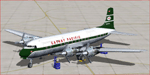
She's a "Cathay Pacific", DC6A Combi Passenger, Large Spinners. The Livery is a Fantasy 1960's Era, and Depicts CPA's DC6. During My Time in the Far East, in the Mid 60's, We saw Many Cathay Pacific Jets in a Gorgeous Livery. At one time Cathay did Fly DC6's, in the 50's.I have down loaded a Repaint of a 50's CPA DC6, which is Very Nice. What would this Airplane Look like in a Jet Job Mid 60's Livery, the Result, REALLY Elegant. Try it ON and let Me know what You Think ?? Hope You Enjoy this Repaint as much as I have Enjoyed Creating it!!
For Tom Gibson's FSX/FS2004 DC6A Combi Spinner. For FSX, FSX SE, P3d V1.4. This file is Textures Only. The original aircraft is available at http://www.calclassic.com/ You MUST download and install DC-6A CB-17 Base Pack from http://www.calclassic.com/.
| Filename: | Cathay_Pacific_60s_Era_Jet_DC6A.zip |
| License: | Freeware |
| Added: | 5th May 2016, 07:43:13 |
| Downloads: | 202 |
| Author: | John Henkel |
| Size: | 7.23 MB |
| Category: Flight Simulator 2004 - Scenery | |
| CYHD - Dryden Regional - Ontario, Canada * Updated v2 * |
|
Images related to this file:
File Description:
This greatly modifies my previous (2009) post of Dryden; this version has bespoke buildings and is stand-alone and does not require you to have the previous post. There will also be follow-up posts of Sioux Lookout and Geraldton. Dryden is in northern Ontario, 110 miles east of the Manitoba border, 40 miles west of Sioux Lookout, and with the US border 90 miles to the south. The town is on the northern shore of Wabigoon Lake and has a population of around 7,800. The main business is pulp and paper, along with agriculture, tourism, and mining. The airport is 5 miles northeast of the town.
Dryden Regional has 6,000' of asphalt which in FS9 is aligned 11-29. The second runway is compacted sand 2,000' long and aligned 05-23. There are two aprons, the western being for the terminal building and some ga parking, and the eastern larger and used in the summer for parking fire fighting planes, along with maintenance hangarage and accomodation etc. The Ontario Fire Service planes were included with my original Geraldton post and are included here again; they fly back and forth and keep Dryden busy along with several Bearskin Airlines and Perimeter Aviation flights.
| Filename: | CYHD__Dryden_Regional__Ontario_Canada___Updated_v2.zip |
| License: | Freeware, limited distribution |
| Added: | 16th March 2013, 09:59:52 |
| Downloads: | 595 |
| Author: | Roger Wensley |
| Size: | 26.99 MB |
| Category: Flight Simulator 2004 - Miscellaneous Files | |
| Nick's Prop Dust with Control Gauges |
|
File Description:
Prop aircraft users are in for a real treat. This gauge/effects package automatically senses the terrain the aircraft is in contact with or flying over and changes the dust and water effects for the aircrafts prop/rotor wash based on dirt, dry mud or clay, snow, rain, water, ice, sand, gravel and short grass. In addition the real time surface conditions are also sensed. In example, a dry asphalt or concrete runway will produce no dust, however, the same runway with snow conditions present will automatically produce a throttle controlled snow blowing effect. The 25 included effects files and 5 gauges have been tuned to reflect a realistic representation of the dust/mist produced by different types of aircraft taking off or touching down on different terrains and surface conditions. The effects are properly influenced by cross wind conditions and reverse pitch is also supported. Effects files and gauges are included for large and small, single engine, multi-engine, amphibians, helicopters and massive scale military and commercial transports. It requires editing/adding lines in the aircraft.cfg and panel.cfg files. The README files include very complete and comprehensive instructions including a quick and easy copy/paste file for all the Microsoft prop aircraft and tutorial on making custom gauges from the ones provided.
By Nick Needham
| Filename: | Nicks_Prop_Dust_with_Control_Gauges.zip |
| License: | Freeware |
| Added: | 8th December 2003, 17:07:07 |
| Downloads: | 7,298 |
| Author: | Nick Needham |
| Size: | 1.22 MB |
| Category: Flight Simulator 2004 - Scenery | |
| Hicks Farm Field CF12 near Ottawa in Ontario, Canada |
|
Images related to this file:
File Description:
Hicks Farm is in Ontario and around 8 miles west of Rideau Valley Airpark CPL3 (which did not appear in FS9, probably because it was then mainly used by gliders, but is a post of mine). CPL3 is 15 miles south of Ottawa Airport, tucked into a right angle bend of the Rideau River. Ultimate Terrain puts the river into place, and I am not sure of how or if either CPL3 or CF12 work without UT, maybe somebody can let me know. Fly west from CPL3 along the river and Hicks Farm will be on the south side. It has a (mainly) grass runway 34/16 with a section of asphalt and totals some 5,500 feet overall. Alan, the owner of Hicks Farm, is in his mid 80's and was told last year that his insurance company no longer felt comfortable with him flying his Lear off a farm strip. The result of his enforced retirement from flying his Lear is that the grass has been allowed to take over somewhat, though there is still sufficient space to land most single engine light aircraft.
| Filename: | Hicks_Farm_Field_CF12_near_Ottawa_in_Ontario_Canad.zip |
| License: | Freeware, limited distribution |
| Added: | 11th February 2010, 00:50:23 |
| Downloads: | 271 |
| Author: | Roger Wensley |
| Size: | 1.43 MB |
| Category: Flight Simulator 2004 - Scenery | |
| PAAQ - Palmer Muni - Anchorage, Alaska - USA |
|
Images related to this file:
File Description:
Palmer PAAQ is in Alaska, some 40 miles northeast of Anchorage on the north side of Knik Arm and beside the west bank of the Matanuska River. It is for both GA and commercial aircraft. There are two apron areas, north and south, separated by the east-west runway. The north apron is for the Forestry Service planes and for resident GA tie-down places and hangars, along with maintenance facilities; the southern end of the north apron is for itinerant aircraft. The south apron is almost entirely for commercial companies and again maintenance. The main runway is just under 6,000 feet long, aligned L16-R34 and asphalted and lit, as is the parallel taxiway A. There is also a shorter and parallel runway that is grass and which receives no winter maintenance. The second main runway is 3,600 feet long and aligned 09-27, asphalt and lit and with a parallel taxiway B, also lit. The airport is undergoing a process of upgrading, which explains the varied colours (and age) of resurfaced taxiways. There are adjustment bgl's for two other neighbourhood airstrips, Toad Lake 24AK and Wolf Track 9AK8, which I just discovered buried in nearby holes in the ground; I also revised their runway surfaces.
| Filename: | PAAQ__Palmer_Muni__Anchorage_Alaska__USA.zip |
| License: | Freeware, limited distribution |
| Added: | 4th November 2014, 00:01:43 |
| Downloads: | 448 |
| Author: | Roger Wensley |
| Size: | 22.35 MB |


© 2001-2026 AVSIM Online
All Rights Reserved
Privacy Policy |