
Where Flight Simulation Enthusiasts Gather from Around the World!
AVSIM Library - Search Results

| Category: Flight Simulator 2004 - Scenery | |
| High Prairie CZHP in Alberta, Canada |

|
Images related to this file:
File Description:
High Prairie is at 1,974 feet asl, 15 miles west of Lesser Slave Lake, 70 miles southeast of Peace River CYPE, and 90 miles east of Grande Prairie CYQU (both already posted). The town has a population of around 2,600 and is based on agriculture, forestry, and oil and gas. The initial impetus behind its growth was the routing of the railroad in 1914. The airport is around 2 miles south of the town, and is fairly basic. There is a single runway just under 4,000 feet of asphalt aligned 07-25. There is a daily flight and around 2010 this was by Central Mountain Air. I believe that there is now a newer terminal building, but a lack of information leaves the older one in place here. There are runway and taxiway lights, unlike some of my recent posts. I made this to fill in the gap between Edmonton and the airports to the northwest such as Grande Prairie.
| Filename: | High_Prairie_CZHP_in_Alberta_Canada.zip |
| License: | Freeware, limited distribution |
| Added: | 9th December 2018, 17:21:09 |
| Downloads: | 123 |
| Author: | Roger Wensley |
| Size: | 3.16 MB |
| Category: Flight Simulator 2004 - Scenery | |
| Dawson Creek CYDQ in British Columbia, Canada |
|
Images related to this file:
File Description:
Dawson Creek is at 2,148 feet asl just east of the Rocky Mountains, less than 10 miles west of the BC/Alberta border. The Peace River, 25 miles north of Dawson Creek, links the two sides of the Rockies, winding through peaks that reach up almost to 8,000 feet. The population grew when the Northern Alberta Railway was extended to Dawsons Creek in 1932, and grew even more more when the Alaska Highway was built in 1942 and Dawsons Creek was where it started from. The airport is just to the east of the town. The runway is 5,000 feet of wide asphalt (150 feet) aligned 06/24, lit, and with PAPI and approach lights. There is a water runway to the north of the main runway with the same alignment, separately designated as Dawson Creek CBD3. The two operate as one; traffic for both use the mandatory frequency of 122.2 and talk to one controller in one control tower. However, in FS9 the ATC for two separately designated airfields operates as if they are nowhere near each other and near misses are the result. I have put them both in un-manned tower mode so you will announce your position and intentions and select your own parking spots etc. There is in reality a lack of apron markings but I have marked the positions of both gates. The apron is not large so there is only one other apron parking spot (see the traffic cone) and most parking is either next to one of the hangars or on the grass. The aprons vary from asphalt, to concrete, onwards to gravel, and then further onwards to some gravel amid the bare dirt; I have replicated this variation as far as FS9 permits. The buildings are bespoke from photos. The AI includes Central Mountain Air with two daily scheduled flights and Northern Cariboo as one of the airlines that occasionally runs charter flights in CYDQ. There are also private GA flights, and float plane flights into and out of CBD3.
| Filename: | Dawson_Creek_CYDQ_in_British_Columbia_Canada.zip |
| License: | Freeware, limited distribution |
| Added: | 22nd November 2013, 23:31:40 |
| Downloads: | 655 |
| Author: | Roger Wensley |
| Size: | 16.65 MB |
| Category: Prepar3D V1-4 - Aircraft Repaints, Textures and Modifications | |
| North American P-51D (H-330) RNEIAF |
|
Images related to this file:
File Description:
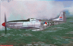
This folder contains a repaint for the A2A WoP3 P-51D Mustang (with AccuSim), in the colors of P-51D-25-NT 44-84793 'Evelyn' in the new colors of H-330 of the red patrol, 120 squadron, Dutch East Indies Air Force, based in Andir, 1948. The '330' on the nose was a remnant of the earlier paintscheme this aircraft carried, with flags instead of roundels. The aircraft later passed on into the Indonesian Air Force (AURI) where it flew as F-330. Repaint by Jan Kees Blom, based on the A2A paintkit.
| Filename: | North_American_P51D_H330_RNEIAF.zip |
| License: | Freeware |
| Added: | 30th October 2018, 15:24:36 |
| Downloads: | 68 |
| Author: | Jan Kees Blom |
| Size: | 13.22 MB |
| Category: Flight Simulator 2004 - AI Aircraft | |
| US General Aviation AI Pack 3 |
|
Images related to this file:
File Description:

AI for FS2004 in the US north-east area, using single-engined Cessna models which are part of the Cessna singles payware package, by Henry Tomkiewicz, available from www.htaimodels.com. These 37 paints are of aircraft residing, at last information, from New England down to Delaware, with some in adjoining states. The included flightplans have them crossing those states regularly, as well as visiting airfields from North Carolina to just across the Canadian border.
Some sceneries by John B. Loney Jr. enclosed (with his permission). Download of three further sceneries recommended but not mandatory (see documentation).
| Filename: | US_General_Aviation_AI_Pack_3.zip |
| License: | Freeware, limited distribution |
| Added: | 26th October 2014, 11:25:17 |
| Downloads: | 856 |
| Author: | John Burford and John B. Loney Jr. |
| Size: | 10.23 MB |
| Category: Flight Simulator 2004 - Scenery | |
| KSGU-Saint George, Utah |
|
File Description:
The 6600' long St. George airport in southwestern Utah sits high on a mesa! You grasp your armrest hoping that you will become airborne before you fall off the cliff...Or just after landing you are nervously waiting for the pilot to apply the brakes as the end of the runway rushes up to meet you before you fall into nothingness! Such is the fate that awaits the pilot or passenger that ventures to the Saint George, Utah airport.
Actually, it is a very safe and delightful airport to base your flights from. Visit Southern Utah and see the many sights that await the adventurous soul. Take a trip from KSGU to Moab-KCNY or KVEL and marvel at the diversity of the landscape. ( I upgraded those 2 airports also.)
While designed for use with Ultimate Terrain, this enhancement should work with the default FS2004 setting. Please unzip to a temporary folder and follow the simple installation instructions.
| Filename: | KSGUSaint_George_Utah.zip |
| License: | Freeware |
| Added: | 23rd August 2008, 09:49:58 |
| Downloads: | 1,412 |
| Author: | Alan C. Heiner |
| Size: | 664.81 KB |
| Category: Flight Simulator 2004 - Scenery | |
| Hawk Logging, for Holger Sandmann's scenery |
|
Images related to this file:
File Description:
This is a logging camp, on Admiral Island at the northern end of Chatham Strait in southern Alaska, around 30 miles south of Juneau. It is marked on the chart of the area; if you are chartless then there is a section of the chart included here. This scenery is designed specifically for use in the Tongass Fjord scenery (or Glacier, or Misty? I don't remember now which area it is in!) and probably does not work with just Ultimate Terrain; I haven't tried it. The camp has an identifying code so it will show up on a gps as PELC but there is no interaction with atc as there are no designated water runways; PELC on the GPS just acts as a waypoint. There will be further posts for use with Tongass Fjords, Misty Fjords, and Glacier Bay, and I still find these scenery areas by Holger and his crew the most satisfying in FS9.
| Filename: | Hawk_Logging_for_Holger_Sandmanns_scenery.zip |
| License: | Freeware, limited distribution |
| Added: | 8th November 2014, 22:42:24 |
| Downloads: | 319 |
| Author: | Roger Wensley |
| Size: | 12.37 MB |
| Category: Flight Simulator 2002 - Scenery | |
| The Bolzano Challenge |
|
File Description:
Bolzano LIPB scenery for FS2002. Bolzano airport is situated in the Dolomiti Alps of North Italy surrounded by steep rising hills. The dangerous approach for this airport is one of Europe's hardest. In the color IFR charts included you will find what it takes to do the standard landing approach for rwy 01, the standard missed approach and the standard istrument departure. In real, only authorised pilots by Italy CAA are allowed to fly this demanding approach. The approach is an offset LOCDME, with a track that maintains terrain clearance, requiring you to fly a steep descent of 5 degrees where there is no glideslope guidance. When I saw that this amazing airport is FS2002 has only a runway and tower, I decided to create this addon which is a simple enhancing scenery for an airport left out empty by MS. The scenery includes, lighted taxiways, aprons, lighted terminal and hangars, perimeter fence, extra trees and correct approach lighting. ASD Textures included.
| Filename: | The_Bolzano_Challenge.zip |
| License: | Freeware |
| Added: | 28th November 2002, 03:13:52 |
| Downloads: | 4,741 |
| Author: | Kyprianos Biris |
| Size: | 1.71 MB |
| Category: Flight Simulator 2004 - Scenery | |
| Pete & Sid's Viva Scenery Volume 4 |
|
File Description:
This is a collection of scenery enhancements for 81 airports, mostly smaller ones, located primarily in the Pacific Northwest, Alaska and Western Canada. (Yes, there's one in New Zealand.) It was not our intention to do anything fancy or particularly accurate, but simply to make the default scenery less boring and more fun. General aviation AI traffic (using default FS9 aircraft) is also included for some of these airports. The scenery for any individual airport may be removed without affecting the other airports. Some the airports we've done may also be included in Glacier Bay and other scenery add-ons; you'll need to remove one or the other to resolve any conflicts. This scenery was designed to work with Flight1's Ultimate Terrain and has not been tested with the default FS9 scenery. Most of the airports will probably work fine with the default scenery; those airports near water features (lakes, rivers, coastlines) are the ones most likely to have problems.
| Filename: | Pete__Sids_Viva_Scenery_Volume_4.zip |
| License: | Freeware |
| Added: | 12th July 2008, 13:22:06 |
| Downloads: | 2,258 |
| Author: | Sidney Schwartz & Peter Ham |
| Size: | 1.03 MB |
| Category: Flight Simulator 2004 - Scenery | |
| Beaver Creek CYXQ 1.1 |
|
Images related to this file:
File Description:
Version 1.1 adds the missing door on the ground side of the terminal building. It is complete and does not require that you already have the previous version.
Beaver Creek CYXQ is a small airport in the northern Canada Yukon Territory, near the Alaskan border. There is a customs facility located on the Alaska Highway adjacent to the airport. There is an NDB located on the field, but no published instrument approaches. The single gravel runway is 3740'long.
This scenery was completely redone and features a custom photoreal terminal and custom runway/taxiway lights. The adjacent customs facility is included but is not based on the real one as I had no photos to work from. The custom runway lights are always on, even during the day...sorry, this is an FS9 limitation.
This scenery was designed for use with Ultimate Terrain and was not tested in the default scenery. It may or may not work in FSX.
| Filename: | Beaver_Creek_CYXQ_11.zip |
| License: | Freeware |
| Added: | 6th November 2010, 22:31:24 |
| Downloads: | 916 |
| Author: | Sidney Schwartz & Peter Ham |
| Size: | 447.05 KB |
| Category: Flight Simulator 2004 - Scenery | |
| Iloilo Airport ,Iloilo City, Philippines |
|
File Description:
Iloilo Airport is located in Iloilo City, Panay Island, Philippines. This local visayan airport is served by the following major domestic airlines: Philippine Airlines, Cebu Pacific and Air Philippines. This scenery features the most realistic replica of buildings located in the airport area such as the Main Terminal buildings, Control Tower, Crash and Fire Rescue Station, Philippine Air Force building, private hangars, shops, and commercial buildings including the SM City-Iloilo right in front of the airport area. SM City's parking area is generally filled with vehicles everyday that they are very visible at the ramp area of the airport at daytime and most especially visible glittering at nighttime.
This scenery also features the different commercial vessels serving Iloilo City such as WG&A Superferry, Sulpicio Lines, Negros Navigation, and Philippine Fastferry Corporation's Supercat and SeaAngels. These vessels are visible when flying from Iloilo to Bacolod City passing through the Guimaras Channel.
This scenery is designed with the combined efforts of Ver Walter Gulfan of Cebu City, Philippines and Manny Aquino of Surabaya, Indonesia. For suggestions or comments, please visit our Philippine Flightsimmers Group website at www.philskies.net or you may join our forum at www.philskies.net/forum.
RPVI AFCAD file included with aircrafts taking off at the middle of the runway!
| Filename: | Iloilo_Airport_Iloilo_City_Philippines.zip |
| License: | Freeware |
| Added: | 29th August 2003, 21:38:49 |
| Downloads: | 5,814 |
| Author: | Ver Walter Gulfan/Manny Aquino,Jr. |
| Size: | 5.83 MB |


© 2001-2026 AVSIM Online
All Rights Reserved
Privacy Policy |