
Where Flight Simulation Enthusiasts Gather from Around the World!
AVSIM Library - Search Results

| Category: Flight Simulator X - Scenery | |
| NRAO - Karl G. Jansky Very Large Array |

|
Images related to this file:
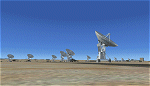
File Description: The VLA or "Jansky Array", managed by the National Radio Astronomy
Observatory (NRAO) consists of 27 independent radio telescope dishes, each with
a diameter of 82 feet and weight of over 200 tons. Each antenna is found along
the three arms of a track shaped in a Y configuration measuring 13 miles long.
Using the rail tracks that follow each of these arms the antennas can be
physically relocated to a number of prepared positions. At one point, the arms
intersect with U.S. Route 60 which passes right through the middle of the array.
It has been featured in numerous films, such as Armageddon, Independence Day,
Terminator Salvation, a Bon Jovi music video, and was featured most prominently
-and correctly- in the Carl Sagan novel Contact, as well as the film of the same
name. Also updated is the closest airport to the VLA - Magdalena, NM - N29. It's
a small dirt strip a few miles to the east, between Socorro and the VLA. It
serves as a nice staging area for flights to the VLA. Includes a helipad startup
location with NM99 ident. Scenery by Jason L. Terry. For FSX Acceleration.
| Filename: | NRAO__Karl_G_Jansky_Very_Large_Array.zip |
| License: | Freeware |
| Added: | 23rd August 2014, 11:18:02 |
| Downloads: | 409 |
| Author: | Jason L. Terry |
| Size: | 3.18 MB |
| Category: Flight Simulator X - Scenery | |
| RAF Molesworth |
|
File Description:
At the start of World War II the Air Ministry selected the area as the site for what would become RAF Molesworth. The base was built in 1940 and 1941. The first unit, Royal Australian Air Force 460 Squadron was formed at the base on November 15, 1941 with Vickers Wellington IVs. 460 Squadron departed the field on January 4, 1942. RAF Bomber Command 159 squadron moved in shortly afterwards, however this unit did not remain long, moving to the Middle East on January 12.
Molesworth was one of the early Eighth Air Force stations assigned to the United States Army Air Force (USAAF). In February 1942, General Ira Eaker and four US staff members inspected Molesworth for possible American use, and during 1942 the facility was improved to Class A airfield standard, with all of its runways extended to American specifications for heavy 4-engined bombers. The main runway was lengthened to 2,000 yards and the number of hardstands increased to fifty. It was given USAAF designation as Station 107.
From 16 September 1943 – 18 June 1945, Molesworth served as headquarters for the 41st Combat Bombardment Wing of the 1st Bomb Division.
| Filename: | RAF_Molesworth.zip |
| License: | Freeware |
| Added: | 17th January 2009, 14:00:45 |
| Downloads: | 552 |
| Author: | Scott Berge |
| Size: | 22.77 KB |
| Category: Flight Simulator X - AFCAD Files | |
| PAKT - Ketchikan airport - Ketchikan, Alaska - USA |
|
Images related to this file:
File Description:
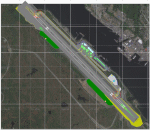
This AFCAD requires payware "Ultimate Terrain Alaska X"!! It will not work without it as it is built on the underlying terrain features and the included file "PAKT_AP.BGL" which has to be renamed or moved to a folder outside the FSX terrain environment. The original file included some errors which I tried to correct. This patch is published with permission.
Changes: The apron layout is corrected including now taxiway "C" leading to GA parking. The pavement has been changed to asphalt as it appears to be when taking aerial pictures as template. The runway got the proper overruns at both sides and the position of the ILS glideslope and localizer has been corrected as well as the DME. The layout of the airport building arrangement including the tower should be now closer to the real world and I added a working jetway. However, I used FSX default objects. As I was dependent on quite rare layout information I just tried to adjust the taxi paths and parking spots probably closer to the reality than before but I did not put any effort to name the parking spots like in real life nor did I take care for taxi signs (only the runway entries got such).
| Filename: | PAKT__Ketchikan_airport__Ketchikan_Alaska__USA.zip |
| License: | Check within download |
| Added: | 25th May 2013, 19:40:38 |
| Downloads: | 442 |
| Author: | Axel Birsul |
| Size: | 1.28 MB |
| Category: Flight Simulator X - Gauges | |
| SimRate Gauge |
|
Images related to this file:
File Description:

SimRate Gauge displays and controls the simulation rate. Does your flight include a long-distance leg over boring terrain or water? Simply click on the gauge to cover the distance in a fraction of the time. It can be used as a popup or it can be added to an existing instrument panel.
| Filename: | SimRate_Gauge.zip |
| License: | Freeware |
| Added: | 12th February 2013, 06:38:21 |
| Downloads: | 491 |
| Author: | Rick Federmann |
| Size: | 19.76 KB |
| Category: Flight Simulator X - Scenery | |
| Coro Airport (SVCR) - Venezuela |
|
Images related to this file:
File Description:
National airport located in the city of Coro, capital of Falcon state,
in western Venezuela.
With photo-terrain scenery from satellite imagery in Google Earth.
Not compatible with versions prior to FSX.
This scenery includes terminal building and hangars with realistic
textures from images obtained from Internet.
Also includes a friendly Auto-Install.
| Filename: | Coro_Airport_SVCR__Venezuela.zip |
| License: | Freeware |
| Added: | 8th August 2011, 21:56:00 |
| Downloads: | 734 |
| Author: | David Maldonado |
| Size: | 39.83 MB |
| Category: Flight Simulator 2004 - Scenery | |
| Scenery Enhancements for the Innsbruck (LOWI), Austria |
|
File Description:
New roads, railroads, streams, river, landclass, and waterclass for the Innsbruck area, Austrian Alps. Based on 30-m and 10-m satellite imagery. Not a finished product but rather a "Sunday afternoon" project :-) to illustrate the visual improvements that can be achieved with a few hours of time commitment and the help of the wonderful Ground2K4 by Christian Fumey. The scenery looks best with one of the SRTM-based add-on meshes. I have included my Ground2K4 source code so that interested users can improve on and expand the project area (requires a separate download of my pre-processed satellite imagery).
| Filename: | Scenery_Enhancements_for_the_Innsbruck_LOWI_Austri.zip |
| License: | Freeware, limited distribution |
| Added: | 1st March 2004, 14:17:27 |
| Downloads: | 21,781 |
| Author: | Holger Sandmann |
| Size: | 1.3 MB |
| Category: Flight Simulator X - Scenery | |
| Elbtunnel |
|
Images related to this file:
File Description:
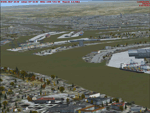
Correction of FSX default scenery.
There is no bridge across the river
Elbe east of EDHI but a 8-lane and
426,5 Meter long tunnel,the new (1975)
"Elbtunnel" as part of the Autobahn A7
from the Danish border to Fuessen/S-Germany
| Filename: | Elbtunnel.zip |
| License: | Freeware |
| Added: | 16th May 2010, 23:37:07 |
| Downloads: | 863 |
| Author: | Uwe Schweitzer |
| Size: | 147.74 KB |
| Category: Flight Simulator 2002 - Aircraft Repaints, Textures and Modifications | |
| Tanzania DHC-6 Twin Otter Air |
|
File Description:
This Aircraft was formerly used for domestic
Flights within Tanzania (East Africa).
Registration: 5H-MRB "Manyara". Repaint by
Jan Neuvians. Original model was designed
by Project Globe Twotter, G-Max model:
Udo Lemmob, Original Airfile: Barry
Blaisdell and Master texture: Samy Fay
| Filename: | Tanzania__DHC6_Twin_Otter_Air.zip |
| License: | Freeware |
| Added: | 24th June 2003, 21:14:54 |
| Downloads: | 360 |
| Author: | Jan Neuvians |
| Size: | 1.79 MB |
| Category: Flight Simulator 2004 - Scenery | |
| St.Mathias Airfield - Québec Short Hops |
|
File Description:
St.Mathias, part of Québec Short Hops is situated about 20 nm East of Montréal Int'l (Dorval) Airport, just a bicycle ride from my Richelieu Airfield scenery. Pullout facilities and crop dusting base operation. Sounds included for those who have the Lago program.
| Filename: | StMathias_Airfield__Qubec_Short_Hops.zip |
| License: | Freeware |
| Added: | 8th June 2004, 23:49:41 |
| Downloads: | 1,967 |
| Author: | Leon Louis |
| Size: | 3.1 MB |
| Category: Flight Simulator 2002 - Scenery | |
| Mollis (LSMF) Suisse 2002 |
|
File Description:
4th Swiss airport - Mollis is a old military airport East of Switzerland. It's now also a GA airport with a special approach due to the moutains arround. Includes smoke effects, seasonal change, photorealistic texture. Must have CH03-tx1.zip and CH03-tx2.zip.
| Filename: | Mollis_LSMF_Suisse_2002.zip |
| License: | Freeware |
| Added: | 4th January 2003, 14:06:23 |
| Downloads: | 2,404 |
| Author: | Daniel Gauthier |
| Size: | 2.28 MB |


© 2001-2026 AVSIM Online
All Rights Reserved
Privacy Policy |