
Where Flight Simulation Enthusiasts Gather from Around the World!
AVSIM Library - Search Results

| Category: Flight Simulator 2004 - Scenery | |
| Turkey Mesh SRTM V2, Part I |

|
Images related to this file:
File Description:

SRTM Version 2 is the result of a substantial editing effort by the National Geospatial Intelligence Agency and exhibits well-defined water bodies and coastlines and the absence of spikes and wells.
| Filename: | Turkey_Mesh_SRTM_V2_Part_I.zip |
| License: | Freeware |
| Added: | 25th January 2011, 14:32:24 |
| Downloads: | 3,444 |
| Author: | Tuncer Celik |
| Size: | 88.4 MB |
| Category: Flight Simulator 2004 - Scenery | |
| Karipur VOCL |
|
Images related to this file:
File Description:
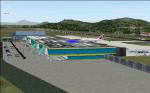
Karipur-VOCL for FS2004.
This contains the Airport of Calicut, Kerala, India
Karipur is a new International airport in Kozhikode or Calicut.
It handles planes to Middle East and Domestic.
This file contains the real airport.
Requeres South India Mesh and EZ library for small objects
to show up.
Terminal made in gmax and small objects added with EZ.
| Filename: | Karipur_VOCL.zip |
| License: | Freeware, limited distribution |
| Added: | 1st October 2010, 17:44:35 |
| Downloads: | 1,161 |
| Author: | Anstin Antony |
| Size: | 2.21 MB |
| Category: Flight Simulator 2004 - Scenery | |
| KPDX Plateau Flatten |
|
File Description:
This small file will improve the elevation problem between the Columbia River and KPDX for users of FSGenesis 38m mesh and Ultimate Terrain USA.
| Filename: | KPDX_Plateau_Flatten.zip |
| License: | Freeware, limited distribution |
| Added: | 2nd September 2005, 08:17:10 |
| Downloads: | 1,407 |
| Author: | Dan Reynolds |
| Size: | 1.21 KB |
| Category: Flight Simulator 2004 - Scenery | |
| Landscape Enhancements for Ultimate Terrain Canada/Alaska |
|
File Description:
This is a re-issue of my previously published landscape enhancement packages for parts of Southeast Alaska, British Columbia, Alberta, and Washington State. These files have been edited and adjusted to be fully compatible with FlightOne's "Ultimate Terrain: Canada/Alaska" product. Also, I have adjusted some of Ultimate Terrain's lake and river elevations to better fit new third-party add-on mesh files, such as the "Cordillera" mesh by FS Genesis and my freeware mesh files made for the individual coverage areas. Please note: A registered copy of "Ultimate Terrain: Canada/Alaska is required!!!
| Filename: | Landscape_Enhancements_for_Ultimate_Terrain_Canada.zip |
| License: | Freeware, limited distribution |
| Added: | 8th June 2005, 03:47:26 |
| Downloads: | 7,333 |
| Author: | Holger Sandmann |
| Size: | 3.44 MB |
| Category: Flight Simulator 2004 - Scenery | |
| Scenery Fuerstenfeldbruck - Airbase ETSF (Germany) |
|
File Description:
Airbase ETSF "Fürsty" in southern Germany, now also used by sport aviators.
Some AI-Traffic included. Compatible with Burkhard Renks "Landclass Germany" and Werner Vogts "SRTM scenery mesh". Only tested in FS2004.
| Filename: | Scenery_Fuerstenfeldbruck__Airbase_ETSF_Germany.zip |
| License: | Freeware |
| Added: | 8th April 2004, 23:21:15 |
| Downloads: | 2,583 |
| Author: | Johannes Oelmaier |
| Size: | 2.51 MB |
| Category: Flight Simulator 2004 - Scenery | |
| Thompson Passm, Alaska K55 |
|
File Description:
Small grass airstrip scenery made with Lago's FS Enhancer for FS2004. All objects are within the air strip area so this should work on any terrain mesh. This is located in Alaska just north-east a fairly short flight from my other recent sceneries for Ellamar IZ9 and Tatitlek 7KA .
| Filename: | Thompson_Passm_Alaska_K55.zip |
| License: | Freeware |
| Added: | 7th July 2004, 23:49:48 |
| Downloads: | 980 |
| Author: | David King |
| Size: | 41.98 KB |
| Category: Flight Simulator 2004 - Scenery | |
| New Terrain Mesh of the Province of Quebec in LOD09 (1/4) |
|
File Description:
The files in this package contain terrain mesh files of the province of Quebec (N45 to N53) to be used with my Quebec enhanced sceneries for FS2004 (Scenes_du_Quebec_2k4.zip). The public data sources are the Shuttle Radar Topography Mission (SRTM-3, 90m) and the Canadian Digital Elevation Data (CDED - 0.75s/arc - 23m). (QC09_2k4a.zip to QC09_2k4d.zip - 4 parts)
***********************
Les fichiers de ces archives contiennent les donnees d'elevation de terrain (mesh files - lod09), pour FS2004, du territoire de la province de Quebec sous le 53ieme degre de latitude nord. Ils ont ete crees pour etre utilises avec mes nouvelles scenes du Quebec contenues dans Scenes_du_Quebec_2k4.zip. Les donnees sources sont du domaine public et proviennent de la Shuttle Radar Topography Mission (SRTM-3, 90m) et des donnees numerique d'elevation du Canada (DNEC - 0.75s/arc -23 m). (QC09_2k4a.zip to QC09_2k4d.zip - 4 parties)
| Filename: | New_Terrain_Mesh_of_the_Province_of_Quebec_in_LOD09_14.zip |
| License: | Freeware, limited distribution |
| Added: | 27th January 2010, 18:10:18 |
| Downloads: | 8,915 |
| Author: | Gilles Gauthier |
| Size: | 23.76 MB |
| Category: Flight Simulator 2004 - Scenery | |
| New Terrain Mesh of the Province of Quebec in LOD09 (2/4) |
|
File Description:
The files in this package contain terrain mesh files of the province of Quebec (N45 to N53) to be used with my Quebec enhanced sceneries for FS2004 (Scenes_du_Quebec_2k4.zip). The public data sources are the Shuttle Radar Topography Mission (SRTM-3, 90m) and the Canadian Digital Elevation Data (CDED - 0.75s/arc - 23m). (QC09_2k4a.zip to QC09_2k4d.zip - 4 parts)
***********************
Les fichiers de ces archives contiennent les donnees d'elevation de terrain (mesh files - lod09), pour FS2004, du territoire de la province de Quebec sous le 53ieme degre de latitude nord. Ils ont ete crees pour etre utilises avec mes nouvelles scenes du Quebec contenues dans Scenes_du_Quebec_2k4.zip. Les donnees sources sont du domaine public et proviennent de la Shuttle Radar Topography Mission (SRTM-3, 90m) et des donnees numerique d'elevation du Canada (DNEC - 0.75s/arc -23 m). (QC09_2k4a.zip to QC09_2k4d.zip - 4 parties)
| Filename: | New_Terrain_Mesh_of_the_Province_of_Quebec_in_LOD0.zip |
| License: | Freeware, limited distribution |
| Added: | 1st November 2009, 06:47:09 |
| Downloads: | 4,627 |
| Author: | Gilles Gauthier |
| Size: | 27.78 MB |
| Category: Flight Simulator 2004 - Scenery | |
| New Terrain Mesh of the Province of Quebec in LOD09 (3/4) |
|
File Description:
The files in this package contain terrain mesh files of the province of Quebec (N45 to N53) to be used with my Quebec enhanced sceneries for FS2004 (Scenes_du_Quebec_2k4.zip). The public data sources are the Shuttle Radar Topography Mission (SRTM-3, 90m) and the Canadian Digital Elevation Data (CDED - 0.75s/arc - 23m). (QC09_2k4a.zip to QC09_2k4d.zip - 4 parts)
***********************
Les fichiers de ces archives contiennent les donnees d'elevation de terrain (mesh files - lod09), pour FS2004, du territoire de la province de Quebec sous le 53ieme degre de latitude nord. Ils ont ete crees pour etre utilises avec mes nouvelles scenes du Quebec contenues dans Scenes_du_Quebec_2k4.zip. Les donnees sources sont du domaine public et proviennent de la Shuttle Radar Topography Mission (SRTM-3, 90m) et des donnees numerique d'elevation du Canada (DNEC - 0.75s/arc -23 m). (QC09_2k4a.zip to QC09_2k4d.zip - 4 parties)
| Filename: | New_Terrain_Mesh_of_the_Province_of_Quebec_in_LOD0.zip |
| License: | Freeware, limited distribution |
| Added: | 27th January 2010, 18:15:12 |
| Downloads: | 7,495 |
| Author: | Gilles Gauthier |
| Size: | 29.35 MB |
| Category: Flight Simulator 2004 - Scenery | |
| New Terrain Mesh of the Province of Quebec in LOD09 (4/4) |
|
File Description:
The files in this package contain terrain mesh files of the province of Quebec (N45 to N53) to be used with my Quebec enhanced sceneries for FS2004 (Scenes_du_Quebec_2k4.zip). The public data sources are the Shuttle Radar Topography Mission (SRTM-3, 90m) and the Canadian Digital Elevation Data (CDED - 0.75s/arc - 23m). (QC09_2k4a.zip to QC09_2k4d.zip - 4 parts)
***********************
Les fichiers de ces archives contiennent les donnees d'elevation de terrain (mesh files - lod09), pour FS2004, du territoire de la province de Quebec sous le 53ieme degre de latitude nord. Ils ont ete crees pour etre utilises avec mes nouvelles scenes du Quebec contenues dans Scenes_du_Quebec_2k4.zip. Les donnees sources sont du domaine public et proviennent de la Shuttle Radar Topography Mission (SRTM-3, 90m) et des donnees numerique d'elevation du Canada (DNEC - 0.75s/arc -23 m). (QC09_2k4a.zip to QC09_2k4d.zip - 4 parties)
| Filename: | New_Terrain_Mesh_of_the_Province_of_Quebec_in_LOD0.zip |
| License: | Freeware, limited distribution |
| Added: | 27th January 2010, 18:17:08 |
| Downloads: | 7,854 |
| Author: | Gilles Gauthier |
| Size: | 20.94 MB |
© 2001-2026 AVSIM Online
All Rights Reserved
Privacy Policy |