
Where Flight Simulation Enthusiasts Gather from Around the World!
AVSIM Library - Search Results

| Category: Flight Simulator X - Scenery | |
| Perfume Point Stage 2 |

|
Images related to this file:
File Description:
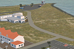
Stage 2 of my rendition of Napier's Ahuriri area. Replaces my previous Perfume Point scenery.
East Pier complex, car parks, boardwalk, public toilet and Napier Sailing Club's starter box.
| Filename: | Perfume_Point_Stage_2.zip |
| License: | Freeware |
| Added: | 2nd October 2016, 02:55:43 |
| Downloads: | 117 |
| Author: | Godfrey Tier |
| Size: | 907.01 KB |
| Category: Flight Simulator X - Scenery | |
| KONT Ontario International Airport, California, USA - v3 |
|
Images related to this file:
File Description:
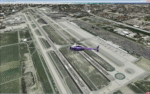
Detailed scenery of Ontario International Airport, California, USA for FSX. The airport is one of the major Southern California basin airports feeding travelers into east Los Angeles and beyond.
| Filename: | KONT_Ontario_International_Airport_California_USA_.zip |
| License: | Freeware, limited distribution |
| Added: | 29th December 2012, 19:42:10 |
| Downloads: | 11,037 |
| Author: | Shehryar Ansari |
| Size: | 37.4 MB |
| Category: Flight Simulator X - Scenery | |
| RAF Lindholme (1940s) |
|
File Description:
RAF Lindholme is located 3.9 miles (6.3 km) south of Thorne and 6.9 miles (11.1 km) north east of Doncaster and was initially called RAF Hatfield Woodhouse and started life as an
expansion scheme aerodrome built on the wide expanse of Hatfield moors, some five miles east of Doncaster. The site, to the east of the A614 Thorne to Bawtry road, was a mile
south of the small village of Hatfield Woodhouse, the name first selected for the new station. Work began in the spring of 1938 taking in approximately 250 acres (1.0 km2) of
pasture for the airfield itself and a further 150 for the camp and support facilities.
RAF lindholme had a long a varied career, details of which cam be found at:- https://en.wikipedia.org/wiki/RAF_Lindholme
Source:Wikipedia
| Filename: | RAF_Lindholme_1940s.zip |
| License: | Freeware |
| Added: | 4th March 2017, 19:57:23 |
| Downloads: | 87 |
| Author: | Terry Boissel |
| Size: | 1.24 MB |
| Category: Flight Simulator X - Scenery | |
| Global Classic AI Ship Traffic V1 for P3D and FSX |
|
Images related to this file:
File Description:
This package for FSX/P3D contains around 250 classic ship models and AI ship routes representing shipping as it looked in the early sixties. From the last steam freight ships to elegant ocean liners, from upgraded WWII destroyers to the then latest types of frigates, and much more. The AI routes cover Western Europe from Norway to the Mediterranean, the US East Coast, South East Asia, and the South East Coast of South America. Cities covered includes Narvik, Bergen, Stavanger, Edinburgh, London, Southampton, Liverpool, Belfast, Gothenburg, Copenhagen, Aarhus, Kiel, Hamburg, Amsterdam, Le Havre, Brest, Lisbon, Gibraltar, Nice, Naples, Palermo, Suez, Quebec, New York, Miami, Havana, Singapore, Bangkok, Ho Chi Minh, Danang, Hong Kong, and many more. Contributors to this package are Erwin Welker, Jean-Pierre Fillion, Dave Garwood, SkippyBing, Knud Kristoffersen, and Henrik Nielsen.
| Filename: | Global_Classic_AI_Ship_Traffic_V1_for_P3D_and_FSX.zip |
| License: | Freeware |
| Added: | 31st January 2021, 19:25:27 |
| Downloads: | 1,511 |
| Author: | Henrik Nielsen |
| Size: | 287.58 MB |
| Category: Flight Simulator 2004 - Scenery | |
| Alexandria CNS4 field near Ottawa, Ontario, Canada |
|
Images related to this file:
File Description:
This was the thirteenth of a projected 16 airfields in the Ottawa area originally posted in 2006; this version has specifically modeled buildings. Alexandria is just a mile east of the town of the same name, 50 miles east of Ottawa International and 16 miles north of Cornwall. It has one grass runway which is 2,020' long and 100' wide and which parallels the road. There are two hangers and a two storey clubhouse, and fuel. And in the summer look out for the gliders doing right hand circuits and the parachutists on vertical finals.
| Filename: | Alexandria_CNS4_field_near_Ottawa_Ontario_Canada.zip |
| License: | Freeware, limited distribution |
| Added: | 16th February 2010, 01:41:39 |
| Downloads: | 441 |
| Author: | Roger Wensley |
| Size: | 1.33 MB |
| Category: Flight Simulator 2002 - Scenery | |
| Herzlia Scenery Version 2 |
|
File Description:
Hi all
It's my second version of this scenery I iupgrad ollmost everthing, removed the chimeny thet make a scond ceminy in the sde dov scenery, ther is steel a couple of static aircraft thet can be seen only in "very dense" setting in the option menu, i attched the afcad file (LLHZ). This is a scenery of "Herzlia" Airfield near to Tel-aviv Israel, It's A small and a very busy Airfield.
| Filename: | Herzlia_Scenery__Version_2.zip |
| License: | Freeware |
| Added: | 12th April 2003, 17:12:54 |
| Downloads: | 1,822 |
| Author: | David Rosenfeld |
| Size: | 4.12 MB |
| Category: Flight Simulator X - Aircraft Repaints, Textures and Modifications | |
| Spitfire Mk IX " Black 57 " Israeli Air Force |
|
File Description:
" Black 57" is currently at the Isreali Air Force Museum , Beersheba - Hatzerim ( LLHB ) . At one time the personal aircraft of Ezer Weizman who became Commander of the Israeli Air Force and later President of Israel .Unknown if this aircraft is still in flying condition ( in photo's until 2005 ) .
This repaint is intended for FS X ( will work in FS 9 - but as a Mk XIV ) . A thumbnail is included as are instructions for installation .
| Filename: | Spitfire_Mk_IX__Black_57__Israeli_Air_Force.zip |
| License: | Freeware |
| Added: | 2nd February 2009, 22:39:41 |
| Downloads: | 408 |
| Author: | John Glanville / Real Air |
| Size: | 4.02 MB |
| Category: Flight Simulator X - AFCAD Files | |
| SBTP - Tupi Airport - Tupi Paulista, Sao Paulo - Brazil |
|
Images related to this file:
File Description:
This airport does not really exist. It was created in the middle of the Atlantic Ocean (as a floating airport) to support operations "off-shore" oil drilling of the "pre-salt". It is located about 450 km south of the city of Rio de Janeiro and 370 km south-southeast of Santos.
| Filename: | SBTP__Tupi_Airport__Tupi_Paulista_Sao_Paulo__Brazi.zip |
| License: | Freeware |
| Added: | 1st December 2014, 23:59:12 |
| Downloads: | 92 |
| Author: | Wellington Silva de Farias |
| Size: | 105.28 KB |
| Category: Flight Simulator X - Aircraft Repaints, Textures and Modifications | |
| Thomas Cook Airlines Boeing 757-300 [Winglets] Egypt Special Livery |
|
Images related to this file:
File Description:
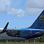
Fictional repaint of Thomas Cook Airlines UK Boeing 757-300 G-JMAA with winglets, in a fictional replica of its little sister aircraft's (G-TCBB, & G-TCBC) 752 Egypt decal livery, for use with the Quality Wings 757 Collection only, available at: www.qwsim.com.
Only tested in FSX but should work fine in FS9 also.
| Filename: | Thomas_Cook_Airlines_Boeing_757300_Winglets_Egypt_.zip |
| License: | Freeware |
| Added: | 26th April 2012, 21:48:25 |
| Downloads: | 1,354 |
| Author: | Jason Smart/ Quality Wings |
| Size: | 9.95 MB |
| Category: Flight Simulator 2004 - Scenery | |
| Alaska South Slope 7; Kobuk OBU & Dahl Creek DCK |
|
Images related to this file:
File Description:
There are four main northwestern Alaska towns which are serviced by Alaska Airlines, and from which local flights spread out. The northernmost is Barrow. Southwest of Barrow is Kotzebue, then Nome, and the furthest south is Bethel (not yet made). This is a continuation of the series for the flights from Kotzebue, 170 miles to the east where Kobuk is on the bank of the Kobuk River, and Dahl Creek is 2 miles to the north. Kobuk is a small village on the Kobuk River, like Ambler and Shungnak, but with a population of only around 150. The river is the reason for the existance of the villages as it served (and still does) as both a source of food and a transport route. The airfield is just beside the village, with a runway around 4,500 feet of lit gravel and aligned 09-27, with PAPI on both ends. There are scheduled flights by Era (now renamed Ravn) and by Bering Air, both of them originating in Kotzebue and routing east to Ambler, Shungnak, Kobuk, and then back again. The AI includes these flights along with Everts Air and GA. The FS9 airfield has been relocated by approximately a mile to the correct position, and the elevation accordingly adjusted. The Dahl Creek strip is publicly owned, with no maintenance and a deteriorating gravel runway that has not long to survive. This probably does not work properly without Ultimate Terrain Alaska Canada as the village is now on the river bank. I am presuming that you have downloaded and installed Nome PAOM, along with the instructions on how to adjust Ultimate Terrain Alaska Canada to get the most realistic results. If you are not making the UT adjustments then you may be seeing duplicated roads, as I am including new local dirt or gravel roads to connect village to airfield etc to get the best overall result; I will not be making alternate versions.
| Filename: | Alaska_South_Slope_7_Kobuk_OBU__Dahl_Creek_DCK.zip |
| License: | Freeware, limited distribution |
| Added: | 13th October 2016, 18:10:08 |
| Downloads: | 235 |
| Author: | Roger Wensley |
| Size: | 2.94 MB |


© 2001-2026 AVSIM Online
All Rights Reserved
Privacy Policy |