
Where Flight Simulation Enthusiasts Gather from Around the World!
AVSIM Library - Search Results

| Category: Flight Simulator 2004 - Scenery | |
| NZ Rural Airstrips, v3 |

|
Images related to this file:
File Description:
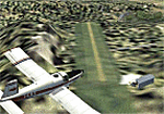
Replaces my previous versions. 9 more strips included. Gisborne area. Requires Christian Stock's payware NZ mesh in the form of "Mountains of New Zealand" and topo in the form of "Lakes and Rivers of New Zealand".
| Filename: | NZ_Rural_Airstrips_v3.zip |
| License: | Freeware |
| Added: | 17th April 2010, 16:18:18 |
| Downloads: | 147 |
| Author: | Godfrey Tier |
| Size: | 2.37 MB |
| Category: Flight Simulator X - Miscellaneous Files | |
| Morocco Vectors VFR |
|
Images related to this file:
File Description:
This project add and update vectors for Morocco and Western Sahara. Accurate coastline, lakes, roads, railways and river/streams. This vectors are optimized with Terrain Mesh SRTM 1 arc sec (LOD11). Scenery for FSX//P3Dv1/2/3/4.
| Filename: | Morocco_Vectors_VFR.zip |
| License: | Freeware |
| Added: | 9th June 2017, 21:04:48 |
| Downloads: | 771 |
| Author: | Giovanni Miduri |
| Size: | 20.49 MB |
| Category: Flight Simulator 2004 - Scenery | |
| La Tortuga Island - SyDesigns |
|
File Description:
La Tortuga Island Scenery for Flight Simulator 2004: It is an accurate depiction of this paradise located near Margarita Island in Venezuela. It includes two airfields, new coastlines, mesh, landclass, visual details for VFR flying, and animated scenery.
| Filename: | La_Tortuga_Island__SyDesigns.zip |
| License: | Freeware, limited distribution |
| Added: | 3rd August 2006, 03:52:22 |
| Downloads: | 4,324 |
| Author: | Sabino Yacobone & Arnoldo Perdomo |
| Size: | 6.72 MB |
| Category: Flight Simulator 2004 - Scenery | |
| RANGITAIKI - NZRK |
|
Images related to this file:
File Description:
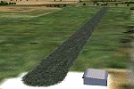
Simple rendition of this aerodrome, 16nm south-east of Taupo, (NAZP), New Zealand. Made for Christian Stock's NZ mesh in the form of "Mountains of New Zealand"
and topo in the form of "Lakes and Rivers of New Zealand".
| Filename: | RANGITAIKI__NZRK.zip |
| License: | Freeware |
| Added: | 6th February 2011, 03:46:28 |
| Downloads: | 205 |
| Author: | Godfrey Tier |
| Size: | 183.53 KB |
| Category: Flight Simulator 2004 - Scenery | |
| FYKT, J. G. H. Van Der Wath airport, Keetmanshoop, Namibia for FS9 |
|
File Description:
Based on googleEarth picture. Ez-scenery and rwy12 objects included. Compatible with Holger Sandmann's Namibia LOD9 Terrain mesh (namibia_ne.zip, namibia_nw.zip, namibia_se.zip, namibia_sw.zip, namibia_cp.zip) as well as his namibia_scenery_updates.zip, all found at avsim.com. (re-upload, originally uploaded 23rd November 2008)
| Filename: | FYKT_J_G_H_Van_Der_Wath_airport_Keetmanshoop_Namib.zip |
| License: | Freeware |
| Added: | 16th May 2010, 23:59:11 |
| Downloads: | 1,080 |
| Author: | Detlev J. Rohmer |
| Size: | 5.88 MB |
| Category: Prepar3D V1-4 - Scenery | |
| EBAV - Avernas Le Bauduin - Hannut, Belgium for P3Dv4 |
|
File Description:
EBAV - Avernas Ultra light airfield (with new runway) for P3Dv2-v3-v4 & Megascenery Belgium photoscenery (or home made photoscenery). The scenery includes the airfield (for default mesh) and its surroundings (+- 3X3 nm). A file is inclued for FSX & P3Dv1 user.
| Filename: | EBAV__Avernas_Le_Bauduin__Hannut_Belgium_for_P3Dv4.zip |
| License: | Freeware |
| Added: | 17th December 2017, 20:42:35 |
| Downloads: | 453 |
| Author: | Aimé Leclercq |
| Size: | 141.24 MB |
| Category: Flight Simulator X - Scenery | |
| Quebec Elevation 38m (LOD10) (2/5) |
|
File Description:
FSX 38m (Lod10) terrain mesh files of the province of Quebec, Canada (range : N45-N52, W56-W80) (5 zip files).
**********************
Donnees d'elevation de terrain (FSX - 38 metres) de la province de Quebec, Canada (couverture : N45-N52, W56-W80)
| Filename: | Quebec_Elevation_38m_LOD10_25.zip |
| License: | Freeware, limited distribution |
| Added: | 22nd December 2009, 12:28:21 |
| Downloads: | 6,473 |
| Author: | Gilles Gauthier |
| Size: | 44.94 MB |
| Category: Flight Simulator X - Scenery | |
| Quebec Elevation 38m (LOD10) (3/5) |
|
File Description:
FSX 38m (Lod10) terrain mesh files of the province of Quebec, Canada (range : N45-N52, W56-W80) (5 zip files).
**************************
Donnees d'elevation de terrain (FSX - 38 metres) de la province de Quebec, Canada (couverture : N45-N52, W56-W80).
| Filename: | Quebec_Elevation_38m_LOD10_35.zip |
| License: | Freeware, limited distribution |
| Added: | 31st January 2007, 21:45:36 |
| Downloads: | 6,483 |
| Author: | Gilles Gauthier |
| Size: | 39.48 MB |
| Category: Flight Simulator X - Scenery | |
| Quebec Elevation 38m (LOD10) (1/5) |
|
File Description:
FSX 38m (Lod10) terrain mesh files of the province of Quebec, Canada (range: N45-N52, W56-W80) (5 zip files).
*************************
Donnees d'elevation de terrain (FSX - 38 metres) de la province de Quebec, Canada (couverture : N45-N52, W56-W80)
| Filename: | Quebec_Elevation_38m_LOD10_15.zip |
| License: | Freeware, limited distribution |
| Added: | 31st January 2007, 21:44:57 |
| Downloads: | 10,987 |
| Author: | Gilles Gauthier |
| Size: | 44.37 MB |
| Category: Flight Simulator X - Scenery | |
| Quebec Elevation 38m (LOD10) (5/5) |
|
File Description:
FSX 38m (Lod10) terrain mesh files of the province of Quebec, Canada (range: N45-N52, W56-W80) (5 zip files).
*************************
Donnees d'elevation de terrain (FSX - 38 metres) de la province de Quebec, Canada (couverture : N45-N52, W56-W80)
| Filename: | Quebec_Elevation_38m_LOD10_55.zip |
| License: | Freeware, limited distribution |
| Added: | 31st January 2007, 21:46:00 |
| Downloads: | 7,604 |
| Author: | Gilles Gauthier |
| Size: | 39.44 MB |
© 2001-2026 AVSIM Online
All Rights Reserved
Privacy Policy |