
Where Flight Simulation Enthusiasts Gather from Around the World!
AVSIM Library - Search Results

| Category: Flight Simulator 2004 - Scenery | |
| South Africa (Johannesburg(Transvaal)/Swasiland/Lesotho/Orange Freestate- 76M SRTM TERRAIN MESH) Part 2 |

|
File Description:
This mesh of South Africa includes beautiful areas of Transvaal(Johannesburg), Swasiland, Orange Freestate and Lesotho.It comes in 3 files. Part 2 of 3.
All the 3 files cover the area from S25 E26(!) to S30 E31.
| Filename: | South_Africa_JohannesburgTransvaalSwasilandLesotho.zip |
| License: | Freeware, limited distribution |
| Added: | 24th April 2004, 02:25:21 |
| Downloads: | 4,207 |
| Author: | Michael Speck |
| Size: | 15.87 MB |
| Category: Flight Simulator 2004 - Scenery | |
| South Africa (Johannesburg(Transvaal)/Swasiland/Lesotho/Orange Freestate- 76M SRTM TERRAIN MESH) Part 1 |
|
File Description:
This mesh of South Africa includes beautiful areas of Transvaal(Johannesburg), Swasiland, Orange Freestate and Lesotho.It comes in 3 files. Part 1 of 3.
All the 3 files cover the area from S25 E31 to S30 E31.
| Filename: | South_Africa_JohannesburgTransvaalSwasilandLesotho.zip |
| License: | Freeware, limited distribution |
| Added: | 24th April 2004, 02:06:43 |
| Downloads: | 5,021 |
| Author: | Michael Speck |
| Size: | 4.84 MB |
| Category: Flight Simulator 2004 - Miscellaneous Files | |
| FS Kneeboard Utilities 2004 |
|
File Description:
A general utility for Flight Simulator 2004 kneeboard. It provides a full web browser with back and forward buttons, a user friendly interface, a print function for webpages, documents and images, quick acces to weather and chart services, a online logbook, chat and forum, a chart viewer, a notepad for writing down frequencies, aircrat checklists and many other functions, all this inside flight simulator without having to minimize it by using the kneeboard. You can browse the internet, search for charts and metar reports, print them and even move file and folder in the computer while flying at 35000 ft. without ever seeing the desktop.
| Filename: | FS_Kneeboard_Utilities_2004.zip |
| License: | Freeware |
| Added: | 4th November 2004, 00:05:26 |
| Downloads: | 7,854 |
| Author: | Grigoriu Alexandru |
| Size: | 1.06 MB |
| Category: Fly! II - Navigation | |
| US Terminal Area Charts for Fly! II (ECW Files) |
|
File Description:
Terminal Area Charts for the continental United States and Puerto Rico in ECW (ERMapper Compressed Wavelet) format for Fly! II. This download contains just the ECW images; in order to be usable in the Fly! II chart viewer, you must also download and install the associated MAP files.
These charts are simply conversions of JPG images uploaded to AVSIM by Matt Fox. Thanks to Matt for making these charts available in the first place! Conversion from JPG to ECW was done with the ECW plugin for PaintShop Pro v6 with desired compression ratio of 25:1.
THESE CHARTS ARE NOT TO BE USED FOR REAL-WORLD NAVIGATION!
| Filename: | US_Terminal_Area_Charts_for_Fly_II_ECW_Files.zip |
| License: | Freeware |
| Added: | 9th March 2005, 13:38:27 |
| Downloads: | 207 |
| Author: | Chris Wallace |
| Size: | 58.08 MB |
| Category: Fly! II - Navigation | |
| Alaska Terminal Area Charts for Fly! II (ECW Files) |
|
File Description:
Terminal Area Charts for Anchorage and Fairbanks, Alaska, in ECW (ERMapper Compressed Wavelet) format for Fly! II. This download contains just the ECW images; in order to be usable in the Fly! II chart viewer, you must also download and install the associated MAP files.
These charts are simply conversions of JPG images uploaded to AVSIM by Matt Fox. Thanks to Matt for making these charts available in the first place! Conversion from JPG to ECW was done with the ECW plugin for PaintShop Pro v6 with desired compression ratio of 25:1.
THESE CHARTS ARE NOT TO BE USED FOR REAL-WORLD NAVIGATION!
| Filename: | Alaska_Terminal_Area_Charts_for_Fly_II_ECW_Files.zip |
| License: | Freeware |
| Added: | 10th March 2005, 05:38:34 |
| Downloads: | 289 |
| Author: | Chris Wallace |
| Size: | 8.24 MB |
| Category: Flight Simulator X - Aircraft Repaints, Textures and Modifications | |
| jetBlue "Blue York Yankee" Airbus A320 WL CFM (N413JB) |
|
Images related to this file:
File Description:
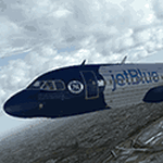
Fictional jetBlue livery for the Aerosoft Airbus A320 CFM with Winglets. This was a project request from a viewer fan of my channel that makes excellent FSX 'Real As It Gets' videos. He wanted a tribute plane for the New York Yankees for jetBlue and I delivered. Now that he is done with the video that uses this aircraft I am releasing it to the public so you can zoom up into the sky and show your Yankee pride. Instructions are in the ZIP file readme. The easiest way to install is to use the Aerosoft Livery Manager software that came with your Airbus Extended purchase. Enjoy!
| Filename: | jetBlue_Blue_York_Yankee_Airbus_A320_WL_CFM_N413JB.zip |
| License: | Freeware |
| Added: | 29th June 2015, 00:02:48 |
| Downloads: | 1,014 |
| Author: | Brian Navy |
| Size: | 5.43 MB |
| Category: Flight Simulator 2002 - Scenery | |
| New 300-m (LOD7) Terrain Mesh of British Columbia and Southeast Alaska #4 |
|
File Description:
Mid-resolution (300-m) terrain mesh for the entire province of British Columbia (950,000 square km) and the Alaska panhandle southeast of N60 W139. Made from 250m-resolution source data without oversampling. Easy on frame rates and hard drive space. It transforms the rounded mountains of the default terrain mesh into a much more realistic representation of the diverse topography of this beautiful corner of the world. Experience the spectacular scenery between Vancouver and Atlin, Juneau and Fort St. John, and Mount Robson to Clayoquot Sound. Fourteen independent mesh tiles allow you to select the region(s) you like best. Several high-resolution add-on meshes will be uploaded separately. By Holger Sandmann. Part 4 of 4: All areas between 48 and 51 degrees North. Note: this part contains updated read-me.txt and .pdf files - please use these instead of the ones distributed with the first three parts!
| Filename: | New_300m_LOD7_Terrain_Mesh_of_British_Columbia_and.zip |
| License: | Freeware, limited distribution |
| Added: | 17th January 2003, 20:22:07 |
| Downloads: | 3,677 |
| Author: | Holger Sandmann |
| Size: | 6.34 MB |
| Category: Flight Simulator 2002 - Scenery | |
| Lundy Island UK |
|
File Description:
This scenery represents Lundy Island in the Bristol Channel UK it features a small village with a church, a revolving wind turbine, 3 lighthouses and the 400 metre grass strip, designed primarily for use with addon mesh terrain.
| Filename: | Lundy_Island_UK.zip |
| License: | Freeware |
| Added: | 22nd October 2002, 15:20:47 |
| Downloads: | 1,218 |
| Author: | Nick Ryall and Steve Mullen |
| Size: | 1020.92 KB |
| Category: Flight Simulator 2002 - Scenery | |
| Peninsula Point Pullout, Ketchikan, Alaska |
|
File Description:
FS2002 Scenery -- Peninsula Point Pullout, Ketchikan, Alaska. Semi fictitious. A seaplane facility located at the juncture of Tongass Narrows and the mouth of Ward Cove. Designed with Ed Denny’s FS2000 Alaska mesh. Requires TREES_V3.ZIP by Gerrish Gray.
| Filename: | Peninsula_Point_Pullout_Ketchikan_Alaska.zip |
| License: | Freeware |
| Added: | 23rd April 2003, 03:56:36 |
| Downloads: | 1,628 |
| Author: | Morton Rupp |
| Size: | 2.74 MB |
| Category: Flight Simulator 2004 - AFCAD Files | |
| Hal-Far RNAS Malta V2 |
|
File Description:
Revised AFCAD with buildings for Hal-Far Royal Naval Air Station Malta circa 1958-1962.Suitable for the default scenery only, not tested with commercial or other land classes / mesh.
Thanks to Ted Andrews for his RAF buildings.
| Filename: | HalFar_RNAS_Malta_V2.zip |
| License: | Freeware |
| Added: | 22nd December 2008, 03:14:57 |
| Downloads: | 454 |
| Author: | owen morris |
| Size: | 3.07 MB |
© 2001-2026 AVSIM Online
All Rights Reserved
Privacy Policy |