
Where Flight Simulation Enthusiasts Gather from Around the World!
AVSIM Library - Search Results

| Category: Flight Simulator X - Scenery | |
| Polish Airports VOL. 3 X DEMO |

|
Images related to this file:
File Description:
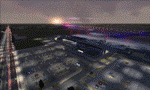
POLISH AIRPORTS VOL. 3 X DEMO is a package of detailed sceneries of EPPO Poznan, EPWR Wroclaw and EPBY Bydgoszcz airports in Poland, fully compatible with FSX, P3Dv1, P3Dv2 (till v2.1).
This product is a fully functional DEMO version of the commercial payware product. It features same airports layout as in the full version but with limited 3D objects and low resolution textures. Using this free demo ensures no problems with online (VATSIM, IVAO, multiplayer etc.) flying in case some users use the payware scenery and some don't.
Poznan-Lawica Henryk Wieniawski Airport (POZ/EPPO), built in 1913, is one of the oldest airports in Poland and the 6th largest airport in Poland. Bydgoszcz Ignacy Jan Paderewski Airport (BZG/EPBY) is a Polish regional airport in the city of Bydgoszcz. EPBY is the 9th largest airport in Poland offering the runway 08/26 which is 2,500 x 60 m. Wroclaw Copernicus Airport (WRO/EPWR) is an international commercial airport in Wroclaw in southwestern Poland. EPWR is the 4th largest airport in Poland having one runway, two passenger terminals and one cargo terminal.
The product is equipped with an automatic installer, which means that the scenery will be automatically added to the Flight Simulator Scenery Library. Please uninstall all previous versions of this airport you may have installed before. Please make also sure that no duplicate AFCAD files are installed.
Enjoy your virtual flying with Drzewiecki Design!
| Filename: | Polish_Airports_VOL_3_X_DEMO.zip |
| License: | Commercial demo |
| Added: | 2nd September 2015, 22:20:44 |
| Downloads: | 1,614 |
| Author: | Drzewiecki Design |
| Size: | 42.23 MB |
| Category: Prepar3D V1-4 - Aircraft Repaints, Textures and Modifications | |
| Pan Am L-049 Constellation |
|
Images related to this file:
File Description:

Pan American World Airways livery for the A2A COTS L049 Constellation. These textures will also work in FSX.
Pan American World Airways, known from its founding until 1950 as Pan American Airways[1] and commonly known as Pan Am, was the principal and largest international air carrier in the United States from 1927 until its collapse on December 4, 1991. Founded in 1927 as a scheduled air mail and passenger service operating between Key West, Florida, and Havana, Cuba, the airline became a major company credited with many innovations that shaped the international airline industry, including the widespread use of jet aircraft, jumbo jets, and computerized reservation systems. It was also a founding member of the International Air Transport Association (IATA), the global airline industry association.[3] Identified by its blue globe logo ("The Blue Meatball"), the use of the word "Clipper" in aircraft names and call signs, and the white pilot uniform caps, the airline was a cultural icon of the 20th century. In an era dominated by flag carriers that were wholly or majority government-owned, it was also the unofficial overseas flag carrier of the United States. During most of the jet era, Pan Am's flagship terminal was the Worldport located at John F. Kennedy International Airport in New York City.(Source: Wikipedia)
All logos and texts had to be recreated, since there was nothing usable on the net.
| Filename: | Pan_Am_L049_Constellation.zip |
| License: | Freeware, limited distribution |
| Added: | 6th January 2017, 08:29:29 |
| Downloads: | 1,174 |
| Author: | Eberhard Haberkorn / A2A |
| Size: | 65.23 MB |
| Category: Flight Simulator 2004 - Scenery | |
| Repulse Bay CYUT in Nunavut Canada |
|
Images related to this file:
File Description:
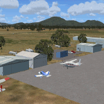
This is a scenery that I started in 2013, temporarily abandoned when I found there was a fault in the coastline that reduced it all to straight lines, and then totally forgot about. Until now, when I discovered that while I had made the Repulse Bay terminal building I had mysteriously not made the scenery. Investigation revealed the reason why and here it is with a coastline that has been repaired to the extent that the fault allowed. Repulse Bay has a population of around 1,100 and since 2015 has been officially named Naujaat, the traditional Inuit name. It is located exactly on the arctic circle on the northern extension of the western side of Hudson Bay, in a large bay off the northern tip of Southampton Island. Coral Harbour is on the far side of the island, 180 miles to the south. The airfield is alongside the town and the coast, with the runway 3,400 feet of gravel with PAPI at both ends, aligned 161T-341T with "T" standing for true as opposed to the unreliable magnetic bearing this far north. The regular scheduled flights are by Air Baffin (an Air Nunavut subsiduary), connecting to Iqaluit some 550 miles to the east. The helicopters are there in the summer with their own fuel in drums around their own parking apron. They land directly on the apron, which cannot be replicated in AI, so they are present only as parked choppers and not flying ones.
| Filename: | Repulse_Bay_CYUT_in_Nunavut_Canada.zip |
| License: | Freeware, limited distribution |
| Added: | 6th September 2018, 00:34:38 |
| Downloads: | 179 |
| Author: | Roger Wensley |
| Size: | 7.87 MB |
| Category: Flight Simulator 2004 - Scenery | |
| Sachs Harbour CYSY in Northwest Territories, Canada |
|
Images related to this file:
File Description:
Sachs Harbour is on the southwest coast of Banks Island on the north side of Amundsen Gulf, around 240 miles northeast of Tuktoyaktuk and 180 miles northwest of Ulukhaktok. The village is the only permanent settlement on the island, and is located where it is to benefit from the harbour shelter provided by offshore land. The population is only 130 or so folks, who live on hunting and fishing with some tourism. One claim to fame is that the island is home to threequarters of the world's population of muskoxen and the second is the largest goose colony in North America. The airfield is on the plateau just above the village at 282 feet ASL. The gravel runway 084T/264T (true bearings in Northern Domestic Airspace) is 4,000' long and 100' wide and lit. The apron is on the south side at the centre of the runway and there is a new terminal building; there is JetA fuel available and perhaps 100LL in drums. To the west of the airfield are the deserted buildings of what was once a Department Of Transport weather station. Aklak Airlines flights (operated by Kenn Borek) fly to Sachs Harbour from Inuvik three times a week in summer and twice a week at other times; the AI will be included in the post of a revised Aklavik, and Inuvik revised and Tuktoyaktuk should be fully installed BEFORE Sachs Harbour.
| Filename: | Sachs_Harbour_CYSY_in_Northwest_Territories_Canada.zip |
| License: | Freeware, limited distribution |
| Added: | 14th May 2012, 17:20:09 |
| Downloads: | 394 |
| Author: | Roger Wensley |
| Size: | 6.16 MB |
| Category: Flight Simulator X - Scenery | |
| Mid West Victoria v2 for ORBX v2. 14 airports. YARA YSWL YMBU YSTA YDOD YWYF YBIR YHPN YKER YSLK YSWH YNHL YHSM YWKB |
|
Images related to this file:
File Description:
'Mid Western Victoria v2' is made to match ORBX Australia v2 scenery. Use 'Mid West Victoria update' for ORBX v1 or no ORBX. NOTE this is an UPDATE with Horsham replacing Hamilton in the instructions (it is Horsham in the actual scenery). There are 14 airports starting at Ararat and extending up to the Murray at Swan Hill. YARA Ararat YSWL Stawell YMBU Maryborough YSTA Saint Arnaud YDOD Donald YWYF Wycheproof YBIR Birchip YHPN Hopetoun YKER Kerang YSLK Sealake YSWH Swanhill YNHL Nhill YHSM Horsham YWKB Warracknabeal. A lot of airports but this is several hundred hours of effort over many months. ORBX has done these as they have done every airport included with FSX in Australia to a reasonable standard. If I had not already done them for ORBX V1 I would not have bothered. However these are better than ORBX because the surroundings have been modified to match real life. Towns have been added or shifted. Forests cut down or added. Race courses, sewage treatment ponds and other stuff added. Local obstacles (towers etc) added. There are 6 custom terminal buildings accurate to real life. Included is an AI traffic file that covers airports that dont already have AI. These files are for Flight Simulator X. Made using Airport Design Editor using some objects borrowed from Robert Budd's excellent Baccus Marsh and 'Static aircrafts' by Jean-Pierre Fillion. REQUIRED The scenery is designed to interface with ORBX FTX_AU V2 scenery for Australia (payware).
| Filename: | Mid_West_Victoria_v2_for_ORBX_v2_14_airports_YARA_.zip |
| License: | Freeware |
| Added: | 2nd May 2020, 23:11:14 |
| Downloads: | 255 |
| Author: | Colin Jeffery |
| Size: | 10.49 MB |
| Category: Flight Simulator 2004 - Scenery | |
| Smithers CYYD in British Columbia, Canada, Updated |
|
Images related to this file:
File Description:
Made in December 2018 as an update of the original post of 2014, to correct the apron markings, revise the AI, increase the number of GA parking spots, and most importantly to correct the runway lighting by adding the missing approach lights. This scenery is complete and can be installed as-is without first installing the 2014 version. Smithers is in northwest BC, 60 miles east and a bit north of Terrace, and directly east of the southern border of Alaska. The town has a population of 5,500 and is set in a north-south valley between mountains, the most impressive of which is Hudson Bay Mountain to the west. The airport is to the north of the town and has a single runway of 7,544 feet, aligned 33-15. The main user is Central Mountain Air, who are headquartered in Smithers and have a large maintenance hangar there next to the terminal building. The airport has scheduled flights by Central Mountain Air, Jazz, and Hawk Air, which are in the AI. The AI provided here is a new CYYD traffic bgl; in total the AI also includes a Dawson Creek traffic bgl (recently revised and posted) plus a Terrace traffic bgl (which will shortly be revised and posted). An Electra of Conair (who are the largest operator of fire fighting planes in BC, and have re-fill tanks in Smithers) is included and also a HS 748 of Air North.
| Filename: | Smithers_CYYD_in_British_Columbia_Canada_Updated.zip |
| License: | Freeware, limited distribution |
| Added: | 4th January 2019, 18:08:03 |
| Downloads: | 216 |
| Author: | Roger Wensley |
| Size: | 14.22 MB |
| Category: Flight Simulator X - AFCAD Files | |
| DAOO - Oran Ahmed Ben Bella International Airport (Es Senia), Algeria |
|
Images related to this file:
File Description:
The main airport of Oran was recently renamed Oran Ahmed Ben Bella International in honor of the nation's founding president. The airport recently underwent EUR 20 million renovations which added the new 07R/25L runway and extended and renamed the existing 07L/25R runway as well as taxiway construction. Renovations were also done to the main parking apron and terminal building. This airport serves as a hub for Air Algeria and Aigle Azur with service to points in Africa, the Middle East and Europe. Several other airlines serve the airport with Air France beginning service from Paris in the Summer of 2013. The city of Oran (population approx. 759,645) is the second largest city in Algeria and an important industrial, educational and cultural center in Alegria.
Features:
*Expanded parking apron
*Parking ramp for cargo (v1.2)
*Taxiways properly desginated (v1.2)
*New runway 07R/25L
*Extension and renaming of runway 07/25 to 07L/25R
*Parking spots for commercial traffic
*Seperate parking areaa for GA traffic
*Misc airport buildings added
*Airport vehicles and objects throughout the airport
*Fuel service vehicles
*Date palms added
*Military area on the north side of the field with a helipad
*Version 1.1 corrects an issue with a misplaced taxi sign as well as a few minor oversights
*Version 1.2 adds correctly labeled taxiway designators (was able to get a hold of recent accurate charts) as well as correct ILS allignment for 25L
| Filename: | DAOO__Oran_Ahmed_Ben_Bella_International_Airport_E.zip |
| License: | Freeware |
| Added: | 13th April 2013, 23:43:00 |
| Downloads: | 1,140 |
| Author: | Jaison Diaz / Endeavour ai |
| Size: | 138.08 KB |
| Category: Flight Simulator 2004 - Scenery | |
| Maurice Bishop TGPY on Grenada in the Caribbean |
|
Images related to this file:
File Description:
Grenada island is 17 miles south of the southernmost island of the Grenadines, Carriacou; there are some smaller islands between the two. Grenada is 18 miles long and around 8 miles wide, has an estimated population of 110,000, and produces a very large part of the world's annual nutmeg harvest. The capital, St Georges, is by far the largest town and is at the southern end of the island, with the airport close by.
The airport is now called Maurice Bishop, but for some years was called Point Salines. The runway is just over 9,000 feet long and oriented 10/28. Point Salines replaced Pearl Airport, which is on the east coast 12 miles northeast of St Georges and was difficult to expand as the runway had mountains at one end and the sea at the other. Pearl is now closed; it is included here but only as a visual landmark with "closed" markings. There are regular international flights from North America and Europe, some of which are seasonal only (Air Canada for instance) and local connecting flights by LIAT and SVG. I retained the default control tower as it is some distance away. In real life it is also some distance away and on a hill northwest of the terminal. Which is why I did not take photos from which I would have made the real one. The hill does not feature in FS9.
| Filename: | Maurice_Bishop_TGPY_on_Grenada_in_the_Caribbean.zip |
| License: | Freeware, limited distribution |
| Added: | 11th June 2013, 23:28:17 |
| Downloads: | 825 |
| Author: | Roger Wensley |
| Size: | 7.38 MB |
| Category: Flight Simulator 2004 - Scenery | |
| Prudhoe Bay area on Alaska North Slope US |
|
Images related to this file:
File Description:
The Prudhoe Bay area of the Alaska north slope is dominated by all the equipment and machinery that is necessary for the extraction of oil and its transfer by the pipeline that reaches south to Valdez. Prudhoe Bay airport is now closed, and its replacement just to the south is Deadhorse PASC, with numerous storage, maintenance, and accomodation areas immediately to the north of the apron, and others adjacent to the road between the two. The runway is just under 6,500 feet with approach lights at both ends and ILS on 04 (true heading of 75 degrees). This scenery reflects the overall situation in 2011 and oil production facilities and buildings are included here. The airport buildings and those close to the airport are replicas of the real life buildings; while as distance increases the accuracy fades somewhat there are everywhere replica trucks and cross country vehicles that are true to life. Deadhorse handles around 7,000 passengers per month as staff are rotated in and out on Alaska Air and ERA flights and by oil company private flights. There are also freight flights to complement the trucking effort up the Dalton Highway. The Alaska Airlines terminal building and ERA (the red buildings nearby) are at one end of the apron, while at the other end is a very large and new green terminal, storage, hangar building built by the airport authority. All of the airport components, runways, taxiways, and aprons, are built up on a gravel base to raise them above the surrounding terrain that floods with melting snow, freezes, or dries out, according to the seasons. There are other new airstrips included here that serve the oil industry. Around 33 miles to the east is Badami PABP airport servicing a subsiduary oil producing area, with 5,000 feet of gravel runway. Some 28 miles to the west of Deadhorse is Ugnu-Kuparuk UBW with just over 6,000 feet of gravel (gravel in 2011, it is now asphalted) servicing oil production by Conoco Phillips, which uses 737's to fly staff in and out. A further 32 miles west is Alpine AK15 with 5,400 feet of gravel and also served by the Conoco Phillips 737's. To the south of Alpine and connected by road is the village of Nuiqsut. To the north of Alpine and reachable only by air in the delta of the Sagavanirktok River is CD-3, an oil collection and pump station area with another gravel runway of 3,000 feet. Other airstrips that were prviously posted are now updated, Nuiqsut and Oliktok. I experimented, but decided against trying to reproduce the several hundred miles of pipelines. The are new AI aircraft, and there are notes regarding downloading. There is a new "cement" texture (not its name, but used as that by SBuilder) for the built up gravel bases. It is slightly darker than the original but not so much that any previous use will be spoilt. You may wish to download my "Alaska Frozen Rivers and Lakes" which freezes lakes and the northern sea and makes them landable on wheels.
| Filename: | Prudhoe_Bay_area_on_Alaska_North_Slope_US.zip |
| License: | Freeware, limited distribution |
| Added: | 19th December 2017, 00:38:06 |
| Downloads: | 583 |
| Author: | Roger Wensley |
| Size: | 28.54 MB |
| Category: Microsoft Flight Simulator (2020) - Scenery | |
| UGAM Ambrolauri Airport, Georgia [MSFS] |
|
Images related to this file:
File Description:
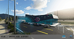
Ambrolauri Ambrolauri (Georgian: áƒáƒ›áƒ‘რáƒáƒšáƒáƒ£áƒ ი) is a city in Georgia, located in the western part of the country, on both banks of the Rioni river, at the elevation of 550 m above sea level. It is a self-governing city. At the same time, the city serves as the seat of the Racha-Lechkhumi and Kvemo Svaneti regional administration and the Ambrolauri Municipality. According to the 2014 census, the city had a population of 2,047. Its area is 1.6 km². Ambrolauri is first recorded in the 17th century as a place, where one of the palaces of the kings of Imereti was located. It acquired the city status in 1966 and became a self-governing city with its own municipal government in 2014. The Airport The airport is nestled into the Caucasus mountains right at the bank of the river Rioni. It has a single runway of 1100 m length and caters small propeller aeroplanes. The apron has space for two planes at a time and caters up to 50 passengers at one time. In the Simulator The virtual airport is very close to its real-world counterpart. All the buildings at and near the airport are modelled and the terminal even has an interior that can be seen from outside. The look and feel from a trip to the Racha region is definitely there. In real life, only small planes fly to the airport but that shouldn't stop you to bring planes from the size of the Dash 8.
| Filename: | UGAM_Ambrolauri_Airport_Georgia_MSFS.zip |
| License: | Freeware, limited distribution |
| Added: | 30th December 2020, 18:16:07 |
| Downloads: | 179 |
| Author: | David Hilker |
| Size: | 72.32 MB |
© 2001-2026 AVSIM Online
All Rights Reserved
Privacy Policy |