
Where Flight Simulation Enthusiasts Gather from Around the World!
AVSIM Library - Search Results

| Category: Flight Simulator X - Scenery | |
| CYQQ - Comox Valley |

|
File Description:
The Comox valley Airport is located in Comox, East side of Vancouver island, British Columbia, within a three hour drive to most Vancouver Island locations. Comox Valley is, as well, one of many destination for Air Canadian Sun from Air Canadian V.A!
I have re-organised the entire airport layout while keeping the main frame. I have included Parking lot and traffic (static) in the south, the cargo area in the north west, the north east parking, readjusted the 3 helipads to their correct spot, added some parking spot for small and medium aircrafts as well as cargo.
*Important* :Note the ILS fix created by Jim Vile that is suiting as well the airport. Thank you for that! ;)
I have reassigned the main Rwy to 12/30 instead of 11/29 done by FSX including all taxi sign. All maintenance hangar and closed taxiway on the east side.
The push back trucks at the main terminal south and cargo north are set to auto, enjoy a push back! ;)
| Filename: | CYQQ__Comox_Valley.zip |
| License: | Freeware |
| Added: | 8th March 2009, 15:47:24 |
| Downloads: | 2,176 |
| Author: | Daniel Louvet |
| Size: | 545.82 KB |
| Category: Flight Simulator X - Scenery | |
| Area 51 V1.1 |
|
Images related to this file:
File Description:
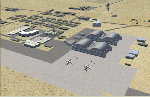
In V1 I added tower comms, taxiways/signs, and deleted start points for all those dirt & other closed runways and made the primary/secondary 14/32.
In V1.1 I have gone through the rest of the airport, aligning and cleaning up scattered oddly placed buildings and placed them in a logical manner - aligned with roads. with parking lots and/or pavement or concrete around their base. Gravel roads added thru the warehouses, sand maintenance roads to water tower and power station, Rec center pool and ballfield touched up. Fire station is in same place but turned towards flight line and added the trucks an ambulance. Fencing all around the flight line.
Also you get the F-117 and Janet 737 WITH traffic file. The Janet 737 is the shuttle aircraft for the Area 51 workers. Watch as the Janet flights arrive each morning from KLAS and depart each night Mon-Fri. KLAS (Las Vegas) Bgl also included with assigned parking at the Janet Terminal.
| Filename: | Area_51_V11.zip |
| License: | Freeware |
| Added: | 24th October 2014, 11:47:01 |
| Downloads: | 2,458 |
| Author: | Jeff Reed |
| Size: | 17.66 MB |
| Category: Flight Simulator 2004 - Scenery | |
| CYYD - Smithers Regional Airport - Smithers, British Columbia, Canada |
|
Images related to this file:
File Description:
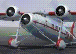
Smithers is in northwest BC, 60 miles east and a bit north of Terrace (my previous post) and directly east of the southern border of Alaska, 430 miles north of Vancouver on the Yellowhead highway. The town has a population of 5,500 and is set in a north-south valley between mountains, the most impressive of which is Hudson Bay Mountain to the west. The airport is to the north of the town and has a single runway of 7,544 feet, aligned 33-15. The main user is Central Mountain Air, who are headquartered in Smithers and have a large maintenance hangar there next to the terminal building. The airport has scheduled flights by Central Mountain Air, Jazz, and Hawk Air, which are in the AI along with a Lockheed Electra of Conair (who are the largest operator of fire fighting planes in BC and have re-fill tanks in Smithers) and also a HS 748 of Air North, which is actually for an upcoming post of Old Crow CYOC.
| Filename: | CYYD__Smithers_Regional_Airport__Smithers_British_.zip |
| License: | Freeware, limited distribution |
| Added: | 30th November 2014, 13:53:46 |
| Downloads: | 716 |
| Author: | Roger Wensley |
| Size: | 8.06 MB |
| Category: Flight Simulator X - Original Aircraft | |
| Avia 51 and Avia 156 |
|
Images related to this file:
File Description:
FSX Port Over Tested SP2 and DX9; Functional VC model included; Pkg incl two Aircraft with nice flight models and features four custom era panels in both English and Metric-based gauges, easy-to-read clickable virtual cockpits, elegant cabin interiors, beautifully crafted exterior textures. Authentic Radial Custom sounds included. Two AI aircraft ready to use with AI Flight Plans and scenery for a Czech airport available as a separate download. Gauges used are MS default era gauges and KeDI for the Metric side.
| Filename: | Avia_51_and_Avia_156.zip |
| License: | Freeware |
| Added: | 13th February 2012, 13:36:18 |
| Downloads: | 2,252 |
| Author: | Milton Shupe, Nigel Richards, Matt Wynn, "Oleboy" and John Smith with help from SOH members |
| Size: | 82.21 MB |
| Category: Flight Simulator 2004 - Original Aircraft | |
| Avia 51 and Avia 156 |
|
Images related to this file:
File Description:

Functional VC model included; Pkg incl two Aircraft with nice flight models and features four custom era panels in both English and Metric-based gauges, easy-to-read clickable virtual cockpits, elegant cabin interiors, beautifully crafted exterior textures. Authentic Radial Custom sounds included. Two AI aircraft ready to use with AI Flight Plans and scenery for a Czech airport available as a separate download. Gauges used are MS default era gauges and KeDI for the Metric side.
DO NOT USE THIS PACKAGE IN FSX - THERE IS AN FSX PORT-OVER VERSION.
| Filename: | Avia_51_and_Avia_156.zip |
| License: | Freeware |
| Added: | 13th February 2012, 13:35:33 |
| Downloads: | 1,453 |
| Author: | Milton Shupe, Nigel Richards, Matt Wynn, "Oleboy" and John Smith with help from SOH members |
| Size: | 92.46 MB |
| Category: Flight Simulator 2004 - Scenery | |
| International Pan American Airport - Dinner Key, Coconut Grove (Miami), Florida |
|
File Description:
"From 1933-1945, Dinner Key in Coconut Grove (Miami), Florida was Pan American Airways Latin
American Hub for its Flying Boat fleet. Dinner Key was so named because many families used to
come out and have picnic dinners and watch the Sikorsky’s, Martin’s, and Boeing’s leave for
exotic ports. In 1950, the terminal became Miami’s City Hall with the surrounding area
becoming a marina."
For Default scenery.. not tested in others. Uses both RWY12(latest version with all add on
libraries included) AND Lago FSE (Payware)
Two methods of installing.. which ever works best for you. One - simply drop the Dinner Key
folder into your add-on scenery section of flightsim and install according to SOP... start it
up..add and activate it close program and start again or TWO - remove the three .bgl files
from the scenery file ... the afcad, the exclude, and the rwy12 .bgl and place them in your
add-on scenery\scenery file ... then start flightsim.. it will automaticly configure it.
the .se2 file goes into LAGO\FSE\Data file (you will need lago for this to work.
comments or questions [email protected]
| Filename: | International_Pan_American_Airport__Dinner_Key_Coc.zip |
| License: | Freeware |
| Added: | 30th August 2005, 21:22:33 |
| Downloads: | 1,473 |
| Author: | Dale Caruso |
| Size: | 332.34 KB |
| Category: Flight Simulator 2004 - Scenery | |
| Ivujivik CYIK in Hudson Bay, Quebec, Canada |
|
Images related to this file:
File Description:
Ivujivik is a village of 350 or so inhabitants at N62 25 W78 on the northeastern corner of Hudson Bay. The village does not feature in FS9 but is included in this scenery with approximately the right shape (the coast, even with UT, is not exactly right) so just think of it as a hand-made auto-generated village which gives the airfield a reason. The runway is 3,500 feet of gravel 100 feet wide, which should be enough. I also added the roads, deleted the stock airfield background and added a new background, plus of course there is the scenery file and the AFCAD and AI. You may note that the terminal has the elevation written on the sign as 126', while on the winter photo it is written on the older & bigger sign as 130'. I thought this is because satellite radar has fixed the elevations of all airfields more accurately than before, as Rockcliffe too has gone from 192' to 188'; the alternative explanation is that global warming has raised sea level by 4'. Wow! That's a thought. I presume the new sign was made smaller as a cost saving.
| Filename: | Ivujivik_CYIK_in_Hudson_Bay_Quebec_Canada.zip |
| License: | Freeware, limited distribution |
| Added: | 31st October 2010, 07:41:20 |
| Downloads: | 457 |
| Author: | Roger Wensley |
| Size: | 2.07 MB |
| Category: Flight Simulator 2004 - Miscellaneous Files | |
| Active ILS - Niagara International Airport KBUF |
|
File Description:
As most know initiating the ILS at certain airports for AI Aircraft or User Planes is not a function at this time when using AFCAD2 if visibilty falls below 3 miles. This is do to the somewhat complex XML code that has to be written for NAVAIDS and then the compiling into a bgl file. If you add a new ILS runway to an airport such as KBUF (rwy 32) only the user aircraft can use this runway when visibility falls below 3 miles if a GPS/LDA is unavailable. ATC will no longer use 32 ILS runway for AI Traffic or User Aircraft (by default) because FS9 sees it as a visual runway and will now vector your Planes back to 5/23 ILS which is also being used as a Terminal Departure Runway. The KBUF_ILS_jv.bgl file adds all NAVAIDS for making 32 a Precision Instrument Runway by adding all the radar fixes for both the ILS/DME approach portion and the proper missed approach procedures as per current published plates for runway 32. See the readme for what's new at the KBUF airport. **** AFCAD2 included for FS9 default scenery. ****
| Filename: | Active_ILS__Niagara_International_Airport__KBUF.zip |
| License: | Freeware, limited distribution |
| Added: | 30th January 2005, 17:21:34 |
| Downloads: | 1,306 |
| Author: | Jim Vile |
| Size: | 117.25 KB |
| Category: Flight Simulator 2004 - Scenery | |
| Goodspeed Airport (42B) - East Haddam, Connecticut |
|
Images related to this file:
File Description:

Goodspeed is a privately owned airfield in East Haddam, Connecticut that operates as a public access general aviation facility. The runway is a short 2120 feet and is carefully placed in a shoreline meadow of the Connecticut river. Surrounded by the dense forests and community, the airport is a tight approach, further hampered by the presence of the East Haddam Bridge, which sits under the runway 14 approach. The airport has limited parking facilities for transient aircraft, and it is not common for visiting aircraft to park in the grass in front of the "terminal". Hanger facilities are provided as well. Nearby is the famous Goodspeed Opera House, established back in the 19th century, the house still has operas other performances regularly.
Features:
-High Resolution Ground textures around airport;
-Accurate models of all airport buildings;
-Detailed taxiways and runways;
-Super HD grass and pavement;
-Custom aerial imagery for area, including autogen;
-Full seasonal textures (Spring, Summer, Fall, Winter);
-Various "Easter Eggs";
-Deer (at dusk);
-Christmas Lights (During the Holiday Season);
-Night Textures;
-Runway Lights, obstruction lights;
-And much more!
Created by Dustin Mosher www.dmosher.info
| Filename: | Goodspeed_Airport_42B__East_Haddam_Connecticut.zip |
| License: | Freeware, limited distribution |
| Added: | 4th March 2010, 13:34:02 |
| Downloads: | 685 |
| Author: | Dustin Mosher |
| Size: | 62.8 MB |
| Category: Flight Simulator X - Scenery | |
| Trois-Rivieres CYRQ |
|
Images related to this file:
File Description:
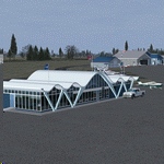
Trois-Rivieres Airport (CYRQ) is located near the city of Trois-Rivieres, Quebec, Canada, midway between Quebec and Montreal on the north shore of the St-Lawrence river. It has a large maintenance and painting shop to service aircrafts the class of B737, A320 or equivalent size. This GA airport had its runway (05-23) extended to 9000' so that is can now receive and accomodate the B767.
This scenery developed in GMax, is an exact and realistic representation of the airport. It features 28 detailed buildings including its unique terminal, custom vehicles and much more. From the airport, you can see the flashing strobe lights of the 1200 feet tower located 8 miles NE of the airport; cleary visible night and day which is a very good landmark coming in to land. Another nice landmark is the nearby beautiful Laviolette bridge (if installed from the same author). Take your favorite GA aircraft there for a sightseeing tour or a fishing trip a short distance north of Trois-Rivieres, your executive jet for a business meeting or service your airline jet in the maintenance bays. It is a nice airport to see.
| Filename: | TroisRivieres_CYRQ.zip |
| License: | Freeware |
| Added: | 26th November 2009, 02:43:30 |
| Downloads: | 7,252 |
| Author: | Gilles Boily |
| Size: | 6.9 MB |
© 2001-2026 AVSIM Online
All Rights Reserved
Privacy Policy |