
Where Flight Simulation Enthusiasts Gather from Around the World!
AVSIM Library - Search Results

| Category: Flight Simulator X - AI Flight Plans | |
| Hong Kong Airlines - Summer 2018 |

|
Images related to this file:
File Description:

Current flight plan of Hong Kong Airlines for summer 2018. Hong Kong Airlines’ growing network currently covers over 30 cities regionally, including the Gold Coast, Auckland, Beijing, Shanghai, Bangkok, Bali, Taipei, Seoul, Tokyo, Sapporo and Okinawa, and the newly launched Vancouver and Los Angeles routes in 2017. The airline has a combined fleet of 35 aircraft. The current passenger fleet has 31 aircraft with an average age of about 5 years as of September 2017.
| Filename: | Hong_Kong_Airlines__Summer_2018.zip |
| License: | Freeware |
| Added: | 17th July 2018, 16:05:37 |
| Downloads: | 295 |
| Author: | Frank Drebing |
| Size: | 20.86 KB |
| Category: Prepar3D V1-4 - AI Flight Plans | |
| Air Mauritius 1998 Flightplans |
|
File Description:
Air Mauritius was operating a pair of ATR-42s and 767-200s as well as several A340-300s in 1998. Though few flights were operated more than once or twice weekly, the airline had a repetitively vast network for it's fleet size, serving points across Africa, several cities in Europe, India, and even Hong Kong. Michael Pearson has painted the whole fleet and is all right here in the Avsim library with further info in the read me.
| Filename: | Air_Mauritius_1998_Flightplans.zip |
| License: | Freeware |
| Added: | 12th August 2019, 17:04:30 |
| Downloads: | 90 |
| Author: | Chasen Richardson\Bayviation |
| Size: | 27.24 KB |
| Category: Flight Simulator 2004 - Scenery | |
| High-resolution 76-m (LOD9) Terrain Mesh and Scenery Enhancements for the Southern Canadian Rockies |
|
File Description:
Not simply an add-on mesh, these files include many scenery enhancements for the southern Rockies of British Columbia and Alberta. Coverage extends from Cranbrook to Calgary, and Hinton to Edmonton (N48.9-53.4 W112.3-116.3). The mesh source data are 3-arcsec (~90-m) Shuttle Radar (SRTM) files, compiled at LOD9 (76-m) resolution. All lake elevations (!) have been adjusted to eliminate the problems with the default lake data and to better fit the new terrain mesh. In addition, the Transcanada Highway/Icefields Parkway corridor in Banff National Park, from Canmore to the Hwy 11 junction, has been completely re-made, with dozens of alpine lakes (including Lake Louise, Moraine Lake, and Lake O'Hara), accurate transportation network, and landclass/waterclass updates based on satellite imagery. Due to significant changes in FS2004 to vector layering and autogen features, the special scenery enhancements cannot be used with FS2002. However, terrain mesh, lake corrections and landclass replacements will work well in FS2002.
| Filename: | Highresolution_76m_LOD9_Terrain_Mesh_and_Scenery_E.zip |
| License: | Freeware, limited distribution |
| Added: | 29th October 2003, 03:01:22 |
| Downloads: | 15,465 |
| Author: | Holger Sandmann |
| Size: | 21.81 MB |
| Category: Flight Simulator X - Scenery | |
| LGSM Samos International Airport, Greece |
|
Images related to this file:
File Description:
LGSM Samos International Airport, Greece.
The island of Samos lies in the Eastern Aegean and is a very popular tourist destination for flights from Berlin, Munich, Gatwick, Oslo, Copenhagen, Rome and many others. It is widely regarded as the most dangerous airport in Greece, mountainous terrain requires a sharp right hand turn onto runway 09 and landings are invariably subject to strong turbulence.
The airport has been designed to sit on the excellent photoreal scenery by Dimitris Ntaskas, which is available here on Avsim and called 'samos_305814.zip'. It also uses many objects from my lgkf_kefallinia.zip scenery also available here at Avsim. The scenery has been designed for and tested with DX9 and FSXA only, if used with the default terrain many objects will be misplaced.
The scenery features a very detailed airport, repositioned according to satellite imagery and is based on real photographs. Full night lighting is included with washed lighting of the apron and carparks. The nearby town of Pythagorio has been modelled and includes some local landmarks. I have included many autogen style buildings based on photographs of Samos and also autogen trees native to the region.
The airport includes many animations, including olive trees, flags, people, windsocks, birds, road traffic and waves. Local Air traffic between the neighbouring islands of Chios, Mykonos, Kos and Rhodes is included, as is a panoramic view from inside the new tower. All the files have been sub-divided and can be switched on or off according to user preference.
Full installation instructions, settings, hints and tips can be found in the readme file. Please enjoy and I hope you like my scenery as much as I enjoyed building it.
| Filename: | LGSM_Samos_International_Airport_Greece.zip |
| License: | Freeware, limited distribution |
| Added: | 27th February 2013, 02:45:01 |
| Downloads: | 23,198 |
| Author: | George Keogh |
| Size: | 47.62 MB |
| Category: Flight Simulator 2004 - Scenery | |
| Kuujjuarapik CYGW in northern Quebec, Canada |
|
Images related to this file:
File Description:
Kuujjuarapik is in northern Quebec at the southern end of Hudson Bay, 90 miles east of James Bay and on the north shore of the Great Whale River; Kuujjuarapik means Small Great River in Inuktitut. Once again the Hudson Bay trading post that opened (in 1820) was the catalyst for the establishment of first a seasonal encampment and then the beginnings of a town in the late 1930's.
The two adjacent villages that now form the town have a total population (mainly Cree and Inuit) of around 1,500. When the Quebec hydo-electric project was under construction in the early 1980's a large portion of the Inuit population voted to move to a new settlement called Umiujaq (my post) 100 miles to the north.
The airport is to the west of the town, between the town and the sea. The gravel and sand runway (which I have made as gravel as there is no convincing way to mix the two) is 5,500 feet long, 150 feet wide, and aligned 17/35, which is approximately parallel to the coast. There is fuel available, both 100LL and JetA, delivered by truck. The AI included here is for Air Inuit and Wasaya, with Air Inuit making three flights per day plus a fourth flight by the Air Inuit Twotter C-GNDO that is based at the airport, and private flights by various aircraft. Yes, there really is a golf course to the south of the airport, and the last thing to note is that Kuujjuarapik has a mandatory radio frequency and that taking into consideration the scheduled flights I have included the tower radio frequency that makes this a controlled airport in FS9.
| Filename: | Kuujjuarapik_CYGW_in_northern_Quebec_Canada.zip |
| License: | Freeware, limited distribution |
| Added: | 16th February 2013, 00:33:20 |
| Downloads: | 306 |
| Author: | Roger Wensley |
| Size: | 2.8 MB |
| Category: Flight Simulator X - Missions | |
| Ft Collins-Loveland Mun to Cheyenne Regional |
|
File Description:
Springtime flying in the Rockies mission. Requires Acceleration pack. This intermediate level mission has three flights to airports in the Rocky Mountains of northern Colorado and southern Wyoming. You'll be busy following waypoints and running through takeoff and landing procedures on these short hops. Weather is from real time conditions in this region around the first of April 2012. The spring weather definitely presents some flying challenges and the snow-capped peaks make for some stunning scenery.
| Filename: | Ft_CollinsLoveland_Mun_to_Cheyenne_Regional.zip |
| License: | Freeware, limited distribution |
| Added: | 2nd July 2012, 08:30:05 |
| Downloads: | 820 |
| Author: | Alan Goodrich |
| Size: | 8.32 MB |
| Category: Flight Simulator X - Scenery | |
| Columbia SC (KCAE) |
|
Images related to this file:
File Description:
The Columbia Metropolitan Airport Authority has provided substantial information about KCAE online, making it possible to pretty accurately model this airport. The taxiway signs have been placed according to exhibits in the airport's certification manual, and taxiway designations have been revised in accordance with upgrades to be effective mid-Novemer 2012. Most buildings have been custom modeled in accordance with information available on the internet, including Microsoft Bing birdseye views. The airport layout and landclass changes are in accordance with Google Earth imagery.
If you have Jim Dhaenens' lightobj.bgl installed, apron lighting will be included, and if you have
KB_static_aircraft_FSX installed (available at www.kb-sim.com/screens_static_aircraft.html),
additional parked aircraft will be visible. The layout of scenery is optimized for use with
Ultimate Terrain X-USA. FSX runs smoothly with this scenery on my computer, but it has not been
tested on a low-end system. Sometime after starting this project, it came to my attention that a
good scenery for KCAE was already available (but not listed at www.freewarescenery.com) from Jim
Hill that is another option as well as adjusting scenery complexity.
The new taxiway designations are not yet shown in the latest observed FAA airport diagram. An airfield sketch provided to pilots by the Columbia Metropolitan Airport is included in the package to show the taxiway designation changes.
| Filename: | Columbia_SC_KCAE.zip |
| License: | Freeware |
| Added: | 14th December 2012, 01:28:23 |
| Downloads: | 1,694 |
| Author: | Art Poole |
| Size: | 3.43 MB |
| Category: Flight Simulator X - Scenery | |
| Mogadishu X, Somalia |
|
Images related to this file:
File Description:
This is Mogadishu International Airport in Somalia. Made from custom created models and textures. It has a photoreal base that changes with the seasons. Completely re designed for FSX with a new AFCAD file,new coastline,roads and landclass. It is a unforgiving country ravished by war. We added some easter eggs in the form of 2 downed Blackhawks in the exact spot that the real Blackhawks went down. See if you can find them. We also added the Olympic hotel with a hard roof for you to land on. The harbour was also modeled and included. FSX Acceleration will give the best results.(Also SP2 compatable). Acceleration users will have more eye candy!Military scenery Objects by Michael Carr.
| Filename: | Mogadishu_X_Somalia.zip |
| License: | Freeware |
| Added: | 25th November 2011, 17:28:23 |
| Downloads: | 3,302 |
| Author: | Frits Beyer, Jacques Botha |
| Size: | 40.29 MB |
| Category: Flight Simulator X - Aircraft Repaints, Textures and Modifications | |
| McDonnell Douglas MD-81/82 Mega Repaint Pack - Western Europe |
|
Images related to this file:
File Description:
This is my Mega Repaint Pack for the CLS McDonnell Douglas MD-81/82. Altogether there are 73 repaints included. In order to make the download easier, I have split the repaints into seven parts, sorted by region. This part contains these repaints from Western Europe: Adria Airways, Alitalia, Austrian Airlines, Blue1, City Airline, Finnair NC, Hello, MeridianaFly, Spanair and Viking Airlines. By Sebastian Szucs
| Filename: | McDonnell_Douglas_MD8182_Mega_Repaint_Pack__Wester.zip |
| License: | Freeware, limited distribution |
| Added: | 22nd February 2011, 02:26:23 |
| Downloads: | 1,701 |
| Author: | Sebastian Szucs |
| Size: | 77.26 MB |
| Category: Flight Simulator X - Aircraft Repaints, Textures and Modifications | |
| Automobile Association (1959 and 1960) de Havilland DH.89A Dragon Rapide (G-AHKV) |
|
Images related to this file:
File Description:
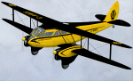
Aircraft repaint for Dave Garwood's de Havilland DH.89A Dragon Rapide Version 4 only. This is my first ever aircraft repaint. Compatibile with Microsoft Flight Simulator X and Lockheed Martin Prepar3D only.
Built in 1944 as NR693, G-AHKV (c/n 6792) served with British European Airways from 1946. By 1954 Sky Neon Aviation were flying the aircraft at night over London with underwing neon advertising signs. Registered to the Automobile Association in 1957, G-AHKV became the most famous of all their aircraft. Flown by former RAF Mosquito pilot Bill Lewis, she was used as a traffic spotter, monitoring congestion and incidents from the air. The prototype of the DH.89A Mk 6 conversion, G-AHKV had sophisticated electrical and navigation equipment on board. She was also an air ambulance, repatriating AA members who had suffered accidents or illness in Europe and dropping supplies to snowbound villages in Scotland. Sold by the AA in 1963, she was burnt at Birmingham Airport in 1969. Two variants of the livery are included.
| Filename: | Automobile_Association_1959_and_1960_de_Havilland_.zip |
| License: | Freeware, limited distribution |
| Added: | 25th November 2012, 17:54:00 |
| Downloads: | 315 |
| Author: | Adrian Petford |
| Size: | 4.1 MB |


© 2001-2026 AVSIM Online
All Rights Reserved
Privacy Policy |