
Where Flight Simulation Enthusiasts Gather from Around the World!
AVSIM Library - Search Results

| Category: Orbiter - Spaceships | |
| Thunderbirds 2, 3 and 5 |

|
File Description:
Take off in Thunderbird2 from Tracy-Island...First Press G to Lower Thunderbird2 onto the POD payload..Then engage 5% thrusters and taxi until the end of the runway..Press B to brake..Press K to raise the Ramp, press CTRL and + on the numpad to engage main thrusters.....Now with Sounds (Needs OrbiterSound ver 2.5 or higher installed)..T2 DLL Based on the Vulcan.dll by David Henderson and the Island Uses Vinkas Spacecraft.DLL(included)...Now includes Thunderbird3 and Thunderbird5.....
| Filename: | Thunderbirds_2_3_and_5.zip |
| License: | Freeware |
| Added: | 16th October 2004, 14:36:57 |
| Downloads: | 723 |
| Author: | Kev Shanow |
| Size: | 1.79 MB |
| Category: Flight Simulator 2002 - Flight Plans | |
| KABQ Departure flight plans |
|
File Description:
These files contain 34 flight plans using coded departure
routes from the Air Traffic Control System Command Center
(ATCSCC). I have modified only the STAR's that were older
than what I have on my Hard Drive dated 3/03.
These plans are for KABQ departures and are included in the
following formats.....
.sbp - For loading into the Squawkbox FMS
.prg - for loading into ACS GPS
.pln - For loading into the FS flight planner (FS2K2)
.fsn - for loading int FSNaigator (ver. 4+)
| Filename: | KABQ_Departure_flight_plans.zip |
| License: | Freeware |
| Added: | 31st May 2003, 16:23:30 |
| Downloads: | 278 |
| Author: | Michael Fox |
| Size: | 76.58 KB |
| Category: Flight Simulator 2004 - Aircraft Repaints, Textures and Modifications | |
| TAC Cessna O-2 |
|
File Description:
USAF O-2 Textures for Mike Stones Cessna O-2 Skymaster
| Filename: | TAC_Cessna_O2.zip |
| License: | Freeware, limited distribution |
| Added: | 2nd September 2004, 18:46:51 |
| Downloads: | 682 |
| Author: | Henry William |
| Size: | 2.35 MB |
| Category: Flight Simulator 2004 - AI Aircraft | |
| Aero Club de Reus GA traffic updates |
|
Images related to this file:
File Description:

Aero Club de Reus HTAI (Henry Tomkiewicz) Cessna variaton (x3), Piper Super Cub PA18 by J.E.Narcizo and Piper PA28 repaints for AI traffic including 'representative' TNG and some charter FlightPlans and an adjusted AF2 for the lovely Simwings "Reus 2005" scenery. This update removes the top wing registration, which seems to be the case with practically all I have seen. I've also included the AFCAD for Reus and also the Aeroclub, which I forgot to upload with the last pack, sorry for that.
| Filename: | Aero_Club_de_Reus_GA_traffic_updates.zip |
| License: | Freeware |
| Added: | 23rd January 2010, 11:07:10 |
| Downloads: | 667 |
| Author: | Billy Rutherford |
| Size: | 3.92 MB |
| Category: Flight Simulator 2004 - AFCAD Files | |
| Los Roques, Venezuela (SVRS) |
|
File Description:
This is an AFCAD2 file for Los Roques in Venezuela to be used with Jaime Ortegas "Los Roques" scenery. With this AFCAD Los Roques is now able
to handle AI traffic also. Los Roques is an archipelago about 30 min. flight north of Caracas. The Los Roques airstrip is situated on the island Gran Roque which seems to be quite a popular tourist spot. Conviasa, LTA (LÃnea TurÃstica Aereotuy), Aeroejecutivos and Sol de America have regular flights to Los
Roques.
| Filename: | Los_Roques_Venezuela_SVRS.zip |
| License: | Freeware, limited distribution |
| Added: | 11th July 2005, 16:16:26 |
| Downloads: | 1,115 |
| Author: | Rene Tanggaard |
| Size: | 80.88 KB |
| Category: Flight Simulator 2004 - Scenery | |
| LPMO Morargil Airfield, Portugal |
|
Images related to this file:
File Description:
LPMO Morargil Airfield.
This is a certified airfield in the neighbourhood of Mora Village (North Alentejo) in the middle south of Portugal, about 4.5 miles SSE from Montargil dam. The house painting respects the traditional Alentejo houses.
This scenery is only compatible with Portugal Terrain from PTSIM (http://www.ptsim.com) and is based on digital pictures taken at the place, accurate real measures by Aerodromos de Portugal (http://www.pelicano.com.pt/zmapa.html) and Google Earth. Freeware. For Microsoft FS2004.NOT tested for FSX
| Filename: | LPMO_Morargil_Airfield_Portugal.zip |
| License: | Freeware |
| Added: | 1st March 2013, 22:39:29 |
| Downloads: | 377 |
| Author: | Joao A. Graca Ferreira |
| Size: | 8.67 MB |
| Category: Flight Simulator 2004 - Scenery | |
| Guatemala & Honduras SRTM Mesh Part 1 |
|
File Description:
This terrain mesh scenery was made to fit Jozef Kusters' Nicaragua mesh on its south-eastern edges. It covers Guatemala, western & northern Honduras (including Isl de la Bahia - Roatan), Belize and Salvador. Based on SRTM Data (3 arc/sec), generated with Matthew Styles's program "SRTM To BGL v1.04", sampled to LOD9 resolution (76m) with 5 interpolation passes. While tested under Fs2004, this mesh should also run in FS2002.
This part contains Guatemala-S.BGL. See guatemala_honduras_mesh_pt1.jpg for .BGL files coverage.
| Filename: | Guatemala__Honduras_SRTM_Mesh_Part_1.zip |
| License: | Freeware |
| Added: | 30th September 2003, 15:19:59 |
| Downloads: | 6,995 |
| Author: | Yohann Baptiste |
| Size: | 16.92 MB |
| Category: Flight Simulator X - Gauges | |
| CB 5000 NAVRAD Navigational RADAR and Multi-Function Display ver 1.5 |
|
Images related to this file:
File Description:
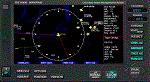
Some of the features included in this gauge are customizable Traffic RADAR, Map Panning, TAWS map, and Nearest Airport Search with a 375 nm range listing up to 500 airports. Instrumentation Manual Included. Come Check Us Out - www.coosbayhops.com
| Filename: | CB_5000_NAVRAD_Navigational_RADAR_and_MultiFunctio.zip |
| License: | Freeware, limited distribution |
| Added: | 20th March 2013, 08:19:09 |
| Downloads: | 2,413 |
| Author: | Greg Swift (CoosBay Hops) |
| Size: | 2.89 MB |
| Category: Flight Simulator 2004 - Scenery | |
| Unlaska (Dutch Harbor) |
|
File Description:
FS2004 Scenery - Unalaska Airport (IATA: DUT, ICAO: PADU, FAA LID: DUT)[2] is a public airport in the City of Unalaska, on Amaknak Island in the Aleutian Islands, off the coast of the U.S. state of Alaska. It is located 50 miles from the Great Circle route to the Orient on the Bering Sea coast of Unalaska Island, 800 air miles southwest of Anchorage and 1,950 miles from Seattle. The usual EZ Scenery Libraries required. By John B. Loney, Jr.
| Filename: | Unlaska_Dutch_Harbor.zip |
| License: | Freeware, limited distribution |
| Added: | 29th November 2007, 10:17:39 |
| Downloads: | 2,335 |
| Author: | John B. Loney, Jr. |
| Size: | 155.83 KB |
| Category: Flight Simulator 2002 - Scenery | |
| Olympic National Park Bush Scenery |
|
File Description:
Ultra-challenging bush scenery set in Washington state's Olympic National Park, just west of Seattle. Consists mainly of small mountain lakes to test the skills of floatplane pilots, but there is also a special sloping airstrip for regular planes. There are 2 groups of scenery included: one on Mount Olympus itself, and the other just a few miles North of Emma Field in the southeast corner of the Park. Requires Steve Greenwood's Olympic National Park/Emma Field mesh (fst-30m10-wa-ef.zip).
| Filename: | Olympic_National_Park_Bush_Scenery.zip |
| License: | Freeware |
| Added: | 28th January 2003, 17:26:26 |
| Downloads: | 1,286 |
| Author: | James Belk |
| Size: | 3.04 MB |


© 2001-2026 AVSIM Online
All Rights Reserved
Privacy Policy |