
Where Flight Simulation Enthusiasts Gather from Around the World!
AVSIM Library - Search Results

| Category: Flight Simulator X - Aircraft Repaints, Textures and Modifications | |
| FSX/P3D Ethiopian Airlines 707-379C 1968 |

|
Images related to this file:
File Description:
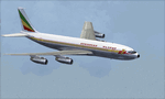
This is a repaint of the 707-379C in Ethiopian Airlines colors. The payware 707-300C by Captain Sim is needed for this repaint. Ethiopian Airlines was established in 1946 by the Emperor Haile Sellassie, and TWA which provided technical and managerial support. Regular operations commenced on April 8 1946 with a fleet of 6 ex USAAF DC-3s. Later in 1950, 2 Convair CV-240s entered the fleet. Then in 1958, the first DC-6B arrived on the scene. On January 1 1959 Ethiopian officially became a member of IATA. The first jet services started in 1963 after the delivery of the carrier's first Boeing 720s. The 720s replaced the DC-6Bs on the European routes. In 1964, Ethiopian started a new pilot training school, installed a large IBM computer system, and also established the largest jet overhaul facility in Africa. 707s, 727s, and 737s, joined the fleet in the ensuing years. Today Ethiopian ranks as Africa's supreme air carrier with a safe and reliable service, notwithstanding the 737 Max 8 tragedy, and has a vast route network. The cherry on top was when in 2014, Ethiopian dethroned South African Airways as the "Best African Airline". Textures are 32 bit dds and DXT5 textures are included as well. This repaint was tested FSX-SE. It should work on FSX & P3Dv1-3.
| Filename: | FSXP3D_Ethiopian_Airlines_707379C_1968.zip |
| License: | Freeware |
| Added: | 20th September 2019, 16:33:20 |
| Downloads: | 131 |
| Author: | Ted Giana |
| Size: | 20.14 MB |
| Category: Flight Simulator X - Scenery | |
| KEFD -Ellington 2025 Refresh FSX (Circa 2006-2010)- Johnson Space Center Houston |
|
Images related to this file:
File Description:

This is a complete refresh in 2025 for the entire Houston Bay Area and KEFD. This is a freeware update for KEFD, published 2025 for FSX, and includes CVX landclass and ADEX.bgl files for KEFD and surrounding greater area, circa 2006-2010. File includes very accurate landclass fixes for the surrounding Bay Area of Houston, and I added tons of VFR scenery objects, featuring Johnson Space Center Houston. Including:
-- Pasadena water treatment facility (Rwy 17)
-- NASA buoyancy lab
-- Pasadena shopping center off of Beltway 8
-- San Jacinto College
-- Pasadena convention center
-- Johnson Space Center Houston
-- Baybrook mall area
-- storage units across from Rwy 35Landclass fixes are extremely accurate, as I used satellite imagery from circa 2006-2010 era. This was both an era when the 147th FW was active, and there was a lot less buildings in the era. -- In addition:
-- I added NASA T38 and F16 parking with ramps
-- Straightened out the very crooked and inaccurate runways and taxis from the other freeware
-- added lighting to KEFD ramps and parking
-- added parking for coast guard MH 65 and helicopter parking for user.
-- Landclass fixes for the barren Spring-cypress greater area (KIAH-KDWH area).I hope you enjoy, north and southeast Houston no longer look like farms and fields with sparce patches of random houses. -DJN
| Filename: | KEFD_Ellington_2025_Refresh_FSX_Circa_20062010_Joh.zip |
| License: | Freeware |
| Added: | 26th May 2025, 23:25:14 |
| Downloads: | 61 |
| Author: | Dan Nelson |
| Size: | 23.49 MB |
| Category: Flight Simulator 2004 - Scenery | |
| Dolbeau-St-Felicien CYDO in Quebec Canada |
|
Images related to this file:
File Description:
This is the fourth of five sceneries around Lac Saint-Jean in Quebec, Canada. Saint-Felicien is a village on a small river at the western end of Lac Saint-Jean, and the airfield is just under 10 miles to the northeast. At the same distance further to the northeast of the airfield and on a slightly larger river is the village called Dolbeau. The village of Sainte-Methode is closer than either of the other villages but presumably lacked influence. The airfield effectively has one runway aligned 11-29 and just under 5,000 feet long, with approach lights on 11. There is, or was, a second runway aligned north-south but this has badly deteriorated without maintenance and has loose stones that threaten propellor damage. The taxiway that runs east-west is in a similar condition and all planes operate as if there is no taxiway. There is a clubhouse and a maintenance facility along with a line of old hangars that remain in full use, plus planes parked in the open. The landclass has been modified along with the grassed area of the airfield, and in the AI (included with the post of CYRC) there are scheduled flights by Max Aviation, and GA flights etc. It is a really typical airfield in northern(ish) rural Canada with a lot more activity than one might expect.
| Filename: | DolbeauStFelicien_CYDO_in_Quebec_Canada.zip |
| License: | Freeware, limited distribution |
| Added: | 19th November 2017, 15:52:32 |
| Downloads: | 167 |
| Author: | Roger Wensley |
| Size: | 4.17 MB |
| Category: Flight Simulator X - AFCAD Files | |
| KOPF - Opa Locka - Miami, Florida 2013 |
|
File Description:
Opa-locka Airport (IATA: OPF, ICAO: KOPF, FAA LID: OPF), also known as Opa-locka Executive Airport, is a general aviation airport and joint civil-military airfield 10 miles (16 km) north of Downtown Miami, primarily in metropolitan
Miami, Florida, United States, with a portion within the city proper of Opa-locka.
The airport's control tower is manned from 7:00 AM to 9:00 PM. The airport has four fixed base operators. It is owned by Miami-Dade County and operated by the Miami-Dade Aviation Department.
The tenant military activity is Coast Guard Air Station Miami, operating HU-25 Guardian jet aircraft, the HC-144 Ocean Sentry[4] turboprop aircraft and HH-65 Dolphin helicopters for coastal patrol and air-sea rescue operations.
Much of CGAS Miami's facilities were originally built during World War II as part of the former Naval Air Station Miami.
DayJet previously provided an on-demand jet air taxi service from this airport to 44 airports in 5 states. The company filed for Chapter 7 bankruptcy liquidation in 2008.
The airport is currently served by several cargo and charter airlines who use the U.S. customs facility. Maintenance and modification of airliners up to Boeing 747 size are carried out by several aviation firms
This file has the right coordenates, apron and characteristics of the airport, airport vehicles and buildings, Airport charts included.
| Filename: | KOPF__Opa_Locka__Miami_Florida_2013.zip |
| License: | Freeware |
| Added: | 6th January 2013, 11:39:28 |
| Downloads: | 770 |
| Author: | anwar gonzalez |
| Size: | 3.96 MB |
| Category: Flight Simulator 2004 - Flight Plans | |
| Flight Through The Grand Canyon |
|
Images related to this file:
File Description:
FS2004 Flight Plan for a flight through the Grand Canyon. If you want some spectacular views and fun flying try out this flight plan. There are over 800 waypoints used that take you through most of the canyon. Two flights included. One going eastbound and the other going westbound. You will be flying in the default Cessna 172 with the autopilot connected. Just sit back and watch the scenery go by. Don't get too relaxed because there are a couple of turns that you will have to take control of the aircraft. Included in this package is a gauges by Karol Chlebowski for TFR flying which enhance the sight seeing experience. Another option to download Version 2.0 of FS2004 my mini panel which has all this functionality included and more.
| Filename: | Flight_Through_The_Grand_Canyon.zip |
| License: | Freeware |
| Added: | 17th July 2011, 01:54:59 |
| Downloads: | 285 |
| Author: | Bill McClellan |
| Size: | 1.86 MB |
| Category: Flight Simulator 2004 - Scenery | |
| Fort Resolution CYFR in the Northwest Territories, Canada |
|
Images related to this file:
File Description:
Fort Resolution is on the south side of Great Slave Lake, 75 miles east of Hay River and just west of where the Slave River flows into the lake from Fort Smith. Fort Resolution, the oldest community in the Territories and once a vital link in the fur trade business, is a small town with a population of around 500. It was not included in the original FS9 or Ultimate Terrain so I have added it here.
The airfield is next to the town on the lakeshore. The runway is 4,000 feet of gravel with a displaced threshold at the southern (town) end; it is lit and there is PAPI. There are no scheduled flights to Fort Resolution, just occasional charters; the AI includes a stock FS9 Cessna and a Wasaya Airways PC12.
| Filename: | Fort_Resolution_CYFR_in_the_Northwest_Territories_.zip |
| License: | Freeware, limited distribution |
| Added: | 4th October 2013, 22:11:26 |
| Downloads: | 294 |
| Author: | Roger Wensley |
| Size: | 2.31 MB |
| Category: Flight Simulator 2004 - Scenery | |
| Custer Airport, KTTF, Monroe, MI |
|
Images related to this file:
File Description:
FS2004 Scenery - Custer Airport (ICAO: KTTF, FAA LID: TTF), sometimes referred to as Monroe Custer Airport, is a city-owned public airport located in the city of Monroe in Monroe County, Michigan. The airport opened in November 1946 and was named for George Armstrong Custer, who spent much of his early life in Monroe. Custer Airport is able to accommodate a large variety of aircraft, including single engine aircraft, twin engine aircraft, and business jets such as the Cessna Citation and Learjet. The airport has personal hangars that house approximately 45 airplanes and a large hangar that houses several corporate aircraft as well as the Monroe Aviation School of Flight and Monroe Aviation Aircraft Maintenance. Created using Instant Scenery 2. AI Aircraft included. By John B. Loney, Jr.
| Filename: | Custer_Airport_KTTF_Monroe_MI.zip |
| License: | Freeware, limited distribution |
| Added: | 13th July 2010, 02:50:52 |
| Downloads: | 453 |
| Author: | John B. Loney, Jr. |
| Size: | 5.6 MB |
| Category: Flight Simulator 2004 - Panels | |
| Display My Favorite Picture |
|
File Description:
MyPix Panel addon. Have you been flying so long that you have forgotton what your wife, husband, girfriend, significant other or mother-in-law looks like? This little panel addition allows you to display your favorite picture (.bmp format) by clicking on a panel icon. This can be added to virtually any panel - setups for the default b737-400 and Cessna 172sp are included. This can be used to display any .bmp formatted picture so in addition to your favorite pin-up, a chart or runway layout could be displayed - the possibilities are limited only by your imagination. Unzip to a temporary folder (use folders option checked) and follow the install instructions. Compiled by David Marshall, Plano, Texas. Note: I am not responsible for how you fly if your mother-in-law's picture is displayed!
| Filename: | Display_My_Favorite_Picture.zip |
| License: | Freeware |
| Added: | 15th November 2004, 14:01:14 |
| Downloads: | 1,213 |
| Author: | David Marshall |
| Size: | 1.53 MB |
| Category: Flight Simulator 2004 - AI Flight Plans | |
| Default AI General Aviation V2 |
|
File Description:
These files are the default AI flight plans for all the general aviation flights as delivered in Flight Simulator 2004. They have been separated by aircraft and sorted by departure region/country.
These flightplans may be used as a basis for more realistic GA traffic. From replacing the tail numbers with realistic regionally accurate numbers to completely replacing the default flights with more realistic AI GA traffic on a regional basis. These files will also make it easier to shift GA traffic out of major commercial hub airports (so you won't be running over a Cessna 172 while on final approach into JFK any more).
This second version is to correct the Beech King Air 350 (AC#2). In the first version all the flight plans had somehow been doubled in the file.
| Filename: | Default_AI_General_Aviation_V2.zip |
| License: | Freeware |
| Added: | 9th January 2005, 17:53:58 |
| Downloads: | 3,608 |
| Author: | James Whitaker |
| Size: | 728.1 KB |
| Category: Flight Simulator X - Scenery | |
| Custer Airport, KTTF, Monroe, MI |
|
Images related to this file:
File Description:
FSX Scenery - Custer Airport (ICAO: KTTF, FAA LID: TTF), sometimes referred to as Monroe Custer Airport, is a city-owned public airport located in the city of Monroe in Monroe County, Michigan. The airport opened in November 1946 and was named for George Armstrong Custer, who spent much of his early life in Monroe. Custer Airport is able to accommodate a large variety of aircraft, including single engine aircraft, twin engine aircraft, and business jets such as the Cessna Citation and Learjet. The airport has personal hangars that house approximately 45 airplanes and a large hangar that houses several corporate aircraft as well as the Monroe Aviation School of Flight and Monroe Aviation Aircraft Maintenance. Created using Instant Scenery 2. AI Aircraft included. By John B. Loney, Jr.
| Filename: | Custer_Airport_KTTF_Monroe_MI.zip |
| License: | Freeware, limited distribution |
| Added: | 13th July 2010, 02:51:45 |
| Downloads: | 669 |
| Author: | John B. Loney, Jr. |
| Size: | 5.61 MB |


© 2001-2026 AVSIM Online
All Rights Reserved
Privacy Policy |