
Where Flight Simulation Enthusiasts Gather from Around the World!
AVSIM Library - Search Results

| Category: Flight Simulator X - Scenery | |
| channel ships |

|
File Description:
Ships, loads of ships in the English Channel (excusee: Pas de Calais)
About 60 ships (apart from ai ships)
When flying over the Channel, pilots say that an emergency landing here would certainly mean a crash into a ship; there are that many ships about.
You'll see Cargo ships, containerships, super tankers. Cruisliners are symbolic for the ferries sailing to and from Calais / Dover and Dunkirk.
Corrected for use with Ultimate terrain Europe
To be able to see this scenery I had to make a fake airport and named it LF00 (read: LF zero-zero)
There's a tower position as well, midways the channel with a height of 100 mtr. I haven’t tested it, it's not visible either.LF00 is visible in your GPS. Have fun.
| Filename: | channel_ships.zip |
| License: | Freeware, limited distribution |
| Added: | 12th January 2009, 13:00:36 |
| Downloads: | 3,771 |
| Author: | Joost Visser / ade1.37 |
| Size: | 134.43 KB |
| Category: Flight Simulator 2004 - Scenery | |
| Cavanaugh Bay 66S Idaho Airport |
|
File Description:
Priest Lake in Idaho is described by their Chamber of Commerce as "...a magnificent 23,000 acre azure lake nestled beneath the majestic Selkirk Mountains — without question, one of the most beautiful wilderness areas you’ll ever see." Cavanaugh Bay is a grass strip right on the lake, with lodges (there's one right next to the end of the runway), campgrounds and boat/plane docks nearby. I think I was able to make a fair approximation of the real thing, based on Google Earth. If you're flying something that floats, choosing RWY S or RWY E from the FS9 airport menu will park you conveniently at a floatplane dock. This scenery was designed for use with Ultimate Terrain USA and has not been tested with the default FS9 scenery.
| Filename: | Cavanaugh_Bay_66S_Idaho_Airport.zip |
| License: | Freeware |
| Added: | 14th July 2008, 13:38:40 |
| Downloads: | 608 |
| Author: | Sidney Schwartz |
| Size: | 654.43 KB |
| Category: Flight Simulator 2004 - Scenery | |
| Pinal Airpark KMZJ |
|
File Description:
FS2004 Scenery - Pinal Airpark (IATA: MZJ, ICAO: KMZJ) is an airport located in Pinal County, seven miles (11 km) northwest of the central business district (CBD) of Marana, a city in Pima County, Arizona, USA. Its main purpose is to act as a "boneyard" for aircraft. Old airplanes are stored there with the hope that the dry desert climate will prevent rust and other forms of corrosion in case the aircraft is pressed into service in the future. Even so, many aircraft which are brought there wind up being scrapped. Nearby Davis-Monthan Air Force Base provides the same service to the U.S. military. Compatible with both FS default and Ultimate Terrain. EZ Scenery Libraries required. Some included. by JOhn B. Loney, Jr.
| Filename: | Pinal_Airpark_KMZJ.zip |
| License: | Freeware, limited distribution |
| Added: | 16th March 2008, 05:46:41 |
| Downloads: | 1,621 |
| Author: | John B. Loney, Jr. |
| Size: | 7.14 MB |
| Category: Flight Simulator 2004 - Scenery | |
| Portland KPDX Scenery Enhancement |
|
File Description:
Re-upload. The default FS9 KPDX scenery is not bad, but it's out of date and lacks jetways. I didn't set out to recreate KPDX in detail, just to make the terminal building more accurate. This enhancement has the following features:
1. A new terminal building and parking structure are now accurately sized and placed.
2. The control tower was moved to its correct position.
3. The correct number of jetways has been added.
4. Ramp lighting has been added.
5. Some inaccuracies in the aprons and taxiways have been fixed.
6. The misaligned ILS for runway 28L has been corrected.
7. The afcad has been redone. If you are using Ultimate Traffic you should see more accurate AI traffic parking.
| Filename: | Portland_KPDX_Scenery_Enhancement.zip |
| License: | Freeware |
| Added: | 21st June 2010, 11:09:47 |
| Downloads: | 4,325 |
| Author: | Sidney Schwartz |
| Size: | 1.19 MB |
| Category: Flight Simulator 2004 - Scenery | |
| Southern California Oilrigs v2.0 |
|
File Description:
This is a revised version of my previous rendition of the Oil Rigs off the Southern California Coastline. This file acurately represents the positions of ALL of the Oilrigs extending from Lompoc to Newport Beach, California. Also included are 4 lighthouses not placed in the FS2004 Default Scenery located from Morro Bay - Point Conception, California. * * REQUIRES RWY 12 * * This add-on was created with Runway 12 add-on, so you must have this add-on installed, or at least the scenery BGL and Texture files installed in your Addon Scenery\Static Objects Library folder for the scenery to work. In addition, the scenery was created while using Ultimate Terrain USA, so default FS2004 Scenery users may have some scenery items in slightly different places.
| Filename: | Southern_California_Oilrigs_v20.zip |
| License: | Freeware |
| Added: | 24th September 2005, 18:43:11 |
| Downloads: | 1,327 |
| Author: | Brian C. Selb |
| Size: | 63.56 KB |
| Category: Flight Simulator X - Scenery | |
| F45 - North Palm Beach County General Aviation Airport - West Palm Beach, Florida (USA) |
|
Images related to this file:
File Description:
North Palm Beach County Airport, located northwest of West Palm Beach, Florida, was opened in 1994 as a designated reliever for KPBI. All of the buildings have been custom modeled in accordance with information available on the internet including Microsoft Bing birdseye views. The airport layout and landclass changes are in accordance with Google Earth imagery.
If you have Jim Dhaenens' lightobj.bgl installed, apron lighting will be included, and if you have KB_static_aircraft_FSX installed (available at www.kb-sim.com/screens_static_aircraft.html), additional parked aircraft will be visible.
The layout of scenery is optimized for use with Ultimate Terrain X-USA. There is no FAA airport diagram for this airport, but a taxiway diagram provided by the local Airport Authority is included in this package.
| Filename: | F45__North_Palm_Beach_County_General_Aviation_Airp.zip |
| License: | Freeware |
| Added: | 22nd August 2013, 20:48:03 |
| Downloads: | 1,151 |
| Author: | Art Poole |
| Size: | 1.27 MB |
| Category: Flight Simulator X - Scenery | |
| CZBB - Boundary Bay, BC, Canada (2011) Version 2 |
|
Images related to this file:
File Description:
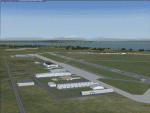
CZBB (2011) portrays the Boundary Bay (British Columbia, Canada) Airport (CZBB) - Canada's fifth-busiest airport by number of operations - and surrounding area as it appeared in mid-2011. Every significant structure on the airfield (50+) is included - all modeled with GMax and painted with hand-drawn textures. CZBB (2011) is compatible with ORBX FTX USA Canada Pacific Northwest, Ultimate Terrain and Vancouver+. A selection of SAMM-generated static aircraft are scattered around the aprons supplemented by a number of AI aircraft that do touch 'n gos from time to time.
Aside from the new custom approach and airfield lighting, generally, this new version is visually identical to its predecessor - even though quite different internally. As well, to the extent possible, it is compatible with Prepar3Dv2.
| Filename: | CZBB__Boundary_Bay_BC_Canada_2011_Version_2.zip |
| License: | Freeware, limited distribution |
| Added: | 20th June 2014, 05:10:24 |
| Downloads: | 3,487 |
| Author: | Don Grovestine |
| Size: | 73.9 MB |
| Category: Flight Simulator X - AFCAD Files | |
| Cross Keys Airport (17N), NJ |
|
File Description:
Located 01 miles S of Cross Keys, New Jersey on 280 acres of land, Cross Keys Airport is a small General Aviation field privately owned by Cross Keys Airport Inc. In addition to servicing GA flights, the airport also hosts a paintball field and a sky diving operation to the north of the field. For this reason, all aircraft must remain south of the runway at all times. Any aircraft with a wingspan larger than 40 feet will need to park in the turf area west of the main apron - smaller GA aircraft can pick a spot from any of the open tiedown areas. 100LL (Blue) Fuel is available by stopping next to the fuel tank on the main apron. Although it doesn't exist in real life, a patch of concrete to the west of the main apron made for a good helipad, so I included one. It is not lit at night. Trees in the surrounding forest are summer trees ONLY.
Scenery constructed with use of Google Maps images, and vague recollection by the author who went sky diving there once.
This scenery is meant to be used in conjunction with MegaScenery Earth New Jersey/Delaware 004. It is not required, but apron use is minimized to allow satellite scenery to show through as much as possible, and objects are placed based on the MSE textures - lack of it may make scenery look out of place.
| Filename: | Cross_Keys_Airport_17N_NJ.zip |
| License: | Freeware |
| Added: | 7th October 2010, 03:27:53 |
| Downloads: | 246 |
| Author: | Drew Sikora |
| Size: | 719.13 KB |
| Category: Flight Simulator X - Scenery | |
| Kopaida Airfield, Greece |
|
Images related to this file:
File Description:
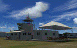
"Kopaida" airfield is a grass private strip, 105km NW of Athens located in the Kopaida drained lake plains between the towns of Aliartos, Kastro and Orchomenos and west of Yliki lake. It is a pure general aviation field and a hub of activity for numerous sport planes, gliders and motor gliders. The field includes a small tower and canteen and several owners of GA aircraft house them in the roomy hangar and also keep a mobile home or RV in the premises. The scenery includes a region and landclass bgl that will force a large area of the Kopaida plains around the airport to display US field textures. This was done because the US fields textures are rectangular and aligned N-E and W-E, in a similar way as the actual fields around the airport. A small photo background is used for the airfield itself. The photo background includes seasonal variations with slight colour variances as well as some autogen trees and shrubs. Custom GA traffic is also included. There is one trike doing circuits and TnGs and a Turbo Porter flying the circuit, simulating a skydiving sortie. The Turbo Porter used is the great freeware one created by Tim (Piglet) Conrad. I have also included a repaint for the F-GHVH, the Porter used by the GFFC, which sports a flashy "Alien" graffiti scheme.
*For FSX SP2 / Acceleration / P3D v1.00*
| Filename: | Kopaida_Airfield_Greece.zip |
| License: | Freeware |
| Added: | 3rd June 2014, 21:23:30 |
| Downloads: | 1,472 |
| Author: | Vassilios Dimoulas |
| Size: | 25.01 MB |
| Category: Flight Simulator 2004 - Panels | |
| FS2004 Glass Cockpit Mini Panel |
|
Images related to this file:
File Description:
FS2004 Glass Cockpit Mini Panel that many of you requested is intended to replace the global default minipanel or my previous analog mini panel. The mini panel is made up of mostly Glass Cockpit LCD instruments. This gives the pilot a common set of LCD type gauges to use on multiple aircraft. Many pop-up windows available to keep the main mini panel uncluttered. Additional navigation and control surfaces gauges are provided. Information is provided for wind direction, drift, ETA, ETE, direction, distance and information on the nearest airport; direction and distance to the next waypoint set in the GPS; and radar/absolute altitude. Lee Hetherington excellent TCAS gauge is also available. Karol Chlebowski�s TFR gauge is included that allow flight at extremely low altitudes. Extensive tooltips have been provided on most gauges.
| Filename: | FS2004_Glass_Cockpit_Mini_Panel.zip |
| License: | Freeware |
| Added: | 21st September 2010, 21:40:15 |
| Downloads: | 685 |
| Author: | Bill McClellan |
| Size: | 5.17 MB |


© 2001-2026 AVSIM Online
All Rights Reserved
Privacy Policy |