
Where Flight Simulation Enthusiasts Gather from Around the World!
AVSIM Library - Search Results

| Category: Microsoft Flight Simulator (2020) - Aircraft Repaints, Textures and Modifications | |
| Bleriot XI F-AZPG |

|
Images related to this file:
File Description:
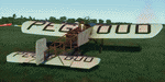
This folder contains a repaint for the Bleriot XI by Wings42 in the colors of Bleriot XI-2 F-AZPG, a replica Bleriot XI, based with the Amicale Jean-Baptiste Salis in La Ferte Alias in France. Adolphe Pégoud, whose name is on the wings, was a French pilot and flight instructor who became the first fighter ace in WW1. He was the first pilot to make a parachute jump from an airplane, and was the second pilot to fly a loop. He died when he was shot down by one of his prewar German students on 31 August 1915 at the age of 26. Repaint by Jan Kees Blom
| Filename: | Bleriot_XI_FAZPG.zip |
| License: | Freeware |
| Added: | 8th May 2021, 17:40:05 |
| Downloads: | 12 |
| Author: | Jan Kees Blom |
| Size: | 39.81 MB |
| Category: Flight Simulator X - Scenery | |
| DAAT - Aguenar / Hadj Bey Akhamok Airport - Tamanrasset, Algeria |
|
File Description:
Aguenar - Hadj Bey Akhamok Airport (French: Aeroport de Tamanrasset / Aguenar - Hadj Bey Akhamok) (IATA: TMR, ICAO: DAAT), also known as Aguenar Airport or Tamanrasset Airport, is an airport serving Tamanrasset, a city in the Tamanrasset Province of southern Algeria. It is located 3.6 nautical miles (6.7 km) northwest of the city. The airport was an alternative landing site for NASA's Space Shuttle, and have been used for American military operations.
In the mid-2000s it was extensively upgraded to serve additionally as a military base, with 10 hardened aircraft shelters, aprons, personnel accommodation and other facilities. Please note that runway 08-26 and ILS are out of service at this time. This work is dedicated to West Wind Airlines.
| Filename: | DAAT__Aguenar__Hadj_Bey_Akhamok_Airport__Tamanrass.zip |
| License: | Freeware |
| Added: | 21st April 2013, 22:09:29 |
| Downloads: | 2,115 |
| Author: | Anwar Gonzalez |
| Size: | 7.17 MB |
| Category: Flight Simulator X - Scenery | |
| Vietnam War project - base pack |
|
Images related to this file:
File Description:
FSX Vietnam War Project - base pack version 0.9. FSX SP1/SP2 needed - Acceleration Pack optionnal, recommended.
About 100 new and redone airfields from SEA (Cam Ranh, Bien Hoa, Phu Cat, Nakhon Phanom, Korat...). French and English documentation (50 pages). Requires Vietnam War project AI airplanes (VnW_AI.zip).
TAD for each airfield. Additional sceneries. 25 flight plans to help you flying over the area.
Included : Al Simms Vietnam war objects, Jim Dhaenens Radars, lights and shelters, Guy Diotte static airplanes.
2 Objects libraries needed : read the quick installation guide.
Visit the project web site : http://vietnamwar.project.free.fr/
To contact us : [email protected]
FSX Vietnam War project: Jacques Godfrin - Xavier Carre
| Filename: | Vietnam_War_project__base_pack.zip |
| License: | Freeware, limited distribution |
| Added: | 11th April 2010, 07:57:17 |
| Downloads: | 2,047 |
| Author: | Jacques Godfrin, Xavier Carre, Vietnam War project |
| Size: | 76.47 MB |
| Category: Flight Simulator 2004 - Flight Plans | |
| TEAL - the Coral Route - 1952 |
|
File Description:
TEAL introduced this service in 1951, ferrying passengers, mail and small freight items between Auckland (NZ), Suva (Fiji), Faleolo (Samoa), Motu Akaiami (Cook Islands) and Papeete (Tahiti, French Polynesia).
Service was initially monthly but after six months became fortnightly as its appeal spread world-wide. After all, who wouldn’t like to spend a holiday in a tropical paradise, conveyed to your destination aboard a flying boat, landing in tranquil lagoons fringed by white sandy beaches and palm trees?
Now you can relive those idyllic times by flying your Short Solent IV from Auckland to Tahiti in early May, 1952.
Please read the enclosed INSTALL.txt first and and coral52.doc files for essential information.
| Filename: | TEAL__the_Coral_Route__1952.zip |
| License: | Freeware |
| Added: | 4th January 2006, 14:40:37 |
| Downloads: | 691 |
| Author: | Bruce Kennewell |
| Size: | 70.23 KB |
| Category: Flight Simulator 2004 - Panels | |
| Fouga Magister alternative 2D rear seat panel "periscopal" view |
|
File Description:
This is an alternative 2D rear seat panel for the magnificent Fouga Magister by A. Chancel, J-P Langer, J-P Bourgeois, B. Dube and M. Hardouin which can be downloaded from http://restauravia.com. The aircraft is a true "must" for any FS addict and comes complete with a thorough documentation both in French and in English. It includes some very novel features, among which the possibility to "fly" the aircraft from the rear seat both with a conventional 3D view and with a so-called "periscopal" 2D view, just like in the real aircraft. This alternative "periscopal" view includes all the necessary instruments to land the aircraft from the rear seat. Happy flights!
| Filename: | Fouga_Magister_alternative_2D_rear_seat_panel_peri.zip |
| License: | Freeware |
| Added: | 17th May 2007, 00:56:06 |
| Downloads: | 561 |
| Author: | Michel Gerard |
| Size: | 183.76 KB |
| Category: Flight Simulator 2004 - Aircraft Repaints, Textures and Modifications | |
| "Prytanee National Militaire" Beechcraft Twin Bonanza" |
|
File Description:
To my French Simmers.
This repaint is by request.This theme was not know before I met Bernard.In return for his help for which I'm very greatful this seems the very least I could do for him!This repaint is dedicated not only to Bernard but to all the students and graduates of Le Prytanée National Militaire de Fleche. I hope this repaint expands my work to other nationalities. My only regret is that I only speak,read and understand English.
This files includes the following folders.The Texture.Prytanée, the Texture.Militaire,the panel.Prytanée and the panel.Militaire.
"IMPORTANT"!!!.......The following additional file is required.--------------twinstar__twin__bonanza_v2.zip--------------
This file includes a complete matching interior for both liveries".
| Filename: | Prytanee_National_Militaire_Beechcraft_Twin_Bonanz.zip |
| License: | Freeware |
| Added: | 25th July 2008, 17:05:50 |
| Downloads: | 1,606 |
| Author: | Chris Tuinstra |
| Size: | 7.16 MB |
| Category: Flight Simulator X - Scenery | |
| LFLB |
|
File Description:
Adjusted scenery for FSX
Uploaded to AVSIM only.
1 rearranged gates and parking spots (as seen on pictures)
(Small disadvantage is that FS places a Pushback car at the end, may be changed in an other version)
2 birds SW and NW of the runway and high flying Eagles in the mountains left and right of the airport.
3 an NDB transmitter where the NDB is south of the runway.
4 rearranged buildings at the airport and some privat planes on the parkings
5 An MD83 on the apron.
6 small (if any) impact on frame rates.
Overall: a more lively LFLB, Aix Les Bains in the French Alps
Have fun and have many good flights in 2009!
| Filename: | LFLB.zip |
| License: | Freeware, limited distribution |
| Added: | 5th January 2009, 13:25:03 |
| Downloads: | 1,057 |
| Author: | Joost Visser thanks to ADE |
| Size: | 164.54 KB |
| Category: Flight Simulator X - Scenery | |
| Paris Le Bourget LFPB France |
|
Images related to this file:
File Description:
Scenery of a famous French airport Le Bourget, the home of a well-known air show. It is located 12 kilometers southeast of Paris and primarily used by business jets (but can easily accomodate A380 or large cargo planes). Due to close proximity of Charles de Gaulle international airport, Le Bourget has unusual approach to runway 25 to avoid de Gaulle traffic. Oh, and you can see the Eiffel Tower from here! This scenery has super-accurate layout, taxiways, markings and navaids according to the latest charts (May 2017; included) and satellite images. Made for P3Dv3, but works fine in FSX:SE and should work in vanilla FSX and P3Dv4 too. Made by Dmitriy Kozyrev.
| Filename: | Paris_Le_Bourget_LFPB_France.zip |
| License: | Freeware |
| Added: | 8th September 2017, 17:52:01 |
| Downloads: | 4,526 |
| Author: | Dmitriy Kozyrev |
| Size: | 5.31 MB |
| Category: Flight Simulator X - Aircraft Repaints, Textures and Modifications | |
| Air Inter Airbus A300 B4 Circa 1986 |
|
Images related to this file:
File Description:
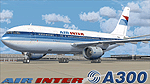
Air Inter Airbus A300 B4 for Thomas Ruth's A300 model. Air Inter was the domestic French carrier from the late 50's to the late 90's. By 1997, it was fully integrated into Air France. During its history, Air Inter operated many aircraft types, including the Caravelle 3 and 12, the Dassault Mercure 100, the Airbus A300 and A320/321/330, the Fokker 27/100, the Vickers Viscount, the Douglas DC-3, and a few other. They even operated the 747-100 for a year in the late 80's.
The Airbus A300 was the backbone of the fleet in the 80's.
These are texture only, you'll need the original model: tom30b.zip
| Filename: | Air_Inter_Airbus_A300_B4_Circa_1986.zip |
| License: | Freeware, limited distribution |
| Added: | 5th October 2010, 00:35:10 |
| Downloads: | 1,738 |
| Author: | Thomas Lo Gerfo ; Thomas Ruth |
| Size: | 2.56 MB |
| Category: Flight Simulator 2004 - Scenery | |
| KJIF Jacksonville Imeson Airport Retro scenery |
|
File Description:
*** This is an updated version with fixes and instructions for locating some of the ai aircraft needed.***
Imeson Field, as it was also known, has been long closed down and replaced by the Jacksonville International airport (KJAX) in 1968. This scenery will bring back Imeson Field (and remove KJAX) to its glory days of the 1950s and 1960s with traffic files to match. Dan French has provided custom terminals, hangars and buildings for this project and Deltadart has provided many custom Military aircraft textures covering the many aircraft types employeed by the 159th FIS Forida Air National Guard during this period. This scenery is meant to work with the Calclassic retro environment by Tom Gibson and the Calclassic community.
| Filename: | KJIF_Jacksonville_Imeson_Airport_Retro_scenery.zip |
| License: | Freeware |
| Added: | 9th April 2023, 18:56:18 |
| Downloads: | 80 |
| Author: | Al Von Pingel |
| Size: | 22.44 MB |


© 2001-2026 AVSIM Online
All Rights Reserved
Privacy Policy |