
Where Flight Simulation Enthusiasts Gather from Around the World!
AVSIM Library - Search Results

| Category: Flight Simulator 2004 - Scenery | |
| Tuktoyaktuk CYUB in Northwest Territories, Canada |

|
Images related to this file:
File Description:
Tuktoyaktuk is on the northern coast of Canada, 70 miles north of Inuvik and to the east of the Mackenzie River delta. It has a population of around 900 and because of its natural harbour is a centre for oil exploration activity on the surrounding land and on the Beaufort Sea, with sizeable but now under-used yards dating back to the peak of activity in the late 1970's. On land work is restricted to the winter half of the year, as only the freeze-up makes it possible to move on land with heavy equipment, and during the winter further supples are driven over an ice road from Inuvik up to Tuk. The ice-free summer months are used for floating equipment from Yuk along the coast on barges and then up the rivers to inland sites in preparation for the winter activity. Before the oil there was a DEW line station here, and there is still an automated station on the same site and included here, as are the yards. The airfield is on the coast close to the town and the yards, at 15' ASL. The gravel runway 09/27 is 5,000' feet long and 150' wide; both thresholds are displaced by 200', but of course there are no markings on the gravel. The large apron is on the north side at the centre of the runway and is large enough to accomodate several large planes. Inuvik revised should be installed first, now Tuk, then last of the three Sachs Harbour which has AI for Aklak Airlines flights (operated by Kenn Borek) for all three airfields. There is a separate AI file included here, featuring freight delivery by Buffalo Airways and small planes.
| Filename: | Tuktoyaktuk_CYUB_in_Northwest_Territories_Canada.zip |
| License: | Freeware, limited distribution |
| Added: | 14th May 2012, 17:19:20 |
| Downloads: | 618 |
| Author: | Roger Wensley |
| Size: | 8.99 MB |
| Category: Flight Simulator 2004 - Scenery | |
| Cape Dyer CWFD in Nunavut, Canada |
|
Images related to this file:
File Description:
Cape Dyer is on the southeast corner of Baffin Island, around 120 miles east of Pangnirtung at approximately N66 45 W61 30. There is a fine view north up the Davis Strait between Baffin Island and Greenland, and this is the whole reason for the airfield's existance as it was built to support the construction and operation of a DEW line radar station, which has now been updated to a North Warning System site. There are two camps; the upper camp is on the east side of the Cape and is where the radars are located, linked by a gravel road to the lower camp, which is on the west and more sheltered side of the Cape on the clifs above Sunneshine Fjord. The runway is 5,000' of 150' wide gravel, and it is lighted and at 1,320' feet ASL. Cape Dyer is now listed as abandoned in the Canada Flight Supplement. It is, however, still there and presumably is still used for access to the North Warning System equipment, which is automated and generally unmanned. The buildings were modeled for this scenery and include a hanagar large enough to accommodate a C-130. Ultimate Terrain is not required as it does not cover northern Canada.
| Filename: | Cape_Dyer_CWFD_in_Nunavut_Canada.zip |
| License: | Freeware, limited distribution |
| Added: | 21st June 2011, 19:30:07 |
| Downloads: | 488 |
| Author: | Roger Wensley |
| Size: | 1.9 MB |
| Category: Flight Simulator 2004 - Scenery | |
| Umiujaq CYMU in Northern Quebec, Canada |
|
Images related to this file:
File Description:
Umiujaq is a small village on the east coast of Hudson Bay, in Quebec, around 140 miles south of Inukjuak and 100 miles north of Kuujjuarapik; the latter is where some 500 inhabitants moved from in 1986 to avoid the effects of a hydroelectric dam project and founded Umiujaq. The airfield is a mile and a half inland and southeast of the village, and the 3,520 feet of gravel runway is aligned 03/21, and these are magnetic bearings as Inukjuak is not in the Northern Domestic Airspace zone. There is no fuel available, unless there is some 100LL in drums. The visiting AI airline is Air Inuit from Montreal.
| Filename: | Umiujaq_CYMU_in_Northern_Quebec_Canada.zip |
| License: | Freeware, limited distribution |
| Added: | 22nd December 2011, 01:00:20 |
| Downloads: | 632 |
| Author: | Roger Wensley |
| Size: | 1.95 MB |
| Category: Flight Simulator 2004 - Scenery | |
| 13 Northern Ontario Airfields in Canada |
|
Images related to this file:
File Description:
These are 13 airfields in northwest Ontario, Canada. They were previously posted individually, but not on Avsim. There is a screenshot of Google Earth showing their names and locations. There are also updates to two previously posted airports, Red Lake CYRL and Sioux Lookout CYXL, and AI with the supply flights that are vital for these isolated outposts. Pickle Lake is a northern airfield that is connected to the rest of Canada by an all-weather road, and a large number of the supply flights originate from there. In fact these flights are the primary reason for the small towns existence. This will be followed by a posting of a similar number of northern Manitoba airfields. You may wonder about the numbers of fuel tanks at these airfields. These are not for the airfield use, they are for the settlement to be able to generate electricity and also to provide heating in the winter. If you find an error email me please, and note that my email address has been changed to rogwens at Gmail dot com.
| Filename: | 13_Northern_Ontario_Airfields_in_Canada.zip |
| License: | Freeware, limited distribution |
| Added: | 6th April 2021, 18:03:40 |
| Downloads: | 160 |
| Author: | Roger Wensley |
| Size: | 43.84 MB |
| Category: Flight Simulator 2004 - Scenery | |
| Hat Island CWHI in Nunavut, Canada |
|
Images related to this file:
File Description:
This was a DEW line I Station on Hat Island; the island is around 4 miles square and just under 50 miles southeast of Jenny Lind Island. The station was closed in 1963 and has now been totally dismantled and removed, a fairly easy task given the size. The runway is still there and is a shade over 3,000 feet of gravel 100' wide. There are no lights, signage, or windsock. A North Warning System station was built in 1991 on the site of the I Station, just north of the runway. Most of these DEW line stations are not particularly impressive or even interesting. However, you can bet that any pilot flying regularly in the north along the coast knows where all these runways are, in case one of them suddenly becomes his favourite in the whole world just after the sudden silence.
| Filename: | Hat_Island_CWHI_in_Nunavut_Canada.zip |
| License: | Freeware, limited distribution |
| Added: | 15th November 2012, 13:55:41 |
| Downloads: | 195 |
| Author: | Roger Wensley |
| Size: | 1.08 MB |
| Category: Flight Simulator 2004 - Scenery | |
| Coral Harbour CYZS in Nunavut, Canada |
|
Images related to this file:
File Description:
Coral Harbour is on Southampton Island, which partly blocks the northern end of Hudson Bay and is around the size of Switzerland. The village has a population of just under 800 people and is some 200 miles from Cape Dorset, Ivujivik, and Repulse Bay, and 230 miles from Chesterfield Inlet to the southwest. Cape Dorset and Ivujivik have already been posted and Chesterfield Inlet will be posted later this month. The airfield is inland from the village and the 5,000 feet of gravel runway is aligned 155T/335T where T stands for "true" as opposed to magnetic in the Northern Domestic Airspace. JETA-1 fuel is officially available, and in practice so is 100LL, though the latter will be in drums. The visiting AI airlines are First Air and Calm Air.
| Filename: | Coral_Harbour_CYZS_in_Nunavut_Canada.zip |
| License: | Freeware, limited distribution |
| Added: | 29th November 2011, 00:43:08 |
| Downloads: | 369 |
| Author: | Roger Wensley |
| Size: | 3.83 MB |
| Category: Flight Simulator 2004 - Aircraft Repaints, Textures and Modifications | |
| Grumman A6E intruder in NATC colors |
|
Images related to this file:
File Description:
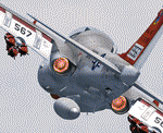
Re-uploaded AlphaSim Grumman A6E intruder in NATC colors, NAval Air Test Center, Patuxent River.
| Filename: | Grumman_A6E_intruder_in_NATC_colors.zip |
| License: | Freeware |
| Added: | 13th May 2010, 21:09:42 |
| Downloads: | 497 |
| Author: | Repaints by pierre lheureux - Plane by Alphasim |
| Size: | 3.65 MB |
| Category: Flight Simulator 2004 - Aircraft Repaints, Textures and Modifications | |
| Ekranoplan "LUN" in Soviet Navy scheme |
|
Images related to this file:
File Description:

Re-uploaded Soviet Navy scheme for Alphasim Ekranoplan "LUN".
| Filename: | Ekranoplan_LUN_in_Soviet_Navy_scheme.zip |
| License: | Freeware |
| Added: | 13th May 2010, 21:08:23 |
| Downloads: | 232 |
| Author: | Repaints by pierre lheureux - Plane by Alphasim |
| Size: | 1.92 MB |
| Category: Flight Simulator 2004 - Aircraft Repaints, Textures and Modifications | |
| Improved Uiver DC2 in boac colours |
|
File Description:
Few additions to original upload:
Registration on wings and a few internal titillations!
Reg No. now correct in 2d and virtual panel
The lights mod will only work if you have the captain sim 727 effect.
| Filename: | Improved_Uiver_DC2_in_boac_colours.zip |
| License: | Freeware |
| Added: | 14th June 2021, 19:00:09 |
| Downloads: | 44 |
| Author: | Michael Evans |
| Size: | 8.97 MB |
| Category: Flight Simulator 2004 - Panels | |
| Documentation in English for A300B4-2C |
|
File Description:
Documentation in English for A300B4-2C panel by Benoit gaurant.
It is strongly recommended to read this file before using A300B4-2C panel v3 by Benoit Gaurant
| Filename: | Documentation_in_English_for_A300B42C.zip |
| License: | Freeware |
| Added: | 8th September 2004, 18:50:25 |
| Downloads: | 2,482 |
| Author: | Benoit Gaurant |
| Size: | 2.45 MB |


© 2001-2026 AVSIM Online
All Rights Reserved
Privacy Policy |