
Where Flight Simulation Enthusiasts Gather from Around the World!
AVSIM Library - Search Results

| Category: Flight Simulator X - Aircraft Repaints, Textures and Modifications | |
| Deer Valley Flying Club Curtiss Jenny JN4D |

|
Images related to this file:
File Description:

Works in both FSX and FS2004 - Aircraft: Curtiss Jenny JN4D Texture Set. Manufacturer Default FS2004 Microsoft aircraft
Livery: Deer Valley Flying Club or DVFC. Created by: Ford Tri-Motor Project Team. Web address: http://www.ford-tri-motor.net
Representing: DVFC or Deer Valley Flying Club - Now in their 11th year, Deer Valley Flying Club is dedicated to flight simulator enthusiasts with a focus more on General Aviation rather then Airline Operations - They are NOT a VA. This is one of over 50 NEW Curtiss Jenny texture sets now available for free at the Ford-Tri-Motor Project site. Accessable via the "Other Aircraft" button on the web site. http://www.ford-tri-motor.net or direct link http://www.ford-tri-motor.net/curtiss-jenny.htm The site also has a copy of the open source Microsoft Default aircraft + a 3 texture pack for Both FS2004 and FSX. Also 2 different Paint Kits available for those that want to experiment with their own repaints. And of course Over 50 other FREE repaints for your entertainment.
| Filename: | Deer_Valley_Flying_Club_Curtiss_Jenny_JN4D.zip |
| License: | Freeware, limited distribution |
| Added: | 22nd August 2014, 16:53:28 |
| Downloads: | 43 |
| Author: | Garry J. Smith and Edward C. Moore |
| Size: | 1.42 MB |
| Category: Flight Simulator X - Utilities | |
| FSX/P3D Quick ILS Utility Ver 3.1.5 **UPDATE ** |
|
Images related to this file:
File Description:
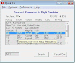
This utility was written to simplify the process of finding the ILS frequency when ATC assigns an ILS approach. Operation is simple. Enter the ICAO, click the Search button and a list of all runways, runway lengths and runway ILS frequencies for that ICAO are displayed. Here's the quick part... Just double click on a runway and the ILS frequency will instantly be set in the Nav1 radio. You can also start Flight Simulator, load a flightplan and then start Quick ILS. It will automatically read the flightplan and then display the destination airport's runway data. Again, just double click on the assigned runway to set the Nav1 radio for the ILS approach. ILS data aside, General Aviation fans may want to use Quick ILS to get information about possible destination airports. Enter an ICAO and you can quickly view the runways available, their length, the surface (ie grass, gravel, paved...) and the runway headings. Version 3.1.5 adds the ILS ID to the display. Freeware by Dave Westbury.
| Filename: | FSXP3D_Quick_ILS_Utility_Ver_315_UPDATE_.zip |
| License: | Freeware |
| Added: | 12th August 2014, 10:25:51 |
| Downloads: | 3,576 |
| Author: | Dave Westbury |
| Size: | 457.35 KB |
| Category: Flight Simulator 2004 - Scenery | |
| YEVD Evans Head Memorial, Australia |
|
File Description:
Googly scenery for YEVD Evans Head Memorial, a former RAAF Training base in
New South Wales, Australia, now reduced to a single runway and small apron.
In its heyday it was home to the RAAF No 1 Bombing and Gunnery and the RAAF No 1
Air Observers Schools and it was said to be the largest training base in the
southern hemisphere - at that time it had four runways.
Flight Simulator 2004 has made no provision for traffic with only a runway
provided and this scenery seeks to redress the situation so that you and your
"AI" traffic can use the airport.
The scenery does not purport to be ultra-accurate. Based on high quality
satellite imagery from Google Earth, the layout is proportionally correct but the
added airport features, such as buildings, are built from default Microsoft objects
and add-on libraries so will not look exactly like the real thing.
You are not obliged to download and install any additional scenery libraries,
but to enjoy this scenery in its entirety, you may wish to. It will work fine,
with or without.
| Filename: | YEVD_Evans_Head_Memorial_Australia.zip |
| License: | Freeware |
| Added: | 19th April 2008, 10:23:02 |
| Downloads: | 544 |
| Author: | John Hinson |
| Size: | 71.78 KB |
| Category: Flight Simulator 2004 - Scenery | |
| DTTR El Borma, Tunisia |
|
File Description:
Googly scenery for El Borma (ICAO: DTTR, IATA: EBM), a small airport with a
long runway deep in the Tunisian desert near the Algerian border. El Borma,
also known as Al Borma or Al Burmah is one of Tunisia's top onshore oil and
natural gas sources and it is this that probably justifies the twice-weekly
flights operated by ATR turboprops of Sevenair.
Microsoft have only provided runways at this airport in Flight Simulator
2004 and this scenery seeks to redress the situation so that you and your
"AI" traffic can use the airport realistically.
The scenery does not purport to be ultra-accurate. Based on high quality
satellite imagery from Google Earth, the layout is proportionally correct but the
added airport features, such as buildings, are built from default Microsoft objects
and add-on libraries so will not look exactly like the real thing.
You are not obliged to download and install any additional scenery libraries,
but to enjoy this scenery in its entirety, you may wish to. It will work fine,
with or without.
| Filename: | DTTR_El_Borma_Tunisia.zip |
| License: | Freeware |
| Added: | 17th December 2008, 16:49:15 |
| Downloads: | 1,027 |
| Author: | John Hinson |
| Size: | 58.32 KB |
| Category: Flight Simulator 2004 - Scenery Design | |
| Simple Instructions for Modifying Land Class |
|
File Description:
Simple Instructions for Modifying Land Class
Land classification, or land class (NOT "landclass"), is how Flight Simulator depicts the ground textures. For much of the FS world, the ground is not representative of the real thing, however. There have been complaints because of this from those who do not understand the cause of the problem.
This document explains the basic concepts behind the land class system, why it is inevitably inaccurate for most of the world, and the very easy-to-use tools with which to fix this.
Also includes instructions for modifying water class.
This is an html document for universal compatibility.
You do not have to be a computer programmer in order to change the land class. Anyone can do it quickly and easily.
So, why complain about it? Do something!
Very sorry - no support of any kind is offered for this document. Please consult the AvSim Scenery Design forum for any questions.
| Filename: | Simple_Instructions_for_Modifying_Land_Class.zip |
| License: | Freeware |
| Added: | 6th February 2005, 04:24:20 |
| Downloads: | 5,072 |
| Author: | Luis, scenery design forum |
| Size: | 2.18 MB |
| Category: Flight Simulator X - Aircraft Repaints, Textures and Modifications | |
| Airbus A330-300RR V2.1 |
|
File Description:
**** THIS FILE SUPERCEEDS MY ORIGINAL FILE posky_a330_300_v2_fsx.zip **** v2.1 - REPORTED BUGS HAVE BEEN CORRECTED. Introducing the Project Opensky A330-300 for Microsoft Flight Simulator X. Designed to be a competitor to the Boeing 777-200, Airbus Industries has out done itself creating a beautiful and fuel efficient flying machine capable of delivering passengers in safety and comfort well into the 21st Century and possibly beyond. Included in this package you will find the Airbus House scheme (With and without SATCOM), Air Canada, Cathay Pacific and Scandinavian Airlines (SAS - with SATCOM) liveries. All textures have been modified in DXT-3 format for crisp visuals without comprimising frame rates. Includes the FS-X default Airbus A321 panel (due to no A330 panel available for FS-X to date). This model has no Virtual Coclpit (VC) and is meant to fly using the 2-D panel only! Sounds have been alised to the default A321, however I recommend the excellent Rolls Royce Trent 700 sound package (file name:rrtrent700v3.zip located at AVSIM.com) for this aircraft. This file is for FS-X Only!
| Filename: | Airbus_A330300RR_V21.zip |
| License: | Freeware |
| Added: | 9th December 2006, 20:20:13 |
| Downloads: | 15,274 |
| Author: | Brian C. Selb |
| Size: | 7.98 MB |
| Category: Flight Simulator 2004 - Scenery | |
| HSSS Khartoum, Sudan |
|
File Description:
Googly scenery for HSSS Khartoum, Sudan. For Sudan's main international airport,
the Flight Simulator depiction is somewhat simplified, depicting just a few
buildings which are badly located. These scenery files attempt to reproduce
the real atmosphere of the airport - from the huge clutter of small hangars
and workshops and large quantities of inactive planes through to the aircraft
dump at the north end of the airport.
The scenery does not purport to be ultra-accurate. Based on high-detail satellite
imagery from Google Earth, the layout is proportionally correct but the added
airport features, such as buildings, are built from default Microsoft objects
and third-party object libraries so will not look like the real thing.
You are not obliged to download and install any additional scenery libraries,
but to enjoy this scenery in its entirety, you may wish to. It will work fine,
with or without. These files complement the Sudan Airways AI Fleet Pack by Billy Rutherford &
John Hinson, updating the scenery files contained therein, but the two are not
inter-dependent.
| Filename: | HSSS_Khartoum_Sudan.zip |
| License: | Freeware |
| Added: | 9th March 2007, 17:29:13 |
| Downloads: | 4,417 |
| Author: | John Hinson |
| Size: | 38.74 KB |
| Category: Flight Simulator X - Scenery | |
| UBBB Baku X DEMO |
|
Images related to this file:
File Description:

Baku X DEMO is the scenery featuring a highly detailed representation of UBBB Heydar Aliyev airport in Azerbaijan. This product is fully compatible with FSX and FSX SE.
It's a fully functional DEMO version of the commercial payware product. It features same airport layout as in the full version but with limited 3D objects and low resolution textures. Using this free demo ensures no problems with online (VATSIM, IVAO, multiplayer etc.) flying in case some users use the payware scenery and some don't.
Heydar Aliyev International Airport (IATA: GYD, ICAO: UBBB) (former Bina International Airport) is the main international airport in Azerbaijan, the home of Azerbaijan Airlines, the national flag carrier.
It's equipped with an automatic installer, which means that the scenery will be automatically added to the Flight Simulator Scenery Library.
Please uninstall all previous versions of this airport you may have installed before. Please make also sure that no duplicated AFCAD files are installed!
Enjoy your virtual flying with Drzewiecki Design!
| Filename: | UBBB_Baku_X_DEMO.zip |
| License: | Commercial demo |
| Added: | 21st May 2016, 20:39:05 |
| Downloads: | 3,843 |
| Author: | Drzewiecki Design |
| Size: | 14.32 MB |
| Category: Prepar3D V1-4 - Scenery | |
| UBBB Baku X DEMO |
|
Images related to this file:
File Description:
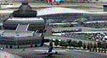
Baku X DEMO is the scenery featuring a highly detailed representation of UBBB Heydar Aliyev airport in Azerbaijan. This product is fully compatible with all versions of Prepar3D.
It's a fully functional DEMO version of the commercial payware product. It features same airport layout as in the full version but with limited 3D objects and low resolution textures. Using this free demo ensures no problems with online (VATSIM, IVAO, multiplayer etc.) flying in case some users use the payware scenery and some don't.
Heydar Aliyev International Airport (IATA: GYD, ICAO: UBBB) (former Bina International Airport) is the main international airport in Azerbaijan, the home of Azerbaijan Airlines, the national flag carrier.
It's equipped with an automatic installer, which means that the scenery will be automatically added to the Flight Simulator Scenery Library.
Please uninstall all previous versions of this airport you may have installed before. Please make also sure that no duplicated AFCAD files are installed!
Enjoy your virtual flying with Drzewiecki Design!
| Filename: | UBBB_Baku_X_DEMO.zip |
| License: | Commercial demo |
| Added: | 21st May 2016, 20:39:16 |
| Downloads: | 1,444 |
| Author: | Drzewiecki Design |
| Size: | 14.32 MB |
| Category: Flight Simulator 2004 - Scenery | |
| EPWA - Warsaw Chopin Airport - Warsaw, Poland ** UPDATED VERSION `` |
|
Images related to this file:
File Description:

EPWA WARSAW CHOPIN AIRPORT 2015 DEMO features an extremely detailed scenery of EPWA Chopin airport in Warsaw, Poland, fully compatible with FS2004.
This product is a fully functional DEMO version of the commercial payware product. It features same airport layout as in the full version but with limited 3D objects and low resolution textures. Using this free demo ensures no problems with online (VATSIM, IVAO, multiplayer etc.) flying in case some users use the payware scenery and some don't.
Warsaw Chopin Airport (WAW / EPWA) is is an international airport located in Warsaw, Poland's capital, which handles just under 40% of the country's air passenger traffic. There are two crossing runways (2800m and 3690m), a number of hangars, a cargo terminal and a passenger terminal, completely rebuilt in 2008-2015.
The product is equipped with an automatic installer, which means that the scenery will be automatically added to the Flight Simulator Scenery Library. Please uninstall all previous versions of this airport you may have installed before. Please make also sure that no duplicated AFCAD files are installed.
Enjoy your virtual flying with Drzewiecki Design!
| Filename: | EPWA__Warsaw_Chopin_Airport__Warsaw_Poland___UPDAT.zip |
| License: | Freeware, limited distribution |
| Added: | 4th March 2016, 15:54:50 |
| Downloads: | 1,038 |
| Author: | Drzewiecki Design |
| Size: | 15.67 MB |


© 2001-2026 AVSIM Online
All Rights Reserved
Privacy Policy |