
Where Flight Simulation Enthusiasts Gather from Around the World!
AVSIM Library - Search Results

| Category: Flight Simulator 2004 - Aircraft Repaints, Textures and Modifications | |
| American Airlines Boeing 757-223 - One World Livery |

|
Images related to this file:
File Description:
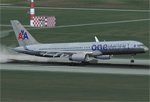
This is repaint of American Airlines Boeing 757-223 - One World livery for Captain Sim 757 Captain. First introduced in 2009 , The One World Alliance livery for American Airlines Boeing 757. You'll need Captain Sim's 757 Captain to use this repaint.
| Filename: | American_Airlines_Boeing_757223__One_World_Livery.zip |
| License: | Freeware, limited distribution |
| Added: | 20th March 2011, 20:44:07 |
| Downloads: | 3,090 |
| Author: | Dennis Kim |
| Size: | 33.35 MB |
| Category: Flight Simulator 2004 - Aircraft Repaints, Textures and Modifications | |
| Seaboard World Airlines Boeing 707-345C |
|
Images related to this file:
File Description:
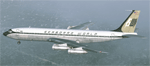
This is repaint of Seaboard World Airlines Boeing 707-345C for Captain Sim Legendary 707. While waiting for DC-8-63CFs, Seaboard World operated 2 leased Boeing 707s.1st aircraft delivered in February 1968 and 2nd 707 delivered on March 1969. Operated with Seaboard until March 31st 1969. N7322S was the first aircraft to be delivered to Seaboard World. You'll need Captain Sim's Legendary 707 to use this repaint.
| Filename: | Seaboard_World_Airlines_Boeing_707345C.zip |
| License: | Freeware |
| Added: | 14th October 2010, 03:49:41 |
| Downloads: | 532 |
| Author: | Dennis Kim |
| Size: | 5.52 MB |
| Category: Flight Simulator 2004 - Scenery | |
| Frazier Lake Airpark (1C9) California Scenery |
|
File Description:
This is a scenery upgrade for Frazier Lake, California (1C9). This is part Eight of a series of small airstrip and minor airfield scenery enhancements which are based on real world data from Google Earth. The scenery mainly reflects the appearance of the airpark from directly above. If you are familiar with the place when on the ground, due to the limited number of buildings available it probably looks quite different. There is now however, a water strip for float planes which was missing from the default. It is proper FS9 water so you may land on it. Also, a few images from the net show that the ground varies from green grass to bare earth so I have made four .bgl files for the base texture. Note, I am using Flight1 Ground Environment; the default fields will look different. You must have rwy12 and EZ scenery libraries installed for the buildings to show. Both libraries of objects are free. EZ Library is available at http://www.abacuspub.com/pub/AbacusEZLibraries.exe. Rwy12 and additional EZ Custom libraries from Avsim. Search under Scenery design.
| Filename: | Frazier_Lake_Airpark_1C9_California_Scenery.zip |
| License: | Freeware |
| Added: | 31st March 2006, 01:00:25 |
| Downloads: | 501 |
| Author: | Kim Gowney |
| Size: | 400.27 KB |
| Category: Flight Simulator 2004 - Scenery | |
| Catania - Fontanarossa, Sicily, Italy (LICC) |
|
File Description:
The new AFCAD and scenery for LICC Catania Fontanarossa Airport
The work in progress for the airport will be finished at the end of 2007
New taxiway inplantation, new air terminal with jetways
| Filename: | Catania__Fontanarossa_Sicily_Italy_LICC.zip |
| License: | Freeware |
| Added: | 22nd August 2006, 22:50:47 |
| Downloads: | 9,559 |
| Author: | Antonio Baeli |
| Size: | 4.1 MB |
| Category: Flight Simulator 2004 - Scenery | |
| Tateyama Air Base (RJTE) |
|
Images related to this file:
File Description:
This scenery brings to life Japanese Maritime Self Defense Force Tateyama Air Base in Chiba Prefecture. Tateyama is home to JMSDF SH-60J anti submarine units and UH-60J Search and Rescue units.
| Filename: | Tateyama_Air_Base_RJTE.zip |
| License: | Freeware |
| Added: | 11th October 2015, 22:34:44 |
| Downloads: | 505 |
| Author: | Brent Newman |
| Size: | 6.3 KB |
| Category: Flight Simulator 2002 - AFCAD Files | |
| KDCA-Ronald Reagan Washington National 5-Part AFCAD |
|
File Description:
KDCA-Washington National 5-part overlay. Requires afcad and ttools. Contains 5 files for DCA. Gates for Northwest, Continental, Delta, American, United, USAirways, and Air Canada. Adds about 50 gates to default scenery.
| Filename: | KDCARonald_Reagan_Washington_National_5Part_AFCAD.zip |
| License: | Freeware |
| Added: | 22nd January 2003, 03:39:08 |
| Downloads: | 871 |
| Author: | Bradley Spies |
| Size: | 17.77 KB |
| Category: Combat Flight Simulator 1 and 2 - Aircraft | |
| Weapons Expansion Package for A-10A Thunderbolt II |
|
File Description:
This package features MORE WEAPONS and LOADOUTS for the A-10A, including Missiles, cluster bombs, guided bombs, rockets, and Napalm. Also included is a CFS2 GPS, effects, and a Mission to allow the user to have a little more fun with all the new weapons. Flies as a separate aircraft.
This file requires the WebinBlue A-10A THunderbolt II for CFS2 available
HERE
(starts Download). You must have intstalled the WebinBlue A-10A for CFS2 in order for the Smokin Hawks weapons Expansion to work. Original aircraft by Filipe Fonseca and Jose Campos, WebinBlue.com Weapons Expansion Package by Chuck Dyer Http://www.SmokinHawks.0catch.com
| Filename: | Weapons_Expansion_Package_for_A10A_Thunderbolt_II.zip |
| License: | Check within download |
| Added: | 25th October 2002, 18:59:59 |
| Downloads: | 1,187 |
| Author: | Chuck Dyer SHP |
| Size: | 535.7 KB |
| Category: Flight Simulator 2004 - Flight Plans | |
| Charles Darwin Voyage of the Beagle |
|
File Description:
On 27th of December, 1831 Charles Robert Darwin, born 1809, sailed from Devonport, England for a five-year voyage around the world on HMS Beagle and returned almost five years later on 2nd of October 1836. On 27th of December 1931 our journey begins in Devonport, near Plymouth in the Imperial Airways' Short S30 LR "Cabot" flying boat to follow this example. Since Charles Darwin also made many in-land journeys on the South American and Australian continents, the flying boat would be unpractical; instead we use the FS2004 default DC-3 for our continental VFR flights. Download and install Jens B. Kristensen's EMPIRE20.ZIP. The stage Cape Verde to Brazil requires Alexander Belov's scenery "Aeropostale Transatlantique" (A_ATLANT.ZIP). Also strongly recommended is Toni Agramont's sceneries ARGNTINA.ZIP plus CHILE_NO.ZIP plus CHILE_SO.ZIP.
| Filename: | Charles_Darwin_Voyage_of_the_Beagle.zip |
| License: | Freeware |
| Added: | 10th November 2009, 21:01:45 |
| Downloads: | 157 |
| Author: | Nis Verkijk |
| Size: | 1.92 MB |
| Category: Flight Simulator 2004 - AFCAD Files | |
| Midway Island (PMDY) |
|
File Description:
Here are two different AFCAD2 files for Midway Island in the Pacific. Runway 06/24 has been extended to 10,000FT and is equipped with full day, night and approach lighting. Parking includes 14 GA ramps, 6 small gates, 1 medium gate, 6 heavy gates and 2 cargo ramps, Helicopter Pads and an enlarged apron. Other extras for this Island are a Tower view, and ATC including ATIS. This makes an ideal pacific stopover or diversion airport. This package has 2 versions - Default AI traffic with Normal gates or Real world AI traffic with airline assigned gates. You can only use one or the other. Bonus files in here include voicepack updates and 2 flights from the Island using default aircraft. This package is meant for the default FS2004 scenery.
| Filename: | Midway_Island_PMDY.zip |
| License: | Freeware |
| Added: | 11th December 2004, 06:03:42 |
| Downloads: | 1,070 |
| Author: | Lee Brompton |
| Size: | 103.41 KB |
| Category: Flight Simulator 2002 - Original Aircraft | |
| ATL 98 Carvair |
|
File Description:
ATL-98 Carvair for FS2002
Version 1.0
GMAX built version of the Classic DC-4 conversion the Aviation Traders Carvair.
Four liveries included 2 X British Air Ferries, British United and BUAF representing
the Carviar in its intended role as a Car Ferry, later used purely in a Freight role
the versatile Carvair saw widespread service world-wide.
2 or three out of the 21 distinctive DC-4/C54 conversions remain operational today.
Fully animated model, with reflective and specular textures. By Jon Walton
Accurate and original Flight Dynamics by FSAviator.
Chief Test Pilot and technical assistance Maarten Brouwer.
NOTE:- THIS IS A SPECIFIC VERSION FOR FS2002! FS2004 USERS SHOULD DOWNLOAD jwat98.zip
| Filename: | ATL_98_Carvair.zip |
| License: | Freeware, limited distribution |
| Added: | 2nd July 2006, 21:05:29 |
| Downloads: | 601 |
| Author: | Jon Walton |
| Size: | 4.01 MB |


© 2001-2026 AVSIM Online
All Rights Reserved
Privacy Policy |