
Where Flight Simulation Enthusiasts Gather from Around the World!
AVSIM Library - Search Results

| Category: Prepar3D V1-4 - Scenery | |
| Airport Kassel EDVK |

|
Images related to this file:
File Description:
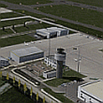
The 5th version of this Add-On for P3Dv4 approaches the reality with photo-realistic ground textures, accurate buildings, runways, taxiways and the official approaches with waypoints, localizers and glide paths. More than 1200 objects, 60 individual scenery-models, approx. 100 custom ground polygons and lines have been created. One big problem was to adopt the terrain mesh to fit the new airport. The actual state of January 2019 has been adapted to the scenery. Photorealistic ground textures have been reworked. High resolution textures you find at the aprons and the vehicle parking areas at the General Aviation and Business Terminals. Accurate Night Lighting and winter textures have been added. All buildings, Hangars and a lot of objects have been designed individually (no library objects). Even the taxiway and apron markings are hand-made. For FSX and P3Dv1 a different version can be downloaded. Works with VFR Germany and ORBX Northern Germany,
| Filename: | Airport_Kassel_EDVK.zip |
| License: | Freeware, limited distribution |
| Added: | 9th February 2019, 19:40:06 |
| Downloads: | 2,793 |
| Author: | Albert Claudi |
| Size: | 105.16 MB |
| Category: Flight Simulator X - Scenery | |
| Los Roques Archipelago and Airports |
|
Images related to this file:
File Description:
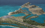
This project rebuilds Venezuela's Los Roques archipelago, adds the Gran Roque (SVRS) and Dos Mosquises (SVDM) airports, and includes AI flight plans, boat traffic, and a custom terrain mesh for Gran Roque. Accurate coastlines and lakes, as well as corrected landclass and waterclass are provided based on the latest available satellite imagery. Although current satellite imagery for this region only exists in relatively low resolution, an abundance of aerial photography was used to add custom features to Gran Roque and Dos Mosquises. Updates were created or rebuilt in a manner which carefully aligned airport data with current satellite imagery, when available. Scenery was created using Airport Design Editor X v1.50.4402, SBuilderX 3.13, and the FSX Object Placement Tool. Scenery objects were added and modified from stock FSX scenery to resemble as closely as possible the actual airports. Thank you to John Hinson and Tiago Besciak for granting permission to adapt their AI flight plans to realistically populate (SVRS) Gran Roque.
| Filename: | Los_Roques_Archipelago_and_Airports.zip |
| License: | Freeware |
| Added: | 27th July 2013, 02:34:10 |
| Downloads: | 1,387 |
| Author: | Carlyle Sharpe |
| Size: | 7.66 MB |
| Category: Flight Simulator 2004 - Scenery | |
| Canlaon Volcano Eruption Scenery |
|
File Description:
Canlaon Volcano is located at the center of Negros Island,Philippines.The twin-peaked massif of Canlaon Volcano (aka Mt. Kanlaon) rises 2,465 meters above the island of Negros just 40-km southwest of the capital Bacolod.This file will add the crater to Canlaon Volcano and will enhance the Landclass surrounding the crater.The crater is real with water.This also adds Visual Effects such as steam,volcanic ashes and lava that will erupt every now and then.Ash falls will fall in the vulnerable surrounding villages of Pula, Malaiba, and Lumanao.The last volcanic activity of Canlaon Volcano recorded by Phivolcs was on June 1-18,2003.
Fly from Bacolod City(RPVB)to Tagbilaran City(RPVT)or Mactan(RPVM) and pass through the highest point of the Island of Negros and behold the beauty of the Canlaon Volcano eruption.
Special steam,ash,and lava effects are visible at daytime and at nighttime.The new Philippine Mesh by Jacques Marie is recommended for achieving realistic topography.You may find it here at avsim,too.
| Filename: | Canlaon_Volcano_Eruption_Scenery.zip |
| License: | Freeware |
| Added: | 10th December 2003, 22:41:38 |
| Downloads: | 3,876 |
| Author: | Ver Walter L. Gulfan |
| Size: | 5.04 KB |
| Category: Flight Simulator 2002 - Scenery Design | |
| Ground2K for Beginners |
|
File Description:
Newly revised for Ground2K version 4
Ground2K version 4 by Christian Fumey is a very easy to use design tool for Flight Simulator terrain scenery. With it, you can create and modify coasts, roads, rivers, lakes, islands, land and water class, altitude mesh, and textured ground polygons.
This short user guide is meant for beginners, and presents some basic concepts concerning Flight Simulator terrain, and a step-by-step explanation of some of the principal functions of Ground2K.
No technical terms are used here, for ease of comprehension.
An HTML document for universal compatibility.
New sections include:
- expanded coverage of basic concepts and functions;
- common problems and errors with solutions;
- glossary of terms
Very sorry - no support is offered for this guide. For any questions, please consult the AvSim forum dedicated to Flight Simulator scenery design.
| Filename: | Ground2K_for_Beginners.zip |
| License: | Freeware |
| Added: | 24th July 2003, 15:24:13 |
| Downloads: | 5,657 |
| Author: | Luis, Scenery Design Fourm |
| Size: | 1.3 MB |
| Category: Flight Simulator X - Scenery | |
| 70 Colombia Airports |
|
File Description:
70 Colombia airports/airfields for FSX. Mainly based on GoogleEarth. Changes to default airports and many new airports added. Largely based on my formerr FS9 colombian airport sceneries. I am using the FreeMesh X Global 1.0 from https://www.avsim.com/forums/topic/467933-freemesh-x-global-10-release-announcement/ but most sceneries should work also with the default or any other mesh. All files start with the ICAO identifier of the airport; so you can take out what you don't like or use only what you like.
Airports included are: ACM (IATA Code), SK53,SKAG,SKAO (now SKMJ) SKAS, SKBC, SKBE, SKBM, SKBN, SKBQ, SKBS, SKBU, SKCA, SKCB, SKCI, SKCN, SKCR, SKCZ, SKEB, SKFE, SKFL, SKGA, SKGI, SKGY, SKHA, SKHC, SKIB, SKIM, SKIO, SKIR, SKLA, SKLB, SKLC, SKLP, SKLT, SKMF, SKMG, SKMO, SKMO, SKNA, SKNV, SKOE, SKOT, SKPA, SKPD, SKPI, SKPP, SKPV, SKPZ, SKQU, SKRI, SKSA, SKSF, SKSJ, SKSV, SKTB, SKTM, SKTQ, SKUA, SKUM, SKUR, SKVG,
SLVP, SQFR, SQOA, SQPS, SQUJ, SQVZ, Z09A
| Filename: | 70_Colombia_Airports.zip |
| License: | Freeware |
| Added: | 6th January 2019, 17:39:01 |
| Downloads: | 2,406 |
| Author: | Detkev J. Rohmer |
| Size: | 106.4 MB |
| Category: Flight Simulator 2004 - Aircraft Repaints, Textures and Modifications | |
| Aviogenex Boeing 737-2K3 Advanced (YU-ANP) |
|
Images related to this file:
File Description:
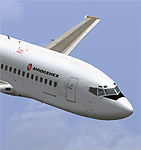
Accurate rendition of sole Aviogenex Boeing 737-2K3 Advanced, registered YU-ANP. Being the only remnant in the fleet of the once largest Yugoslavian charter carrier, this 22 year old 737 still flies to a number of destinations in Turkey, Egypt, Spain, Greece and Italy, among many ad hoc flights for the Serbian national carrier Jat Airways.
Aviogenex (ÐвиогенекÑ) is a Serbian charter airline. It operates regular and ad hoc charter flights as well as wet-lease services, worldwide. Its main base is Belgrade Nikola Tesla Airport. Founded in April 1968 the airline has more than 40 years of experience. During 1969 Aviogenex operated its first flight from Belgrade to Düsseldorf on a Tu-134 aircraft.
Through 1990, the airline flew 633,932 passengers, with 5 Boeing 727 and 5 Boeing 737 aircraft, reaching roughly 17000 flight hours per year. Since 1991 Aviogenex has oriented towards leasing of aircraft and crews, and achieved more than 40000 flight hours. Throughout this period Aviogenex operated in Europe, Africa, the Middle and Far East, and South America. In 2010 they restarted flights under their own name using a Boeing 737-200 Advanced (the one represented in this re-paint).
I've paid a lot of attention to detail, so the aircraft is as it looks like in July 2010. Hope you will enjoy flying this lovely bird. Textures only - needs the TinMouse B737-200 aircraft available at AVSIM (tinmouse_ii_v1_25.zip)
| Filename: | Aviogenex_Boeing_7372K3_Advanced_YUANP.zip |
| License: | Freeware, limited distribution |
| Added: | 21st July 2010, 11:20:31 |
| Downloads: | 1,278 |
| Author: | Predrag Danicic, TinMouse Project |
| Size: | 5.35 MB |
| Category: Flight Simulator X - AFCAD Files | |
| PAOT - Wien Meml - Kotzebue, Alaska |
|
Images related to this file:
File Description:
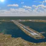
This AFCAD of the airport Wien Meml - Kotzebue (PAOT), Alaska, fixes some issues for Scenery Solution's UTX Alaska users who want to use mesh and texture resolutions better than 38 m and 1 m, respectively. Unfortunately this discloses some additional problems with lagoons surrounding runway 09/27. Some of the ponds had been elevated over apron level, the fence Microsoft had drawn around the airport ran through (elevated) water and so on. Runway 27 has no direct connection to the mainland like it is realized by UTX and furthermore a lot of water polygons (including the lagoons) had 'forgotten' shore line vectors. Included corrections are: fixed main waterpolygons around the airport (according to Google Maps), fixed airport layout, including aprons, GA parking, additional airport buildings (default FSX objects), fixed Runway designators (now 09/27 resp. 18/36 instead of 08/26 and 17/37, Nov. 2013), added shoreline vectors (compatible to UTX textures) and some more.
Again, THIS AFCAD IS INTENDED FOR USERS OF UTX ALASKA ONLY and will likely look horrible in other environments as it partially amends missing features only.
| Filename: | PAOT__Wien_Meml__Kotzebue_Alaska.zip |
| License: | Freeware, limited distribution |
| Added: | 3rd February 2014, 14:30:10 |
| Downloads: | 409 |
| Author: | Axel Birsul |
| Size: | 1.09 MB |
| Category: Flight Simulator 2002 - Scenery | |
| Alaska Bush Scenery: Stony River Bend & Old Stony |
|
File Description:
Here's your big chance to take-off and land using a curved airstrip. Stony River Bend is located just west of Merrill Pass, very close to Tom Fica's cabin at Two Lakes (part of his 'Merrill Pass' scenery add-on). The bumpy dirt runway - becoming slightly overgrown and prone to waterlogging - is marked out with wooden posts (lit at night) and presents a unique challenge: one that I haven't really sorted out just yet! There's a small settlement just up a log-lined trail from the airfield with a gravel service track connecting with a basic NDB/DME facility to help out with night or low visibility approaches. Although Stony River Bend is fictional, it has been based loosely on a real life runway at Elk City in Idaho. Three miles downstream is another simple backwoods strip called Old Stony - the narrow gravel runway here is conventional, but it's probably in an even worse state of repair. Designed for use with Eddie Denney's FS2002 mesh of Alaska, but the scenery is usable without it.
| Filename: | Alaska_Bush_Scenery_Stony_River_Bend__Old_Stony.zip |
| License: | Freeware, limited distribution |
| Added: | 31st March 2003, 13:09:28 |
| Downloads: | 1,873 |
| Author: | James Belk |
| Size: | 2.04 MB |
| Category: Flight Simulator X - AFCAD Files | |
| Coombs Airport (7NJ7), NJ |
|
File Description:
Located 04 miles NE of Elmer, New Jersey, Coombs Airport is a private turf field 2000' in length wilth clear 20:1 approach and departure at each end of the runway. You'll find some surrounding buildings but they are all located several hundred yards from the runway. This is a good strip to keep in mind for emergencies if you're in the area. You will be landing on terrain so having your mesh complexity set as high as possible is recommended. This airport is not lit at night, daytime VFR operations only are suggested. There are no transient services offered.
Scenery constructed with use of satellite images/streetview/aerial photos - the author has not been there in person.
This scenery is meant to be used in conjunction with MegaScenery Earth New Jersey/Delaware 004. It is not required, but apron use is minimized to allow satellite scenery to show through as much as possible, and objects are placed based on the MSE textures - lack of it may make scenery look out of place.
| Filename: | Coombs_Airport_7NJ7_NJ.zip |
| License: | Freeware |
| Added: | 16th February 2011, 00:03:55 |
| Downloads: | 191 |
| Author: | Drew Sikora |
| Size: | 756.22 KB |
| Category: Flight Simulator X - AFCAD Files | |
| Rainbow's End Airport (JY39), NJ |
|
File Description:
Located 07 miles S of Salem, New Jersey on 20 acres of land, Rainbow's End Airport is a private turf strip 2200' in length. There are no services for transient aircraft and the airport is not lit at night, so daytime VFR operations only are recommended. If you have an aircraft with 40' or less of wingspan you can start at one of the parking spaces east or west of the runway by the hangars. Otherwise it is suggested you start on the runway. There is no hard surfaced runway so set your terrain mesh as high as possible.
Scenery constructed with use of satellite images/streetview/aerial photos - the author has not been there in person.
This scenery is meant to be used in conjunction with MegaScenery Earth New Jersey/Delaware 005 & New Jersey/Delaware 004. It is not required, but apron use is minimized to allow satellite scenery to show through as much as possible, and objects are placed based on the MSE textures - lack of it may make scenery look out of place.
| Filename: | Rainbows_End_Airport_JY39_NJ.zip |
| License: | Freeware |
| Added: | 12th May 2011, 00:58:29 |
| Downloads: | 173 |
| Author: | Drew Sikora |
| Size: | 626.46 KB |
© 2001-2026 AVSIM Online
All Rights Reserved
Privacy Policy |