
Where Flight Simulation Enthusiasts Gather from Around the World!
AVSIM Library - Search Results

| Category: Flight Simulator 2004 - Scenery | |
| Reservoirs and Lakes of Lesotho and Western Natal, South Africa |

|
File Description:
Replacement files for water bodies of eastern South Africa, in and near the Drakensberg Range (S28.1-29.5 E28.3-30.0). Natural and man-made lakes are now in their accurate position and elevation. Includes the Katse Dam reservoir in Lesotho as well as about 100 smaller lakes in Lesotho and western Natal not present in the FS default scenery. Based on a watermask derived from Landsat 7 ETM+ satellite data and compiled with a beta version of Jim Keir's "Slartibartfast" utility. Meant to be used with the Aeroworx SRTM LOD9 South Africa mesh.
| Filename: | Reservoirs_and_Lakes_of_Lesotho_and_Western_Natal_.zip |
| License: | Freeware, limited distribution |
| Added: | 8th May 2004, 02:43:38 |
| Downloads: | 6,205 |
| Author: | Holger Sandmann, Aeroworx |
| Size: | 464.27 KB |
| Category: Flight Simulator 2004 - Original Aircraft | |
| Fairchild F-91 |
|
File Description:
FS2004 Fairchild F-91: In 1935 Pan American engineers working closely with A. A. Gassner developed this amphibious aircraft that was to be known as the Fairchild F-91. It was an all metal shoulder wing monoplane intended to carry eight passengers. The aircraft featured fully retractable landing gear . While a very attractive airplane only eleven were ever produced with two of those going to the Brazilian subsidiary of Pan American for use on the Amazon River. Two F-91s went to the Japanese Navy for testing and were used as liaison aircraft. The last F-91 produced was purchased by American Millionaire Gar Wood who had it named “Wings of Mercy” and painted in RAF colors. He donated it to the RAF and they sent it to Egypt to perform SAR duties.
Model, VC Panel, Panel, flight dynamics & Textures By Chris Herring
| Filename: | Fairchild_F91.zip |
| License: | Freeware, limited distribution |
| Added: | 19th January 2007, 15:20:20 |
| Downloads: | 1,894 |
| Author: | Chris Herring |
| Size: | 17.08 MB |
| Category: Flight Simulator 2004 - Flight Plans | |
| 1934 - Brisfit to Baghdad |
|
File Description:
The idea for this real-life Flight came from the pages of the October 2007 edition of "Aeroplane Monthly', a magazine which has been the source of inspiration for a couple of Flights that I've created. In this one, two university undergraduates - one the pilot, the other a friend who wanted to go to Iraq
to see his parents - fly an old Bristol Fighter from England to Baghdad via France, Belgium, Germany, Austria, Hungary, Yugoslavia, Bulgaria, Turkey and Syria and then return via Jordan, Egypt, Libya, Tunisia, Italy and France. The 'Brisfit' they bought for 100 pounds. Built in 1918, it had been declared surplus by the Air ministry in 1924 and was registered G-ABYE. The journey began on August 10th. 1934 and they returned on September 17th.
ReadMe included with the simple installation instructions.
| Filename: | 1934__Brisfit_to_Baghdad.zip |
| License: | Freeware |
| Added: | 1st October 2007, 21:31:15 |
| Downloads: | 625 |
| Author: | Bruce Kennewell |
| Size: | 1.01 MB |
| Category: X-Plane - Scenery | |
| WXPJ Susi Air Puncak Jaya Mining Airstrip v1.0.0 |
|
Images related to this file:
File Description:
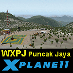
This is an X-Plane 11 scenery for Puncak Jaya Mining Airstrip (WXPJ) in the Puncak Jaya mountain region of Papua, Indonesia. This is a fictitious airfield, located in a high altitute mining location in Papua. At 4884 metres (16024 ft) above sea level, the Puncak Jaya peak, next to the mining location, is the highest mountain in Indonesia, on the island of New Guinea (which consists of the Indonesian West Papua region plus Papua New Guinea). This fictitious airfield may serve as a high altitute mining location challenge while flying the airstrips in Papua, as one of the destinations for "PT ASI Pujiastuti Aviation", operating as Susi Air, an Indonesia airlines established in late 2004 by Mrs. Susi Pudjiastuti. This scenery was tested and is operational (as of January 20, 2017) in "X-Plane 11 Public Beta #6 64 bit", Windows 10 Home. It was also tested and is partially operational (as of January 20, 2017) in "X-Plane 10.51 64 bit", Windows 10 Home. The issue with XP10 is the mesh again: there is no mine mesh, just a whole. The feel is very different from XP11, but it is still operational in XP10 to fly in and out.
| Filename: | WXPJ_Susi_Air_Puncak_Jaya_Mining_Airstrip_v100.zip |
| License: | Freeware |
| Added: | 21st January 2017, 18:42:35 |
| Downloads: | 58 |
| Author: | Rui Mesquita |
| Size: | 2.2 MB |
| Category: Flight Simulator 2004 - Scenery | |
| New York City Default Bridges and Objects v2.0 |
|
File Description:
I originally planned on "fixing" the George Washington Bridge, which was inadvertantly "sunk" by FSG's 38m mesh, and ended up repositioning and scaling a whole bunch of other default bridges and objects within about 50 miles of NYC. This addon was designed and tested for use with FS 9.1, FSG 38m mesh (available here at AVSIM), and Freeflow NE, UT/USA and USA Roads. It should also work with other road and water packages. I did not create any new scenery, I only repositioned default objects to their correct locations.
This should be the final version for a while. This version was tested with and adds compatibility for Megascenery NY and Aerosoft's Manhattan scenery. I also removed a few more objects that were placed in the water, and moved back to land a bunch of cranes around KEWR that were in the water.
Fixed stuff: All inappropriately placed NYC and Newark bridges (major, not autogen) up to Bear Mountain in the north and south to about the Verrazanno; Belmont Racing track; Shea Stadium; Meadowlands Stadium; World's Fair Tower; US Open Stadium. Added Meadowlands Race track and a few bridges around Newark, moved cranes around KEWR back to land, removed several objects in the water.
| Filename: | New_York_City_Default_Bridges_and_Objects_v20.zip |
| License: | Freeware |
| Added: | 10th November 2005, 16:48:46 |
| Downloads: | 6,557 |
| Author: | Thomas Perry |
| Size: | 558.69 KB |
| Category: Flight Simulator 2004 - AI Flight Plans | |
| Afriqiyah Airways Winter 2008 |
|
File Description:
Winter 2008 flightplans for Afriqiyah Airways (Tripoli - Libya).
Fleet is: 1 Boeing B757-200;
2 Airbus A319;
5 Airbus A320-200.
Afriqiyah Airways operates between cities from Libya (Benghazi, Tripoli), Belgium (Brussels), Benin (Cotonou), Burkina Faso (Ouagadougou), Cameroon (Douala),
Central African Republic (Bangui), Chad (N'Djamena), Egypt (Cairo), France (Paris - CDG), Germany (Dusseldorf), Ghana (Accra), Italy (Rome - FCO), Cote d'Ivoire (Abidjan),
Mali (Bamako), the Netherlands (Amsterdam), Niger (Niamey), Nigeria (Lagos), Saudi Arabia (Jeddah), Senegal (Dakar),
Sudan (Khartoum), Switzerland (Geneva), Togo (Lome), the United Arab Emirates (Dubai) and the United Kingdom (London - LGW).
Repaint: (On Avsim.com)
B752 -> aig_752_euroatlantic.zip by JW Bakker & Alpha India Group;
A319 -> a319_afriqiyah.zip by Juergen Baumbusch;
A320 (5A-ONA, 5A-ONB) -> a320_afriqiyah.zip by Juergen Baumbusch;
A320 (S5-AAA) -> a320_afriqiyah_adria.zip by Juergen Baumbusch;
A320 (TS-INA, TS-INM) -> ev320aaw.zip by Arnaud Solvay, Alexis Solvay.
Afcad/Scenery: (Avsim.com)
Look for afcad files by Peter Bos.
| Filename: | Afriqiyah_Airways_Winter_2008.zip |
| License: | Freeware |
| Added: | 27th November 2008, 03:21:07 |
| Downloads: | 802 |
| Author: | Francois Massin |
| Size: | 9.36 KB |
| Category: Flight Simulator 2004 - Scenery | |
| Byron Bay, Cape Dyer, Cape Hooper, Dewar Lakes, and Durban Island adapted for the FSGenesis 76m North Canada Terrain Mesh |
|
Images related to this file:
File Description:
These are replacement bgl's to convert five northern Canada fields for use with the FSGenesis 76m terrain mesh for northern Canada. The five are Byron Bay CWBB, Cape Dyer CWFD, Cape Hooper CWFH, Dewar Lakes CWFL, and Durban Island CWFB. These are not stand-alone, and the presumption is that you have already downloaded and installed the previously posted sceneries. The installation consists solely of replacing the existing scenery bgl's with the new. There will be further posts of northern airfields in groups of five, alphabetically, and observations regarding the amendments and any further corrections that are required would be welcomed.
| Filename: | Byron_Bay_Cape_Dyer_Cape_Hooper_Dewar_Lakes_and_Du.zip |
| License: | Freeware, limited distribution |
| Added: | 3rd September 2017, 20:01:55 |
| Downloads: | 73 |
| Author: | Roger Wensley |
| Size: | 3.49 MB |
| Category: Flight Simulator 2004 - Scenery | |
| Edinburgh Island, FOX-2, Horton River, Igloolik, & Kimmirut, adapted for the FSGenesis 76m North Canada Terrain Mesh |
|
Images related to this file:
File Description:
These are replacement bgl's to convert five northern Canada fields for use with the FSGenesis 76m terrain mesh for northern Canada. The five are Edinburgh Island CWEI, the FOX-2 DEW line station, Horton River CWHR, Igloolik CYGT, and Kimmirut CYLC. These are not stand-alone, and the presumption is that you have already downloaded and installed the previously posted sceneries. This installation consists solely of replacing the existing scenery bgl's with the new. There will be further posts of northern airfields in groups of five, alphabetically, and observations regarding the amendments and any further corrections that are required would be welcomed.
| Filename: | Edinburgh_Island_FOX2_Horton_River_Igloolik__Kimmi.zip |
| License: | Freeware, limited distribution |
| Added: | 10th September 2017, 19:29:57 |
| Downloads: | 86 |
| Author: | Roger Wensley |
| Size: | 3.55 MB |
| Category: Flight Simulator 2004 - Scenery | |
| Private Strips - revisited |
|
File Description:
Herewith my previously uploaded collections of various Private/Extra/Grass/Microlight/Miscellaneous etc. airfields from around England and Wales, all now in one place and re-edited with parking and taxiways for the facilitation of ai aircraft.
Please note :- these sceneries have been designed for use in FS2004 with the original UK VFR Photographic scenery and mesh. They rely for details on the "usual" collections of library objects, specifically EZ-Scenery, UKVFR and Rwy12 libraries. Whilst other configurations will probably work, to a degree, you'll have to try them and see if they suit you.
See the enclosed ReadMe for further details.
| Filename: | Private_Strips__revisited.zip |
| License: | Freeware |
| Added: | 6th March 2021, 16:15:32 |
| Downloads: | 156 |
| Author: | Chris Eve |
| Size: | 2 MB |
| Category: Flight Simulator 2004 - Scenery | |
| Project Mexico Real LOD10 File 1 of 11 |
|
Images related to this file:
File Description:
File 1st of 11 of a Terrain Mesh that covers the entirety of Mexican Territory and related bordering U.S., Guatemala and Belice areas, part of the "Proyecto Mexico Real" project, compiled at LOD10 (1.24 arcseconds in latitude and 1.65 arcseconds in longitude) resolution from INEGI data. Intended to enhance the virtual flying experience complementing the LOD8 and LOD9 versions compiled from the same data. Compatible backwards with Flight Simulator 2000, Flight Simulator 2002 and Combat Flight Simulator 2. Refer to the file contents about the cover area to this compressed file. (Re-upload due to AVSIM hack)
| Filename: | Project_Mexico_Real_LOD10_File_1_of_11.zip |
| License: | Check within download |
| Added: | 6th June 2010, 09:05:59 |
| Downloads: | 4,164 |
| Author: | Juan Jose Galvan Bautista |
| Size: | 73.44 MB |


© 2001-2026 AVSIM Online
All Rights Reserved
Privacy Policy |