
Where Flight Simulation Enthusiasts Gather from Around the World!
AVSIM Library - Search Results

| Category: Flight Simulator X - Aircraft Repaints, Textures and Modifications | |
| Consolidated PBY-5A (C-FCRR) |

|
Images related to this file:
File Description:

This folder contains a repaint for the Aerosoft PBY Catalina for FSX. It is shown here as C-FCRR, with Air France colors. Built by Boeing of Canada at Vancouver, it became RCAF Canso 9767 on March 4, 1943, and was allocated to Squadron 162, coded S, at Reykjavik, Iceland. In 1944, piloted by Flying Officers Thomas Charles Cooke and Eric Walter Wiskin, 9767 sank the German U-boat U-342 off the coast of Iceland on April 17. The amphibian was removed from the military service on April 1, 1946. The same year it was sold to Canadian Pacific Airlines, registered CF-CRR and assigned fleet number 233 (later 933), it was operated until 1959, thereafter by Northland Airlines (1960-1968), Midwest Airlines (1969-1970), and Ilford Riverton until 1973. The registration was changed to C-FCRR when Avalon Aviation acquired it as a water bomber in 1977, listed as Tanker number 791.
In 1995 the aircraft was bought by Powell Eorp. Of Parry Sound, Ontario, subsequently it was owned by the Canadian Air Legend. The French pilot Franklin Devaux bought C-FCRR in 1995 and converted it to a flying television studio, it was based at Le Bourget, Paris, France. During 1996 C-FCRR was the star of monthly French television programme Operation Okavango, while in September 1998 it was the eye catcher of the three-week Champs-Elysees (Paris) static air show. The following October the aircraft started an 8,078 mls (13,000 km) trip to Chile via Dakar (Senegal) and Natal (Brazil) to commemorate early Air France South Atlantic mail service, returning to France in June 1999. On January 19, 2002 the aircraft was stored at Orly Airport, Paris, and has not flown since. Its Canadian registration was cancelled on October 7, 2005. At present it seems to be registered as N9767, and in airworthy condition again. Here's a youtube movie on this aircraft: http://www.youtube.com/watch?v=s6jyzV8Gawc. Repaint by Jan Kees Blom, based on the repaint kit by Aerosoft.
| Filename: | Consolidated_PBY5A_CFCRR.zip |
| License: | Freeware |
| Added: | 13th July 2018, 20:34:21 |
| Downloads: | 154 |
| Author: | Jan Kees Blom |
| Size: | 9.83 MB |
| Category: Miscellaneous Files - General Utilities | |
| Random Airport Generator |
|
Images related to this file:
File Description:
I can be contacted at [email protected] for any help required or different drive versions needed.
[ABOUT THE PROGRAM]
This program will read a text file from the route of your hard drive depending on the version you run, and select a random line and display that line. The file must be a text file named "Airports.txt". This program was designed with ease of use in mind for selecting a random airport for the Flight Sim community, though can be used for any purpose with any text file called "Airports.txt". The program will display the airport ICAO code then co-ordinates.
[ABOUT ME]
I am a 16 year old aviation enthusiast that loves flying and ATC, but hate having to choose an airport to depart from and arrive at, or to controll. This program has now removed this to make my flight more random with less decisions to make. I also like to explore areas I haven't been before, again this selects a random airport, from thousands of different ones, so exploring is inevitable.
[INSTALLATION]
The only installation required is to copy the Airports.txt file to the route of your hard drive C: or D: (for more drives e-mail me as above), then run the respective program for that drive from any folder you wish.
[ABOUT THE AIRPORTS.TXT FILE]
This file was collected from my FS2004 and contains every airport in it. Currently the program selects a line at random and displays it, whether a large international airport or small grass field. You could edit the file just to contain your favourite airports and it will NOT affect the running of the program as long as the file remains as Airports.txt. I am hoping in future versions to allow you to select a type of airfield, i.e. large, medium or small or select from runway length, though this will take a while to produce, if ever.
For now i hope everyone enjoys the program and happy flying :)
| Filename: | Random_Airport_Generator.zip |
| License: | Freeware |
| Added: | 9th June 2010, 02:41:14 |
| Downloads: | 212 |
| Author: | Alexander Aschacher |
| Size: | 254.45 KB |
| Category: Flight Simulator 2004 - Original Aircraft | |
| Savoia Marchetti SM.79 Sparviero (V.01) |
|
Images related to this file:
File Description:
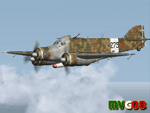
It was the most important Italian bomber of World War II, this tough three-engined aircraft established a reputation that contrasted with most Italian weapons of the day, and it was flown with courage and skill. SM.79s served widely in the normal bombing role, but it is as a land-based torpedo bomber that the type deserves its place in military aviation history, being regarded by many as one of the finest torpedo bombers of the war.
The basic design continued the company's tradition of mixed construction with steel tubes light alloy wood and fabric (this being the only way to produce in quantity with available skills and tools); in spite of its cumbersome appearance and outdated construction, the S.M.79 was a rugged, reliable multi-role medium bomber which did quite a bit of damage in the face of heavy opposition. About 1,300 production models were built over a nine year period. They had internal provision for 2,750 lb (1,250 kg) of bombs, supplemented by under fuselage rack for a torpedo. The SM.79 had a distinctive 'hump' on the upper forward fuselage, which housed both the fixed forward-firing heavy machine-gun and the dorsal gunner's position. Its appearance earned the aircraft the nickname 'Gobbo Maledetto' ('Damned Hunchback'). Post-war surviving SM.79s were converted into various versions of utility transports during the last phases of the war and survived in that role until 1952.
Complete aircraft. 4 Different Hi-Res GMax models (4 different versions), features the usual moving parts, such as all flight controls, props pitch and leading edge flaps. Six different liveries (2 Regia Aeronautica, 1 A.N.R./R.S.I. , 2 Spanish Nationalist Air Force, 1 Italian Co-Belligerant Air Force); VC only. Tested in FSX. Original CFS3 Model by Italianwings, converted and modified for FS2004 by Manuele Villa, January 2008. Installation instructions and paint-kit included.
| Filename: | Savoia_Marchetti_SM79_Sparviero_V01.zip |
| License: | Freeware |
| Added: | 26th May 2010, 10:19:15 |
| Downloads: | 5,021 |
| Author: | Manuele Villa, Italianwings |
| Size: | 27.75 MB |
| Category: Flight Simulator 2004 - Scenery | |
| Iles de la Madeleine CYGR in Quebec Canada |
|
Images related to this file:
File Description:
The Iles de la Madeleine are a group of spit islands linked by bridges in the Gulf of St Lawrence. They are east of New Brunswick, north of Cape Breton Island, west of the Island of Newfoundland, and south of the mainland coast of Quebec. On a southwest to northeast axis they are 40 miles in length and the airport CYGR is pretty much at the midpoint of the southern line of islands. Take a look at the overhead from FS9 to see what I mean. CYGR has two runways, one is aligned 08-26 and is just under 4,400 feet long and 150 feet wide with lighting and PAPI at both ends. The second is aligned 16-34 and is 3,600 feet long and 150 feet wide, without lights or PAPI. Both are asphalt. The apron is not huge, and a newish (in 2010) hangar was built with separate access to the 16-34 runway. There are daily flights by Air Canada and Pascan Aviation included in the AI. The AI also includes some boats and a ferry, and I first used these with my Dutch Harbor scenery, so if you have that already.... This scenery also includes Cindy Hook, a small boat harbour just 2 miles southwest of the airport, and the larger harbour at Cap aux Meules a further 3 miles away that accommodates the daily ferry trips, along with fishing boats etc. Also included here is a further addition to the Homer PAHO scenery in the shape of a boat that is included in the Homer Spit harbour. Just add the contents of the scenery folder to the Homer scenery folder of your Homer installation, and the texture folder contents to the Homer texture folder. This is hopefully the last PAHO addition, and again apologies. If you find an error email me please, and note that my email address has been changed to rogwens at Gmail dot com.
| Filename: | Iles_de_la_Madeleine_CYGR_in_Quebec_Canada.zip |
| License: | Freeware, limited distribution |
| Added: | 28th July 2021, 17:02:18 |
| Downloads: | 193 |
| Author: | Roger Wensley |
| Size: | 26.7 MB |
| Category: Flight Simulator X - Aircraft Repaints, Textures and Modifications | |
| FSX/P3Dv3 Alisarda F-27-200 1973 |
|
Images related to this file:
File Description:
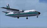
This is a repaint of the F-27-200 in Alisarda colors. The freeware FSX Native with VC F-27-200 by Bjorn Kesten is needed for this repaint. It was converted from Mike Stone's and Tom Gibson's models. The textures are 32bit DDS. It was tested on FSX-SE, but should work on FSX & P3Dv3.
Alisarda was an Italian airline based at Olbia, in Sardinia. It was established on March 28, 1963 as an air taxi company registered under the official name Linee Aerea della Sardegna SpA. Their first aircaft were two Beech 18s and Alisarda only provided a charter service. However, one year later,in 1964, they opened their fist scheduled service from Olbia to Rome. 1965 proved to be a pivotal year for the carrier. A reorganization was carried out whereby an agreement was concluded with Algenova for technical and commercial support. New investors were found, and in February 1965 two new Nord 262s were ordered from Nord Aviation. Due to this greater transport capacity, the transport figures increased strongly and in 1966 a total of 5,640 passengers were transported. The passenger loads increased dramatically in 1968 and 1969, so, Alisarda purchased three F-27 Friendships to take up the extra loads. The airline entered the 1970s with strength, and in January 1974 they received their first pure jets with the purchase of two DC-9-14s from Delta Airlines, I-SARJ and the I-SARV. 1977 saw them purchase two DC-9-32s, followed by three DC-9-50s in 1983, which replaced the aging DC-9-14s. In 1984 they received two new Maddog 82s. Their route network by 1989 consisted of domestic flights to many cities in Italy, plus international routes to Zurich, Geneva, Munich, Frankfurt, Paris, and Nice. In 1991 Alisarda merged with the Spanish carrier Universair, as the shareholders wanted to become a bigger players on the European market. The new carrier was named Meridiana. Thus, the name Alisarda ceased to exist.
| Filename: | FSXP3Dv3_Alisarda_F27200_1973.zip |
| License: | Freeware |
| Added: | 21st January 2020, 17:49:09 |
| Downloads: | 83 |
| Author: | Ted Giana |
| Size: | 4.79 MB |
| Category: Flight Simulator X - Aircraft Repaints, Textures and Modifications | |
| Airbus A318 FD Special Version V3 - Complete Pack |
|
Images related to this file:
File Description:
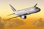
This is the new version of my Airbus A318 with the Panel in V3 opened on the A321. I remind you that this aircraft is based on the Project Airbis A318, with an ehanced panel based on the work of stefan Liebe.
This latest development can see the more realistic Airbus available as freeware. With a new version of the panel, the aircraft has a 100% cold & dark Status at the start of a flight, a real fuel system management with all valves, piumps and crossfeed work, the complete Bleed circuit with X-bleed, a real engines manual startup procedure like the real aircraft. I have also ehanced the navigation display with TCAS function in ARC and NAV mode; There is also the engines failure procedure to work (fire, oil leaks....) and many improved function that I cannot describe here. The aircraft comes with user manual in English and in French, and it is essantial to read it before you fly.
All the functions of the V2 have been kept and improved, like the vertical navigation gauge, the terrain radar map on the navigation display, the autolanding function, the SFCC. Aircraft comes with 6 liveries (Air France and 5 Frontier liveries realized by Project Airbus Team). This version is only in CFm engines, but with real engine data (CFM56-5B9). Now, the Fly By wire works in 2 modes: "Normal Law" and "Direct Law". I put 300 hours into the development of this panel and I hope that you will like it. In the coming weeks, I will adapt this panel to the A319 V2 and A320 V2, that are the these are the last aircrafts that I must update with this new panel. Please, note that this panel is the v3.05 version, witch fixes the bugs of the first version that came with the A321 (there is an update panel for the A321). Francois Dore
| Filename: | Airbus_A318_FD_Special_Version_V3__Complete_Pack.zip |
| License: | Freeware, limited distribution |
| Added: | 17th June 2012, 13:18:21 |
| Downloads: | 19,611 |
| Author: | Francois Dore, Project Airbus |
| Size: | 110.04 MB |
| Category: Prepar3D V1-4 - Utilities | |
| GENav pro Navigation |
|
Images related to this file:
File Description:

Previous payware product at SimMarket, now 100% free.
With GENav pro you will view all AIRAC navigation data and terminal procedures inside Google Earth. GENav pro run under Windows and require only Google Earth for displaying. You can also edit your own routes or just copy routes into GENav to view in Google Earth. You can search for example an airport or a fix by short or long name, Google Earth will take you there.
You can connect to Microsoft Flight Simulator to view your aircraft. Moving map and heading is available.
GENav pro is highly optimized for best performance and clear views without clutter. There are smart filters to select relevant data to display, all AIRAC items are available. You will find all data such as nav-aid frequencies, airport runways with ILS frequencies by click the displayed icons in Google Earth.
You can edit routes visual direct inside Google Earth by click. The database can always be updated with Navigraph's latest AIRAC data.
With GENav you can easy build valid routes. Unlike other common autorouting program, GENav is the tool for you to build routes with correct airway direction and correct connected to SID/STAR's. You will easy draw your routes most stright and correct to destination. It is also excellent for visual and instrument navigation flights.
FEATURES:
*** Display airports, nav aids, waypoints
*** Display High/Low airways and airways direction
*** Display SID/STAR, Approaches and Transitions
*** Display ARTCC/FIR border
*** AIRAC data available by click
*** Search airport and fixes
*** AIRAC data compatible Navigraph data
*** Visual editable routes
*** VOR to VOR route navigation data
*** Display your aircraft
BASIC SYSTEM REQUIREMENTS:
*** Windows with Google Earth installed
( Notice, no flightsim program required )
OPTIONALLY REQUIREMENTS:
*** SID/STAR require the Navigraph purchase or an alternative free source
*** Airways direction & high/low info require the Navigraph purchase
*** To display aircraft, Microsoft Flight Simulator or Prepare3D v1/v2, with free FSUIPC is required.
*** To display aircraft at a separate computer, also the payware WideFS is required.
| Filename: | GENav_pro_Navigation.zip |
| License: | Freeware |
| Added: | 25th May 2016, 11:24:52 |
| Downloads: | 654 |
| Author: | Lennart Vedin |
| Size: | 4.5 MB |
| Category: Flight Simulator 2004 - Scenery | |
| Edson CYET in Alberta, Canada |
|
Images related to this file:
File Description:
Edson is 120 miles west of Edmonton in Alberta, on Highway 16. It was originally named Heatherwood, but that was changed to honour the vice president of the Grand Trunk Pacific Railway when it was made the local railway centre. It thrived, and when Highway 16 was upgraded it thrived even more. Coal mining and industry connected with timber are the main employers of a population of around 8,500. The airport is at the western edge of the town at 3,041 feet asl, with a single lit runway 6,000 feet long and 100 feet wide aligned 07-25, with displaced thresholds and VASI at each end. The two joined aprons are at the eastern end of the airfield, with fire fighting chemical tanks beside the western one which is reserved in the summer months for the Lockheed Electra Air Spray planes; these are included in the AI. The eastern apron is for visiting charters and GA planes, next to a small terminal building. There is further parking on the grass for resident planes next to a large gravel car parking area and clubhouse. As the Air Spray planes would not be fighting fires in the winter there are in fact two editions of the AI, one for the summer fire fighting season and the other for the winter freeze. Use whichever one is appropriate for your flight time; I never strayed far from Ottawa in the winter so for me it is the summer one only. While making this I came across something new in the shape of some incorrectly installed edge lights in the stock fs9 version that refused to be deleted. There is still an "Edson TOP" folder which would normally be used to delete all unwanted taxiway edge lights, but in this case it deletes only some of them. Apologies, but there is nothing more that I can do and so I suggest you use this in daylight only.
| Filename: | Edson_CYET_in_Alberta_Canada.zip |
| License: | Freeware, limited distribution |
| Added: | 10th February 2019, 23:59:04 |
| Downloads: | 148 |
| Author: | Roger Wensley |
| Size: | 7.14 MB |
| Category: Flight Simulator 2004 - Scenery | |
| Bethel area airfields in southwest Alaska close to the Yukon River |
|
Images related to this file:
File Description:
This presumes you have already installed my post of Bethel PABE. In the Yukon River area of Alaska there are a lot of small villages close together, which is unusual for Alaska. Almost all of them are on the coast or a river bank, and the local economies depend on fishing. Some are larger than others and have a fish processing plant, such as in Emmonak. This is the largest such plant and it exports prepared fish by cargo planes which fly in on a daily basis, using an extended runway. This post includes airfields to the south and west of PABE, 17 of them; some of them already included and now modified. There will be more airfields to the north and northwest of Bethel in a future post. There are revisions to Bethel to include parking spaces for Yute Air (newly included here) and extra spaces for Ryan Air. Both of these flew Cessna 205 planes into the smaller village strips from Bethel (past tense as Yute Air recently went bankrupt). The northwest area is served both from Bethel and also from St Mary's PASM, which is in the northwest and at a more economical range to the local airfields (100 miles closer than Bethel). These smaller airfields have few airfield buildings or any other creature comforts; featuring heavily are a new standard blue garage building (sometimes not yet installed) and a small and old terminal shed (that has sometimes collapsed and been removed). Go to "http://vfrmap.com/" for free vfr maps of the area, There is a pic of the local chart area included here. The screenshots are a random sample. Kipnuk PAKI is the one that appears to have a second and long grass runway; what it actually has is the ground prepared for a new and long gravel runway but which hasn't been started yet as it has taken 10 years just to prepare the ground. I have no idea why.
| Filename: | Bethel_area_airfields_in_southwest_Alaska_close_to.zip |
| License: | Freeware, limited distribution |
| Added: | 16th April 2019, 22:47:47 |
| Downloads: | 156 |
| Author: | Roger Wensley |
| Size: | 5.93 MB |
| Category: Flight Simulator 2004 - Scenery | |
| Koyukuk KYU in Alaska |
|
Images related to this file:
File Description:
Koyukuk is a small village on the northern bank of the Yukon River, around 5 miles east of where the river turns from north-south to east-west, east being upstream towards the distant Fairbanks. The mouth of the Koyukuk River that joins the Yukon is just to the east of the village. The population is now under 100 and living from fishing and the land. During the late 1800's the local population lived off the land and also by the spin off from gold mining in the same way as the nearby Nulato, but when in the early 1900's gold mining activities moved to Nome and Fairbanks local prosperity plunged. In fact, the village only became a permanently inhabited establishment in 1939, when a school was built. The airfield is close by and has a gravel runway aligned 6-24 and 4,000 feet long with PAPI on the approach to 6. There is also a shorter and parallel grass runway that is only used in the winter snows by light planes that are on skis and without wheels. Apart from the airfield itself, and it's buildings, this scenery modifies the local land class, adds village buildings while reducing the village size to reality, and creates a new airfield background. Koyukuk is served by Wright Air from Fairbanks in the east and this is included in the AI provided with the post of Nulato. A note here about my scenery making. This is post number 509 and there will not be many more to follow this as I am almost at the end of the photos I either took or found for scenery purposes. There is a limit to what can be located online and I have already been making use of the little there is; eg Unalakleet. So, if you are near an airport (preferably Canadian or Alaskan) and have a camera..... Let me know.
| Filename: | Koyukuk_KYU_in_Alaska.zip |
| License: | Freeware, limited distribution |
| Added: | 30th August 2019, 18:23:12 |
| Downloads: | 125 |
| Author: | Roger Wensley |
| Size: | 3.26 MB |


© 2001-2026 AVSIM Online
All Rights Reserved
Privacy Policy |