
Where Flight Simulation Enthusiasts Gather from Around the World!
AVSIM Library - Search Results

| Category: Flight Simulator X - Aircraft Repaints, Textures and Modifications | |
| Airbus A318 FD Special Version V2 |

|
Images related to this file:
File Description:
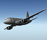
After my initial work on the Project airbus A318 (V1.2) and on the project Airbus A319 (A319 Special Version V2), I present my special version of the Project Airbus A318 Version 2, which includes many improvements and new features.
The instrument panel has been adapted of the Stefan Liebe work, on which I have added many changes. I created a vertical navigation gauge (VNAV gauge) which manages automatically the climb of the aircraft like a FMC (it can be work in several stage), with pre-programmed data according the weight of the aircraft and the altitude. The autopilot is constant MACH, with a transition altitude of 25000ft, thus avoiding the risk of overspeed. The ND will display information page in real time on the flight plan, an information page on the destination airport and display the radar map of the terrain, with AI traffic in real time.
All instruments are active in the VC and 2D panel. The instruments were completed by a multitude of small details. I have improved the autolanding function, with a soft landing (rounded). There is a complete operating manual in PDF format, in English and in French. Of course, TOGA mode and Autobrake mode works. Only compatible with FSX SP2 or Acceleration. See the readme file and the user manual for information and copyright. This version is also a big upgrade on the A318 special version 1.0 and 1.2. This is not an update, but a new aircraft. Francois Dore.
| Filename: | Airbus_A318_FD_Special_Version_V2.zip |
| License: | Freeware, limited distribution |
| Added: | 6th April 2012, 19:59:27 |
| Downloads: | 11,992 |
| Author: | Francois Dore, Project Airbus, Stefan Liebe |
| Size: | 134.71 MB |
| Category: Flight Simulator 2004 - Scenery | |
| Masbate Airport, Masbate, Philippines |
|
File Description:
This is a totally new Masbate Scenery Addon for Flight Simulator 2004. This features Multi-Level of Detail (MLOD) which makes a scenery framerate-friendly. At a distance, the objects are on its LOW POLYGON STATE. And while you get closer and closer, the objects become more and more complex, making you landing sequence unaffected by heavy framerate hit due to the High number of Polygons of the Library Objects.
In this scenery, you will see a total transformation from the default Masbate City area in FS2004 to a new realistic and alive Masbate City as seen in the included screenshots.
Masbate Airport Scenery (RPVJ) features photorealistic textures. This includes the Main Terminal Building, the Rancho Cuervo Verde Hangar, the Masbate Airport cargo warehouse, the Administration Building, the Crash and Fire Rescue Station, and the Control Tower. This scenery has full night lighting textures and has night lighting beams that illuminate the ramp from the firestation building. Other library objects included are: Animated Baggage Carts, Airport and Ramp personnel, ferry boats, ships, yachts, sailboats, cargo vessels, lighthouse, jeeps, cows and horses. But these objects do not interfere with the framerate so much because this is defined in the MLOD feature.This scenery has not been tested with FS2002 but is more likely to work without problem in that version except that AFCAD for FS2002 should be separately designed.
Currently, Asian Spirit serves this destination daily from Manila arriving at 7:15 a.m. and departing for Manila at 7:35 a.m.
| Filename: | Masbate_Airport_Masbate_Philippines.zip |
| License: | Freeware |
| Added: | 29th June 2004, 02:55:36 |
| Downloads: | 4,247 |
| Author: | Ver Walter Gulfan, Philippine Flightsimmers Group |
| Size: | 4.09 MB |
| Category: Flight Simulator X - Miscellaneous Files | |
| Boeing 737NGX Checklist |
|
Images related to this file:
File Description:
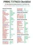
There are already some great checklists for the PMDG NGX done by others but what I've found with these checklists is that I find them to include many steps that I normally don't perform on every single flight, things like testing all fire bells and whistles etc.
So for this reason I decided to first setup the cockpit in a cold & dark state which corresponds to how the flightdeck should look like for every single switch in the cockpit according to the Boeing doc that came with the NGX after running both the shutdown and secure flows and then from this state make a checklist including all the phases of the flight from preflight at the origin to securing the a/c at the destination.
Since I'm doing all my flying online I have also included items such as filing your flightplan, asking ATC for push and engine startup clearence etc. Not fully realistic to include those kind of items in a checklist but the main purpose of this checklist will be to serve as a memory note how to perform a correct flight online in the NGX. Being used to the company of a FS2Crew FO this checklist will be there to help not forgetting about any steps during all the phases of the flight.
If you just like me have been looking for a simple checklist that will help you remember all the normal steps performed on a normal flight I hope you'll enjoy this checklist!
| Filename: | Boeing_737NGX_Checklist.zip |
| License: | Freeware |
| Added: | 18th September 2011, 17:40:11 |
| Downloads: | 8,492 |
| Author: | Richard Asberg |
| Size: | 37.91 KB |
| Category: Flight Simulator 2004 - Gauges | |
| FS2004 GPS Map View Gauge v3.0 |
|
File Description:
The ultimate gauge. The Map will show: Airports details (Runways ID's, length & ILS), VOR's and NDB's frequencies,
Intersections and waypoints, Airspaces, Approaches and flight routes. You can toggle the view
you require for your flight. Also you can zoom in/out to see the nearest airports, vor's and
ndb's. The map will indicate A/C heading flightplan title and waypoints ID's.
Version 3 includes more enhancements such as the ability to input the ICAO code or name of any airport and the map will
show all the frequencies of that airport including ATIS, ILS, AND COM. In addition, the map will show the active
runway designations, length and width.
You can also input ICAO code of any VOR/NDB and the map will show their frequencies.
There was a bug in v2.0, in which if you enter ( click on ENT )the ICAO code of an airport, you will lose the flight
plan loaded. Now you can go back to the flight plan and with the NEXT/PREV buttons you have the choice of where to start
your FP.
The gauge will show Flight Plan Title, originating and destination airports, active waypoint, waypoint index and FP
crusing altitude.
I addition, the gauge will show various useful information, such as, Runway IDs, lenght, width and approach magnetic heading,
Airport name, city, and type. NAV1/2 names, codes, distances and ETA's, ADF1/2 names and codes.
Finally, the gaugee will show other information, such as, magvar, indicated airspeed, mach, ground velocity, ambient
wind velocity and direction, bank angle , and a/c altitude ( radio height ).
All the information above and much more on a single gauge window.
| Filename: | FS2004_GPS_Map_View_Gauge_v30.zip |
| License: | Freeware, limited distribution |
| Added: | 14th September 2005, 14:19:46 |
| Downloads: | 10,843 |
| Author: | Talal Alhaj |
| Size: | 710.05 KB |
| Category: Flight Simulator X - Scenery | |
| LGSM Samos International Airport, Greece |
|
Images related to this file:
File Description:
LGSM Samos International Airport, Greece.
The island of Samos lies in the Eastern Aegean and is a very popular tourist destination for flights from Berlin, Munich, Gatwick, Oslo, Copenhagen, Rome and many others. It is widely regarded as the most dangerous airport in Greece, mountainous terrain requires a sharp right hand turn onto runway 09 and landings are invariably subject to strong turbulence.
The airport has been designed to sit on the excellent photoreal scenery by Dimitris Ntaskas, which is available here on Avsim and called 'samos_305814.zip'. It also uses many objects from my lgkf_kefallinia.zip scenery also available here at Avsim. The scenery has been designed for and tested with DX9 and FSXA only, if used with the default terrain many objects will be misplaced.
The scenery features a very detailed airport, repositioned according to satellite imagery and is based on real photographs. Full night lighting is included with washed lighting of the apron and carparks. The nearby town of Pythagorio has been modelled and includes some local landmarks. I have included many autogen style buildings based on photographs of Samos and also autogen trees native to the region.
The airport includes many animations, including olive trees, flags, people, windsocks, birds, road traffic and waves. Local Air traffic between the neighbouring islands of Chios, Mykonos, Kos and Rhodes is included, as is a panoramic view from inside the new tower. All the files have been sub-divided and can be switched on or off according to user preference.
Full installation instructions, settings, hints and tips can be found in the readme file. Please enjoy and I hope you like my scenery as much as I enjoyed building it.
| Filename: | LGSM_Samos_International_Airport_Greece.zip |
| License: | Freeware, limited distribution |
| Added: | 27th February 2013, 02:45:01 |
| Downloads: | 23,203 |
| Author: | George Keogh |
| Size: | 47.62 MB |
| Category: Flight Simulator 2004 - Aircraft Repaints, Textures and Modifications | |
| Pacific Western AI Aardvark Boeing 737-200 |
|
File Description:
Pacific Western, repaint for the AI_Aardvark 737-200. By RotorRick Deckard. Freeware, textures only, requires AI_Aardvark 737-200 basepack.
Pacific Western was a Canadian airline based in the western provinces, back when I was growing up, and I saw their planes all the time. They merged into CP Air, which turned into Canadian Airlines when they also took Wardair. And Canadian Airlines exists no longer either, having been absorbed by Air Canada, many of their staff were let go, and less desirable planes sold off to discount airlines.
Pacific Western, in parnership with Boeing, pionered a modification to the 737-200 that enabled it to land on gravel runways! Yes, no joke, with several of the destination runways up near the arctic circle, these runways wouldn't survive the ground temperature changes if they were more common paved or concrete runways. Anyway, I don't know many details, but I do know it involved a large beaver board attached to the rear of the nosegear wheels (which looks very much like that on the Antarctic mission C-130's the US uses to support missions down under), and vortex generators to blow in front of the engines on landing. This is all done to keep the low slung engines from ingesting any FOD. Since that time, such strips are more commonly visited by the Boeing 727, which has it's engines better protected and is generally more suited to such special purposes.
See here for more info:
http://airlines.afriqonline.com/airlines/205.htm
http://www.airtimes.com/cgat/ca/pwa.htm
This airline has operated the 707, Lockheed C-130 Hercules (actually L-100 variant), 767-200 and many other planes, but they were always primarily a 737-200 based airline.
| Filename: | Pacific_Western_AI_Aardvark_Boeing_737200.zip |
| License: | Freeware |
| Added: | 21st May 2005, 00:41:43 |
| Downloads: | 732 |
| Author: | Rick Deckard |
| Size: | 596.88 KB |
| Category: Prepar3D V1-4 - Utilities | |
| GENav pro Navigation |
|
Images related to this file:
File Description:

Previous payware product at SimMarket, now 100% free.
With GENav pro you will view all AIRAC navigation data and terminal procedures inside Google Earth. GENav pro run under Windows and require only Google Earth for displaying. You can also edit your own routes or just copy routes into GENav to view in Google Earth. You can search for example an airport or a fix by short or long name, Google Earth will take you there.
You can connect to Microsoft Flight Simulator to view your aircraft. Moving map and heading is available.
GENav pro is highly optimized for best performance and clear views without clutter. There are smart filters to select relevant data to display, all AIRAC items are available. You will find all data such as nav-aid frequencies, airport runways with ILS frequencies by click the displayed icons in Google Earth.
You can edit routes visual direct inside Google Earth by click. The database can always be updated with Navigraph's latest AIRAC data.
With GENav you can easy build valid routes. Unlike other common autorouting program, GENav is the tool for you to build routes with correct airway direction and correct connected to SID/STAR's. You will easy draw your routes most stright and correct to destination. It is also excellent for visual and instrument navigation flights.
FEATURES:
*** Display airports, nav aids, waypoints
*** Display High/Low airways and airways direction
*** Display SID/STAR, Approaches and Transitions
*** Display ARTCC/FIR border
*** AIRAC data available by click
*** Search airport and fixes
*** AIRAC data compatible Navigraph data
*** Visual editable routes
*** VOR to VOR route navigation data
*** Display your aircraft
BASIC SYSTEM REQUIREMENTS:
*** Windows with Google Earth installed
( Notice, no flightsim program required )
OPTIONALLY REQUIREMENTS:
*** SID/STAR require the Navigraph purchase or an alternative free source
*** Airways direction & high/low info require the Navigraph purchase
*** To display aircraft, Microsoft Flight Simulator or Prepare3D v1/v2, with free FSUIPC is required.
*** To display aircraft at a separate computer, also the payware WideFS is required.
| Filename: | GENav_pro_Navigation.zip |
| License: | Freeware |
| Added: | 25th May 2016, 11:24:52 |
| Downloads: | 654 |
| Author: | Lennart Vedin |
| Size: | 4.5 MB |
| Category: Flight Simulator 2004 - Utilities | |
| GENav pro Navigation |
|
Images related to this file:
File Description:

Previous payware product at SimMarket, now 100% free.
With GENav pro you will view all AIRAC navigation data and terminal procedures inside Google Earth. GENav pro run under Windows and require only Google Earth for displaying. You can also edit your own routes or just copy routes into GENav to view in Google Earth. You can search for example an airport or a fix by short or long name, Google Earth will take you there.
You can connect to Microsoft Flight Simulator to view your aircraft. Moving map and heading is available.
GENav pro is highly optimized for best performance and clear views without clutter. There are smart filters to select relevant data to display, all AIRAC items are available. You will find all data such as nav-aid frequencies, airport runways with ILS frequencies by click the displayed icons in Google Earth.
You can edit routes visual direct inside Google Earth by click. The database can always be updated with Navigraph's latest AIRAC data.
With GENav you can easy build valid routes. Unlike other common autorouting program, GENav is the tool for you to build routes with correct airway direction and correct connected to SID/STAR's. You will easy draw your routes most stright and correct to destination. It is also excellent for visual and instrument navigation flights.
FEATURES:
*** Display airports, nav aids, waypoints
*** Display High/Low airways and airways direction
*** Display SID/STAR, Approaches and Transitions
*** Display ARTCC/FIR border
*** AIRAC data available by click
*** Search airport and fixes
*** AIRAC data compatible Navigraph data
*** Visual editable routes
*** VOR to VOR route navigation data
*** Display your aircraft
BASIC SYSTEM REQUIREMENTS:
*** Windows with Google Earth installed
( Notice, no flightsim program required )
OPTIONALLY REQUIREMENTS:
*** SID/STAR require the Navigraph purchase or an alternative free source
*** Airways direction & high/low info require the Navigraph purchase
*** To display aircraft, Microsoft Flight Simulator or Prepare3D v1/v2, with free FSUIPC is required.
*** To display aircraft at a separate computer, also the payware WideFS is required.
| Filename: | GENav_pro_Navigation.zip |
| License: | Freeware |
| Added: | 25th May 2016, 11:24:32 |
| Downloads: | 531 |
| Author: | Lennart Vedin |
| Size: | 4.5 MB |
| Category: Flight Simulator 2002 - Scenery | |
| Caticlan-Boracay Version 2003 |
|
File Description:
Caticlan Airport is located in Malay, Aklan, northwest of the island of Panay, Philippines.
Boracay Island ,meanwhile, is the internationally known tourist spot destination for travellers and vacationers worldwide for its COOL WHITE SANDY BEACHES. Caticlan Airport is the gateway to BORACAY ISLAND due to its close proximity to the island resorts. Today,Asian Spirit serves the MANILA-CATICLAN route with a total of 9 flights daily,and the CEBU-CATICLAN route with a total of 2 flights daily. Southeast Asian Airlines (SEAIR) also serves Caticlan with 10 flights daily from Manila and 1 flight daily from Cebu. Other smaller airline companies also serve the Manila-Caticlan route such as Pacific Air.
This CATICLAN-BORACAY SCENERY features the most real replicas of structures in Caticlan airport.It features the Godofredo P. Ramos Airport Terminal building, Air Transportation Office and Pacific Air Terminal Building, Crash and Fire Rescue Station, Old Caticlan Control Tower, Pactrans Building, Asian Spirit Departure Lounge, Alice in Wonderland, the new Caticlan Control Tower Complex, Duty Free Philippines-Caticlan and the Caticlan Pier area.
Boracay Island also features different aqua sports activities in most realistic forms such as Jetskiing, Windsurfing, Banana Boating, Parasailing, Catamaran Sailing, Birds Watching, Girls Watching, and a static volleyball tournament along the White Beach area. Also featured in Boracay Island are the following resorts: FRIDAY'S BEACH RESORT, CLUB PANOLY BEACH RESORT, WILLY'S ROCK BEACH RESORT and LORENZO SOUTH BEACH RESORT. Shipping Companies are also featured in the nearby vicinity of the Boracay Oceans such as WG&A SUPERFERRY2, CEBU FERRIES and SULPICIO LINES' PRINCESS OF THE UNIVERSE.
Caticlan-Boracay Scenery Version 2003 is developed for FS2002 by Ver Walter L. Gulfan and the Philippine Flightsimmers Group, with the aim of helping promote the Boracay Island and Philippine Tourism. (A Caticlan-Boracay Scenery version for FS2004 will be released soon).
Inclusions in this release: 1. RPVE afcad file 2. RPVE scenery.cfg file 3. RPVE TTools airports.cfg file 4. RPVE and Caticlan VCPMOD file for Editvoicepack.
| Filename: | CaticlanBoracay_Version_2003.zip |
| License: | Freeware |
| Added: | 20th August 2003, 17:43:24 |
| Downloads: | 2,864 |
| Author: | Ver Walter L. Gulfan/ Philippine FlightSimmers Group |
| Size: | 10.17 MB |
| Category: Flight Simulator X - Utilities | |
| GENav pro Navigation |
|
Images related to this file:
File Description:

Previous payware product at SimMarket, now 100% free.
With GENav pro you will view all AIRAC navigation data and terminal procedures inside Google Earth. GENav pro run under Windows and require only Google Earth for displaying. You can also edit your own routes or just copy routes into GENav to view in Google Earth. You can search for example an airport or a fix by short or long name, Google Earth will take you there.
You can connect to Microsoft Flight Simulator to view your aircraft. Moving map and heading is available.
GENav pro is highly optimized for best performance and clear views without clutter. There are smart filters to select relevant data to display, all AIRAC items are available. You will find all data such as nav-aid frequencies, airport runways with ILS frequencies by click the displayed icons in Google Earth.
You can edit routes visual direct inside Google Earth by click. The database can always be updated with Navigraph's latest AIRAC data.
With GENav you can easy build valid routes. Unlike other common autorouting program, GENav is the tool for you to build routes with correct airway direction and correct connected to SID/STAR's. You will easy draw your routes most straight and correct to destination. It is also excellent for visual and instrument navigation flights.
FEATURES:
*** Display airports, nav aids, waypoints
*** Display High/Low airways and airways direction
*** Display SID/STAR, Approaches and Transitions
*** Display ARTCC/FIR border
*** AIRAC data available by click
*** Search airport and fixes
*** AIRAC data compatible Navigraph data
*** Visual editable routes
*** VOR to VOR route navigation data
*** Display your aircraft
BASIC SYSTEM REQUIREMENTS:
*** Windows with Google Earth installed
( Notice, no flightsim program required )
OPTIONALLY REQUIREMENTS:
*** SID/STAR require the Navigraph purchase or an alternative free source
*** Airways direction & high/low info require the Navigraph purchase
*** To display aircraft, Microsoft Flight Simulator or Prepare3D v1/v2, with free FSUIPC is required
*** To display aircraft at a separate computer, also the payware WideFS is required
| Filename: | GENav_pro_Navigation.zip |
| License: | Freeware |
| Added: | 23rd May 2016, 19:57:35 |
| Downloads: | 1,577 |
| Author: | Lennart Vedin |
| Size: | 4.5 MB |


© 2001-2026 AVSIM Online
All Rights Reserved
Privacy Policy |