
Where Flight Simulation Enthusiasts Gather from Around the World!
AVSIM Library - Search Results

| Category: Flight Simulator 2004 - Original Aircraft | |
| B-26K (A-26A) Counter-Invader |

|
File Description:
In the early 1960's, meeting the need for a "counter-insurgency" aircraft, the USAF chosen On Mark Engineering Company of Van Nuys, California proposed the following major modifications to the already existing B-26 airframe: a complete remanufacture of the fuselage and tail assembly, an enlarged rudder, rebuilt and strengthened wings, re-engining with 2,500 hp P&W R-2800-52W engines, larger, fully reversible propellers with automatic feathering and clipped tips, full dual flight controls, two 165 gallon wing tip tanks, a full compliment of airborne electronics and more. This new aircraft was first delivered to the USAF in June of 1964 under the designation B-26K. Later aircraft had their cowlings revised with the air scoop being relocated further back on the cowl. By April of 1965, all forty B-26K Counter-Invaders had been delivered to the USAF.
For all effects, gauges, and the excellent A-26 sound package by David Copley, the original SOH A-26 Invader is required to be installed before installation of this aircraft. Included in this package: model by Milton Shupe with K model modifications by John Terrell, textures by Russel Smith, Henry William, and John Terrell, 2D panel and gauges by Rich Murray, flight dynamics by Jerry Beckwith and Tom Falley modified by John Terrell, pilot figures by Jan Visser. A special thanks goes out to Milton Shupe who generously provided me the original source model to work with as well as a great amount of help whenever I ran into a tough spot. Also I'd like to thank Cliff Presley for all of his excellent resources he has provided to this project.
| Filename: | B26K_A26A_CounterInvader.zip |
| License: | Freeware |
| Added: | 27th April 2007, 23:33:37 |
| Downloads: | 7,645 |
| Author: | John Terrell |
| Size: | 14.54 MB |
| Category: Flight Simulator X - Scenery | |
| RAF Swanton Morley - Norfolk, England |
|
File Description:
Swanton Morley was a new station planned under the RAF expansion scheme but not completed to the same standard before the start of the Second World War. It was part of No. 2 Group in Bomber Command until December 1944 when it was given over to 100 Group - the RAF unit responsible for countering German defences against the British strategic bombing - as they needed another airfield close to their HQ at Bylaugh Hall.
On 4 July 1942, American and British airmen took off from this station as part of the first combined bombing raid of World War II. No 226 Squadron had been tutoring the US 15 Bombardment Squadron. Both Winston Churchill and General Eisenhower were at RAF Swanton Morley for this mission, which saw six crews from 15th Bombardment Squadron fly a raid with six crews from the RAF, using Boston light bombers belonging to No. 226 Squadron RAF. The raid was made at low level against German airfields in the Netherlands. During World War II the station was home to the Bomber Support Development Unit (BSDU) of No. 100 Group RAF.
After World War II the station was home to No 1 Air Signaller's School and later to the Central Servicing Development Establishment (CSDE) and the Maintenance Analysis and Computing Establishment (MACE).
From June 1953 to 1995 the station was also used by 611 Volunteer Gliding School, when the station was listed for closure under Options for Change. The station held popular airshows during the 1980s. The station closed in 1995 and was converted to an Army base now known as Robertson Barracks. Source: Wikipedia.
| Filename: | RAF_Swanton_Morley__Norfolk_England.zip |
| License: | Freeware |
| Added: | 29th January 2016, 12:26:24 |
| Downloads: | 268 |
| Author: | Terry Boissel |
| Size: | 1.06 MB |
| Category: Flight Simulator X - Scenery | |
| Ridge Soaring 79N Julian PA |
|
Images related to this file:
File Description:
Ridge Soaring Gliderport (79N) is a public-use glider airport located two nautical miles (4 km) southwest of the central business district of Unionville, in Centre County, Pennsylvania, United States. It is privately owned by Knauff & Grove, Inc. Tom Knauff and Doris grove are among the whos who in American and International soaring community.
Portions of the 1999 movie The Thomas Crown Affair were filmed here.
Co-owner Thomas L. Knauff set five FAI world records, and over 50 NAA national records flying from this airport.
Co-owner Doris Grove set three FAI feminine world records flying from this airport, and was the first woman to fly a glider more than 1000 km.
This FBO airport is world famous for ridge, thermal and wave soaring. It is located on U.S. Route 220 (alternate) 8 miles south of Interstate 80, between Unionville and Julian, at the base of the Bald Eagle Mountain ridge. It is approximately 10 miles from State College and approximately midway between Altoona and Lock Haven in the Bald Eagle Valley. Visitors can look at an entire wall of U.S. National and World records that have been set from this airfield.
Sadly as with so many small airports, Ridge Soaring is in risk of disappearing. for sale for many years, with no takers it may be sold to developers and disappear forever.
In FSX the airport was on the wrong side of the highway and cut into a mountain, I moved it to its proper location and heading, made the runway the correct size and heading, and added all the current buildings.
| Filename: | Ridge_Soaring_79N_Julian_PA.zip |
| License: | Freeware |
| Added: | 11th June 2014, 16:24:59 |
| Downloads: | 292 |
| Author: | Jon Davidson |
| Size: | 16.52 MB |
| Category: Flight Simulator 2004 - Original Aircraft | |
| Piaggio P-166CL2 |
|
File Description:
Thanks to Andrew Spring of www.p166.com!!
The fifth of the coming P-166 aircraft series. I'm going to build the whole family of these graceful twins.
This file covers the whole production line of the P-166CL2!!! (Well, just 2...(-:)
The Piaggio P-166A is a light small twin. An Exotic two-engined prop that sold all over the world including America, UK, and Australia. he P-166CL2 was developed to take advantage of the cabin spaciousness of the P-166 series: a new landing gear that retracts under the fuselage into two small blisters lets expand the internal useful area more bakwards between the wings, as there is no central section. This lets the P-166CL2 accomodate 12 poassengers + pilot. The old gear bays at the side of te fuselage were replaced with two large windows that give a strange top-down view for the passenger. Tiptanks are optionally unattachable, as using them plus 12 passengers makes the plane go overweight. Means that the 12 passengers can only be transported on a considerabily short range. Only 2 P-166CL2s were built, due to the low-range caused by the small old-type tiptanks and the unstability of the new landing gear, that gave serious problems while taxiing. The P-166C is dated October '64, and converted to CL2 in 1972. The aircraft is still in production in a slightly modified turboprop version, the P-166D-P1. This model is 760 Kbs with c.a. 23000 polygons in c.a.170 assemblies. Features Clickable Dynamic VC with non-planar throttle quadrant. Detailed internals. Fully compatible with FS 2002 (pro edition)
| Filename: | Piaggio_P166CL2.zip |
| License: | Freeware |
| Added: | 4th April 2004, 18:02:21 |
| Downloads: | 5,617 |
| Author: | Mario Noriega |
| Size: | 7.23 MB |
| Category: Flight Simulator 2004 - Scenery | |
| Gjoa Haven CYHK, on King William Island, Nunavut, Canada, |
|
Images related to this file:
File Description:
Gjoa Haven is a village of 1,200 or so inhabitants at N 68 38 W 95 51 on the southeast corner of King William Island, around 155 miles north of the Arctic Circle. It's Inuit name is Uqsuqtuuq; the Gjoa Haven name was given by the Norwegian explorer Roald Amundsen when he spent two years there from 1903 to 1905 during his exploration of the northwest passage from east to west. His boat was called Gjoa and the cove was named Gjoa Harbour, in Norwegian. The village has been added in this scenery with approximately the right shape; though the coastline with Ultimate Terrain does have the small cove that serves as a harbor the coast shape is wrong. The airfield runway is 4,400 feet of gravel 100 feet wide at 154 feet above sea level. There is no LL100 available, only JetA1, delivered once a year by ship along with all the other requirements of the town. There is also a nearby CAM-B remotely operated defence radar station with its three protective domes. The old terminal building is still there, albeit repainted and spruced up, along with the far larger and newer one alongside it.
One of the screen shots shows Gjoa Haven as it appears for at least 8 months of the year, with snow on the ground and sea ice all around. If you want the ice then download my recent post of All Canada frozen lakes, rivers, and the northern seas, reversible with an untick in the FS scenery library.
| Filename: | Gjoa_Haven_CYHK_on_King_William_Island_Nunavut_Can.zip |
| License: | Freeware, limited distribution |
| Added: | 19th February 2011, 15:42:51 |
| Downloads: | 550 |
| Author: | Roger Wensley |
| Size: | 2.68 MB |
| Category: Flight Simulator 2004 - Scenery | |
| VFR of Lario, Area E2 - Como Lake, Italy (Update) |
|
Images related to this file:
File Description:
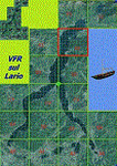
This 8th scenery covers approximately an area of 7.5x6 km, from S.Gregorio/Dongo (NW) to Colico (NE), and S.Siro (SW) to Tremenico/Aveno (SE) and includes six NLC piers: Dervio, Piona, Colico, Dongo, Musso, Pianello del Lario, in addition to the disused Cremia's one; a lot of dedicated buildings are included, as S.Tommaso of Canterbury church and fortification (Corenno), Cistercian abbey (Piona), pier and dock (Colico), S.Stefano church, factory buildings and airpollution control machinery (Dongo), Rezzonico's castle (S.Siro).
This VFR on Lario scenery includes several Dervio's details, and fully revises the previous Dervio scenery; Are included: Boldona's park office and stand, railway station, NLC shiphard, Pontile piers with Concordia steamer, dock bay with small floating pier and compass of the lake, S. Peter and Paul church and houses front of lake, hydro power station, Municipality and some other buildings, Castello's tower, windsurf school, windsurfers and kitesurfers on the lake, cross and Madonna on top of Legnoncino mountain. There are also included two viaducts between the tunnels of the freeway 36, with moted traffic. Catamarans Citta di Como and Tivano at Colico/Dongo piers together with other minor boats and docks alongside the lake coast; a moted regata with catamarans is placed in the lake between Pianello and Dervio.
This scenery SUPERSEDES AND CANCELS the previous "dervio_v2a" one, removed from the library. This is the eighth scenery of the "VFR of Lario" project, made with photorealistic terrain (multiseason & night) and with some 3D GMax realistic objects.
| Filename: | VFR_of_Lario_Area_E2__Como_Lake_Italy_Update.zip |
| License: | Freeware |
| Added: | 25th November 2012, 20:54:39 |
| Downloads: | 1,664 |
| Author: | Aldo Della Vedova, Daniele Lanfranchi, Gian Mario Verga |
| Size: | 39.39 MB |
| Category: Flight Simulator 2004 - Scenery | |
| PAIW Wales, Alaska, USA |
|
Images related to this file:
File Description:
Googly scenery for Wales - a small domestic airport on the western coast of Alaska that is poorly provided for in Flight Simulator 2004. These scenery files add taxiways, aprons, buildings and other airport features, so that you and your "AI" traffic can land, taxi, park and take off in a realistic manner.
Wales is a small village with a population of just over 150 people, so the facilities at this 4000 foot gravel airstrip are fairly limited. The airport is allocated the ICAO code PAIW, although Microsoft has ignored this in Flight Simulator and uses the IATA ticket code IWK. Wales is served by light aircraft from airlines such as Bering Air, Cape Smythe Air, Frontier Flying Service, and Hageland Aviation Services. You might find it a convenient stopping-off point for a quick trip across to Russia - this is about as close as you can get and a nip across the Bering Strait will find you there in no time.
The scenery does not purport to be ultra-accurate. Based on high-detail satellite imagery from Google Earth, the layout is proportionally correct but the added airport features, such as buildings, are built from default Microsoft objects and add-on libraries so will not look like the real thing.
You are not obliged to download and install any additional scenery libraries, but to enjoy this scenery in its entirety, you may wish to. It will work fine, with or without.
[File re-uploaded at request of AVSIM]
| Filename: | PAIW_Wales_Alaska_USA.zip |
| License: | Freeware |
| Added: | 26th June 2010, 13:51:45 |
| Downloads: | 1,266 |
| Author: | John Hinson |
| Size: | 76.81 KB |
| Category: Flight Simulator X - Aircraft Repaints, Textures and Modifications | |
| Douglas C-47 (VH-AGU) Adastra Aerial Surveys |
|
Images related to this file:
File Description:
This folder contains a repaint for version 3.14 of the Douglas C-47 by Manfred Jahn and colleagues in the colors of C-47 VH-AGU of Adastra Aerial Surveys. It was originally constructed for the USAAF in 1944 as a C-47B-35-DK and allocated the military serial 44-76336. In February 1945 it was acquired by the RAAF and allocated the serial A65-72. Operated until 1959, it was then sold to Adastra Airways and converted for civil use. In October 1964 the aircraft was re-registered to Sepal Pty Ltd, but in October 1969 it was acquired by Adastra Aerial Surveys Pty Ltd. Adastra Aerial Surveys was acquired by East-West Airlines Ltd in April 1973 and VH-AGU was re-registered to East-West Airlines on 12 November 1974. East-West won the MLS trials support contract in December 1974 and VH-AGU was re-painted in East-West colours at Tamworth in the month prior to positioning at Melbourne/Essendon for the commencement of the contract on 25 January 1975. At some stage in the late 1970s the aircraft was transferred to South Coast Aviation, another East-West subsidiary. The aircraft was withdrawn from service in August 1979 at Essendon at the conclusion of its Departmental charter, and sold to Aerodyne Pty Ltd of Moorabbin. Since then, it has had several owners, and is still airworthy, flying in a USAF Vietnam war scheme from Morwell, Victoria. Repaint by Jan Kees Blom for Manfred Jahn's C-47 version 3.14, based on the paintkit by Gman5250.
| Filename: | Douglas_C47_VHAGU_Adastra_Aerial_Surveys.zip |
| License: | Freeware |
| Added: | 22nd August 2018, 15:12:21 |
| Downloads: | 192 |
| Author: | Jan Kees Blom |
| Size: | 15.68 MB |
| Category: Flight Simulator X - Scenery | |
| Whale Island (Hi Resolution Photo and mesh), New Zealand |
|
Images related to this file:
File Description:
Whale Island (Maori Name: Moutohora) is a small island located off the Bay of Plenty coast of New Zealand's North Island. It is located about 12 kilometers north of the town of Whakatane. A whaling station existed on the island during the 19th century. The 1.43 km island is a remnant of a complex volcano which has eroded, leaving two peaks. This is still an area of volcanic activity and there are hot springs on the island in Sulphur Valley, McEwans Bay, and Sulphur Bay.
This Hi Resolution scenery was created from a 0.25m pixel resolution Ortho-rectified Aerial mosaic owned by Environment Bay of Plenty (The Bay of Plenty Regional Council) and flown in 2007. The imagery has been slightly de-sampled for use in Flight Simulator X and utilizes the a custom hi resolution 5m Mesh derived from photogrammetry data off the photos. The textures are intended for summer daylight flying only, although due to the evergreen nature of New Zealand's native bush, the Islands appearance remains relatively constant throughout the year.
The island contains a small helicopter pad which is used for checking the various radio antennas on the Island. There is also a small Department of Conservation hut near the south western tip of the Island. These objects have been added from the FSX library of objects. Make sure to turn up your graphics sliders to make the most of this data! To find the Island fly north from Whakatane airport.
| Filename: | Whale_Island_Hi_Resolution_Photo_and_mesh_New_Zeal.zip |
| License: | Freeware, limited distribution |
| Added: | 20th January 2010, 10:12:14 |
| Downloads: | 4,650 |
| Author: | Tim Barnes |
| Size: | 9.94 MB |
| Category: Flight Simulator 2004 - Scenery | |
| Deering PADE in Alaska |
|
Images related to this file:
File Description:
Deering is a coastal village around 55 miles southwest of Kotzebue, living from fishing and the land and with a population of around 130. The airfield is inland from the coast and has two gravel runways, 11-29 of just under 3,000 feet and 2-20 of 3,700 feet; the US is the only country that names runways with single numerals, hence 2-20 that in Canada would be 02-20. And Canada, which is a metric country and gives speed limits on roads in kilometres per hour, flies in feet and not metres for runway lengths and flight levels. The two runways could have something to do with there being a National Guard Armoury in the village, and perhaps personnel being flown in for exercises in the local countryside. Apart from the airfield itself, and it's buildings, this scenery modifies the local (mostly treeless) land class, reduces the village size to reality, and creates a new airfield background. Bering Air flies into Deering from Kotzebue and is included in the AI. A note here about my scenery making. This is post number 504 and there will not be many more to follow this as I am almost at the end of the photos I either took or found for scenery purposes. There is a limit to what can be located online and I have already been making use of the little there is; eg Unalakleet. So, if you are near an airport (preferably Canadian or Alaskan) and have a camera..... Let me know.
| Filename: | Deering_PADE_in_Alaska.zip |
| License: | Freeware, limited distribution |
| Added: | 7th August 2019, 16:37:12 |
| Downloads: | 137 |
| Author: | Roger Wensley |
| Size: | 4.32 MB |
© 2001-2026 AVSIM Online
All Rights Reserved
Privacy Policy |