
Where Flight Simulation Enthusiasts Gather from Around the World!
AVSIM Library - Search Results

| Category: Flight Simulator X - Scenery | |
| California Central Coast Scenery for FSX with Megascenery Earth (Default Mesh Terrain) |

|
Images related to this file:
File Description:
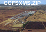
Revised 1/7/10 for upload to Avsim.COM. CCFSXMSFix is incorporated so not required.
This is an earlier version of CCC Megascenery Earth scenery that doesn't require FSGenesis Mesh Terrain. See CCFSXMSG.ZIP for the FSGenesis Mesh version.
This scenery covers the California coastal region from N36���°10' (Coalinga) to N34���°25' (Santa Barbara) and from the coast East to W119���°40'. It is a version of my previous California Central Coast scenery redesigned and expanded to work with MegaScenery Earth from PC Aviator Inc. Many airstrips in the area covered by this scenery have been added or enhanced for a total of 27 airports/airstrips in the area. Several areas of interest such as the Santa Barbara marina, Morro Bay, etc. are also included for a total of 41 points of interest. All airports/airstrips and related structures have been adjusted and realigned to conform to actual positions and dimensions as indicated by the MegaScenery satellite textures. In addition, there are 6 invisible water runways for use by AI floatplane traffic. MegaScenery California-13, -14 and -15 are required for this scenery to make sense. I also used California-12, -28 and -29 when constructing the scenery but they could be considered optional.
| Filename: | California_Central_Coast_Scenery_for_FSX_with_Mega.zip |
| License: | Freeware |
| Added: | 7th January 2010, 21:28:45 |
| Downloads: | 1,561 |
| Author: | Al Wheeler |
| Size: | 8.12 MB |
| Category: Flight Simulator X - Scenery | |
| Ota Air Base |
|
File Description:
The Ota Air Base (BA2), created on December 31, 1937, was inaugurated on April 14, 1940, near the town of Ota, about 50KM from Lisbon (Portugal). Lodged aircraft such as Gloster Gladiator, Junkers JU-52, Junkers JU-86, Hawker Hurricane and Supermarine Spitfire. In 1953 are received the first jet aircraft of FAP, two De Havilland Vampire and the first 25 planes Republic F-84 G Thunderjet, making BA2 the most important Air Force Base until the end of the 1950s. In 1960 the BA2 changed radically, no longer a basis for an Operational Base Instruction. In November 1976 was created the Centro de Instrucao 2 (CI2), for elementary education pilot (with DHC Chipmunk), radar experts and the integration of training schools and military preparation technique. In 1992 the designation of Air Base 2 is amended to Centro de Formacao Militar e Tecnica da Forca Aerea (CFMTFA) which gives the training military, humanistic, scientific and technical staff of the Air Force, whose scope is not covered by other organs of the Air Force, with the aerodrome is currently closed to air activity. This scenery was the fact that it has in the FS aircraft that operated in Ota, such as the DHC Chipmunk, the Republic F-84G or the Junkers Ju-52. This scenary was made in ADE9X. Tested in FSX, I do not know if it works in FS2004.
| Filename: | Ota_Air_Base.zip |
| License: | Freeware |
| Added: | 8th December 2009, 01:09:33 |
| Downloads: | 1,852 |
| Author: | Jorge Ferreira |
| Size: | 1.35 MB |
| Category: Prepar3D V5 - AFCAD Files | |
| KMEM (Memphis Intl.) bgl/afcad for Prepar3D v5 |
|
File Description:
This is a modification of the stock Memphis afcad/bgl in Prepar3d v5 and models the airport in its state prior to the new construction occurring presently at the main terminal area. For ease of use and simplicity, gates are numbered "Gate A1, Gate A2", etc...
I tried to match as closely as possible the FedEx Terminal as close to what was shown on current Navigraph charts but it is NOT exact.
Airport Breakdown:
Passenger Terminal w/ airline codes have been added to gates.
- Concourse A: Gates 1-8
- Concourse B: Gates 1-24
- Concourse C: Gates 1-8
- FedEx Terminal - Dock numbering is based loosely on the dock numbers found on the Navigraph charts for KMEM. Not all docks are represented but there 120 spaces for parking there.
- FedEx Maintenance - Is on the East side of the airport below runway 27. It has 16 static parking areas.
- Northwest FBO - Located West of runway 18C. It has 18 parking spots.
- Northeast FBO - Located East of Runway 18C to the left of the FedEx Maint. area. It has 14 parking spots.
- South Cargo - Located next to Runway 36R. It has 5 parking spots (I am assuming UPS and other carriers).
- Military Ramp - Located next to South Cargo next to Runway 36R. It has 5 parking spots.
I hope you enjoy this enhancement of KMEM
| Filename: | KMEM_Memphis_Intl_bglafcad_for_Prepar3D_v5.zip |
| License: | Freeware |
| Added: | 28th November 2023, 01:47:55 |
| Downloads: | 67 |
| Author: | Michael Johnson |
| Size: | 47.2 KB |
| Category: Flight Simulator X - Aircraft Repaints, Textures and Modifications | |
| Asiana Airlines B777-200ER (PW) (HL7500) **UPDATE ** |
|
Images related to this file:
File Description:

REPAINT UPDATED FOR - new Captain Sim v1.0 folders, improved wear pattern on wings, correction to engine paint issues, converted to Pratt & Whitney engines.
This is a repaint of a Boeing 777-200ER, registration code HL7500, operated by Asiana Airlines, operated by Asiana Airlines, one of South Korea's two major airlines, along with Korean Air. Asiana has its headquarters in Asiana Town in Osoe-dong, Gangseo-gu, Seoul. The airline has its domestic hub at Gimpo International Airport and its international hub at Incheon International Airport. Asiana is a member of the Star Alliance and offers 516 daily departures throughout Asia, Europe, North America, and Oceania, operating 14 domestic and 85 international passenger routes and 20 cargo routes. Asiana currently operates eleven Boeing 777-200ER aircraft.
This repaint has plenty of clear markings so if you enjoy exterior detail, then you will love this repaint. You can see (and read): Door opening instructions; Static port directions; Air vent warnings; Engine hazard area; No Step warnings; RAT caution; APU intake warning; Stabilizer compartment access; Ground power supply; Forward and aft access door instructions; Pitot, ADA probe, Ice detector and TAT probe markings; Visible rivets; Enhanced window frames; Authentic Asiana logo; Bold, colorful Asiana livery and authentic flags; Lovely Asiana flight attendant; No frame rate hit.
To use this repaint, the Captain Sim B777-200 v1.0 is required. Repainted by Garrett Rowley, [email protected]
| Filename: | Asiana_Airlines_B777200ER_PW___HL7500__UPDATE_.zip |
| License: | Freeware |
| Added: | 27th February 2013, 14:36:54 |
| Downloads: | 4,176 |
| Author: | Garrett Rowley, Captain Sim |
| Size: | 30.12 MB |
| Category: Flight Simulator 2004 - Utilities | |
| Software Development Kits (SDK) pack |
|
Images related to this file:
File Description:
This file contains all of the Software Development Kits released years ago by Microsoft for Flight Simulator 2004: A Century of Flight (FS9). These were released for developers and enthusiasts who want to customize and create add-ons for FS9.
Included are:
1. Autogen SDK - autogen_sdk_setup.exe (5.4MB);
2. Netpipes SDK - netpipes_sdk_setup.exe (545KB);
3. Terrain SDK - terrain_sdk_setup.exe (11MB);
4. Weather Themes SDK - weather_theme_sdk_setup.exe ( 3.7MB);
5. Panels and Gauges SDK - panels_sdk_setup.exe (1.6MB);
6. Traffic Toolbox SDK - traffictoolbox_sdk_setup.exe (1.5MB);
7. ABL - fs2004_sdk_abl_setup.exe (611KB);
8. Aircraft Container SDK - fs2004_sdk_aircraft_container_setup.exe (609KB);
9. ATC Voicepack SDK - fs2004_sdk_atc_voicepack_setup.exe (17.9MB);
10. FSEdit SDK - fs2004_sdk_fsedit_setup.exe (1.3MB);
[also inclued is a version for Japanese FS9 Users: fs2004_sdk_fsedit_japan_setup.exe (1.1MB)];
11. Multiplayer and Flight Instructor SDK - fs2004_sdk_multiplayer_setup.exe (524KB);
12. Make Model SDK - makemdl_sdk_setup.exe (1.1MB);
13. BGLComp SDK - fs2004_sdk_bglcomp2_setup.exe (857KB);
14. gmax Gamepack SDK - fs2004_sdk_gmax_setup.exe (15.5MB);
15. Special Effects SDK - fs2004_sdk_special_effects_setup.exe (693KB);
16. Cabdir SDK - cabdir_sdk_setup.exe (559KB).
Although portions of the SDK may prove useful to Flight Simulator enthusiasts with little or no programming experience, keep in mind that many parts of the SDK assume familiarity with XML, the C programming language, and game development.
Please note: The information in the SDKs is NOT supported by Microsoft Product Support. No support is available for these SDK files!
| Filename: | Software_Development_Kits_SDK_pack.zip |
| License: | Freeware |
| Added: | 22nd August 2012, 20:25:47 |
| Downloads: | 3,624 |
| Author: | Microsoft Corporation, Uploaded by AVSIM |
| Size: | 59.22 MB |
| Category: Prepar3D V1-4 - Aircraft Repaints, Textures and Modifications | |
| Pan Am L-049 Constellation |
|
Images related to this file:
File Description:

Pan American World Airways livery for the A2A COTS L049 Constellation. These textures will also work in FSX.
Pan American World Airways, known from its founding until 1950 as Pan American Airways[1] and commonly known as Pan Am, was the principal and largest international air carrier in the United States from 1927 until its collapse on December 4, 1991. Founded in 1927 as a scheduled air mail and passenger service operating between Key West, Florida, and Havana, Cuba, the airline became a major company credited with many innovations that shaped the international airline industry, including the widespread use of jet aircraft, jumbo jets, and computerized reservation systems. It was also a founding member of the International Air Transport Association (IATA), the global airline industry association.[3] Identified by its blue globe logo ("The Blue Meatball"), the use of the word "Clipper" in aircraft names and call signs, and the white pilot uniform caps, the airline was a cultural icon of the 20th century. In an era dominated by flag carriers that were wholly or majority government-owned, it was also the unofficial overseas flag carrier of the United States. During most of the jet era, Pan Am's flagship terminal was the Worldport located at John F. Kennedy International Airport in New York City.(Source: Wikipedia)
All logos and texts had to be recreated, since there was nothing usable on the net.
| Filename: | Pan_Am_L049_Constellation.zip |
| License: | Freeware, limited distribution |
| Added: | 6th January 2017, 08:29:29 |
| Downloads: | 1,175 |
| Author: | Eberhard Haberkorn / A2A |
| Size: | 65.23 MB |
| Category: Flight Simulator X - Scenery | |
| North Central Ecuador v3, including SEQM (SEQU) and SEIB |
|
Images related to this file:
File Description:
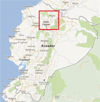
FSX/P3D Version 3 of this scenery is a completely new build of SEQM from the ground up. The entire complex is rendered using FSX objects along with the new highway that connects to the highway infrastructure with AI road traffic. The airport is now at a mean altitude that better blends with the newly included NASA SRTM GL1 30m mesh for the region. The tower is at the correct altitude. Buildings use more accurate footprints, new models, floating jetways, and updated landclass, and work seamlessly with the roads added by FTX Global/Vector. Lakes are corrected within roughly 100 square miles. Although the Ibarra/Atahualpa (SEIB) airport no longer exists, there is an option to add it back. Startup files are included to fly from the lakes and the Ibarra/Atahualpa (SEIB) airport. As a “bonusâ€, SEQU was restored in this version, because much of the footprint of the airport still remains as part of its conversion to a park. As such, a custom and fully functional SEQU is included for users who would like to revisit the old airport. AI Traffic can be restored at SEQU by simply using the "Reversed SEQU-SEQM AI Traffic" option. Scenery was created using Airport Design Editor X v1.76.6715, SBuilderX 3.13, and the FSX Object Placement Tool. Scenery objects were added and modified from stock FSX scenery to resemble as closely as possible the actual airport. Bill Leaming's Ramp Lights for P3D/FSX illuminate the aprons.
| Filename: | North_Central_Ecuador_v3_including_SEQM_SEQU_and_S.zip |
| License: | Freeware |
| Added: | 22nd March 2020, 22:13:37 |
| Downloads: | 4,129 |
| Author: | Carlyle Sharpe |
| Size: | 29.44 MB |
| Category: Flight Simulator X - AFCAD Files | |
| Atlantic City International Airport (KACY), NJ |
|
File Description:
Located 09 miles NW of Atlantic City, New Jersey on 5000 acres of land, Atlantic City International Airport is a major airport serving the southern portion of New Jersey. It is also one of the main gateways for tourists looking to vacation in nearby Atlantic City, famous for its boardwalks and casinos. This airport has been very heavily modeled with many surrounding buildings and all aprons properly placed. Gates are all properly located and labeled according to the terminal chart (there are, however, no jetways like in the default scenery). General Aviation parking is available in its proper area � all aircraft in the parking area (middle of the tarmac) have collision disabled. If you select Military Cargo parking you will start on one of the helipads in the Coast Guard section. If you select Military Combat parking you will start next to the line of F-16s on ready-alert over on the Air National Guard tarmac. You can also start on a helipad north of the airport. This airport also features completely custom taxiway line and edge lighting. Because this airport uses ATC, it suffers the same bug as my KEWR airport, which is that you cannot receive taxi in directions from ATC � to gate, parking or fuel. Almost all arriving AI aircraft will also disappear from the taxiway after radioing in to ATC and failing to receive taxi instructions to the gate/parking. All traffic and instructions taxiing out works fine. All gate parking spaces have fuel, as well as the military parking and north helipad. GA aircraft can get fuel by taxiing over to the fuel station north of the GA tarmac. Taxiing onto a closed runway (marked with an �X�) will cause a crash. Broken-down taxiways are not good for your undercarriage!
Scenery constructed with use of satellite images/streetview/aerial photos - the author has not been there in person.
This scenery is meant to be used in conjunction with MegaScenery Earth New Jersey/Delaware 003. It is not required, but apron use is minimized to allow satellite scenery to show through as much as possible, and objects are placed based on the MSE textures - lack of it may make scenery look out of place.
| Filename: | Atlantic_City_International_Airport_KACY_NJ.zip |
| License: | Freeware |
| Added: | 1st February 2011, 10:28:53 |
| Downloads: | 1,355 |
| Author: | Drew Sikora |
| Size: | 5.12 MB |
| Category: Flight Simulator 2004 - Scenery | |
| Valdez Pioneer Field PAVD in Alaska |
|
Images related to this file:
File Description:
Pioneer Field is in Valdez Alaska, between the mountains to the north and the water of Valdez Arm to the south. It used to cater for a lot of the work for the Alaskan pipline and the nearby terminal and in the middle 1970's it was a very busy place. That is not the case now, and the tower is no longer manned though there is still an average of 35 flights a day and there are 30 planes (and helicopters) based at the field. There are three really odd hangars at the western end of the apron, with each of them having 6 "T" hangars which have been joined in a circle; this is the only place I have ever seen this. The recently resurfaced runway is 6,500 feet of 150 feet wide asphalt aligned 6/24 at 121 feet asl. There is also a wide and heavy duty asphalt and gravel surrounding runoff and base, probably because of drainage problems with water from the mountains. Fuel (both JetA and 100LL) is available from ERA Helicopters at the eastern end of the apron. All of the buildings on the field have been modelled specifically for this scenery, plus the nearby accomodation blocks. The AI flights are for the twice-daily ERA/Alaska Air flights using a Bombardier Dash 8-200.
| Filename: | Valdez_Pioneer_Field_PAVD_in_Alaska.zip |
| License: | Freeware, limited distribution |
| Added: | 21st January 2011, 03:29:51 |
| Downloads: | 1,201 |
| Author: | Roger Wensley |
| Size: | 3.97 MB |
| Category: Flight Simulator X - AFCAD Files | |
| Ekdahl Airport (NJ59), NJ |
|
File Description:
Located 04 miles S of Freehold, New Jersey, Ekdahl Airport is a private turf strip 1300' in length bordered closely by trees. This makes for an interesting landing as the 90' width of the runway is all the room you have to play with. However because it can be difficult to gauge your distance to trees and also because even the slightest brush with a tree can cause a crash, all trees immediately adjacent to the runway have crash disabled - mainly so you can turn your plane around if you land on Runway 02. The hard surface runway was removed so make sure your terrain mesh complexity is set as high as possible to get that bumpy ground realism. A windsock is listed as being available on this field but I could not locate it in any imagery and so placed it by default near the hangar building. You can start on the runways or parked in front of the hangar. Make sure your plane is capable of these take off and landing distances! Tree height around the field was not listed so I again used my best judgement from studying aerial photos. There is no fuel or parking for transient aircraft available. The field is not lit - daytime VFR operations only are recommended.
Scenery constructed with use of satellite images/streetview/aerial photos - the author has not been there in person.
This scenery is meant to be used in conjunction with MegaScenery Earth New Jersey/Delaware 002. It is not required, but apron use is minimized to allow satellite scenery to show through as much as possible, and objects are placed based on the MSE textures - lack of it may make scenery look out of place.
| Filename: | Ekdahl_Airport_NJ59_NJ.zip |
| License: | Freeware |
| Added: | 13th August 2011, 16:53:55 |
| Downloads: | 172 |
| Author: | Drew Sikora |
| Size: | 550.03 KB |


© 2001-2026 AVSIM Online
All Rights Reserved
Privacy Policy |