
Where Flight Simulation Enthusiasts Gather from Around the World!
AVSIM Library - Search Results

| Category: Flight Simulator 2002 - Utilities | |
| Tu-134 Paint Kit (Paint Shop Pro) |

|
File Description:
Paint Shop Pro Multilayered Texture Paint Kit for Tupolev Tu-134 by George Sukhykh. My first repaints of this fine aircraft were terrible, so with some big help from George Sukhykh and Bob Koendering, I have developed this new paint kit for George's original texture files. Contains the four base texture files, and some brief instructions for use; should convert nicely in Photoshop, too. Original aircraft and textures by George Sukhykh (required to fly), PSP conversion by Michael Pearson.
| Filename: | Tu134_Paint_Kit_Paint_Shop_Pro.zip |
| License: | Freeware, limited distribution |
| Added: | 31st January 2003, 13:51:40 |
| Downloads: | 634 |
| Author: | George Sukhykh / Michael Pearson |
| Size: | 2.22 MB |
| Category: Flight Simulator 2004 - AI Aircraft | |
| ExpressMed Aircraft Inventory |
|
File Description:
Three fictional Air Transports, the F90, B200 and the Gates Lear 25.
for AI or actual flying. With some window config changes.
Plus
Two Long Range Medical Transports and Air Ambulances for long range one - the B1900c by Beechcraft 1900C by Henry Tomkiewicz and the ERJ170 conversion by Aardvark E- it also includes the USAir texture and FDE by Koji Tanaka and David Carter.
Repainted and modified window config. Both great for AI and are flyable.
[email protected]
| Filename: | ExpressMed_Aircraft_Inventory.zip |
| License: | Freeware |
| Added: | 25th May 2005, 13:06:28 |
| Downloads: | 617 |
| Author: | Henry Tomkiewicz,Dee Waldron, AIAardvark, Dale Caruso |
| Size: | 3.6 MB |
| Category: Flight Simulator X - Aircraft Repaints, Textures and Modifications | |
| FEDEX Fokker F27-600 (I-FEAB) |
|
Images related to this file:
File Description:
The Fokker F27 cargo version was derived from the conversion of the F27-200/400 with large cargo door, was the series 600 called QC MODE, the Quick Change(QC) concept describes the ability to convert a passenger aeroplane to a freighter and vice versa in a short space of time. I have configured as F27-300 having the same forward cargo door.
*** Texture only, requires the payware Just Flight Fokker F27 Friendship 100/200/300 ***
| Filename: | FEDEX_Fokker_F27600_IFEAB.zip |
| License: | Freeware |
| Added: | 11th September 2017, 22:36:22 |
| Downloads: | 302 |
| Author: | Roberto Fusi |
| Size: | 3.83 MB |
| Category: Flight Simulator 2004 - Scenery | |
| Spain & Portugal Mesh 2004 |
|
File Description:
This scenery cover entire Spain, Portugal and south France till E005. This scenery is compatible with my Italian mesh 2004 scenery.
Based on SRTM 3 arc.sec data.
Unfortunately SRTM DATA have many holes and data loss, so I made a resampling and an oversampling with other data with lower resolution, but with better coverege with geo cad software like Grass and GlobalMapper for projection convertion.
Compression and conversion to bgl with MS Flight simulator SDK at LOD 9
| Filename: | Spain__Portugal_Mesh_2004.zip |
| License: | Freeware |
| Added: | 17th November 2003, 17:04:23 |
| Downloads: | 34,284 |
| Author: | Pietro Mauri |
| Size: | 92.79 MB |
| Category: Flight Simulator X - Scenery | |
| RAF Dalton |
|
File Description:
RAF Dalton was named after a local village although it was closer to RAF Topcliffe who it was intended to be the
satellite for.
RAF Dalton was home to No. 102 Squadron beginning in November 1941. No. 102 Squadron returned to Topcliffe in June
1942 and for a time Dalton hosted No. 1652 Heavy Conversion Unit (HCU) flying Halifaxes. The airfield was improved in
1942 and in early 1943 was allocated to No. 6 Group Royal Canadian Air Force (RCAF). Canadian squadrons stationed
here at one time or another included No. 428 Squadron, No. 424 Squadron, No. 420 Squadron, and No. 1666 Heavy
Conversion Unit (which moved to RAF Wombleton in October 1943). The station also housed no. 1691 Bomber Gunnery Flight
(BGF) RCAF and its successor, No. 1695 Bomber Defence Training Flight (BDTF) RCAF, the last RCAF unit to serve at this
station.
In November 1944, control passed from No. 6 Group to the new No. 7 (Training) Group. By August 1945 all units at
Dalton were disbanded or transferred and the Station closed in 1946.
Source:Wikipedia
| Filename: | RAF_Dalton.zip |
| License: | Freeware |
| Added: | 26th February 2017, 07:30:47 |
| Downloads: | 80 |
| Author: | Terry Boissel |
| Size: | 1.57 MB |
| Category: Flight Simulator 2004 - AI Aircraft | |
| AI Spirit of Panalpina B744-8F Operated by Atlas Air |
|
Images related to this file:
File Description:

"Spirit of Panalpina" B744-8F Operated by Atlas Air.
Panalpina is a Swiss company, provider of forwarding and logistics services, specializing in intercontinental air and ocean freight and associated supply chain management solutions. In addition, Panalpina has a cooperating agreement with cargo airline Atlas Air Cargo, which in turn has one Boeing 747 named "Spirit of Panalpina".
Flightplans may be available on AVSIM or FlightSim.com.
This works for both FS9 and FSX. Tested in FSX.
Texture quality; FSX Native: DDS DXT5 with alpha. FS9 Native: BMP DXT3 with alpha.
FSX Light Fix included in the DDS night texture.
Included repaint is for the following model:
AIA_747_400F :: model.fge_no_refl
Model is available on AVSIM and FlightSim.com or on the author/developers site. (aia747fb.zip)
You need the basekit for this to work!!
Do make sure you copy the texture folder(s) in the respective folder.
Note: This is a AIA 742F GE / AIA 747-400F conversion for the 744F GE model, though the new Panalpina is actually a 744-8F heavy bird unfortunately there is no such model available thus the conversion.
Enjoy
| Filename: | AI_Spirit_of_Panalpina_B7448F_Operated_by_Atlas_Ai.zip |
| License: | Freeware, limited distribution |
| Added: | 25th June 2012, 05:18:23 |
| Downloads: | 812 |
| Author: | Stephan Faessler / ImpulseAI |
| Size: | 1.5 MB |
| Category: Flight Simulator 2002 - Original Aircraft | |
| Aerostar S700 'Spirit of Kai Tak' |
|
File Description:
The Aerostar Super 700 is the World's fastest piston twin
aircraft. The "Spirit of Kai Tak" competed in and won the
London to Sydney Air Race in March/April 2001.
This FS2000 & FS2002 only computer model performs similar to
the real aircraft and also has a custom cockpit panel which I
have designed (thanks to Harald Scheidl for the Yoke gauge, which
I have modified for the Aerostar Yoke). I designed the panel using
CFG Edit and the aircraft using Abacus FS Design Studio Pro and
Aircraft Animator. There are many animated parts, including a
steerable nose wheel, spoilers and it also has an illuminating
landing light beam. Also included is a very good Piper 350 engine
sound package (Author Unknown).
| Filename: | Aerostar_S700_Spirit_of_Kai_Tak.zip |
| License: | Freeware, limited distribution |
| Added: | 24th November 2002, 04:57:07 |
| Downloads: | 6,683 |
| Author: | Mark Dickinson |
| Size: | 4.44 MB |
| Category: Flight Simulator 2004 - Aircraft Repaints, Textures and Modifications | |
| Republic P47D-10-RE "Herky" |
|
Images related to this file:
File Description:
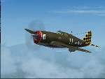
Wings of Power P-47D-10-RE 42-103324 "Herky" flown by Major Herschel "Herky" Green,commander of the 317th Fighter Squadron from 25 March to 23 September 1944.This plane downs 6 Axis aircrafts (four Ju-52,one Ma-202 and one Do-217) in one day over Northern Italy on January 30, 1944.Requires prior purchase/installation of Wings of Power P-47 Thunderbolt pack available at www.a2asimulations.com
| Filename: | Republic_P47D10RE_Herky.zip |
| License: | Freeware |
| Added: | 3rd August 2010, 08:10:04 |
| Downloads: | 586 |
| Author: | Stephan Pillon - A2A Simulations |
| Size: | 5.49 MB |
| Category: Combat Flight Simulator 1 and 2 - Aircraft | |
| CFS2/FS9 Republic P-47D-11-RE Thunderbolt Razorback 42-75510/HV-A |
|
Images related to this file:
File Description:
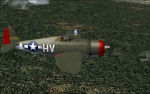
Re-upload. CFS2/FS9 Republic P-47D-11-RE Thunderbolt Razorback 42-75510/HV-A. This aircraft was flown by Maj. Francis S. Gabreski (top 8th AF ace with 28 victories). Major Gabrewski commanded the 61st FS. 56th FG, 1943. This repaint is for the ALPHASIM model which can be found at: http://www.alphasim3.com/store/advanced_search_result.php?keywords=P-47&x=7&y=9 . Repaint by Evan G. Butterbrodt (revev). Enjoy!
| Filename: | CFS2FS9_Republic_P47D11RE_Thunderbolt_Razorback_42.zip |
| License: | Freeware |
| Added: | 28th May 2010, 02:45:27 |
| Downloads: | 91 |
| Author: | Evan G. Butterbrodt |
| Size: | 1.25 MB |
| Category: Flight Simulator 2002 - Miscellaneous Files | |
| Manual/Checklist Douglas R4D-6 NATS |
|
File Description:
The Manual/Checklist describes all neccessary settings and operations for the Douglas R4D-6 NATS (DC-3/C-47) by the design team Jan Visser, Roy Chaffin, Bill Rambow, Erik Ellis, Brian Withers and Eric Mitchell, starting with a "dark and cold" panel/engine. From Pre Start - Startup - Before Taxi - Taxi - Before Takeoff - Takeoff - Climb Out - Cruise - Descent - Approach - Landing - Taxi To Ramp - Shutdown - Securing Aircraft - to "cold".
| Filename: | ManualChecklist__Douglas_R4D6_NATS.zip |
| License: | Freeware |
| Added: | 17th July 2003, 15:08:21 |
| Downloads: | 932 |
| Author: | Werner Schott |
| Size: | 697.3 KB |


© 2001-2026 AVSIM Online
All Rights Reserved
Privacy Policy |