
Where Flight Simulation Enthusiasts Gather from Around the World!
AVSIM Library - Search Results

| Category: Flight Simulator 2004 - Scenery | |
| "Himalayan Peaks" LOD10 Mesh, Volume 3 - Namcha Barwa |

|
File Description:
Highly detailed terrain mesh of the Namcha Barwa area, N29°-31° E94°-96°. The files in this package are based on Shuttle Radar (SRTM) Version 2 data but with many of the void areas, especially the most significant sections, filled with elevation data generated from topographic maps by Jonathan de Ferranti. While Jonathan's work is unrelated to flight simulation he kindly gave me permission to compile his data for use in FS. The result is a wonderful improvement in detail and accuracy over any existing mesh file, freeware or commercial, based on SRTM or DTED data alone. Due to the large area of the Himalayas I've compiled the source data as two separate series: the "Himalayan Peaks" series covers prominent mountains and ranges in higher detail and locally overrides any existing LOD9 terrain mesh. In addition, a LOD9 "base mesh" series covering the entire Himalayas will be available for those who do not yet have an add-on terrain mesh of these beautiful mountains.
| Filename: | Himalayan_Peaks_LOD10_Mesh_Volume_3__Namcha_Barwa.zip |
| License: | Freeware, limited distribution |
| Added: | 18th February 2006, 23:15:17 |
| Downloads: | 12,195 |
| Author: | Holger Sandmann and Jonathan de Ferranti |
| Size: | 15.09 MB |
| Category: Flight Simulator 2004 - Scenery | |
| "Himalayan Peaks" LOD10 Mesh, Volume 4 - Annapurna |
|
Images related to this file:
File Description:
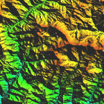
Highly detailed terrain mesh of the Annapurna area, N28-30 E83-85. The files in this package are based on Shuttle Radar (SRTM) Version 2 data but with many of the void areas, especially the most significant sections, filled with elevation data generated from topographic maps by Jonathan de Ferranti. While Jonathan's work is unrelated to flight simulation he kindly gave me permission to compile his data for use in FS. The result is a wonderful improvement in detail and accuracy over any existing mesh file, freeware or commercial, based on SRTM or DTED data alone.
Due to the large area of the Himalayas I've compiled the source data as two separate series: the "Himalayan Peaks" series covers prominent mountains and ranges in higher detail and locally overrides any existing LOD9 terrain mesh. In addition, a LOD9 "base mesh" series covering the entire Himalayas will be available for those who do not yet have an add-on terrain mesh of these beautiful mountains.
| Filename: | Himalayan_Peaks_LOD10_Mesh_Volume_4__Annapurna.zip |
| License: | Freeware, limited distribution |
| Added: | 29th May 2010, 08:59:29 |
| Downloads: | 10,470 |
| Author: | Holger Sandmann, Jonathan de Ferranti |
| Size: | 15.07 MB |
| Category: Flight Simulator 2004 - Scenery | |
| "Himalayan Peaks" LOD10 Mesh, Volume 5 - Garhwal |
|
File Description:
Highly detailed terrain mesh of the Garhwal area, N30°-32° E78°-81°. The files in this package are based on Shuttle Radar (SRTM) Version 2 data but with many of the void areas, especially the most significant sections, filled with elevation data generated from topographic maps by Jonathan de Ferranti. While Jonathan's work is unrelated to flight simulation he kindly gave me permission to compile his data for use in FS. The result is a wonderful improvement in detail and accuracy over any existing mesh file, freeware or commercial, based on SRTM or DTED data alone. Due to the large area of the Himalayas I've compiled the source data as two separate series: the "Himalayan Peaks" series covers prominent mountains and ranges in higher detail and locally overrides any existing LOD9 terrain mesh. In addition, a LOD9 "base mesh" series covering the entire Himalayas will be available for those who do not yet have an add-on terrain mesh of these beautiful mountains.
| Filename: | Himalayan_Peaks_LOD10_Mesh_Volume_5__Garhwal.zip |
| License: | Freeware, limited distribution |
| Added: | 18th February 2006, 23:16:47 |
| Downloads: | 10,141 |
| Author: | Holger Sandmann and Jonathan de Ferranti |
| Size: | 27.72 MB |
| Category: Flight Simulator 2004 - Scenery | |
| "Himalayan Peaks" LOD10 Mesh, Volume 6 - Jammu and Kashmir |
|
Images related to this file:
File Description:
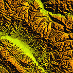
Highly detailed terrain mesh of the Jammu and Kashmir areas, N31-36 E76-78. The files in this package are based on Shuttle Radar (SRTM) Version 2 data but with many of the void areas, especially the most significant sections, filled with elevation data generated from topographic maps by Jonathan de Ferranti. While Jonathan's work is unrelated to flight simulation he kindly gave me permission to compile his data for use in FS. The result is a wonderful improvement in detail and accuracy over any existing mesh file, freeware or commercial, based on SRTM or DTED data alone.
Due to the large area of the Himalayas I've compiled the source data as two separate series: the "Himalayan Peaks" series covers prominent mountains and ranges in higher detail and locally overrides any existing LOD9 terrain mesh. In addition, a LOD9 "base mesh" series covering the entire Himalayas will be available for those who do not yet have an add-on terrain mesh of these beautiful mountains.
| Filename: | Himalayan_Peaks_LOD10_Mesh_Volume_6__Jammu_and_Kas.zip |
| License: | Freeware, limited distribution |
| Added: | 29th May 2010, 08:55:43 |
| Downloads: | 9,675 |
| Author: | Holger Sandmann, Jonathan de Ferranti |
| Size: | 52.19 MB |
| Category: Flight Simulator 2004 - Scenery | |
| "Himalayan Peaks" LOD10 Mesh, Volume 7 - K2 and Karakoram |
|
Images related to this file:
File Description:
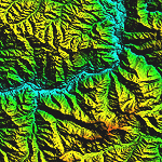
Highly detailed terrain mesh of the Karakoram area, N35-37 E73-77. The files in this package are based on Shuttle Radar (SRTM) Version 2 data but with many of the void areas, especially the most significant sections, filled with elevation data generated from topographic maps by Jonathan de Ferranti. While Jonathan's work is unrelated to flight simulation he kindly gave me permission to compile his data for use in FS. The result is a wonderful improvement in detail and accuracy over any existing mesh file, freeware or commercial, based on SRTM or DTED data alone.
Due to the large area of the Himalayas I've compiled the source data as two separate series: the "Himalayan Peaks" series covers prominent mountains and ranges in higher detail and locally overrides any existing LOD9 terrain mesh. In addition, a LOD9 "base mesh" series covering the entire Himalayas will be available for those who do not yet have an add-on terrain mesh of these beautiful mountains.
| Filename: | Himalayan_Peaks_LOD10_Mesh_Volume_7__K2_and_Karako.zip |
| License: | Freeware, limited distribution |
| Added: | 30th May 2010, 09:56:27 |
| Downloads: | 9,488 |
| Author: | Holger Sandmann, Jonathan de Ferranti |
| Size: | 38.58 MB |
| Category: Flight Simulator X - Aircraft Repaints, Textures and Modifications | |
| RAAF "75 Squadron" Dassault Mirage 2000 |
|
Images related to this file:
File Description:
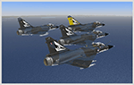
Four fictional Australian repaints for the Payware Metal-to-Mesh Mirage 2000 based off RAAF 75sqn Mirage IIIs.
| Filename: | RAAF_75_Squadron_Dassault_Mirage_2000.zip |
| License: | Freeware, limited distribution |
| Added: | 17th May 2015, 08:49:09 |
| Downloads: | 312 |
| Author: | Ben O'Donnell |
| Size: | 56.28 MB |
| Category: Fly! II - Scenery | |
| Loan und Logf mit Oe-ost Mesh |
|
File Description:
Doc File mit Tips für die Verwendung der Airports von Harald Kraft und der Oe-ost Mesh Scenery.
| Filename: | Loan_und_Logf_mit_Oeost_Mesh.zip |
| License: | Freeware |
| Added: | 30th July 2002, 21:51:53 |
| Downloads: | 151 |
| Author: | Helmut Mayer |
| Size: | 4.84 KB |
| Category: Flight Simulator 2004 - Scenery | |
| Mallorca, Ibiza, Menorca & Formentera Mesh |
|
File Description:
Containes the mesh for the 4 islands - processed by the SRTM global processor and sampled at 3 arcseconds.
| Filename: | Mallorca_Ibiza_Menorca__Formentera_Mesh.zip |
| License: | Freeware |
| Added: | 12th November 2003, 20:26:26 |
| Downloads: | 11,726 |
| Author: | Stefan Braunewell |
| Size: | 5.04 MB |
| Category: Flight Simulator 2002 - Scenery | |
| Venezuelan Andes 3-Arc Sec Terrain for FS2002 |
|
File Description:
This freeware add-on file will enhance your VFR Mountain flying experience with Microsoft FS2002. You will enjoy amazing elevation details for the Venezuelan Andes. Please see enclosed picture comparison with actual photograph and terrain mesh coverage. The terrain mesh was created using 3-Arc Second Digital Elevation Model (90 meters/pixel).
| Filename: | Venezuelan_Andes_3Arc_Sec_Terrain_for_FS2002.zip |
| License: | Freeware |
| Added: | 20th January 2023, 01:16:05 |
| Downloads: | 22 |
| Author: | P.Miliani |
| Size: | 3.72 MB |
| Category: Flight Simulator 2004 - Scenery | |
| Hungary and the Carpatians |
|
File Description:
This is a terrain mesh scenery for Hungary, the Carpatians, and for parts of the Transcarpathian territory. Based on SRTM Data (3 arc/sec), generated with Matthew Styles's program "SRTM To BGL v1.04", sampled to LOD9 resolution (76m) with 5 interpolation passes. While tested with Fs2002, this mesh should also run in FS2004.
| Filename: | Hungary_and_the_Carpatians.zip |
| License: | Freeware |
| Added: | 11th January 2004, 01:23:20 |
| Downloads: | 7,396 |
| Author: | Peter Papics |
| Size: | 66 MB |


© 2001-2026 AVSIM Online
All Rights Reserved
Privacy Policy |