
Where Flight Simulation Enthusiasts Gather from Around the World!
AVSIM Library - Search Results

| Category: Prepar3D V1-4 - Scenery | |
| P3D v4.3 Aeropuerto Internacional Alejandro Velasco Astete-PERU |

|
Images related to this file:
File Description:
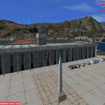
ONLY FOR P3D V4.3
REQUIRES ANY TERRAIN MESH
Alejandro Velasco Astete International Airport (IATA: CUZ, ICAO: SPZO) is an international airport located in the city of Cusco, in southeastern Peru. Cusco, a principal tourist attraction in Latin America, receives various domestic flights as well as some international flights. The runway is completely paved. It operates at limited capacity due to its precarious location near the city's center. Despite these limitations, the airport has consistently ranked as Peru's second most important air terminal, handling 3,209,153 national and international passengers in 2016, as reported by CORPAC.
| Filename: | P3D_v43_Aeropuerto_Internacional_Alejandro_Velasco.zip |
| License: | Freeware |
| Added: | 15th June 2019, 22:52:35 |
| Downloads: | 1,749 |
| Author: | Jhon Cristian |
| Size: | 115.91 MB |
| Category: Flight Simulator 2004 - Scenery | |
| Project Mexico Real LOD10 File 3 of 11 |
|
Images related to this file:
File Description:
Re-upload. File 3rd of 11 of a Terrain Mesh that covers the entirety of Mexican Territory and related bordering U.S., Guatemala and Belice areas, part of the "Proyecto Mexico Real" project, compiled at LOD10 (1.24 arcseconds in latitude and 1.65 arcseconds in longitude) resolution from INEGI data. Intended to enhance the virtual flying experience complementing the LOD8 and LOD9 versions compiled from the same data. Compatible backwards with Flight Simulator 2000, Flight Simulator 2002 and Combat Flight Simulator 2. Refer to the file contents about the cover area to this compressed file.
| Filename: | Project_Mexico_Real_LOD10_File_3_of_11.zip |
| License: | Check within download |
| Added: | 8th June 2010, 03:17:03 |
| Downloads: | 3,256 |
| Author: | Juan Jose Galvan Bautista |
| Size: | 73.67 MB |
| Category: Flight Simulator 2004 - Scenery | |
| Project México Real LOD10 File 4 of 11 |
|
File Description:
File 4th of 11 of a Terrain Mesh that covers the entire Mexican Territory and related areas bordering the U.S., Guatemala and Belice areas. Part of the "Proyecto México Real" project, compiled at LOD10 (1.24 arcseconds in latitude and 1.65 arcseconds in longitude) resolution from INEGI data. Intended to enhance the virtual flying experience complementing the LOD8 and LOD9 versions compiled from the same data. Compatible backwards with Flight Simulator 2000, Flight Simulator 2002 and Combat Flight Simulator 2. Refer to the file contents about the cover area to this compressed file.
| Filename: | Project_Mxico_Real_LOD10_File_4_of_11.zip |
| License: | Check within download |
| Added: | 6th June 2006, 00:58:59 |
| Downloads: | 3,068 |
| Author: | Juan José Galván Bautista |
| Size: | 74.49 MB |
| Category: Flight Simulator 2004 - Scenery | |
| Project México Real LOD10 File 6 of 11 |
|
File Description:
File 6th of 11 of a Terrain Mesh that covers the entire Mexican Territory and related areas bordering the U.S., Guatemala and Belice areas. Part of the "Proyecto México Real" project, compiled at LOD10 (1.24 arcseconds in latitude and 1.65 arcseconds in longitude) resolution from INEGI data. Intended to enhance the virtual flying experience complementing the LOD8 and LOD9 versions compiled from the same data. Compatible backwards with Flight Simulator 2000, Flight Simulator 2002 and Combat Flight Simulator 2. Refer to the file contents about the cover area to this compressed file.
| Filename: | Project_Mxico_Real_LOD10_File_6_of_11.zip |
| License: | Check within download |
| Added: | 6th June 2006, 01:07:16 |
| Downloads: | 3,025 |
| Author: | Juan José Galván Bautista |
| Size: | 71.63 MB |
| Category: Flight Simulator 2004 - Scenery | |
| Project Mexico Real LOD10 File 10 of 11 |
|
Images related to this file:
File Description:
Re-upload. File 10th of 11 of a Terrain Mesh that covers the entirety of Mexican Territory and related bordering U.S., Guatemala and Belice areas, part of the "Proyecto Mexico Real" project, compiled at LOD10 (1.24 arcseconds in latitude and 1.65 arcseconds in longitude) resolution from INEGI data. Intended to enhance the virtual flying experience complementing the LOD8 and LOD9 versions compiled from the same data. Compatible backwards with Flight Simulator 2000, Flight Simulator 2002 and Combat Flight Simulator 2. Refer to the file contents about the cover area to this compressed file.
| Filename: | Project_Mexico_Real_LOD10_File_10_of_11.zip |
| License: | Check within download |
| Added: | 5th September 2010, 20:55:05 |
| Downloads: | 3,063 |
| Author: | Juan Jose Galvan Bautista |
| Size: | 70.54 MB |
| Category: Flight Simulator 2004 - Scenery | |
| Project México Real LOD10 File 11 of 11 |
|
File Description:
File 11th of 11 of a Terrain Mesh that covers the entirety of Mexican Territory and related bordering U.S., Guatemala and Belice areas, part of the "Proyecto México Real" project, compiled at LOD10 (1.24 arcseconds in latitude and 1.65 arcseconds in longitude) resolution from INEGI data. Intended to enhance the virtual flying experience complementing the LOD8 and LOD9 versions compiled from the same data. Compatible backwards with Flight Simulator 2000, Flight Simulator 2002 and Combat Flight Simulator 2. Refer to the file contents about the cover area to this compressed file.
| Filename: | Project_Mxico_Real_LOD10_File_11_of_11.zip |
| License: | Check within download |
| Added: | 6th June 2006, 01:52:33 |
| Downloads: | 3,099 |
| Author: | Juan José Galván Bautista |
| Size: | 69.98 MB |
| Category: Navigation and ATC - Navigation | |
| LSZS - Samedan visual approach chart v3 |
|
Images related to this file:
File Description:
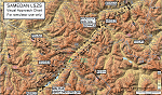
Custom made visual approach chart and pilot's briefing for Engadin (St. Moritz) Samedan LSZS airport in Switzerland, Europe's highest elevation airport (5,600 ft.) situated in the Swiss Alps. This airport is a day VFR operations only and has no instrument approach due to extreme terrain around it. A demanding visual descent into a canyon, in between steep rising terrain, is required to make the visual approaches for both runways with a steep 4.4* degrees final approach portion guided by the PAPI's. Still, executive jets up to Boeing 737(BBJ) size approach the airport often in the winter peak season VFR with these procedures. It is designed as per real operators' pilot briefing for Samedan. Real airport's full pilot briefing document also included. The real airport's excellent briefing (included) intentionally does not contain the maneuvers needed for the approach of jets through the mountains but only reporting points for all and maneuvers for light aircraft only. This gap is what this chart covers. Version 2 chart included better graphics and refined visual procedure for jets and version 3 now includes real pilot's briefing guide.
| Filename: | LSZS__Samedan_visual_approach_chart_v3.zip |
| License: | Freeware, limited distribution |
| Added: | 20th March 2015, 23:35:11 |
| Downloads: | 2,026 |
| Author: | Kyprianos Biris |
| Size: | 7.1 MB |
| Category: Flight Simulator X - Scenery | |
| LOSM Mauterndorf, Austria Version1 for FSX and P3D_v3/v4 |
|
Images related to this file:
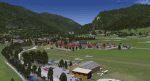
File Description: The Airfield Mauterndorf is the highest situated airfield in Austria: 3642 ft or 1110 meters above sealevel.
This Airfield is very common for glider flyers due to the usually good upwinds for flying in the alps. But also small engine aircrafts are approved. Link:
http://www.losm.at/index.php/losm.html The environment of the airfield is adapted by landclasses. Mauterndorf and the surrounding villages, valleys and major roads are included.
As well the field is covered by a photo background, wich includes four different images , each for one of the four seasons spring, summer, autum and winter. The buildings in this scenery are designed mainly new by myself, but also a lot of objects from two very popular freeware libraries.
If these libraries are not installed, many objects are not visible! The following libraries are used: 1. FS-Piloten_Objektlibrary:
http://www.fs-piloten.de/thread.php?threadid=10632 2.FSX_FlightPortLib:
http://www.flightport.de/libraries/flightport-library/ This senery works also with Austria Professional HD.
| Filename: | LOSM_Mauterndorf_Austria_Version1_for_FSX_and_P3D_.zip |
| License: | Freeware |
| Added: | 28th August 2017, 20:01:00 |
| Downloads: | 482 |
| Author: | Wolfgang Allers |
| Size: | 249.9 MB |
| Category: X-Plane - Scenery | |
| WXPJ Susi Air Puncak Jaya Mining Airstrip v1.0.0 |
|
Images related to this file:
File Description:
This is an X-Plane 11 scenery for Puncak Jaya Mining Airstrip (WXPJ) in the Puncak Jaya mountain region of Papua, Indonesia. This is a fictitious airfield, located in a high altitute mining location in Papua. At 4884 metres (16024 ft) above sea level, the Puncak Jaya peak, next to the mining location, is the highest mountain in Indonesia, on the island of New Guinea (which consists of the Indonesian West Papua region plus Papua New Guinea). This fictitious airfield may serve as a high altitute mining location challenge while flying the airstrips in Papua, as one of the destinations for "PT ASI Pujiastuti Aviation", operating as Susi Air, an Indonesia airlines established in late 2004 by Mrs. Susi Pudjiastuti. This scenery was tested and is operational (as of January 20, 2017) in "X-Plane 11 Public Beta #6 64 bit", Windows 10 Home. It was also tested and is partially operational (as of January 20, 2017) in "X-Plane 10.51 64 bit", Windows 10 Home. The issue with XP10 is the mesh again: there is no mine mesh, just a whole. The feel is very different from XP11, but it is still operational in XP10 to fly in and out.
| Filename: | WXPJ_Susi_Air_Puncak_Jaya_Mining_Airstrip_v100.zip |
| License: | Freeware |
| Added: | 21st January 2017, 18:42:35 |
| Downloads: | 58 |
| Author: | Rui Mesquita |
| Size: | 2.2 MB |
| Category: Flight Simulator 2004 - Scenery | |
| New York City Default Bridges and Objects v2.0 |
|
File Description:
I originally planned on "fixing" the George Washington Bridge, which was inadvertantly "sunk" by FSG's 38m mesh, and ended up repositioning and scaling a whole bunch of other default bridges and objects within about 50 miles of NYC. This addon was designed and tested for use with FS 9.1, FSG 38m mesh (available here at AVSIM), and Freeflow NE, UT/USA and USA Roads. It should also work with other road and water packages. I did not create any new scenery, I only repositioned default objects to their correct locations.
This should be the final version for a while. This version was tested with and adds compatibility for Megascenery NY and Aerosoft's Manhattan scenery. I also removed a few more objects that were placed in the water, and moved back to land a bunch of cranes around KEWR that were in the water.
Fixed stuff: All inappropriately placed NYC and Newark bridges (major, not autogen) up to Bear Mountain in the north and south to about the Verrazanno; Belmont Racing track; Shea Stadium; Meadowlands Stadium; World's Fair Tower; US Open Stadium. Added Meadowlands Race track and a few bridges around Newark, moved cranes around KEWR back to land, removed several objects in the water.
| Filename: | New_York_City_Default_Bridges_and_Objects_v20.zip |
| License: | Freeware |
| Added: | 10th November 2005, 16:48:46 |
| Downloads: | 6,562 |
| Author: | Thomas Perry |
| Size: | 558.69 KB |


© 2001-2026 AVSIM Online
All Rights Reserved
Privacy Policy |