
Where Flight Simulation Enthusiasts Gather from Around the World!
AVSIM Library - Search Results

| Category: Flight Simulator 2004 - Scenery | |
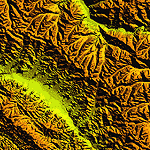
| "Himalayan Peaks" LOD10 Mesh, Volume 7 - K2 and Karakoram |

|
Images related to this file:
File Description:

Highly detailed terrain mesh of the Karakoram area, N35-37 E73-77. The files in this package are based on Shuttle Radar (SRTM) Version 2 data but with many of the void areas, especially the most significant sections, filled with elevation data generated from topographic maps by Jonathan de Ferranti. While Jonathan's work is unrelated to flight simulation he kindly gave me permission to compile his data for use in FS. The result is a wonderful improvement in detail and accuracy over any existing mesh file, freeware or commercial, based on SRTM or DTED data alone.
Due to the large area of the Himalayas I've compiled the source data as two separate series: the "Himalayan Peaks" series covers prominent mountains and ranges in higher detail and locally overrides any existing LOD9 terrain mesh. In addition, a LOD9 "base mesh" series covering the entire Himalayas will be available for those who do not yet have an add-on terrain mesh of these beautiful mountains.
| Filename: | Himalayan_Peaks_LOD10_Mesh_Volume_7__K2_and_Karako.zip |
| License: | Freeware, limited distribution |
| Added: | 30th May 2010, 09:56:27 |
| Downloads: | 9,473 |
| Author: | Holger Sandmann, Jonathan de Ferranti |
| Size: | 38.58 MB |
| Category: Flight Simulator 2004 - Scenery | |
| "Himalayan Peaks" LOD10 Mesh, Volume 6 - Jammu and Kashmir |
|
Images related to this file:
File Description:
Highly detailed terrain mesh of the Jammu and Kashmir areas, N31-36 E76-78. The files in this package are based on Shuttle Radar (SRTM) Version 2 data but with many of the void areas, especially the most significant sections, filled with elevation data generated from topographic maps by Jonathan de Ferranti. While Jonathan's work is unrelated to flight simulation he kindly gave me permission to compile his data for use in FS. The result is a wonderful improvement in detail and accuracy over any existing mesh file, freeware or commercial, based on SRTM or DTED data alone.
Due to the large area of the Himalayas I've compiled the source data as two separate series: the "Himalayan Peaks" series covers prominent mountains and ranges in higher detail and locally overrides any existing LOD9 terrain mesh. In addition, a LOD9 "base mesh" series covering the entire Himalayas will be available for those who do not yet have an add-on terrain mesh of these beautiful mountains.
| Filename: | Himalayan_Peaks_LOD10_Mesh_Volume_6__Jammu_and_Kas.zip |
| License: | Freeware, limited distribution |
| Added: | 29th May 2010, 08:55:43 |
| Downloads: | 9,661 |
| Author: | Holger Sandmann, Jonathan de Ferranti |
| Size: | 52.19 MB |
| Category: Flight Simulator 2004 - Original Aircraft | |
| Air Alps Dornier 328-110 |
|
File Description:
Dornier 328-110 in Air Alps colours. Features opening pax door and cargo door, flexing wings, dynamic shine and much more. Air Alps OE-LKE
| Filename: | Air_Alps_Dornier_328110.zip |
| License: | Freeware, limited distribution |
| Added: | 15th February 2004, 00:47:12 |
| Downloads: | 14,254 |
| Author: | Robert Versluys, Daniel Fall |
| Size: | 2.16 MB |
| Category: Flight Simulator X - Scenery | |
| FSX patch for Rio de Janeiro mesh |
|
File Description:
FSX brings as default a very good mesh for Rio de Janeiro City, showing the Sugar Loaf very detailed, in LOD 10. However, that mesh cover a limited area and changes its resolution to LOD 6, yet in a mountainous region. The consequences are visibles cuts in the relief, mainly in Paralel S22* 30'.
The solution we found was to compile the neighbours area at North, West and East, in LOD10 resolution changing to LOD 9, so to smooth the transition from those differents resolutions.
| Filename: | FSX_patch_for_Rio_de_Janeiro_mesh.zip |
| License: | Freeware |
| Added: | 19th April 2007, 03:05:38 |
| Downloads: | 8,370 |
| Author: | Jose Lobo and Oseas Dourado |
| Size: | 36.84 MB |
| Category: Flight Simulator 2004 - Scenery | |
| Lauterbrunnen LSXL |
|
File Description:
Scenery of the Air Glaciers heli base at Lauterbrunnen in the Bernese Oberland. The scenery contains Mönchsjochhütte, the highest refuge in the Bernese Alps, situated South of Mönch. The scenery has been designed in Gmax and optimized for the mesh of Switzerland Professional. In order to save system performance, a series of LODS have been created.
| Filename: | Lauterbrunnen_LSXL.zip |
| License: | Freeware |
| Added: | 13th July 2006, 02:58:06 |
| Downloads: | 3,535 |
| Author: | Michael Röthlisberger |
| Size: | 3.25 MB |
| Category: Flight Simulator 2004 - Scenery | |
| BLUFF PORT & AREA |
|
Images related to this file:
File Description:
Includes the Ocean Beach Heliport, (NZOB), airstrips on nearby Dog Island and Raratoka Island and some detail around Bluff Port. Made to fit Christian Stock's awesome 20m-mesh and topo for New Zealand. Not compatible with Invercargill City, (which is part of the Invercargill Photoreal Scenery by Murray Hall and Ian Warren. If you have this scenery and wish to use my Bluff Port scenery, simply delete the 'City" entry from the FS9 Scenery Library.
| Filename: | BLUFF_PORT__AREA.zip |
| License: | Freeware |
| Added: | 28th July 2010, 14:54:59 |
| Downloads: | 442 |
| Author: | Godfrey Tier |
| Size: | 3.22 MB |
| Category: Flight Simulator 2004 - Scenery | |
| "Himalayan Peaks" LOD10 Mesh, Volume 8 - Tirich Mir and Pamir |
|
Images related to this file:
File Description:
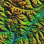
Highly detailed terrain mesh of the Tirich Mir and Pamir areas, N36-39 E71-74. The files in this package are based on Shuttle Radar (SRTM) Version 2 data but with many of the void areas, especially the most significant sections, filled with elevation data generated from topographic maps by Jonathan de Ferranti. While Jonathan's work is unrelated to flight simulation he kindly gave me permission to compile his data for use in FS. The result is a wonderful improvement in detail and accuracy over any existing mesh file, freeware or commercial, based on SRTM or DTED data alone.
Due to the large area of the Himalayas I've compiled the source data as two separate series: the "Himalayan Peaks" series covers prominent mountains and ranges in higher detail and locally overrides any existing LOD9 terrain mesh. In addition, a LOD9 "base mesh" series covering the entire Himalayas will be available for those who do not yet have an add-on terrain mesh of these beautiful mountains.
| Filename: | Himalayan_Peaks_LOD10_Mesh_Volume_8__Tirich_Mir_an.zip |
| License: | Freeware, limited distribution |
| Added: | 29th May 2010, 08:52:47 |
| Downloads: | 9,103 |
| Author: | Holger Sandmann, Jonathan de Ferranti |
| Size: | 47.94 MB |
| Category: Flight Simulator 2004 - Scenery | |
| Canada - British Columbia - Bowron Lake Prov.Park Scenery Update v1.1 |
|
File Description:
Updates V1.0 to v1.1 by adding waterfalls and river rapids in the Cariboo and Isaac Rivers and adds a landclass fix. Designed to compliment UT Canada/Alaska and FSGenesis Cordillera or other 38.2 meter mesh (LOD10) such as Raimondo Taburet freeware mesh for BC. Patches for UT Canada have yet to repair this areas rivers. Located in central BC, Bowron Lake is a world famous canoeing circuit. This scenery fixes two major sections of the Cariboo River that are missing from UT Canada. Includes scenery files, effects, park documents and screenshots.
| Filename: | Canada__British_Columbia__Bowron_Lake_ProvPark_Sce.zip |
| License: | Freeware, limited distribution |
| Added: | 12th October 2005, 09:12:13 |
| Downloads: | 1,866 |
| Author: | Bryan Wallis |
| Size: | 7.91 MB |
| Category: Flight Simulator 2004 - Scenery | |
| Alps Thermals |
|
File Description:
This scenery package covers almost the whole of the German Austrian Swiss and Italian Alps with thermals - now it is possible to fly a sailplane in FS2004 under realistic conditions.
| Filename: | Alps_Thermals.zip |
| License: | Freeware |
| Added: | 1st January 2004, 16:16:00 |
| Downloads: | 5,883 |
| Author: | Herbert and Julian Zemke |
| Size: | 1.34 MB |
| Category: Flight Simulator 2002 - AI Flight Plans | |
| Air Alps Summer 2003 Flight Schedules |
|
File Description:
Accurate Flight Schedules for Air Alps Summer 2003. You will need Traffic Tools by Lee Swordy and a G-max compatible Do 328 in Air Alps colours! More information in the readme file.
| Filename: | Air_Alps_Summer_2003_Flight_Schedules.zip |
| License: | Freeware |
| Added: | 10th June 2003, 19:28:09 |
| Downloads: | 466 |
| Author: | Alex Gerzabek |
| Size: | 6.54 KB |
© 2001-2026 AVSIM Online
All Rights Reserved
Privacy Policy |