
Where Flight Simulation Enthusiasts Gather from Around the World!
AVSIM Library - Search Results

| Category: Flight Simulator X - Scenery | |
| CYQQ (2010) Version 2 for FS9, FSX and Prepar3D |

|
Images related to this file:
File Description:
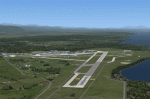
CYQQ (2010) portrays Canadian Forces Base Comox (Vancouver Island, British Columbia, Canada) (CYQQ), the Comox Valley Air Terminal and surrounding area. It is fully compatible with Ultimate Terrain Canada/Alaska for FS2004, Ultimate Terrain X - Canada for FSX and ORBX's FTX NA Blue. CYQQ (2010) includes over 100 "hand-crafted" buildings and other structures and 10 different vintage aircraft on static display, as well as aircraft and traffic files for a realistic AI scenario that causes a variety of military aircraft that come and go. (Use BC Regional AI - also available from this file library - for scheduled traffic.) Civilian AI is now routed so as not to transit military aprons.
Aside from the new approach lighting, generally, this new version is visually identical to its predecessor - even though quite different internally. As well, to the extent possible, it is compatible with Prepar3Dv2.
| Filename: | CYQQ_2010_Version_2_for_FS9_FSX_and_Prepar3D.zip |
| License: | Freeware, limited distribution |
| Added: | 20th June 2014, 11:39:47 |
| Downloads: | 11,034 |
| Author: | Don Grovestine |
| Size: | 33.19 MB |
| Category: Flight Simulator 2004 - Scenery | |
| Vancouver Island and Inner Passage float bases in BC, Canada |
|
File Description:
This is a series of float bases to the east of the northern part of Vancouver Island. They are all zipped together because: first, they are all in the same geographical area and if you like one you may like them all; second it means I only write one set of notes; and third I only upload once. I was looking to fill in the gap between what Holger Sandmann and his cohorts have done with Alaska, and Vancouver and Vancouver Island to the south, and there are these 16 float bases in a stretch of 180 miles between the northern part of Vancouver Island and the mainland coast. And if you leave out the relatively isolated Rivers Inlet to the north then they are all within a 140 mile stretch. Some are on the east coast of Vancouver Island, but most are on islands between the mainland and the island.
| Filename: | Vancouver_Island_and_Inner_Passage_float_bases_in_.zip |
| License: | Freeware |
| Added: | 3rd August 2008, 06:03:09 |
| Downloads: | 1,870 |
| Author: | Roger Wensley & Jim Turner |
| Size: | 6.85 MB |
| Category: Flight Simulator 2004 - Scenery | |
| Point Ellis cannery V1, for Holger Sandmann's Tongass Fjord scenery |
|
Images related to this file:
File Description:
This is a revised version of Point Ellis cannery, originally posted in 2007. It is unsurprisingly just east of Point Ellis, on the east side of the southern end of Chatham Strait in southern Alaska. It is marked on the chart of the area, and if you are chartless then there is a piece of the chart here. This scenery is designed specifically for use in the Tongass Fjord scenery, and probably doesn't work with just Ultimate Terrain. The cannery has an identifying code so it will show up on a gps as "PECA". There is no interaction with atc as there are no designated water runways, so the "PECA" on the gps just acts as a waypoint. There will be further posts for use with Tongass Fjords, Misty Fjords, and Glacier Bay, and I still find these scenery areas by Holger and his crew the most satisfying in FS9.
| Filename: | Point_Ellis_cannery_V1_for_Holger_Sandmanns_Tongas.zip |
| License: | Freeware, limited distribution |
| Added: | 6th November 2014, 21:55:48 |
| Downloads: | 237 |
| Author: | Roger Wensley |
| Size: | 3.86 MB |
| Category: Flight Simulator X - Aircraft Repaints, Textures and Modifications | |
| Fokker 100 Repaint Mega Pack Part Two |
|
Images related to this file:
File Description:
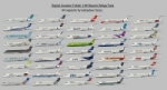
This is a repaint pack for the Digital Aviation Fokker 100. I have included 44 repaints of airlines from all over the world. There are some fictional and some real repaints included, so you can fly with this aircraft everywhere! The following airlines are included: China Eastern, Skyways, Merpati Nusantara, Carpatair, Belleair, Air France by Regional, Dutch Antilles Express, Korean Air, Montenegro Airlines, Skywest, Spanair, South African Airways, ANA, Tunisair, Nigerian Eagle, Aerolineas Argentinas, Royal Jordanian, Fly Be, United, S7, TAME, PIA Pakistan International, Precision Air, Thai International Airlines, Alaska Air, Olympic Air, Delta, Air Baltic, TAM, Kenya Airways, Iberia, Lan, British Airways, Air Canada, Alitalia, Philippine Airlines, SAS, Lufthansa, Air Caraibes, Continental, UTair, Air China, Dragonair and Turkish Airlines!
IMPORTANT: This is part two of the repaint pack, you will need part one, in order to have all repaints: DA_Fokker100_repaintmegapack_part_ONE.zip
By Sebastian Szucs
| Filename: | Fokker_100_Repaint_Mega_Pack_Part_Two.zip |
| License: | Freeware, limited distribution |
| Added: | 11th May 2010, 23:12:36 |
| Downloads: | 6,580 |
| Author: | Sebastian Szucs |
| Size: | 89.97 MB |
| Category: Flight Simulator X - Flight Plans | |
| Chas mod of Stearmandriver RNP RNAV Approach into PAJN Rwy 26 for 737NGX |
|
Images related to this file:
File Description:
Modded StearmanDriver(SD) RNP RNAV Rwy 26 into PAJN, Juneau, Alaska. SD gave us a cool little route that while not LATLONG nor Fixname accurate, it couldn't be without legal and occupational liabilities...and it worked, but if you look at his FixNames and the LATLONG from the PAJN.txt file for the 737 NGX...it did work pretty nicely...at least as nicely as the charted RNAV course into Rwy 8. So I created my own procedure LATLONG rightly or wrongly in a multi-step procedure as follows:
1. I took the raw info provided by SD and flew to each of his waypoints,(if you look, almost all of his FIXs were rounded off...to avoid company or legal problems) noting safe altitude, starting out at 7000ft, creating user waypoints in my GTN750, looking around for first, vertical, then horizontal safety...keeping in mind that Ultimately...I would not be using this data for my Duke, but for the Procedure page of my PMDG 737 NGX..which you already saw me fly with SD's fixes.
2. I took my Turbine Duke up and noted the REAL LATLONG as reported by slewing and world map...transposed those numbers into the format that PMDG's procedures needed DDD.mm fractional minutes. I converted using http://www.directionsmag.com/site/latlong-converter/
3.I created my own mid-point user waypoints from the west CHRTRN,and the NNE CHRTS so we could have approaches from those directions.
4. I put my Duke into autopilot, knowing the lateral info...my flightplan was correct, but I would have to handle the Vnav manually. Turns out its rather manageable with the following info: CHRTRN 5000FT - MARMN 3500FT - TRDWL 2500FT - SALMN 1500 - LEMNN 500 - PAJN5 50
My MOD OF SDs RNP RNAV PAJNRwy 26, will be up on Avsim as ChasModRNP RNAV PAJN Rwy 26.zip
Contact:[email protected] - Support: http://forum.avsim.net/topic/466094-any-interest-in-updated-se-alaska-rnav-rnp-approach-procedures-including-juneau/
| Filename: | Chas_mod_of_Stearmandriver_RNP_RNAV_Approach_into_.zip |
| License: | Freeware |
| Added: | 8th May 2015, 11:35:16 |
| Downloads: | 339 |
| Author: | Chas Reed |
| Size: | 144.78 KB |
| Category: Flight Simulator X - Missions | |
| Rescue Bill Bunyan |
|
File Description:
Jake, the Bold Airport (Alaska) manager just got a CB call from Bill Bunyan, master sasquatch tracker. Bill has hurt his right ankle quite seriously, and needs to by picked up by someone with a ski-equipped airplane. Your Maule is just such a plane. Bill isn't quite sure exactly where he is, but does know he's not too far from Bold Ridge. So you have one waypoint to work with. After that it's up to you. To help, Bill is burning a campfire. He says it's fairly flat at his location, but to watch out for bushes, small trees, and grizzly bears. As an experienced mountain flyer, you know that such rescues benefit from getting as much altitude as the weather allows, before getting into the mountains. Bill thinks he's in an area that's 4000 or more feet ASL, but it's snowing heavily. Don't forget to lower your skis before landing at Bill's location, and to raise them before landing back at the Airport.
| Filename: | Rescue_Bill_Bunyan.zip |
| License: | Freeware |
| Added: | 7th December 2014, 22:48:28 |
| Downloads: | 641 |
| Author: | Dan Cowan |
| Size: | 41.11 MB |
| Category: Flight Simulator 2004 - Scenery | |
| Hawk Logging, for Holger Sandmann's scenery |
|
Images related to this file:
File Description:
This is a logging camp, on Admiral Island at the northern end of Chatham Strait in southern Alaska, around 30 miles south of Juneau. It is marked on the chart of the area; if you are chartless then there is a section of the chart included here. This scenery is designed specifically for use in the Tongass Fjord scenery (or Glacier, or Misty? I don't remember now which area it is in!) and probably does not work with just Ultimate Terrain; I haven't tried it. The camp has an identifying code so it will show up on a gps as PELC but there is no interaction with atc as there are no designated water runways; PELC on the GPS just acts as a waypoint. There will be further posts for use with Tongass Fjords, Misty Fjords, and Glacier Bay, and I still find these scenery areas by Holger and his crew the most satisfying in FS9.
| Filename: | Hawk_Logging_for_Holger_Sandmanns_scenery.zip |
| License: | Freeware, limited distribution |
| Added: | 8th November 2014, 22:42:24 |
| Downloads: | 317 |
| Author: | Roger Wensley |
| Size: | 12.37 MB |
| Category: Flight Simulator 2004 - Scenery | |
| Misty Moorings DynaScene Scenario - 08/18/2005 |
|
File Description:
DynaScene scenario based scenery file for Misty Moorings members and other interested parties. (Misty Fjords Scenery from www.fsaddon.com required). Provides background text, photos, and scenery for a temporary scenario. Story as follows: NEWS FLASH! 08/18/2005 - BUSH PILOT GROUNDED PENDING INVESTIGATION - KETCHIKAN (APX) - The alaska wilderness is no stranger to strange tales. At least that's how it appears in the case of a local bush pilot, Randy Morgan, who had quite a large one to tell.
At 6 PM on the evening of the 16th, Randy and one passenger took off in a Cessna 182RG from Maloney's Tavern on his way back to Ketchikan. "The weather was good and I had no idea what was about to happen" said Randy Morgan. "We had planned our flight to pass over Raptor's Roost and Punchbowl Lake before heading into Ketchikan when I saw it." (full text in download) - Makes use of Rwy12 libraries by Seev Kahn and Glen Gordon (included in download).
| Filename: | Misty_Moorings_DynaScene_Scenario__08182005.zip |
| License: | Freeware |
| Added: | 22nd August 2005, 01:04:19 |
| Downloads: | 968 |
| Author: | Glen Gordon (Professor Khaos) |
| Size: | 4.76 MB |
| Category: Flight Simulator X - Scenery | |
| Redtail Ridge Island Resort (AK94) |
|
File Description:
Redtail Ridge is a fictitious place in Alaska, but it's name is somewhat misleading as there is no ridges on the island. The airport boasts a 2300x45FT dirt runway, although it displays as a snow runway. There is also a 10000FT water runway, marked at each end with a red buoy. The airport is mainly intended as a place for the weary bush pilot to go and relax. There is a line of lakeside cabins to stay in, and there's even three little docks for floatplanes to tie up at. Also available are a selection of boats to rent, both sailboats and motorboats. For transportation around, there is a even a rental car angency. If the cabins are filled, stay in the hotel or sleep outdoors in the campsites. Go shopping at the mall or grab a bite to eat at the fast food joints. Anything you need to relax, you can find it here!
| Filename: | Redtail_Ridge_Island_Resort_AK94.zip |
| License: | Freeware |
| Added: | 2nd January 2008, 02:49:44 |
| Downloads: | 716 |
| Author: | Joe Brown |
| Size: | 5.2 KB |
| Category: Flight Simulator 2004 - AFCAD Files | |
| King County International (Boeing Field - KBFI) |
|
File Description:
King County International Airport is located 5 miles south of downtown Seattle and has the distinction of being the Boeing Company's final test site for the 737, 757, and 777 aircraft. Flight plans are included for 14 aircraft undergoing final tests prior to delivery to their respective airlines. Each aircraft will fly Monday through Friday for flights of approximately 3-1/2 hours. Since FS9 doesn't support flights that depart and arrive at the same airport, I've added a waypoint where the a/c can stop over for 15 minutes. The stopover is at Annette Island, Alaska, and I've included an AFCAD for an upgraded Annette Island "International" airport that, of course, doesn't really exist. If you wish to visit Annette Island International, there are runways equipped with the latest in ILS instrumentation. See the additional documentation I've included in the READ MEs. Commercial flights from Boeing Field are also provided by Helijet and San Juan Airlines.
| Filename: | King_County_International_Boeing_Field__KBFI.zip |
| License: | Freeware |
| Added: | 15th March 2004, 06:30:36 |
| Downloads: | 4,179 |
| Author: | Steve Lewis |
| Size: | 637.02 KB |
© 2001-2026 AVSIM Online
All Rights Reserved
Privacy Policy |