
Where Flight Simulation Enthusiasts Gather from Around the World!
AVSIM Library - Search Results

| Category: Flight Simulator 2004 - Scenery | |
| Lake Simcoe Regional for Ultimate Terrain |

|
File Description:
Located sixty miles north of Toronto equidistant between the Cities of Barrie and Orillia, Lake Simcoe Regional CNB9 is situated adjacent to Lake Simcoe in one of the fastest growing areas in Canada. Welcome to the gateway to “Cottage Country”
www.flightontario.com
| Filename: | Lake_Simcoe_Regional_for_Ultimate_Terrain.zip |
| License: | Freeware |
| Added: | 8th January 2006, 04:19:49 |
| Downloads: | 3,454 |
| Author: | Jim Kanold - Flight Ontario |
| Size: | 12.35 MB |
| Category: Flight Simulator 2004 - Scenery | |
| Update SDJD-Jundiaí Terrain bug fix |
|
File Description:
Update for my other file.
| Filename: | Update_SDJDJundia_Terrain_bug_fix.zip |
| License: | Freeware |
| Added: | 21st August 2007, 21:51:21 |
| Downloads: | 2,129 |
| Author: | João Mateus Lobo Guerra |
| Size: | 3.38 KB |
| Category: Flight Simulator 2004 - Scenery | |
| Replacement Landclass for Atlanta / Ultimate Terrain |
|
File Description:
Landclass adjustment for the Atlanta metro area, primarily for use with Ultimate Terrain. This will change the majority of the "grid" urban and suburban tiles to "non-grid" versions, resulting in a much more realistic look around Atlanta, as most roads twist and turn in a seemingly random fashion. The core downtown / midtown areas are transparent to allow the original UT grid landclass to show through.
| Filename: | Replacement_Landclass_for_Atlanta__Ultimate_Terrai.zip |
| License: | Freeware |
| Added: | 7th August 2006, 03:02:04 |
| Downloads: | 1,181 |
| Author: | Guy Elden Jr. |
| Size: | 1.38 MB |
| Category: Flight Simulator 2004 - Scenery | |
| Devils Tower Terrain Mesh (ver 2) |
|
File Description:
This terrain mesh covers most of Crook County, Wyoming which contains Devils Tower National Monument. This terrain mesh was obtained from NED 1 arc second data and resampled to LOD10 resolution (38.2m). The area near the Devils Tower was obtained from NED 1/3 arc second data and resampled to LOD11 resolution (19.1m). The exact coverage is everything between W105* 7' 30" to W104* 0' 0" by N45* 0' 0" to N44* 15' 0". Devils Tower can be found by starting at Ipy Ranch (WY14) and traveling on a track of 194 degrees for 3 nautical miles. This version corrects a major positional error that was present in the first release and includes higher resolution data near the Devils Tower.
| Filename: | Devils_Tower_Terrain_Mesh_ver_2.zip |
| License: | Freeware |
| Added: | 26th November 2003, 00:25:13 |
| Downloads: | 3,556 |
| Author: | Joshua Robertson, 3D Softworks Design Studios |
| Size: | 4.54 MB |
| Category: Flight Simulator 2004 - Scenery | |
| Canary Islands 76m SRTM Terrain Mesh |
|
File Description:
USGS SRTM 3 arc-second, resampled to LOD9 (76 meters).
This is a terrain mesh scenery of the Canary Islands west of Morocco, Africa.
It includes the following islands: Hierro, La Palma, La Gomera, Tenerife, Gran Canaria, Fuerteventura, Lanzarote
| Filename: | Canary_Islands_76m_SRTM_Terrain_Mesh.zip |
| License: | Freeware, limited distribution |
| Added: | 4th April 2004, 06:56:49 |
| Downloads: | 18,600 |
| Author: | Andreas Trawny |
| Size: | 2.99 MB |
| Category: Flight Simulator X - Scenery | |
| Detailed Terrain Features for Southern Africa |
|
Images related to this file:
File Description:
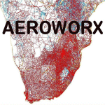
Scenery consist of coastlines, rivers, dams, streams, roads, traffic, railroads, power lines and extrusion bridges for Southern Africa countries South of the Equator. The scenery was design by utilizing Satellite image backgrounds.
This scenery is important and will be needed with release of future scenery by Aeroworx.
| Filename: | Detailed_Terrain_Features_for_Southern_Africa.zip |
| License: | Freeware |
| Added: | 25th August 2012, 18:43:04 |
| Downloads: | 8,902 |
| Author: | Hannes Steyn, Aeroworx |
| Size: | 27.79 MB |
| Category: Flight Simulator 2004 - Scenery | |
| Cyprus & Crete incl. Surroundings SRTM Terrain Mesh |
|
File Description:
Cyprus & Crete incl. Surroundings SRTM Terrain Mesh.
3arcsec source data resampled to LOD9 76m
| Filename: | Cyprus__Crete_incl_Surroundings_SRTM_Terrain_Mesh.zip |
| License: | Freeware, limited distribution |
| Added: | 12th June 2004, 04:54:31 |
| Downloads: | 13,290 |
| Author: | Tom Finley |
| Size: | 4.16 MB |
| Category: Flight Simulator 2002 - Scenery Design | |
| CellGrid2 |
|
File Description:
CellGrid2 replaces the original CellGrid. CellGrid2 is a collection of BGLC Macros that allow the creation of a visual grid within FS2002 and CFS2, that covers an entire LOD8 TDF Cell. Very useful for designers working with BGLC and the New FS2002 Terrain SDK. Also included are TDFCalc.exe ( a useful locational calculator for Terrain Data File design ). LandCalc ( a useful tool for the creation of CUSTOM textures, for use in landclass BGLs ).
| Filename: | CellGrid2.zip |
| License: | Freeware |
| Added: | 15th November 2002, 18:49:45 |
| Downloads: | 1,944 |
| Author: | Richard Ludowise |
| Size: | 967.86 KB |
| Category: Flight Simulator 2004 - Scenery | |
| Bellefonte Airport N96 |
|
Images related to this file:
File Description:
FS2004 Scenery - Bellefonte Airport (N96) serves Bellefonte and Centre County and is owned by John & Marina Elnitski. The paved runway extends for 3600 feet. The facility is at an elevation of 1080 feet at a distance of about 3 miles from Bellefonte. Test in Ultimate Terrain and Default FS. By John B. Loney, Jr.
| Filename: | Bellefonte_Airport_N96.zip |
| License: | Freeware, limited distribution |
| Added: | 27th February 2011, 04:40:12 |
| Downloads: | 274 |
| Author: | John B. Loney, Jr. |
| Size: | 1.94 MB |
| Category: Flight Simulator X - Scenery | |
| Adak Airport Alaska |
|
Images related to this file:
File Description:
Adak airport Alaska for FSX made from a custom designed terminal building and AFCAD and all taxiways correctly marked.FSX Acceleration will give the best results.(Also SP2 compatable).Acceleration users will have more eye candy !This was made for Ultimate Terrain Alaska,do work in default FSX but you will not see all the buildings.
| Filename: | Adak_Airport_Alaska.zip |
| License: | Freeware |
| Added: | 26th December 2011, 12:58:31 |
| Downloads: | 2,779 |
| Author: | Frits Beyer, Jacques Botha |
| Size: | 494.38 KB |
© 2001-2026 AVSIM Online
All Rights Reserved
Privacy Policy |