
Where Flight Simulation Enthusiasts Gather from Around the World!
AVSIM Library - Search Results

| Category: Flight Simulator X - Scenery | |
| South America Mesh Scenery, MeshX_C5 |

|
File Description:
Mesh terrain scenery for the whole continental South America, based on SRTM 90m
dem geotiff files resampled to 76 meter of horizontal resolution (LOD 9). The new files have
improved the vertical resolution from 16m to 10m, resulting in more details
and accuracy over previous versions. There are 50 files, compatible with FS 9
and FS X, identified in a map by column letter and line number, covering the
contiguous countries and states. Boundaries: N = 11º 15' S; S = 16º 52.5' S;
E = 56º 15' W; W = 63º 45' W.
| Filename: | South_America_Mesh_Scenery_MeshX_C5.zip |
| License: | Freeware |
| Added: | 28th October 2006, 23:27:21 |
| Downloads: | 1,456 |
| Author: | Oséas Dourado and José Lôbo |
| Size: | 35.44 MB |
| Category: Flight Simulator X - Scenery | |
| South America Mesh Scenery, MeshX_C4 |
|
File Description:
Mesh terrain scenery for the whole continental South America, based on SRTM 90m
dem geotiff files resampled to 76 meter of horizontal resolution (LOD 9). The new files have
improved the vertical resolution from 16m to 10m, resulting in more details
and accuracy over previous versions. There are 50 files, compatible with FS 9
and FS X, identified in a map by column letter and line number, covering the
contiguous countries and states. Boundaries: N = 5º 37.5' S; S = 11º 15' S;
E = 56º 15' W; W = 63º 45' W.
| Filename: | South_America_Mesh_Scenery_MeshX_C4.zip |
| License: | Freeware |
| Added: | 28th October 2006, 23:27:57 |
| Downloads: | 1,441 |
| Author: | Oséas Dourado and José Lôbo |
| Size: | 39.66 MB |
| Category: Flight Simulator X - Scenery | |
| South America Mesh Scenery, MeshX_Z234 |
|
File Description:
Mesh terrain scenery for the whole continental South America, based on SRTM 90m
dem geotiff files resampled to 76 meter of horizontal resolution (LOD 9). The new files have
improved the vertical resolution from 16m to 10m, resulting in more details
and accuracy over previous versions. There are 50 files, compatible with FS 9
and FS X, identified in a map by column letter and line number, covering the
contiguous countries and states. Boundaries: N = 1º 24.375' N; S = 8º 26.25' S;
E = 78º 45' W; W = 82º 30' W.
| Filename: | South_America_Mesh_Scenery_MeshX_Z234.zip |
| License: | Freeware |
| Added: | 29th October 2006, 10:41:03 |
| Downloads: | 1,657 |
| Author: | Oséas Dourado and José Lôbo |
| Size: | 19.95 MB |
| Category: Flight Simulator X - Scenery | |
| South America Mesh Scenery MeshX_A9 |
|
File Description:
Mesh terrain scenery for the whole continental South America, based on SRTM 90m
dem geotiff files resampled to 76 meter of horizontal resolution (LOD 9). The new files have
improved the vertical resolution from 16m to 10m, resulting in more details
and accuracy over previous versions. There are 50 files, compatible with FS 9
and FS X, identified in a map by column letter and line number, covering the
contiguous countries and states. Boundaries: N = 33º 45' S; S = 39º 22.5' S;
E = 71º 15' W; W = 78º 45' W.
| Filename: | South_America_Mesh_Scenery_MeshX_A9.zip |
| License: | Freeware |
| Added: | 30th October 2006, 00:33:36 |
| Downloads: | 2,132 |
| Author: | Oséas Dourado and José Lôbo |
| Size: | 12.6 MB |
| Category: Flight Simulator X - Scenery | |
| South America Mesh Scenery MeshX_A10 |
|
File Description:
Mesh terrain scenery for the whole continental South America, based on SRTM 90m
dem geotiff files resampled to 76 meter of horizontal resolution (LOD 9). The new files have
improved the vertical resolution from 16m to 10m, resulting in more details
and accuracy over previous versions. There are 50 files, compatible with FS 9
and FS X, identified in a map by column letter and line number, covering the
contiguous countries and states. Boundaries: N = 39º 22.5' S; S = 45º 0' S;
E = 71º 15' W; W = 78º 45' W.
| Filename: | South_America_Mesh_Scenery_MeshX_A10.zip |
| License: | Freeware |
| Added: | 30th October 2006, 00:49:28 |
| Downloads: | 2,803 |
| Author: | Oséas Dourado and José Lôbo |
| Size: | 17.38 MB |
| Category: Flight Simulator X - Scenery | |
| South America Mesh, MeshX_B10 |
|
File Description:
Mesh terrain scenery for the whole continental South America, based on SRTM 90m
dem geotiff files,
resampled to 76 meter of horizontal resolution (LOD 9). The new files have
improved the vertical resolution from 16m to 10m, resulting in more details
and accuracy over previous versions. There are 50 files, compatible with FS 9
and FS X, identified in a map by column letter and line number, covering the
contiguous countries and states. Boundaries: N = 39º 22.5' S; S = 45º 0' S;
E = 63º 45' W; W = 71º 15' W.
| Filename: | South_America_Mesh_MeshX_B10.zip |
| License: | Freeware |
| Added: | 30th October 2006, 01:47:45 |
| Downloads: | 2,207 |
| Author: | Oséas Dourado, José Lôbo |
| Size: | 32.13 MB |
| Category: Flight Simulator 2004 - Scenery | |
| Ponte de Sor - Portugal |
|
Images related to this file:
File Description:
Ponte de Sor Municipal Airfield. Several buildings still under construction as well a new rwy. LPMS is a fake I create once, altough this is an certified airfield, it's ICAO has not yet been published (so far I know).
This scenery is fully compatible with Portugal Terrain from PTSIM (http://www.ptsim.com) and is based on digital pictures, accurate real measures by Aerodromos de Portugal. (http://www.pelicano.com.pt/zmapa.html) and Google Earth. This is 1st release, ugrade expected to be available soon.
Freeware. For Microsoft FS2004.NOT tested for FSX
| Filename: | Ponte_de_Sor__Portugal.zip |
| License: | Freeware |
| Added: | 15th April 2011, 01:05:44 |
| Downloads: | 394 |
| Author: | Joao Antonio Graca Ferreira |
| Size: | 2.58 MB |
| Category: Flight Simulator 2004 - Scenery | |
| Project Mexico Real LOD10 File 10 of 11 |
|
Images related to this file:
File Description:
Re-upload. File 10th of 11 of a Terrain Mesh that covers the entirety of Mexican Territory and related bordering U.S., Guatemala and Belice areas, part of the "Proyecto Mexico Real" project, compiled at LOD10 (1.24 arcseconds in latitude and 1.65 arcseconds in longitude) resolution from INEGI data. Intended to enhance the virtual flying experience complementing the LOD8 and LOD9 versions compiled from the same data. Compatible backwards with Flight Simulator 2000, Flight Simulator 2002 and Combat Flight Simulator 2. Refer to the file contents about the cover area to this compressed file.
| Filename: | Project_Mexico_Real_LOD10_File_10_of_11.zip |
| License: | Check within download |
| Added: | 5th September 2010, 20:55:05 |
| Downloads: | 3,060 |
| Author: | Juan Jose Galvan Bautista |
| Size: | 70.54 MB |
| Category: Flight Simulator X - Scenery | |
| British Columbia Floatbases |
|
Images related to this file:
File Description:
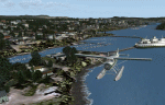
This is a collection of floatbases around the coast of British Columbia made with default scenery objects, and derived from Google Earth and the Canada Waterdrome Supplement. This scenery is designed to complement the work of others and therefore doesn't include waterdromes made by others such as Sidney Schwartz's CYYJ, Ganges Harbour and BCPNW Float Bases which covers an area around the Gulf Islands. You must have Ultimate Terrain Canada for these sceneries to work and in areas away from the immediate coast (Fraser River), a SRTM mesh for the correct elevations.
| Filename: | British_Columbia_Floatbases.zip |
| License: | Freeware |
| Added: | 16th May 2012, 14:02:09 |
| Downloads: | 1,537 |
| Author: | Chris Peschke |
| Size: | 183.32 KB |
| Category: Flight Simulator 2004 - Scenery | |
| Project Mexico Real LOD10 File 3 of 11 |
|
Images related to this file:
File Description:
Re-upload. File 3rd of 11 of a Terrain Mesh that covers the entirety of Mexican Territory and related bordering U.S., Guatemala and Belice areas, part of the "Proyecto Mexico Real" project, compiled at LOD10 (1.24 arcseconds in latitude and 1.65 arcseconds in longitude) resolution from INEGI data. Intended to enhance the virtual flying experience complementing the LOD8 and LOD9 versions compiled from the same data. Compatible backwards with Flight Simulator 2000, Flight Simulator 2002 and Combat Flight Simulator 2. Refer to the file contents about the cover area to this compressed file.
| Filename: | Project_Mexico_Real_LOD10_File_3_of_11.zip |
| License: | Check within download |
| Added: | 8th June 2010, 03:17:03 |
| Downloads: | 3,253 |
| Author: | Juan Jose Galvan Bautista |
| Size: | 73.67 MB |
© 2001-2026 AVSIM Online
All Rights Reserved
Privacy Policy |