
Where Flight Simulation Enthusiasts Gather from Around the World!
AVSIM Library - Search Results

| Category: Flight Simulator X - AFCAD Files | |
| HKJK Airport Layout for FSX |

|
File Description:
Airport layout file (AFCAD) for the default HKJK Jomo Kenyatta International Airport in FSX. Tested with World of AI only. Gate numbers are 1-11 for medium and large aircraft, 12-20 for props. This version includes only limited gate assignments. Northern parking area includes stands for military aircraft. Southern cargo apron has four stands with real-life operators assigned. This is the latest version with enlarged apron.
| Filename: | HKJK_Airport_Layout_for_FSX.zip |
| License: | Freeware, limited distribution |
| Added: | 13th January 2008, 00:22:01 |
| Downloads: | 1,346 |
| Author: | Marten Weber |
| Size: | 111.06 KB |
| Category: Flight Simulator X - Scenery | |
| Waterford City and Airport - Ireland |
|
File Description:
The scenery consists of Waterford City and Airport in Ireland. The airport consists of two files, one created by the IFSD team who sadly are no longer operational and the second was created with Instant Scenery. The files are best viewed with UTX Europe as all buildings have been aligned with UTX roads. Only FSX autogen objects have been used, so the scenery has little impact on FPS. Enjoy.
| Filename: | Waterford_City_and_Airport__Ireland.zip |
| License: | Freeware |
| Added: | 2nd December 2009, 14:27:34 |
| Downloads: | 1,871 |
| Author: | George Keogh and IFSD Team |
| Size: | 9.93 MB |
| Category: Flight Simulator X - Scenery | |
| Avalon Catalina - California (CA), USA |
|
Images related to this file:
File Description:
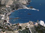
The city of Avalon on Catalina Island with many custom built objects including the Turret House, Wrigley Memorial, Pier, working Bell Tower (sounds), and several businesses and hotels. This scenery was designed around the freeware Catalina Island by Aerosoft and is required for this scenery to display correctly. FS2002 version of this scenery has over 5500 downloads. Tested on FSX Gold Edition (FSX Deluxe and Acceleration Expansion Pack), FSGenesis 9.6 terrain mesh, and Win7 operating system. Requires RWEOBJv5.zip & RWEOBJc5.zip (or later) Object Libraries. By Ron Ezra
| Filename: | Avalon_Catalina__California_CA_USA.zip |
| License: | Freeware |
| Added: | 14th January 2016, 19:29:50 |
| Downloads: | 903 |
| Author: | Ron Ezra |
| Size: | 1.53 MB |
| Category: Flight Simulator 2004 - Scenery | |
| Project México Real LOD10 File 4 of 11 |
|
File Description:
File 4th of 11 of a Terrain Mesh that covers the entire Mexican Territory and related areas bordering the U.S., Guatemala and Belice areas. Part of the "Proyecto México Real" project, compiled at LOD10 (1.24 arcseconds in latitude and 1.65 arcseconds in longitude) resolution from INEGI data. Intended to enhance the virtual flying experience complementing the LOD8 and LOD9 versions compiled from the same data. Compatible backwards with Flight Simulator 2000, Flight Simulator 2002 and Combat Flight Simulator 2. Refer to the file contents about the cover area to this compressed file.
| Filename: | Project_Mxico_Real_LOD10_File_4_of_11.zip |
| License: | Check within download |
| Added: | 6th June 2006, 00:58:59 |
| Downloads: | 3,065 |
| Author: | Juan José Galván Bautista |
| Size: | 74.49 MB |
| Category: Flight Simulator 2004 - Scenery | |
| Project México Real LOD10 File 6 of 11 |
|
File Description:
File 6th of 11 of a Terrain Mesh that covers the entire Mexican Territory and related areas bordering the U.S., Guatemala and Belice areas. Part of the "Proyecto México Real" project, compiled at LOD10 (1.24 arcseconds in latitude and 1.65 arcseconds in longitude) resolution from INEGI data. Intended to enhance the virtual flying experience complementing the LOD8 and LOD9 versions compiled from the same data. Compatible backwards with Flight Simulator 2000, Flight Simulator 2002 and Combat Flight Simulator 2. Refer to the file contents about the cover area to this compressed file.
| Filename: | Project_Mxico_Real_LOD10_File_6_of_11.zip |
| License: | Check within download |
| Added: | 6th June 2006, 01:07:16 |
| Downloads: | 3,022 |
| Author: | Juan José Galván Bautista |
| Size: | 71.63 MB |
| Category: Flight Simulator 2004 - Scenery | |
| Project México Real LOD10 File 11 of 11 |
|
File Description:
File 11th of 11 of a Terrain Mesh that covers the entirety of Mexican Territory and related bordering U.S., Guatemala and Belice areas, part of the "Proyecto México Real" project, compiled at LOD10 (1.24 arcseconds in latitude and 1.65 arcseconds in longitude) resolution from INEGI data. Intended to enhance the virtual flying experience complementing the LOD8 and LOD9 versions compiled from the same data. Compatible backwards with Flight Simulator 2000, Flight Simulator 2002 and Combat Flight Simulator 2. Refer to the file contents about the cover area to this compressed file.
| Filename: | Project_Mxico_Real_LOD10_File_11_of_11.zip |
| License: | Check within download |
| Added: | 6th June 2006, 01:52:33 |
| Downloads: | 3,095 |
| Author: | Juan José Galván Bautista |
| Size: | 69.98 MB |
| Category: Flight Simulator 2004 - Scenery | |
| JRM Bahamas EZ Scenery Part #3 |
|
File Description:
FS2004 JRM Bahamas EZ Scenery Part #3
FS9+ EZ scenery Eleutheria Island JRM_Bhm3.zip (see JRM_bhm1.zip & JRM_bhm2.zip) This scenery utilizes FS Global Terrain Mesh and GroundEnv-1. All objects are available by download linked inside. Requires LAGO registered with updates. Completes Eleutheria & Cat Islands.Payware expected detail in which you can even motorcar on sightseeing trips stopping and watching all the eye candy. This scenery completes Eleutheria & Cat Island Bahamas FS9 & FSX only. My best yet and more to come! jimmy R martin [email protected] John 3:16
| Filename: | JRM_Bahamas_EZ_Scenery_Part_3.zip |
| License: | Freeware |
| Added: | 25th March 2006, 03:42:23 |
| Downloads: | 943 |
| Author: | jimmy R martin |
| Size: | 468.29 KB |
| Category: Flight Simulator X - Scenery | |
| South America Mesh Scenery, MeshX_F3 |
|
File Description:
Mesh terrain scenery for the whole continental South America, based on SRTM 90m
dem geotiff files resampled to 76 meter of horizontal resolution (LOD 9).
The new files have improved the vertical resolution from 16m to 10m, resulting
in more details and accuracy over previous versions. There are 50 files, compatible
with FS9 and FS X, identified in a map by column letter and line number, covering the
contiguous countries and states. Boundaries: N = 0º 0' S; S = 5º 37.5' S;
E = 33º 45' W; W = 41º 15' W;
| Filename: | South_America_Mesh_Scenery_MeshX_F3.zip |
| License: | Freeware |
| Added: | 28th October 2006, 10:09:48 |
| Downloads: | 1,414 |
| Author: | Oséas Dourado and José Lôbo |
| Size: | 10.96 MB |
| Category: Flight Simulator X - Scenery | |
| South America Mesh Scenery, MeshX_D1 |
|
File Description:
Mesh terrain scenery for the whole continental South America, based on SRTM 90m
dem geotiff files,resampled to 76 meter of horizontal resolution (LOD 9). The new files have
improved the vertical resolution from 16m to 10m, resulting in more details
and accuracy over previous versions. There are 50 files, compatible with FS 9
and FS X, identified in a map by column letter and line number, covering the
contiguous countries and states. Boundaries: N = 11º 15' N; S = 5º 37.5' N;
E = 48º 45' W; W = 56º 15' W.
| Filename: | South_America_Mesh_Scenery_MeshX_D1.zip |
| License: | Freeware |
| Added: | 28th October 2006, 19:48:20 |
| Downloads: | 1,406 |
| Author: | Oséas Dourado and José Lôbo |
| Size: | 2.89 MB |
| Category: Flight Simulator X - Scenery | |
| South America Mesh Scenery, MeshX_D3 |
|
File Description:
Mesh terrain scenery for the whole continental South America, based on SRTM 90m
dem geotiff files resampled to 76 meter of horizontal resolution (LOD 9). The new files have
improved the vertical resolution from 16m to 10m, resulting in more details
and accuracy over previous versions. There are 50 files, compatible with FS 9
and FS X, identified in a map by column letter and line number, covering the
contiguous countries and states. Boundaries: N = 0º 0' S; S = 5º 37.5' S;
E = 48º 45' W; W = 56º 15' W.
| Filename: | South_America_Mesh_Scenery_MeshX_D3.zip |
| License: | Freeware |
| Added: | 28th October 2006, 19:50:25 |
| Downloads: | 1,476 |
| Author: | Oséas Dourado and José Lôbo |
| Size: | 38.77 MB |
© 2001-2026 AVSIM Online
All Rights Reserved
Privacy Policy |