
Where Flight Simulation Enthusiasts Gather from Around the World!
AVSIM Library - Search Results

| Category: Flight Simulator 2004 - Scenery | |
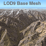
| Himalayas LOD9 Base Mesh, Volume 5 - Hindu Kush and Pamir |

|
Images related to this file:
File Description:

Detailed terrain mesh of the Hindu Kush and Pamir Ranges, N32-40 E70-76. The files in this package are based on Shuttle Radar (SRTM) Version 2 data but with many of the void areas, especially the most significant sections, filled with elevation data generated from topographic maps by Jonathan de Ferranti. While Jonathan's work is unrelated to flight simulation he kindly gave me permission to compile his data for use in FS. The result is a wonderful improvement in detail and accuracy over any existing mesh file, freeware or commercial, based on SRTM or DTED data alone.
Due to the large area of the Himalayas I've compiled the source data as two separate series: the "Himalayan Peaks" series covers prominent mountains and ranges in higher detail and locally overrides any existing LOD9 terrain mesh. In addition, the LOD9 "base mesh" series, with LOD8 and LOD7 "buffer" mesh files, covering the entire Himalayas, is meant for those who do not yet have an add-on terrain mesh of these beautiful mountains.
| Filename: | Himalayas_LOD9_Base_Mesh_Volume_5__Hindu_Kush_and_.zip |
| License: | Freeware, limited distribution |
| Added: | 29th May 2010, 08:57:29 |
| Downloads: | 7,604 |
| Author: | Holger Sandmann, Jonathan de Ferranti |
| Size: | 85.72 MB |
| Category: Flight Simulator 2004 - Scenery | |
| Himalayas LOD9 Base Mesh, Volume 2 - Southcentral Ranges |
|
Images related to this file:
File Description:

Detailed terrain mesh of the Southcentral Himalayan Ranges, N26-32 E82-90. The files in this package are based on Shuttle Radar (SRTM) Version 2 data but with many of the void areas, especially the most significant sections, filled with elevation data generated from topographic maps by Jonathan de Ferranti. While Jonathan's work is unrelated to flight simulation he kindly gave me permission to compile his data for use in FS. The result is a wonderful improvement in detail and accuracy over any existing mesh file, freeware or commercial, based on SRTM or DTED data alone.
Due to the large area of the Himalayas I've compiled the source data as two separate series: the "Himalayan Peaks" series covers prominent mountains and ranges in higher detail and locally overrides any existing LOD9 terrain mesh. In addition, a LOD9 "base mesh" series, with LOD8 and LOD7 "buffer" mesh files, covering the entire Himalayas, is meant for those who do not yet have an add-on terrain mesh of these beautiful mountains.
| Filename: | Himalayas_LOD9_Base_Mesh_Volume_2__Southcentral_Ra.zip |
| License: | Freeware, limited distribution |
| Added: | 29th May 2010, 09:05:56 |
| Downloads: | 9,450 |
| Author: | Holger Sandmann, Jonathan de Ferranti |
| Size: | 90.25 MB |
| Category: Flight Simulator 2004 - Scenery | |
| Himalayas LOD9 Base Mesh, Volume 1 - Southeastern Ranges |
|
Images related to this file:
File Description:
Detailed terrain mesh of the Southeastern Himalayan Ranges, N26-32 E90-98. The files in this package are based on Shuttle Radar (SRTM) Version 2 data but with many of the void areas, especially the most significant sections, filled with elevation data generated from topographic maps by Jonathan de Ferranti. While Jonathan's work is unrelated to flight simulation he kindly gave me permission to compile his data for use in FS. The result is a wonderful improvement in detail and accuracy over any existing mesh file, freeware or commercial, based on SRTM or DTED data alone.
Due to the large area of the Himalayas I've compiled the source data as two separate series: the "Himalayan Peaks" series covers prominent mountains and ranges in higher detail and locally overrides any existing LOD9 terrain mesh. In addition, a LOD9 "base mesh" series, with LOD8 and LOD7 "buffer" mesh files, covering the entire Himalayas, is meant for those who do not yet have an add-on terrain mesh of these beautiful mountains.
| Filename: | Himalayas_LOD9_Base_Mesh_Volume_1__Southeastern_Ra.zip |
| License: | Freeware, limited distribution |
| Added: | 29th May 2010, 09:01:26 |
| Downloads: | 10,299 |
| Author: | Holger Sandmann, Jonathan de Ferranti |
| Size: | 71.82 MB |
| Category: Strike Fighters: Project 1 - Repaints | |
| F-4E Black Knights |
|
File Description:
F-4E of the 57th FIS "Black Knights" based at Keflavic Iceland, looks really at home in Major Lee's American Northwest Winter terrain.
| Filename: | F4E_Black_Knights.zip |
| License: | Freeware |
| Added: | 21st November 2003, 23:56:43 |
| Downloads: | 365 |
| Author: | Anthony Beardmore |
| Size: | 1011.4 KB |
| Category: Flight Simulator 2004 - AI Aircraft | |
| Twotter Replacement Project: Grenadine Airways |
|
File Description:
The Twotter Replacement Project aims to replace all old PAI Twin Otters with Henry Tomkiewicz excellent new model. Fourth repaint: Grenadine Airways. Grenadine Airways is an alliance formed by SVG Air, Trans Island Air and Mustique Airways. It serves the schedule routes between Barbados and the Grenadines. I included a modification of my own flightplans for easy installation. by Daan 'dustEagle' Callaerts
| Filename: | Twotter_Replacement_Project_Grenadine_Airways.zip |
| License: | Freeware, limited distribution |
| Added: | 15th September 2005, 22:03:26 |
| Downloads: | 1,500 |
| Author: | Daan Callaerts |
| Size: | 127.22 KB |
| Category: Flight Simulator X - Scenery | |
| OPNH - Nawabshah Airport - Nawabshah, Sindh, Pakistan |
|
Images related to this file:
File Description:

First ever freeware Scenery of PSDG/MSK OPNH Nawabshah Airport FsX/P3D. Our projects will range from major to regional airports and we will strive to add realism and detail to flight locations spanning the entire country. With each new project we will aim to enhance the flight simulation experience by providing familiar terrain in the Pakistani air space for both training as well as recreation purposes. We have embarked upon our first project OPNH airport in Nawabshah, which is currently completed and have included screenshots in the pack Scenery Developed by Sarmad Khan (MSK) & Raihan Shahzad along with supported by Ali Kazimi, Irfan Khan, Omais Khan, Ahmed Arif & Mr. Shahid Iqbal. PSDG (Pakistan Scenery Development Group) was established by Pakistan vACC, a VATSIM division in West Asia region.
| Filename: | OPNH__Nawabshah_Airport__Nawabshah_Sindh_Pakistan.zip |
| License: | Freeware |
| Added: | 1st March 2015, 15:41:50 |
| Downloads: | 809 |
| Author: | M Sarmad Khan |
| Size: | 65.88 MB |
| Category: Flight Simulator 2004 - Miscellaneous Files | |
| Conviasa Airlines callsign |
|
File Description:
This is an Editvoicepack modification for Conviasa Airlines, "Conviasa". This is a Venezuela Carrier and new flight plans and all repaints are available here at AVSIM.
Install instructions in readme file.
If you need install help, email me.
| Filename: | Conviasa_Airlines_callsign.zip |
| License: | Freeware, limited distribution |
| Added: | 25th April 2009, 11:26:27 |
| Downloads: | 645 |
| Author: | Roger Martin |
| Size: | 4.14 KB |
| Category: Flight Simulator X - Aircraft Repaints, Textures and Modifications | |
| Chicago and Southern Airlines Douglas DC-3 |
|
File Description:
Chicago and Southern Airlines textures for the FSX default DC-3 aircraft by Microsoft/Aces and modified by James Eden and Jon Murchison.
These textures require AWESUM4SUM.zip modification to the default FSX DC-3
Textures by Gary Harper.
| Filename: | Chicago_and_Southern_Airlines_Douglas_DC3.zip |
| License: | Freeware |
| Added: | 31st July 2010, 04:09:21 |
| Downloads: | 277 |
| Author: | Gary Harper |
| Size: | 2.94 MB |
| Category: Flight Simulator 2004 - Sounds | |
| Aviation Ministry of the Interior of the Russian Federation callsign "INTERMIN AVIA" |
|
File Description:
This is an Editvoicepack modification for Aviation Ministry of the Interior of the Russian Federation. You need it for the new repaints and flight plans by Billy Rutherford (rmai_ministry_of_interior_tu-134ak-3.zip). PLEASE READ THE readme.txt VERY CAREFULLY!
| Filename: | Aviation_Ministry_of_the_Interior_of_the_Russian_F.zip |
| License: | Freeware |
| Added: | 31st January 2009, 20:31:11 |
| Downloads: | 507 |
| Author: | Hans-Juergen Merkel |
| Size: | 18.2 KB |
| Category: Flight Simulator X - Sounds | |
| STAF (Servicios de Transportes Aéreos Fueguinos) callsign for FSX/P3D |
|
File Description:
STAF (Servicios de Transportes Aéreos Fueguinos) callsign for FSX/P3D. This is a callsign for the Argentine cargo carrier, useful for both UI and AI traffic, and requires EditVoicepack XL to install. Modification by Michael Pearson.
| Filename: | STAF_Servicios_de_Transportes_Areos_Fueguinos_call.zip |
| License: | Freeware |
| Added: | 18th April 2020, 06:12:11 |
| Downloads: | 98 |
| Author: | Michael Pearson |
| Size: | 2.26 KB |
© 2001-2026 AVSIM Online
All Rights Reserved
Privacy Policy |