
Where Flight Simulation Enthusiasts Gather from Around the World!
AVSIM Library - Search Results

| Category: Flight Simulator 2004 - Scenery | |
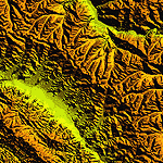
| "Himalayan Peaks" LOD10 Mesh, Volume 5 - Garhwal |

|
File Description:
Highly detailed terrain mesh of the Garhwal area, N30°-32° E78°-81°. The files in this package are based on Shuttle Radar (SRTM) Version 2 data but with many of the void areas, especially the most significant sections, filled with elevation data generated from topographic maps by Jonathan de Ferranti. While Jonathan's work is unrelated to flight simulation he kindly gave me permission to compile his data for use in FS. The result is a wonderful improvement in detail and accuracy over any existing mesh file, freeware or commercial, based on SRTM or DTED data alone. Due to the large area of the Himalayas I've compiled the source data as two separate series: the "Himalayan Peaks" series covers prominent mountains and ranges in higher detail and locally overrides any existing LOD9 terrain mesh. In addition, a LOD9 "base mesh" series covering the entire Himalayas will be available for those who do not yet have an add-on terrain mesh of these beautiful mountains.
| Filename: | Himalayan_Peaks_LOD10_Mesh_Volume_5__Garhwal.zip |
| License: | Freeware, limited distribution |
| Added: | 18th February 2006, 23:16:47 |
| Downloads: | 10,132 |
| Author: | Holger Sandmann and Jonathan de Ferranti |
| Size: | 27.72 MB |
| Category: Flight Simulator 2004 - Scenery | |
| "Himalayan Peaks" LOD10 Mesh, Volume 7 - K2 and Karakoram |
|
Images related to this file:
File Description:

Highly detailed terrain mesh of the Karakoram area, N35-37 E73-77. The files in this package are based on Shuttle Radar (SRTM) Version 2 data but with many of the void areas, especially the most significant sections, filled with elevation data generated from topographic maps by Jonathan de Ferranti. While Jonathan's work is unrelated to flight simulation he kindly gave me permission to compile his data for use in FS. The result is a wonderful improvement in detail and accuracy over any existing mesh file, freeware or commercial, based on SRTM or DTED data alone.
Due to the large area of the Himalayas I've compiled the source data as two separate series: the "Himalayan Peaks" series covers prominent mountains and ranges in higher detail and locally overrides any existing LOD9 terrain mesh. In addition, a LOD9 "base mesh" series covering the entire Himalayas will be available for those who do not yet have an add-on terrain mesh of these beautiful mountains.
| Filename: | Himalayan_Peaks_LOD10_Mesh_Volume_7__K2_and_Karako.zip |
| License: | Freeware, limited distribution |
| Added: | 30th May 2010, 09:56:27 |
| Downloads: | 9,475 |
| Author: | Holger Sandmann, Jonathan de Ferranti |
| Size: | 38.58 MB |
| Category: Flight Simulator 2004 - Scenery | |
| "Himalayan Peaks" LOD10 Mesh, Volume 6 - Jammu and Kashmir |
|
Images related to this file:
File Description:
Highly detailed terrain mesh of the Jammu and Kashmir areas, N31-36 E76-78. The files in this package are based on Shuttle Radar (SRTM) Version 2 data but with many of the void areas, especially the most significant sections, filled with elevation data generated from topographic maps by Jonathan de Ferranti. While Jonathan's work is unrelated to flight simulation he kindly gave me permission to compile his data for use in FS. The result is a wonderful improvement in detail and accuracy over any existing mesh file, freeware or commercial, based on SRTM or DTED data alone.
Due to the large area of the Himalayas I've compiled the source data as two separate series: the "Himalayan Peaks" series covers prominent mountains and ranges in higher detail and locally overrides any existing LOD9 terrain mesh. In addition, a LOD9 "base mesh" series covering the entire Himalayas will be available for those who do not yet have an add-on terrain mesh of these beautiful mountains.
| Filename: | Himalayan_Peaks_LOD10_Mesh_Volume_6__Jammu_and_Kas.zip |
| License: | Freeware, limited distribution |
| Added: | 29th May 2010, 08:55:43 |
| Downloads: | 9,664 |
| Author: | Holger Sandmann, Jonathan de Ferranti |
| Size: | 52.19 MB |
| Category: Flight Simulator 2002 - Panels | |
| Cessna 208B Grand Caravan Panel Mod |
|
File Description:
A modification of the default Cessna 208B panel. For FS2002 Pro only. Modified bitmap provides better overview of panel, while multiple pop-ups assist in readability of smaller instruments. Has support for Reality XP flight line avionics.
| Filename: | Cessna_208B_Grand_Caravan_Panel_Mod.zip |
| License: | Freeware, limited distribution |
| Added: | 20th October 2002, 14:37:48 |
| Downloads: | 847 |
| Author: | Scott Jensen |
| Size: | 461.27 KB |
| Category: Flight Simulator X - Sounds | |
| A380 Callsign Set for FSX/P3D |
|
File Description:
A380 Callsign Set for FSX/P3D. This is a collection of 16 A380 callsigns which cover all past and current operators, and requires EditVoicePack XL to install. Please read documentation for special instructions. Modification by Michael Pearson.
| Filename: | A380_Callsign_Set_for_FSXP3D.zip |
| License: | Freeware |
| Added: | 15th March 2020, 22:03:14 |
| Downloads: | 462 |
| Author: | Michael Pearson |
| Size: | 18.46 KB |
| Category: Flight Simulator 2004 - Scenery | |
| LFID 2006 - Herret Airfield |
|
Images related to this file:
File Description:

FS2004 Scenery--Herret Airfield (LFID), v2.1. Herret is situated in the southwest of France (between the towns of Condom and Valence-sur-Baise) and is used by GA aircraft and gliders. This scenery comes with appropriate AFCAD and traffic files. Compatible with payware Ultimate Terrain Europe and Raimondo Taburet's Roads of France. By Philippe Tonin.
| Filename: | LFID_2006__Herret_Airfield.zip |
| License: | Freeware, limited distribution |
| Added: | 7th May 2015, 00:23:23 |
| Downloads: | 320 |
| Author: | Philippe Tonin |
| Size: | 4.9 MB |
| Category: Flight Simulator 2004 - Scenery | |
| Hong Kong VFR v.0.5 Alpha (Photo Scenery) |
|
Images related to this file:
File Description:
This is a photo scenery of Hong Kong in alpha stage which was finished in 2010. The scenery is just similar with Project Visual Hong Kong but with accurate coordinates. The scenery covers a part of Shenzhen and most part of Hong Kong (Except the North East Part of Hong Kong). Terrain mesh is included.
| Filename: | Hong_Kong_VFR_v05_Alpha_Photo_Scenery.zip |
| License: | Freeware |
| Added: | 9th October 2011, 20:36:38 |
| Downloads: | 1,823 |
| Author: | Thomas Lau |
| Size: | 51.13 MB |
| Category: Flight Simulator 2004 - Scenery | |
| Scotflight UT Europe Fix |
|
File Description:
This helps to fix the problems encountered when using Scotflight Scenery and Ultimate Terrain Europe.
Building textures are missing and there are issues with coastlines.
This file deals primarily with the River Forth and Edinburgh area (my region) but if you encounter
similar oddities in another region, apply the same principle to the fix.
| Filename: | Scotflight_UT_Europe_Fix.zip |
| License: | Freeware |
| Added: | 12th October 2008, 20:30:09 |
| Downloads: | 394 |
| Author: | Keith Mc Kinlay |
| Size: | 618.9 KB |
| Category: Flight Simulator 2004 - Scenery | |
| Himalayas LOD9 Base Mesh, Volume 3 - Southwestern Ranges |
|
Images related to this file:
File Description:
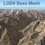
Detailed terrain mesh of the Southwestern Himalayan Ranges, N28-37 E78-82. The files in this package are based on Shuttle Radar (SRTM) Version 2 data but with many of the void areas, especially the most significant sections, filled with elevation data generated from topographic maps by Jonathan de Ferranti. While Jonathan's work is unrelated to flight simulation he kindly gave me permission to compile his data for use in FS. The result is a wonderful improvement in detail and accuracy over any existing mesh file, freeware or commercial, based on SRTM or DTED data alone.
Due to the large area of the Himalayas I've compiled the source data as two separate series: the "Himalayan Peaks" series covers prominent mountains and ranges in higher detail and locally overrides any existing LOD9 terrain mesh. In addition, the LOD9 "base mesh" series, with LOD8 and LOD7 "buffer" mesh files, covering the entire Himalayas, is meant for those who do not yet have an add-on terrain mesh of these beautiful mountains.
| Filename: | Himalayas_LOD9_Base_Mesh_Volume_3__Southwestern_Ra.zip |
| License: | Freeware, limited distribution |
| Added: | 30th May 2010, 10:00:26 |
| Downloads: | 155,808 |
| Author: | Holger Sandmann, Jonathan de Ferranti |
| Size: | 62.16 MB |
| Category: Flight Simulator 2004 - Scenery | |
| Himalayas LOD9 Base Mesh, Volume 4 - Kashmir and Jammu |
|
File Description:
Detailed terrain mesh of the Kashmir and Jammu Ranges, N30-39 E76-78. The files in this package are based on Shuttle Radar (SRTM) Version 2 data but with many of the void areas, especially the most significant sections, filled with elevation data generated from topographic maps by Jonathan de Ferranti. While Jonathan's work is unrelated to flight simulation he kindly gave me permission to compile his data for use in FS. The result is a wonderful improvement in detail and accuracy over any existing mesh file, freeware or commercial, based on SRTM or DTED data alone.
Due to the large area of the Himalayas I've compiled the source data as two separate series: the "Himalayan Peaks" series covers prominent mountains and ranges in higher detail and locally overrides any existing LOD9 terrain mesh. In addition, the LOD9 "base mesh" series, with LOD8 and LOD7 "buffer" mesh files, covering the entire Himalayas, is meant for those who do not yet have an add-on terrain mesh of these beautiful mountains.
| Filename: | Himalayas_LOD9_Base_Mesh_Volume_4__Kashmir_and_Jam.zip |
| License: | Freeware, limited distribution |
| Added: | 22nd February 2006, 20:32:50 |
| Downloads: | 7,504 |
| Author: | Holger Sandmann, Jonathan de Ferranti |
| Size: | 29.24 MB |
© 2001-2026 AVSIM Online
All Rights Reserved
Privacy Policy |